| Pages:
1
2 |
ehall
Super Nomad

Posts: 1906
Registered: 3-29-2014
Location: Buckeye, Az
Member Is Offline
Mood: It's 5 o'clock somewhere
|
|
Matomi Ranch
Anyone know if it is possible to drive a jeep or truck up Matomi wash from hwy 5 to Matomi Ranch?
|
|
|
David K
Honored Nomad
Posts: 65562
Registered: 8-30-2002
Location: San Diego County
Member Is Offline
Mood: Have Baja Fever
|
|
Ed, the real question might be about those last 5 miles. I last went there in 2006. The ranch was not occupied then.
http://vivabaja.com/618 starting about page 3 of that site.
[Edited on 3-2-2016 by David K]
|
|
|
ehall
Super Nomad
Posts: 1906
Registered: 3-29-2014
Location: Buckeye, Az
Member Is Offline
Mood: It's 5 o'clock somewhere
|
|
I wasn't planning on going to the ranch but turning North and going all the way to hwy 3. Just wasn't sure on the wash because on google earth it
looks narrow and rocky in a couple spots.
|
|
|
David K
Honored Nomad
Posts: 65562
Registered: 8-30-2002
Location: San Diego County
Member Is Offline
Mood: Have Baja Fever
|
|
The race just came down it, so it is wide open. See my web page photos as we did the same, all the way north to Hwy 3 via Diablo Dry Lake... I also
did that in 2004 after exploring the canyons north of Matomi. That trip is at http://vivabaja.com/404
|
|
|
ehall
Super Nomad
Posts: 1906
Registered: 3-29-2014
Location: Buckeye, Az
Member Is Offline
Mood: It's 5 o'clock somewhere
|
|
Thanks David. Exactly what I needed.
|
|
|
David K
Honored Nomad
Posts: 65562
Registered: 8-30-2002
Location: San Diego County
Member Is Offline
Mood: Have Baja Fever
|
|
Ed, one thing about going in any arroyo after a race uses it, it might be really chewed up, whoops, or a high crown is created as most of the route is
sand.
|
|
|
PaulW
Ultra Nomad
Posts: 3113
Registered: 5-21-2013
Member Is Offline
|
|
Best way to go is Morelia road to valley Chico then enter Matomi and head up the canyon.
Up hill in Matomi is an issue. Down hill like the racers is much easier.
|
|
|
ehall
Super Nomad
Posts: 1906
Registered: 3-29-2014
Location: Buckeye, Az
Member Is Offline
Mood: It's 5 o'clock somewhere
|
|
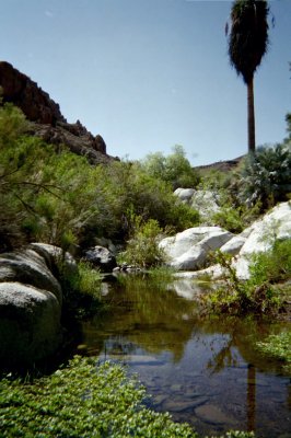
Thanks david and paul. David, those pictures in that link where great. Never imagined there would be so much water back there.
|
|
|
bajapedro
Nomad
Posts: 152
Registered: 3-2-2016
Member Is Offline
|
|
We were just there week before the race.
We were in rzr's but it should be passable by truck or jeep.
One pretty rocky spot at the "narrows" but if you take your time should be ok.
Now the last 6 miles to the Rancho are pretty rugged.
|
|
|
David K
Honored Nomad
Posts: 65562
Registered: 8-30-2002
Location: San Diego County
Member Is Offline
Mood: Have Baja Fever
|
|
Quote: Originally posted by ehall  | | Thanks david and paul. David, those pictures in that link where great. Never imagined there would be so much water back there. |
Baja is full of surprises!
See our trip there in 2004 beginning on this page (this is all about 5 miles up from where you would exit Matomi for Valle Chico to go north; behind
the ranch house): http://www.vivabaja.com/204/page8.html
Matomi Falls!


It is great in the summer! Of course it takes hours to get back in there!
|
|
|
bajatrailrider
Ultra Nomad
Posts: 2553
Registered: 1-24-2015
Location: Mexico
Member Is Offline
Mood: Happy
|
|
| Quote: Originally posted by ehall | | Anyone know if it is possible to drive a jeep or truck up Matomi wash from hwy 5 to Matomi Ranch? |
Ed I know you can relate to this.Last time I was in Motomi wash over 20 years
ago. Riding XR650r,with 5 gal tank,two back packs.Deep sand completely out of control.Bike way too heavy.So had to ride wide open,the widest part of
wash. 3/5 car lengths.I went from side to side,using every foot.The one place it gets narrow/and big rocks.Over the bars. When are you planning this run? When are you planning this run?
|
|
|
Barry A.
Select Nomad
Posts: 10007
Registered: 11-30-2003
Location: Redding, Northern CA
Member Is Offline
Mood: optimistic
|
|
| Quote: Originally posted by PaulW | Best way to go is Morelia road to valley Chico then enter Matomi and head up the canyon.
Up hill in Matomi is an issue. Down hill like the racers is much easier. |
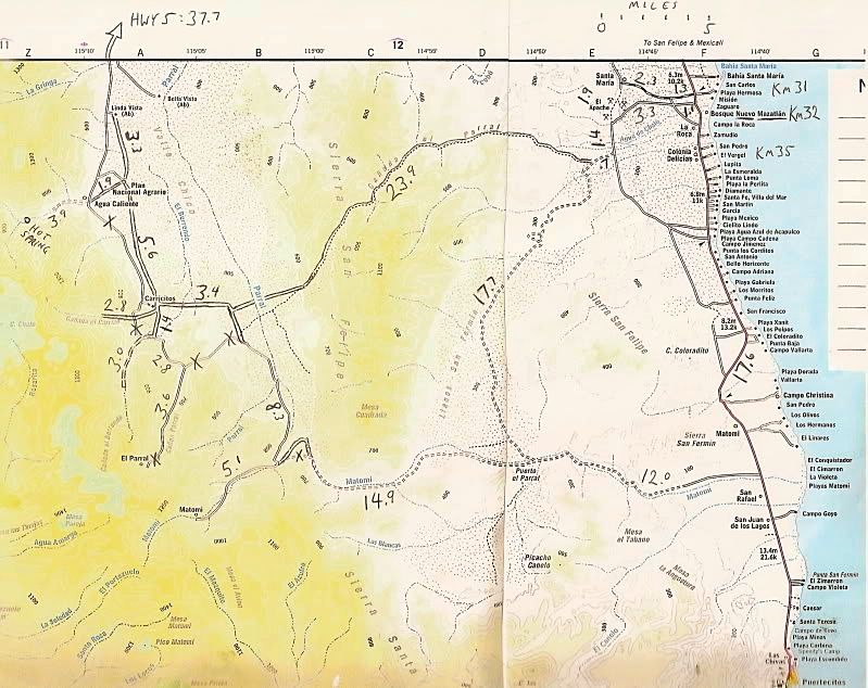
Paul-------there use to be an easy way into Valle Chico about 10 miles north of the Matomi Narrows. It went west from the El Apache Mine up and over
the Sierra San Felipe via Parral Canyon and into the south end of Valle Chico. It was also called "Azufre" and "Crazy Horse" by some, I think. It
shows on the Baja Atlas as a trail, but it was actually a fine jeep-track with no problems. Is that jeep-track still open, do you know?
|
|
|
Ken Cooke
Elite Nomad
Posts: 8971
Registered: 2-9-2004
Location: Riverside, CA
Member Is Offline
Mood: Pole Line Road postponed due to injury
|
|
After seeing the boulders in David's photos from several years ago, I thought this area would never be passable again. Good to hear the narrows can
be navigated again.
|
|
|
David K
Honored Nomad
Posts: 65562
Registered: 8-30-2002
Location: San Diego County
Member Is Offline
Mood: Have Baja Fever
|
|
| Quote: Originally posted by Barry A. | | Quote: Originally posted by PaulW | Best way to go is Morelia road to valley Chico then enter Matomi and head up the canyon.
Up hill in Matomi is an issue. Down hill like the racers is much easier. |
Paul-------there use to be an easy way into Valle Chico about 10 miles north of the Matomi Narrows. It went west from the El Apache Mine up and over
the Sierra San Felipe via Parral Canyon and into the south end of Valle Chico. It was also called "Azufre" and "Crazy Horse" by some, I think. It
shows on the Baja Atlas as a trail, but it was actually a fine jeep-track with no problems. Is that jeep-track still open, do you know?
|
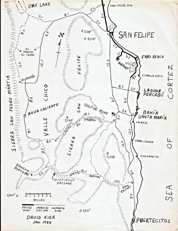
Cañada el Parral (Azufre Wash/ Crazyhorse Canyon) was a fun route to find my first time through, in 1978.
It begins just a couple miles south of the sulfur (azufre) mine... in 1978 it was unused and only by finding parallel lines of grass could I find the
route into and through the canyon (it was December and rainy, so wild grass grew in the slightly depressed remains of tire tracks where water
collected.
I was ith friends and they helped by hopping out of my 4WD Subaru and moving rocks. for my (lower than most 4x4s) to get through.
|
|
|
PaulW
Ultra Nomad
Posts: 3113
Registered: 5-21-2013
Member Is Offline
|
|
| Quote: Originally posted by Barry A. | | Quote: Originally posted by PaulW | Best way to go is Morelia road to valley Chico then enter Matomi and head up the canyon.
Up hill in Matomi is an issue. Down hill like the racers is much easier. |
Paul-------there use to be an easy way into Valle Chico about 10 miles north of the Matomi Narrows. It went west from the El Apache Mine up and over
the Sierra San Felipe via Parral Canyon and into the south end of Valle Chico. It was also called "Azufre" and "Crazy Horse" by some, I think. It
shows on the Baja Atlas as a trail, but it was actually a fine jeep-track with no problems. Is that jeep-track still open, do you know?
|
==========
Hi Barry,
Correct. I recently drove up Azufre. Hot and slow easy enough for any 4x4. IGENI map H11B67 It locates Mina el Apache N of the entrance to Azufre.
Forever everyone calls the mine as the Sulphur mine and there are several other digs on the map nearby. There is another place at the arroyo entrance
the locals called Apache Tears. Were we are still finding the obsidian remnants of the volcanic activity. The INEGI map does call the arroyo Parral
along with several other drainage's with the same name. Anyway we are all talking about the same canyon. Don't worry about Azufre -easy.
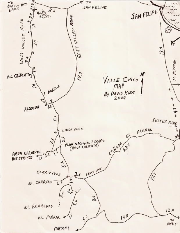
For aneven easier but longer way just head out to the valley via Zoo road and drive S on Morelia road past the corral and on to Matomi. 40MPH+ all the
way to Matomi. Easy 2wd drive until you start up Matomi. The many maps David has posted on the Mountain bike thread have all the info you should
need. For my trip we went up Azufre and back to town via Morelia road- long day.
|
|
|
Barry A.
Select Nomad
Posts: 10007
Registered: 11-30-2003
Location: Redding, Northern CA
Member Is Offline
Mood: optimistic
|
|
Many thanks, Paul, and that is good news. We too have spent many days on several trips covering that area, eventually over the years accessing all
the places we wanted to as at times some closed-up due to washouts of the "roads" in, or due to locked gates, while others became accessible. At
times we have been able to drive up to the Hot springs in Agua Caliente Canyon, the Matomi Ranch, El Parral Ranch, etc. whereas other times we have
not been able to------the country is always changing due to extreme weather and ranchers/pot growers fencing it off with locked gates, etc..-----keeps
things exciting and unpredictable.
Thanks again for the new info----it's been several years since we have been in the Valle Chico area.
|
|
|
PaulW
Ultra Nomad
Posts: 3113
Registered: 5-21-2013
Member Is Offline
|
|
Now days we have new fences due to the improving cattle industry. Issues with fence gates.
Of the ones you mentioned Augua Caliente is fenced.
This year water damage is minimal. Its very dry.
|
|
|
Barry A.
Select Nomad
Posts: 10007
Registered: 11-30-2003
Location: Redding, Northern CA
Member Is Offline
Mood: optimistic
|
|
For several years back 8 to 10 years ago, Upper Parral Canyon was locked up with a formidable fence and locked gate where the jeep road over to Parral
from Borrendo Canyon came over the divide and dropped into Parral. Tho I had been to Rancho Parral many many years ago going up Parral from the Valle
Chico road (that section now long washed out?), I have not been able to get into the Ranch for a very long time due to the locked gate. I assume
that Rancho Parral is still not accessible???
|
|
|
PaulW
Ultra Nomad
Posts: 3113
Registered: 5-21-2013
Member Is Offline
|
|
I have not been to Rancho Parral for some years. When I went I had to drive thru two corrals by opening the fence - not locked . The road was way
overgrown due to no traffic. I use the track from Berrendo. I was easy to find. Now that the rancher has so many cattle you could expect more fences.
He has added 3 new pilas with watering troughs along the road from Azufre to the corral.
Tried to get from Parral to Matomi - no go due to heavy flooding and remaining big boulders.
Search for my Berrendo writeup. The rancher has put a steel cable bank to bank and made it into a cattle fence. This means you park there and walk
quite a ways to the blue palms. And there was a fire whereby some bad people torched many of the palms. They were recovering nicely, so I bet they
will look good now days.
|
|
|
David K
Honored Nomad
Posts: 65562
Registered: 8-30-2002
Location: San Diego County
Member Is Offline
Mood: Have Baja Fever
|
|
Been to Parral Ranch location once, in 2004. Was with Jide exploring the Eastside canyons that week. We met Baja Lou and his group at the Entrance to
Parral where the usually locked gate, was open. We camped by the corrals that the road goes right through.
Not far from the corrals, the road was washed out... and it was a 1 mile hike up to the ranch house of El Parral. Lot's of long rock walls surrounded
the rancho.
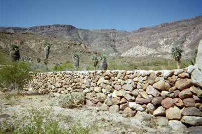


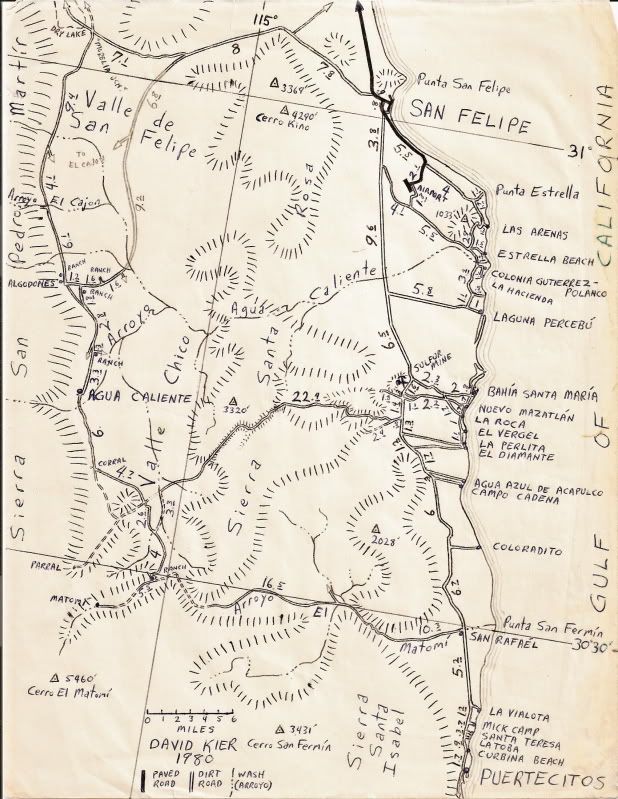
Mile 3.6 was just past the corral the road drives through and where it ended at the new canyon/ washout. The 1.0 mile dashed line is the hiked
portion to the ranch house (per my GPS), seen in the photo above.
|
|
|
| Pages:
1
2 |


