| Pages:
1
2 |
joerover
Banned
Posts: 676
Registered: 2-3-2011
Location: earth
Member Is Offline
Mood: sleepy
|
|
back road around san Felipe
What is the road like for the 250 race_? The back road west of San Felipe.
How could a person on a mt bike get from Parque Nacional Constitución de 1857 to Cocos corner. Without riding to much pavement.
the fat lady is breeding
which means
The fat ladys are breeding
|
|
|
TMW
Select Nomad

Posts: 10659
Registered: 9-1-2003
Location: Bakersfield, CA
Member Is Offline
|
|
The only way from the park is thru Mikes Sky Ranch out to Hwy 3 then across Diablo dry lake. That's about 15 miles of pavement.
|
|
|
mtgoat666
Platinum Nomad
Posts: 21089
Registered: 9-16-2006
Location: San Diego
Member Is Offline
Mood: Hot n spicy
|
|
Chrisx,
Watch out for fat ladies driving Hondas!
|
|
|
PaulW
Ultra Nomad
Posts: 3113
Registered: 5-21-2013
Member Is Offline
|
|
Quote: Originally posted by joerover  | What is the road like for the 250 race_? The back road west of San Felipe.
How could a person on a mt bike get from Parque Nacional Constitución de 1857 to Cocos corner. Without riding to much pavement.
|
======
Yup easy to find,
From L Hansen find the race track to the goat trail near V Trinidad - get on the pavement to Mikes turnoff then do the dirt parallel to hwy3 to L
Diablo
Then ---
1) Take L Diablo to Morelia jct then south to Matomi then pavement to Gonzaga. Other Arroyos will add pavement
2) Take L Diablo the get on Morelia road (ZOO) - dump road - SF250 track - follow the race track to OPR then head south - then suffer with the
terrible bumps after Arroyo Huatamote (the end of the powerline). At the end of OPR its pavement past Matomi to Gonzaga.
Best is option 2 because you will find gas in SF
Do it.
Above works for trucks and bikes done it many times in the Bronco.
Can you translate my words?
Have fun
|
|
|
David K
Honored Nomad
Posts: 65562
Registered: 8-30-2002
Location: San Diego County
Member Is Offline
Mood: Have Baja Fever
|
|
| Quote: Originally posted by TMW | | The only way from the park is thru Mikes Sky Ranch out to Hwy 3 then across Diablo dry lake. That's about 15 miles of pavement.
|
Different park...
Once through San Matias Pass on Hwy. 3 you can take the old road onto Diablo Dry Lake then down Valle Chico to Matomi and east to Hwy. 5, 10 mi north
of Puertecitos. Puertecitos south is new, wide hwy. with bike path wide shoulders on south.
|
|
|
David K
Honored Nomad
Posts: 65562
Registered: 8-30-2002
Location: San Diego County
Member Is Offline
Mood: Have Baja Fever
|
|
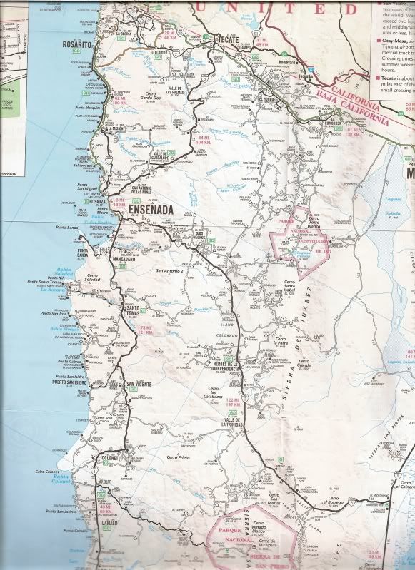
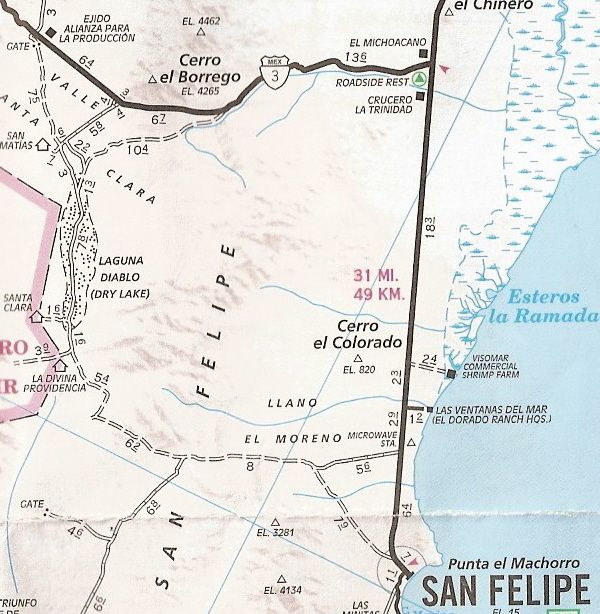
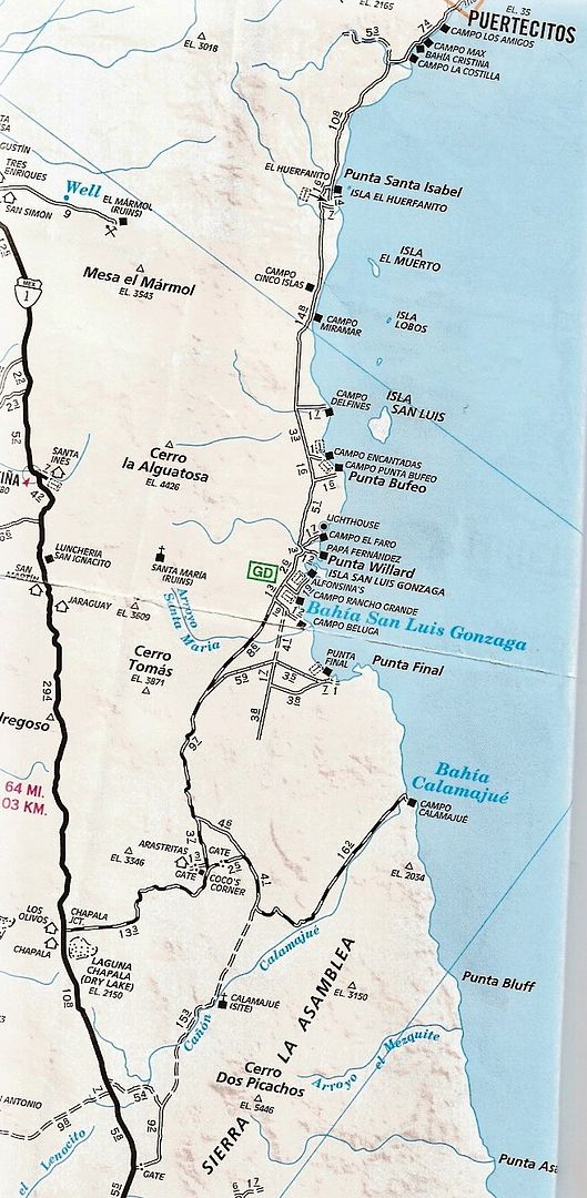
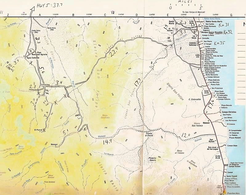
Maps of region... some of the roads shown

|
|
|
TMW
Select Nomad
Posts: 10659
Registered: 9-1-2003
Location: Bakersfield, CA
Member Is Offline
|
|
Sorry I was thinking of the Observatory for some reason.
I do know of a way to get from Laguna Hanson to Cocos with only a mile or two of pavement. I've been on all the roads on either a bike or truck.
Problem is there may be some locked gates.
|
|
|
joerover
Banned
Posts: 676
Registered: 2-3-2011
Location: earth
Member Is Offline
Mood: sleepy
|
|
What about the road from Ejido Allanza para la production, too SAn Filepe? How sandy is it? This is a bicycle, not a ford bronco. There have been
threads in the past about off road mt bikes traveling in the back country areas. I would consider the San Filepe desert the most challenging area of
a trip down the Baja back roads. The San Filepe desert is one of the driest in the world. (Second only to antartica?) I can ride my bike below the
high tide mark, but in the soft sand above the high tide mark I am stuck.
the fat lady is breeding
which means
The fat ladys are breeding
|
|
|
joerover
Banned
Posts: 676
Registered: 2-3-2011
Location: earth
Member Is Offline
Mood: sleepy
|
|
Are these roads hard pack or soft sand?
I can push the bike for a mile.
Attempting to push for 50 miles could be a death sentence!
the fat lady is breeding
which means
The fat ladys are breeding
|
|
|
joerover
Banned
Posts: 676
Registered: 2-3-2011
Location: earth
Member Is Offline
Mood: sleepy
|
|
I suppose there is no water at all anywhere back there?
Are these maps much different than the National Geographic baja maps?
the fat lady is breeding
which means
The fat ladys are breeding
|
|
|
AKgringo
Elite Nomad
Posts: 6358
Registered: 9-20-2014
Location: Anchorage, AK (no mas!)
Member Is Offline
Mood: Retireded
|
|
It is a minor point Joe, but the dry dessert you were thinking of is probably the Atacama (Chile). The only water that reaches some parts of it comes
down down from the mountains.
As far as dirt roads paralleling hwy five south from Puertecito to Coco's, I think you would find that the sand has washed from the steep spots
(exposing rocks) and into the flat spots (piling up sand).
Fortunately, that new stretch of highway is wide enough to ride with much more safety than highway 1.
If you are not living on the edge, you are taking up too much space!
"Could do better if he tried!" Report card comments from most of my grade school teachers. Sadly, still true!
|
|
|
David K
Honored Nomad
Posts: 65562
Registered: 8-30-2002
Location: San Diego County
Member Is Offline
Mood: Have Baja Fever
|
|
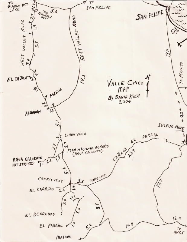
The East Valley road to Carricitos from San Felipe is graded. The dashed line road from Ejido Alinanza to the dry lake and then the West Valley Road
are both sand based. Matomi is also mostly deep sand. Sounds like you need to replan the route ideas for your vehicle of choice?
Do you need a look at the Nat Geo maps here?
|
|
|
joerover
Banned
Posts: 676
Registered: 2-3-2011
Location: earth
Member Is Offline
Mood: sleepy
|
|
¨Do you need a look at the Nat Geo maps here? ¨
Nat geo maps_? What is that?
Is there a wy around the paved 5? Without sinking in the sand?
the fat lady is breeding
which means
The fat ladys are breeding
|
|
|
joerover
Banned
Posts: 676
Registered: 2-3-2011
Location: earth
Member Is Offline
Mood: sleepy
|
|
It is possible to ride dirt on the pacific side, most of the way down. But there is a safety question. I asked in the Migration office a few years
back. They siad to go the other side, (San Felipe)
the fat lady is breeding
which means
The fat ladys are breeding
|
|
|
David K
Honored Nomad
Posts: 65562
Registered: 8-30-2002
Location: San Diego County
Member Is Offline
Mood: Have Baja Fever
|
|
| Quote: Originally posted by joerover | ¨Do you need a look at the Nat Geo maps here? ¨
Nat geo maps_? What is that?
Is there a wy around the paved 5? Without sinking in the sand? |
You are the one who mentioned Nat Geo maps. If you can't do sand, then avoiding pavement is not likely in my opinion. Sorry I couldn't help more.
|
|
|
PaulW
Ultra Nomad
Posts: 3113
Registered: 5-21-2013
Member Is Offline
|
|
| Quote: Originally posted by joerover | I suppose there is no water at all anywhere back there?
Are these maps much different than the National Geographic baja maps? |
====
Joe, I thought you were aware if the race maps? If not find them - you need definition all the dirt roads you can use from L Hanson to COCOs and
beyond. You will not find published maps that I am aware of for your purpose. See below.
For a Mtn biker please stay as close to population for your water and cooking fuel. Once you get west of the San Felipe mountains you will just find
desert and unless you have a chase vehicle you will not find any help unless prearranged. Your trip time from hwy3 to hwy5 is going to be several
days. For my route"1" last water in at San Matias next water is at the well at Hwy5 KM61.
For route "2" after San Matias get water at the PMEX hwy5 KM182. Then go back to the dump road or the powerline road and head south on the race track.
heading S find last water at the village Las Minitas on OPR just south of SF.
OPR= Old Puertecitos Road
Maps:
Starting place download the INEGI topo maps starting with H11B35, 46, 47, 57 and any others that you need (free). Find instructions at
http://www.blueroadrunner.com/phpbb/viewtopic.php?f=2&t=...
Another even better source for your trip maps is Murdocknav.com
He sells GPS background maps for Garmin and Lowrance and his maps show exactly the roads you need. Look and my blog which has GPS screen shots for
some areas near the sea to see what kind you will see on your GPS. Roads on his maps are proven roads.
http://www.blueroadrunner.com/phpbb/viewtopic.php?f=2&t=...
BTW you will not succeed without a good GPS as the roads are numerous and any paper ones to take will be very confusing without GPS coordinates.
If you have a Sat phone or Inreach contact me and I will come and supply you. Contact info via U2U after you do your homework.
Enjoy your trip.
|
|
|
mtgoat666
Platinum Nomad
Posts: 21089
Registered: 9-16-2006
Location: San Diego
Member Is Offline
Mood: Hot n spicy
|
|
Chrisx,
If you take the desert route, I suggest you drive it first by car and stash water/food.
If your goal is a north to south trip, I suggest you stick to high mtns, until on south side of SPM plateau, then take roads on west side of crest.
There are cattle trail routes from SPM plateau southward, southwestward, but you'll have to be adventurous.
|
|
|
AKgringo
Elite Nomad
Posts: 6358
Registered: 9-20-2014
Location: Anchorage, AK (no mas!)
Member Is Offline
Mood: Retireded
|
|
Joe, do you have a time frame in mind for your ride, and are you doing this solo?
I don't have any dates planned yet for a trip SOB, but if I am down there during your ride, I would be willing to stash, or deliver supplies to
landmarks you choose. That goes a ride out in case of injury or mechanical break down as well.
If you are not living on the edge, you are taking up too much space!
"Could do better if he tried!" Report card comments from most of my grade school teachers. Sadly, still true!
|
|
|
joerover
Banned
Posts: 676
Registered: 2-3-2011
Location: earth
Member Is Offline
Mood: sleepy
|
|
| Quote: Originally posted by PaulW | | Quote: Originally posted by joerover | I suppose there is no water at all anywhere back there?
Are these maps much different than the National Geographic baja maps? |
====
Joe, I thought you were aware if the race maps? If not find them - you need definition all the dirt roads you can use from L Hanson to COCOs and
beyond. You will not find published maps that I am aware of for your purpose. See below.
For a Mtn biker please stay as close to population for your water and cooking fuel. Once you get west of the San Felipe mountains you will just find
desert and unless you have a chase vehicle you will not find any help unless prearranged. Your trip time from hwy3 to hwy5 is going to be several
days. For my route"1" last water in at San Matias next water is at the well at Hwy5 KM61.
For route "2" after San Matias get water at the PMEX hwy5 KM182. Then go back to the dump road or the powerline road and head south on the race track.
heading S find last water at the village Las Minitas on OPR just south of SF.
OPR= Old Puertecitos Road
Maps:
Starting place download the INEGI topo maps starting with H11B35, 46, 47, 57 and any others that you need (free). Find instructions at
http://www.blueroadrunner.com/phpbb/viewtopic.php?f=2&t=...
Another even better source for your trip maps is Murdocknav.com
He sells GPS background maps for Garmin and Lowrance and his maps show exactly the roads you need. Look and my blog which has GPS screen shots for
some areas near the sea to see what kind you will see on your GPS. Roads on his maps are proven roads.
http://www.blueroadrunner.com/phpbb/viewtopic.php?f=2&t=...
BTW you will not succeed without a good GPS as the roads are numerous and any paper ones to take will be very confusing without GPS coordinates.
If you have a Sat phone or Inreach contact me and I will come and supply you. Contact info via U2U after you do your homework.
Enjoy your trip. |
I need a day or so to study this. I have a garmin, and a solar charger.
the fat lady is breeding
which means
The fat ladys are breeding
|
|
|
joerover
Banned
Posts: 676
Registered: 2-3-2011
Location: earth
Member Is Offline
Mood: sleepy
|
|
| Quote: Originally posted by AKgringo | Joe, do you have a time frame in mind for your ride, and are you doing this solo?
I don't have any dates planned yet for a trip SOB, but if I am down there during your ride, I would be willing to stash, or deliver supplies to
landmarks you choose. That goes a ride out in case of injury or mechanical break down as well. |
A kind offer, WOW.
I am thinking soon before it gets to hot.
Davidk said
¨You are the one who mentioned Nat Geo maps. If you can't do sand, then avoiding pavement is not likely in my opinion. Sorry I couldn't help more.¨
Nat Geo did not register in my head as National Geographic maps, which is what I have. The latest craze in cycling is a 27.5 x 3 inch tire. Probably
more capeable of this route. I may get one of those next year. The first model year always sucks. What I have is a 26 x 2.3 inch tire. Not enough
for sand, good for rocks and hard pack or loose, but sand means pushing. My 29 x 2.5 inch tires are almost, but not quite enough for sand.
I got an old fasioned 26 inch wheeled bike so I could cycle in Guatemala and other such places where they do not have the latest parts for sale. If
any one cares, it is a Ritchey break away frame. The frame splits in half, and the entire bike fits into a 61.9 liner inch hard case for flying.
It would be good to have a cycle route along the entire Baja. I mean a mt bike route. Away from cars. The San Felipe desert is the hardest place to
get through. Or so it would seem.
I will study this and report back in a couple of days
I suggest that you spend semana santa in Guatemala. They celebrate with style
the ruins are a long hot walk, a cycle could help
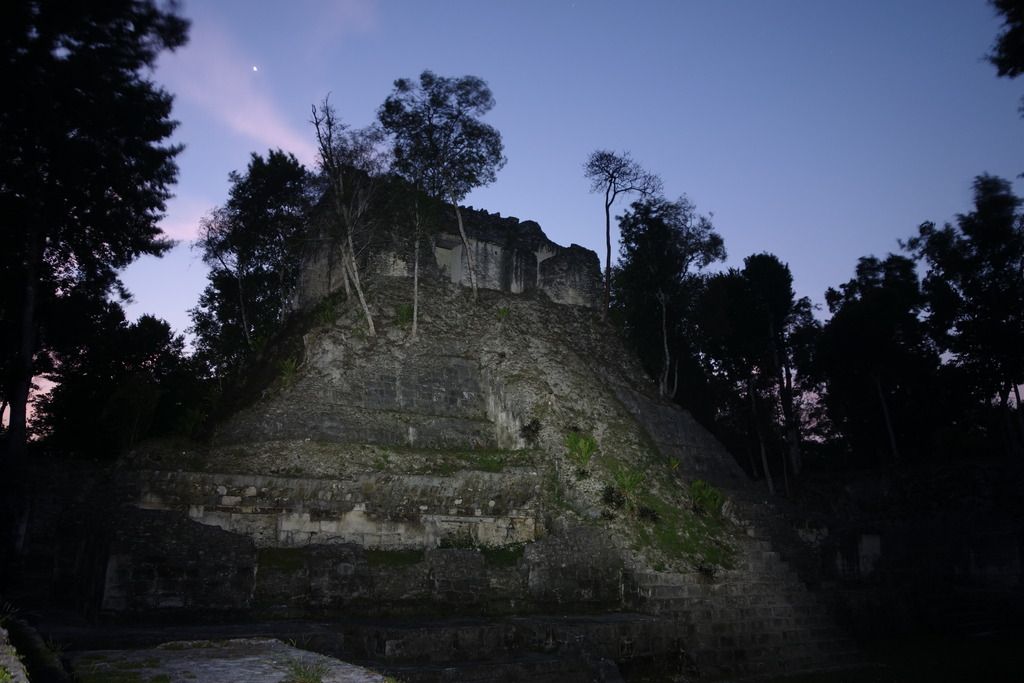
guarding a 2,500 year old calendar
the fat lady is breeding
which means
The fat ladys are breeding
|
|
|
| Pages:
1
2 |


