bajajohn
Newbie
Posts: 9
Registered: 2-2-2014
Location: Punta Banda, BCN<, Mx
Member Is Offline
|
|
Campgrounds between Tecate & Puerto Penasco
Are there any campgrounds for RV's between Tecate and Puerto Penasco?
|
|
|
Udo
Elite Nomad
     
Posts: 6364
Registered: 4-26-2008
Location: Black Hills, SD/Ensenada/San Felipe
Member Is Offline
Mood: TEQUILA!
|
|
ZERO.
There is one about an hour north of Pe˝asco, but when you are that close to your destination...
Udo
Youth is wasted on the young!
|
|
|
TMW
Select Nomad
      
Posts: 10659
Registered: 9-1-2003
Location: Bakersfield, CA
Member Is Offline
|
|
There is Rancho Ojai at KM112 east of Tecate. It's a former KOA campground. It's on the free road. I've never stayed there.
|
|
|
ehall
Super Nomad
   
Posts: 1906
Registered: 3-29-2014
Location: Buckeye, Az
Member Is Offline
Mood: It's 5 o'clock somewhere
|
|
What Udo said. Not sure how the campground is but El golfo de santa clara has a nice cantina. It's called el capitan and Alex the bartender speaks
good english. Great shrimp and cold beer. There is also a pemex in town.
|
|
|
David K
Honored Nomad
        
Posts: 65422
Registered: 8-30-2002
Location: San Diego County
Member Is Offline
Mood: Have Baja Fever
|
|
Just a thought, go down the Guadalupe Canyon graded road (2 miles west of Laguna Salada) a few miles to Cant˙ Palms... an oasis canyon much closer to
Hwy. 2 than Guadalupe Canyon campgrounds, 35 miles south of the highway.
I am on my cell phone but will try and post directions later. Cantű Palms was made popular by Desert Magazine editor Randall Henderson in the 1940s
seeking blue palms.
EDIT:
Read the article:
http://dezertmagazine.com/mine/1946DM08/index.html
(flip to Page 12)...
Maps (1946):
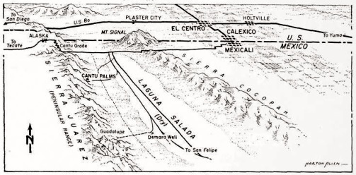 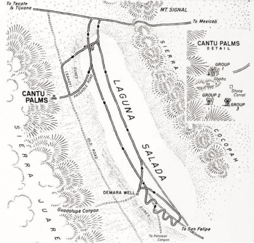
On the 1974 Auto Club Baja Map:
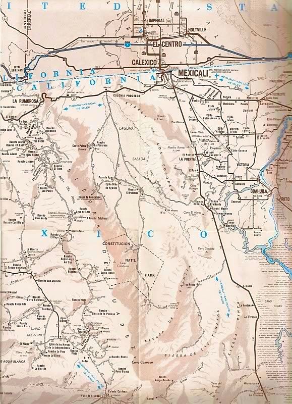
Those mileages are hard to see here, the first section on the dry lake bed road is 6 miles, the fork to the right goes another 10.3 miles to Rancho La
Ponderosa. Cant˙ Palms is 0.8 mile beyond the ranch.
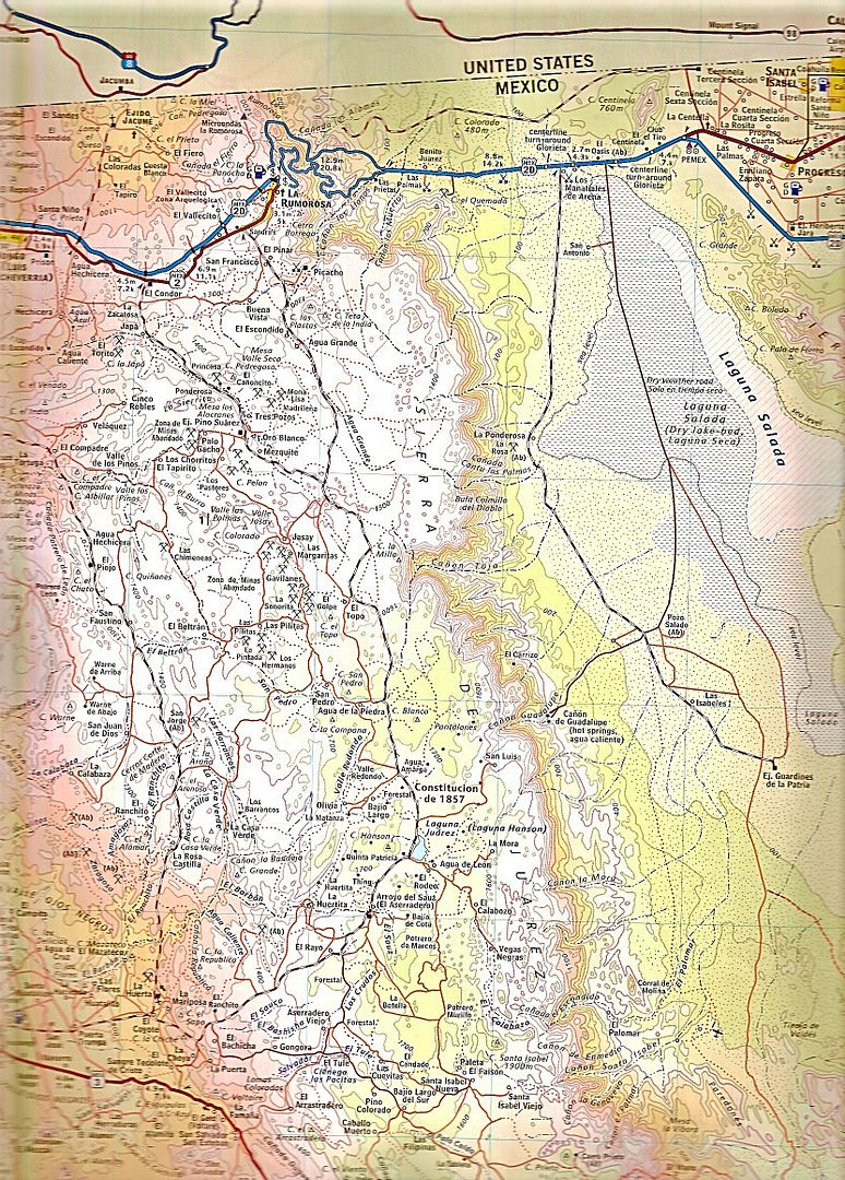
Today, a graded road runs south from Hwy. 2 (about where the 1946 map shows an "old road").
On the Almanac map, it is called Ca˝ada Cant˙ las Palmas, just beyond La Ponderosa...
[Edited on 4-29-2016 by David K]
|
|
|
David K
Honored Nomad
        
Posts: 65422
Registered: 8-30-2002
Location: San Diego County
Member Is Offline
Mood: Have Baja Fever
|
|
GPS DATA (WGS 84/ Google Earth)
Rancho La Ponderosa: 32║21.720', -115║48.310'
Cant˙ Palms (corral by Group 3 palms on map): 32║20.940', -115║49.630'
|
|
|
mcnut
Nomad
 
Posts: 177
Registered: 12-9-2013
Location: Dammeron Valley, UT
Member Is Offline
|
|
Full disclaimer; I have never been in this area or read/talked to anyone who has. All my info has been acquired from GE imagery.
If you are going the paved gulf road; There looks to be 3-4 beach front campgrounds in the town of Golfo de Santa Clara (31░ 40.608'N, 114░ 29.310'W).
At least one looks to have formal RV pads/sites and the others are sand/polapa based, some with restaurant. The town also has some nicer looking
Hotels so they do serve tourists. The Campo to the far right is located close to what appears to be an OHV play area and as a result may be somewhat
noisy/rowdy.
Update: The camp with what looks to be pads, El Golfo Beach Resort sounds like a member only campground.
Click on image for full size image.
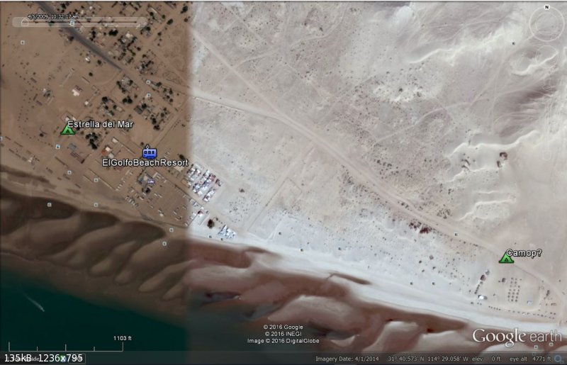
[Edited on 12-25-2016 by mcnut]
[Edited on 12-26-2016 by mcnut]
|
|
|
fish101
Nomad
 
Posts: 132
Registered: 7-2-2011
Location: Loreto BCS
Member Is Offline
Mood: energized
|
|
Quote: Originally posted by TMW  | | There is Rancho Ojai at KM112 east of Tecate. It's a former KOA campground. It's on the free road. I've never stayed there. |
I stayed here several years ago and found that their electric was not within spec for 120 volts.. I measured 136 volts, which surprised the owner, but
he measured it in his office as well. I could not plug in that night as I have a power monitor in the motorhome that would not allow that much power.
Hopefully, they have corrected it by now...
[Edited on 12-27-2016 by fish101]
|
|
|

