Aldervale
Junior Nomad

Posts: 95
Registered: 12-22-2013
Member Is Offline
|
|
Sierra de Mulege ?
Howdy
Is there anyone here experienced with the area west of Mulege city ?
Does the road past the Mission lead very far into ( or over ? ) the central spine of the penninsula ?
Looking for a loop route west and south then back to Loreto....history and natural history.
Suggestions for directing my search here or another site?
Many thanks
Aldervale
|
|
|
David K
Honored Nomad
Posts: 65588
Registered: 8-30-2002
Location: San Diego County
Member Is Offline
Mood: Have Baja Fever
|
|
Hope this helps!
Here is the Auto Club (2010) map of the roads west of Mulegé, that go to mission-era sites, and beyond:
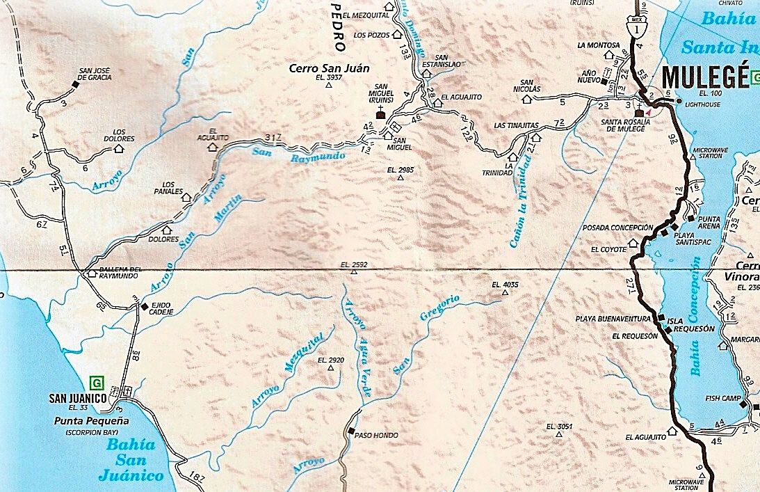
The road between San José de Magdalena and Mission Guadalupe has been closed to landslide/washout.
[Edited on 11-25-2016 by David K]
|
|
|
David K
Honored Nomad
Posts: 65588
Registered: 8-30-2002
Location: San Diego County
Member Is Offline
Mood: Have Baja Fever
|
|
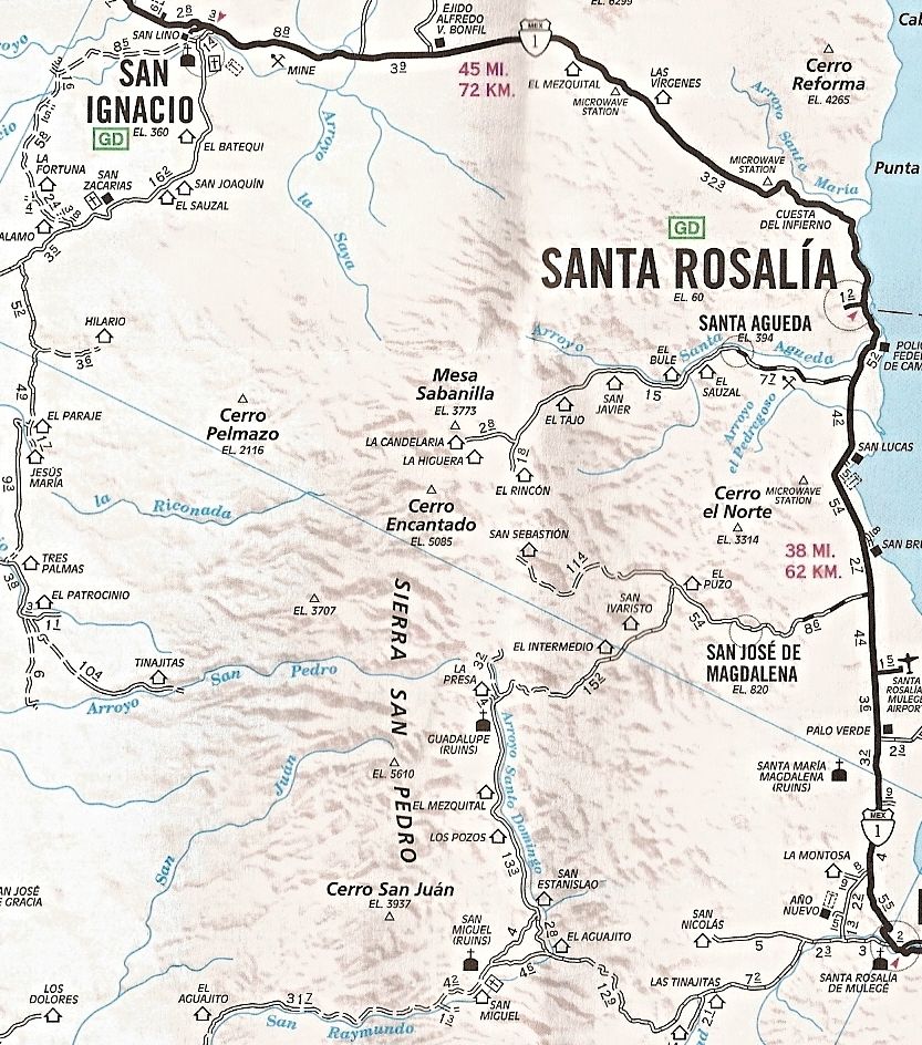
South to La Purísima
Since you are interested in getting to Loreto along El Camino Real from Mulegé, check out these maps. Nomad KurtG has driven a Ford Explorer (I think)
on the road from Mulegé to Paso Hondo and on to La Purísima/San Isidro.
Many Nomads have used the 'new' road (next to the blue arrow) I added in as a dashed line...
[Edited on 11-25-2016 by David K]
|
|
|
David K
Honored Nomad
Posts: 65588
Registered: 8-30-2002
Location: San Diego County
Member Is Offline
Mood: Have Baja Fever
|
|
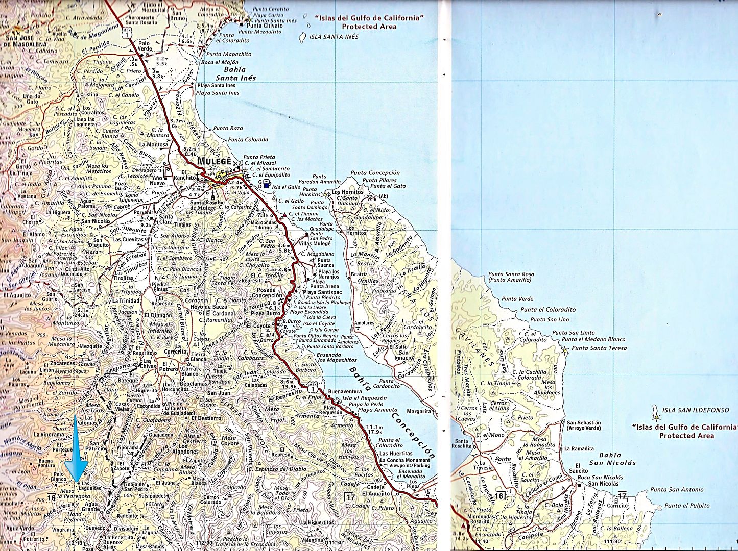
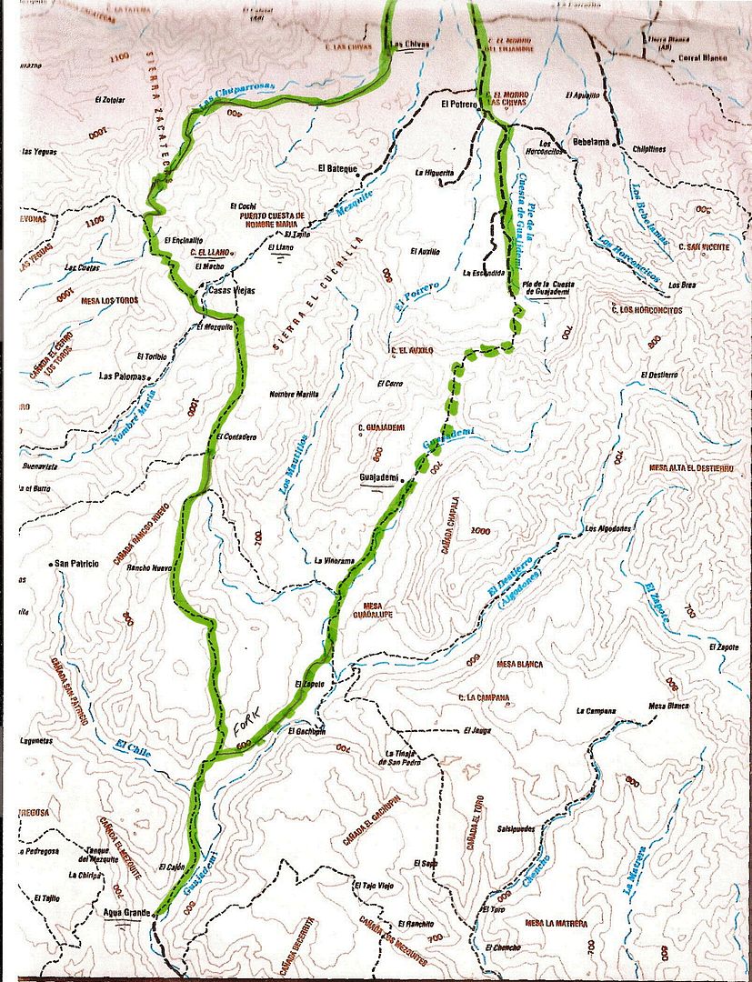
Mulegé to Loreto... the hard way!
Map 1
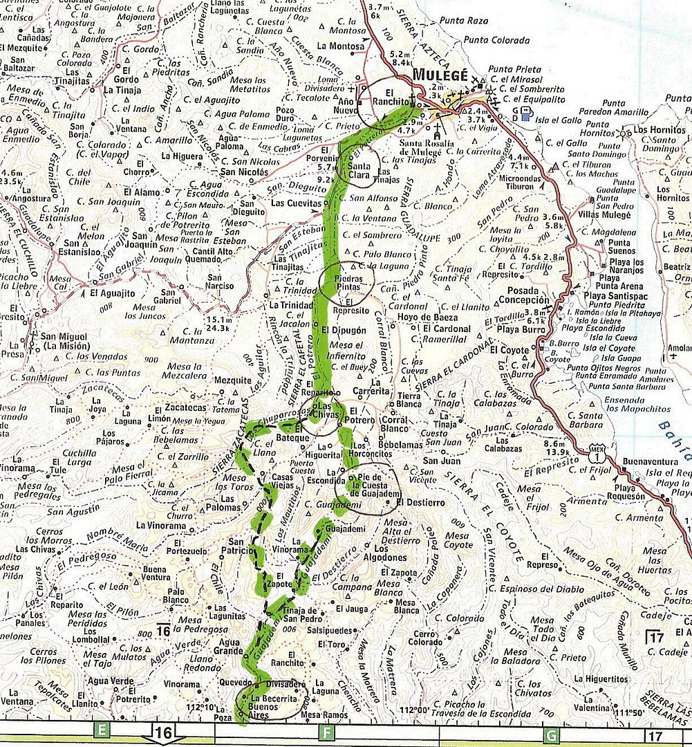
Dashed lines on above map: The new auto road is the west fork from Las Chivas up and the Camino Real is the east fork via Guadajemi.
On the following maps: Dashed line is trail (El Camino Real from the 1700s) and solid line is 4x4 or truck roads....
Close Up of Guadajemi Trail and bypass road:
Map 2
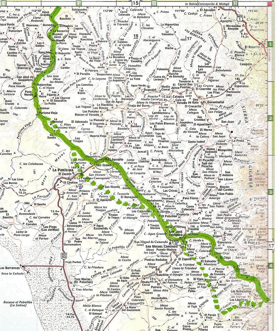
The dashed line is the Camino Real mission road where it is different than newer automobile roads.
Map 3
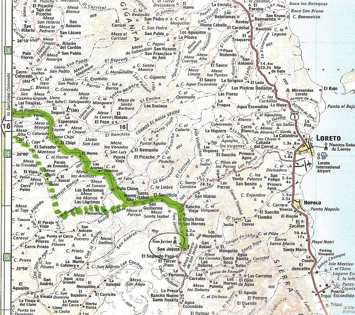
The road is paved between Loreto and San Javier. The above maps are the 2009 Baja Almanac and the close-up map of the bypass road is the older, but
larger scale Baja Topo Atlas from the 1980s and 90s.
[Edited on 11-25-2016 by David K]
|
|
|
TMW
Select Nomad
Posts: 10659
Registered: 9-1-2003
Location: Bakersfield, CA
Member Is Offline
|
|
There are two trails out of Mulege to the west that make for a great loop ride/drive to Loreto.
1- looking at DKs first map Arroyo San Raymundo. It is a dirt road that goes west to the graded road along the coast to San Juanico. From there it is
paved going south to Hwy 1 or back east to La Purisima/San Isidro and out to Hwy 1 north of Loreto.
2- A more challenging route is the one going south west from La Trinidad (same map) to Paso Hondo, called the Guajademi Trail. It was an old
horse/mule trail that was graded a few years ago. It does not show up as a road on any maps that I know of. It ends at San Isidro. It is a switch back
road up over and down the mountains and one of the more fun routes in my opinion. I've been both ways in my Tacoma.
The more difficult part of either trail is finding your way out of Mulege as the rains often change the roads in the arroyo. If you can find your way
to Rancho Las Cuevitas that is the junction for both. From there it is not hard to find your way out.
There is a group now doing the San Raymundo Trail and their leader recently said the Guajademi Trail is closed thru the mountains due to the rains.
But give it a few days and it could be open.
|
|
|
Jack Swords
Super Nomad
Posts: 1097
Registered: 8-30-2002
Location: Nipomo, CA/La Paz, BCS
Member Is Offline
|
|
Wow, lots of info David. You should write a book!
Did several of these roads in past years, La Purisma Vieja is a beautiful date palm grove.
|
|
|
David K
Honored Nomad
Posts: 65588
Registered: 8-30-2002
Location: San Diego County
Member Is Offline
Mood: Have Baja Fever
|
|
Quote: Originally posted by Jack Swords  | Wow, lots of info David. You should write a book!
Did several of these roads in past years, La Purisma Vieja is a beautiful date palm grove. |
LOL...
Seriously, I have been asked to write two more... one on the El Camino Real in Baja (Harry's book is over 40 years old now, so maybe an update of some
sort)... and another on my lifetime Baja travels, perhaps the more interesting trips and adventures?
Alas, I need a big time publisher who can give me an advance!!! HA!!
[Edited on 11-25-2016 by David K]
|
|
|
TMW
Select Nomad
Posts: 10659
Registered: 9-1-2003
Location: Bakersfield, CA
Member Is Offline
|
|
David a new book on the El Camino Real would be great, especially with your maps etc. As to your Lifetime travels, as long as there are not too many
baby pictures.
|
|
|
David K
Honored Nomad
Posts: 65588
Registered: 8-30-2002
Location: San Diego County
Member Is Offline
Mood: Have Baja Fever
|
|
| Quote: Originally posted by TMW | | David a new book on the El Camino Real would be great, especially with your maps etc. As to your Lifetime travels, as long as there are not too many
baby pictures. |
I would like to help Baja Bucko or wait to see what she is doing with her many years now, riding a mule on El Camino Real. That would be fantastic and
a better replacement for Harry Crosby's work. I could do maps and how to see the mission road using 4x4s or hiking... as well as where it crosses or
is covered by modern roads (such as the Hwy. 5 near Coco's Corner).
Not one baby picture of me (I was 7 when we went to Gonzaga Bay in 1965)... maybe Chris and Sarah, who I began taking to Baja when they were babes...
about 1992?
Nuevo Mazatlan Trip
[Edited on 11-25-2016 by David K]
|
|
|
Aldervale
Junior Nomad
Posts: 95
Registered: 12-22-2013
Member Is Offline
|
|
Many thanks
Get me started with some planning.....had hoped to reach San Javier
and come out to Loreto.
Aldervale
|
|
|
David K
Honored Nomad
Posts: 65588
Registered: 8-30-2002
Location: San Diego County
Member Is Offline
Mood: Have Baja Fever
|
|
I look forward to reading more on your trip!
|
|
|
AKgringo
Elite Nomad
Posts: 6368
Registered: 9-20-2014
Location: Anchorage, AK (no mas!)
Member Is Offline
Mood: Retireded
|
|
Aldervale, what are you driving? I followed two dirt bikes over the road west from Mulege on Thanksgiving. I was driving the older version Kia
Sportage, stock except for oversize tires.
The east side of the divide is in pretty good shape, and could be done by most SUV's or light trucks, even in 2wd. Once you are down into the Arroyo,
things get ugly.
There are long stretches of no road at all, except for what looks like a single pass down the arroyo with a bull dozer! I lost count of how may water
crossing we made, and on one of them I high centered hard on a boulder!
I was able to get off it, but there is damage to my drive train or suspension somewhere that I can feel in certain conditions.
The road is more tedious than technically difficult, but it won't be fun in anything that is not running large soft tires.
By the way, the road from Mex 1 over the pass to San Isidro is also washed out pretty badly. The ranchers drive it in 2wd trucks, but it is brutal in
several sections
The road between the Commondu's and San Isdro is in very good shape for a change. I do not know about the road from San Javier to the Commondu's, but
I may drive down to Loreto in the next couple of days to check it out.
If you are not living on the edge, you are taking up too much space!
"Could do better if he tried!" Report card comments from most of my grade school teachers. Sadly, still true!
|
|
|
Aldervale
Junior Nomad
Posts: 95
Registered: 12-22-2013
Member Is Offline
|
|
Thanks AK
Your more current info is helpful
We have a more or less stock T 100 with a FWC camper shell....good tires and a pump.
We have self recovery experience but also know when to say nah to anything especially bad.
Just like getting away from the highway.
Aldervale
|
|
|
motoged
Elite Nomad
Posts: 6481
Registered: 7-31-2006
Location: Kamloops, BC
Member Is Offline
Mood: Gettin' Better
|
|
Aldervale,
I was on one of the bikes with AKGringo (Gary, a fine adventure companion !! ) and wouldn't encourage you to do it alone. It was a challenge and a
short wheelbase vehicle would be better....and it is rough going.
Don't believe everything you think....
|
|
|
Aldervale
Junior Nomad
Posts: 95
Registered: 12-22-2013
Member Is Offline
|
|
AK and Motoged
I have read that you two are experienced riders on this route....
my off road riding skills are way past plus I cannot bring a bike and the camper .....
Is there a reasonable trek westward from Ciudad Mulege that might get us over to the Pacific side and then southward ?
We are just wanting to poke around, meet folks on Ranchos and see some of the country away from 1......some cuevas pinturas and mission sites would
also be grand.
I will fine tune this as we get closer.....February....we may just head westward and then backtrack out.
You folks are very helpful with such good local info.
Aldervale
|
|
|
David K
Honored Nomad
Posts: 65588
Registered: 8-30-2002
Location: San Diego County
Member Is Offline
Mood: Have Baja Fever
|
|
The first two maps I posted for you should be ideal, and you will see mission sites too. My book, and mission web pages have the GPS for the missions.
Guadalupe is hard to spot as there is only a wall from the church left.
|
|
|
Gulliver
Senior Nomad
Posts: 651
Registered: 11-18-2013
Member Is Offline
|
|
Check your U2U
|
|
|
Mulege Canuck
Nomad
Posts: 393
Registered: 11-27-2016
Member Is Offline
|
|
I did the road last year in a F350 and a very large Bigfoot camper. We camped at an amazing spot half way next to a river with great swimming, even
fish. I plan to go there again this year for sure stay overnight and return back to Mulege. I would not recommend the second half on the west side.
The scenery is not that spectacular ( compared with the east side) and it is a field of boulders and sand. It is not worth beating your rig up in my
opinion.
We met some great rancheros up there. The dogs they use for moving the goats are amazing to watch work.
|
|
|
motoged
Elite Nomad
Posts: 6481
Registered: 7-31-2006
Location: Kamloops, BC
Member Is Offline
Mood: Gettin' Better
|
|
Tom,
The Guajademi Trail has been closed by two rockslides that left the route presently unpassable by boulder rockslides that a local moto racer says one
would have to lift their moto over (Trials type riding)...no word on when it might be cleared...I was mildly disappointed but not enough to leave
AKGringo and Bailey out of a potential section if Dave and I tried it. I am skeptical that it will be cleared "in a few days" as it appears to have
been out of commission since the last big rains here ( a few months ago?).
The west end of the Arroyo San Raymundo has a ranch that looks like it is likely Rancho Dolores on the AAA map DK provided above...for at least past 8
years there has been a road to Ejido Cadaje that cuts south from Dolores to Arroyo San Martin and out at Ejido Cadaje....the Ballena - Dolores road
appeared much less used ...
| Quote: Originally posted by TMW | There are two trails out of Mulege to the west that make for a great loop ride/drive to Loreto.
1- looking at DKs first map Arroyo San Raymundo. It is a dirt road that goes west to the graded road along the coast to San Juanico. From there it is
paved going south to Hwy 1 or back east to La Purisima/San Isidro and out to Hwy 1 north of Loreto.
2- A more challenging route is the one going south west from La Trinidad (same map) to Paso Hondo, called the Guajademi Trail. It was an old
horse/mule trail that was graded a few years ago. It does not show up as a road on any maps that I know of. It ends at San Isidro. It is a switch back
road up over and down the mountains and one of the more fun routes in my opinion. I've been both ways in my Tacoma.
The more difficult part of either trail is finding your way out of Mulege as the rains often change the roads in the arroyo. If you can find your way
to Rancho Las Cuevitas that is the junction for both. From there it is not hard to find your way out.
There is a group now doing the San Raymundo Trail and their leader recently said the Guajademi Trail is closed thru the mountains due to the rains.
But give it a few days and it could be open.
|
Don't believe everything you think....
|
|
|


