| Pages:
1
2 |
PaulW
Ultra Nomad

Posts: 3113
Registered: 5-21-2013
Member Is Offline
|
|
InReach/Earthmate
You that are using InReach in Baja give us your review of the map quality and completeness for the Earthmate map that is included with the InReach
subscription.
So far I have been using them in the states in The San Juans and for travels along the high ways and wow I am very impressed. I have the app in my
tablet and my phone so far. Tablet is best due to size.
Thanks, PW
|
|
|
WestyWanderer
Nomad
Posts: 284
Registered: 10-24-2014
Location: San Clemente, CA
Member Is Offline
|
|
Paul,
DK will have better info because I know he has used one extensively lately, but we just got an explorer and used it on our last trip and was happy
with it. It definitely doesn't have all roads, just main ones. We built a route at home on the computer and then uploaded it to the unit complete with
waypoints for turns and that worked great.
|
|
|
David K
Honored Nomad
Posts: 65587
Registered: 8-30-2002
Location: San Diego County
Member Is Offline
Mood: Have Baja Fever
|
|
I like the maps and I have posted several of my track maps from the DeLorme website.
What I don't like and have yet to learn a solution (would love to have one) is the frequent 'straight lines' between random track or message points
that overfly the actual road traveled track lines.
The Erathmate map is an app on my cell phone that connects with the InReach device with all tracks, routes, and waypoints so that I have on my inReach
is also on my cell phone.
My cell phone continues to be a live map/GPS even without the inReach device connected to it (via Bluetooth). The map is slightly different but
similar.
The DeLorme map, online, lets you switch from topo map to satellite map. That way, I can pre-mark waypoints and roads I want to visit before my trip
and they then appear on the inReach screen and the Earthmate cell phone app.
Here is the La Paz region topo map with my August track:
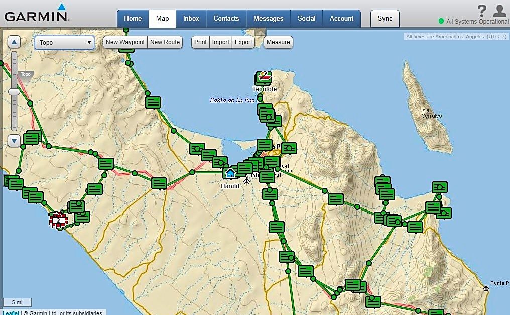
Here is the same but switched to "Aerial" from "Topo":
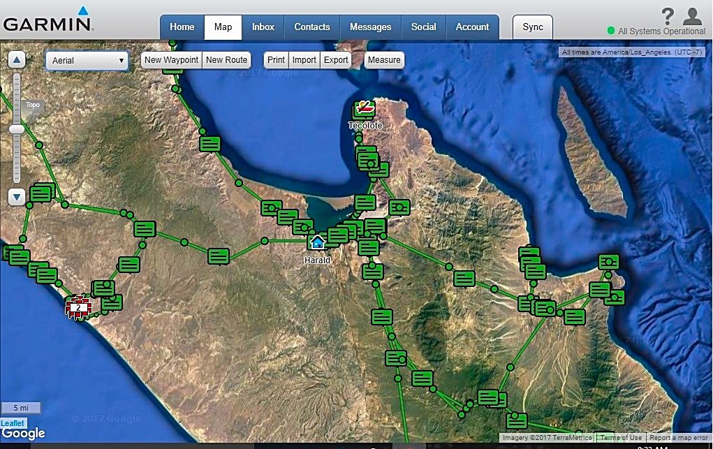
Now, one thing I don't (yet) understand is why I sometimes get a very detailed track (which I like) showing the exact road location as well as another
track flying over that connects 10-minute sending points. This was just one trip to Punta Marquez, not two.
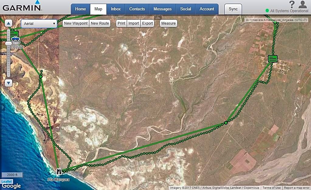
Most of the maps I zoom in on have just the 10-minute track points and not the 1 minute. The inReach is set to 1 minute, and I have never changed the
setting, yet I get this dual track line. In addition, and more irritating is the random straight lines connecting very distant points, mostly from
message sending locations (the square red boxes)???
I would love some help on how to fix that issue! Thank you!!
Anyway, I hope the images help show the mapping from the inReach device, as it looks on you home computer, after your trip!
|
|
|
ehall
Super Nomad
Posts: 1906
Registered: 3-29-2014
Location: Buckeye, Az
Member Is Offline
Mood: It's 5 o'clock somewhere
|
|
That double track is weird. Mine is set at 10 minutes and I don't get that.
|
|
|
ehall
Super Nomad
Posts: 1906
Registered: 3-29-2014
Location: Buckeye, Az
Member Is Offline
Mood: It's 5 o'clock somewhere
|
|
The map is about the same as Google Earth
|
|
|
mtgoat666
Platinum Nomad
Posts: 21152
Registered: 9-16-2006
Location: San Diego
Member Is Offline
Mood: Hot n spicy
|
|
there are 2 tracks, one for logging, one for sending. you need to go into options and filters, and choose what to show.
|
|
|
David K
Honored Nomad
Posts: 65587
Registered: 8-30-2002
Location: San Diego County
Member Is Offline
Mood: Have Baja Fever
|
|
Quote: Originally posted by mtgoat666  | | there are 2 tracks, one for logging, one for sending. you need to go into options and filters, and choose what to show. |
No such option or I just don't see it. I can delete single messages (on the device, but not the website) or entire day's worth of messages and
tracks...
The goal is to eliminate the fly-over track lines to/from message points that distract from the track line of the road or trail I was on.
Here is a good straight line example>>>
|
|
|
PaulW
Ultra Nomad
Posts: 3113
Registered: 5-21-2013
Member Is Offline
|
|
The question is about Earthmate without the InReach stuff.
Turn off your InReach and study the map and tell us the quality and detail. My question is not about the InReach straight lines posted.
With the InReach on you clutter up the map with the garbage lines the InReach creates and the result is you cannot see or understand the map. A
feature that deletes the InReach tracks after they are saved would make it a lot better to share. That is without the duplicate tracks.
BTW. I have been using Earthmate sans Inreach for travels in the Colorado mountains and I sure like what I view and follow as I drive. Hoping Baja
will be as good?
Who is using the Earthmate track feature? I have not figured it out, but supposedly you get all the breadcrumbs for your track.
|
|
|
ehall
Super Nomad
Posts: 1906
Registered: 3-29-2014
Location: Buckeye, Az
Member Is Offline
Mood: It's 5 o'clock somewhere
|
|
If the inreach owner sets it up on the website only the current track is shown. It can also be setup to show every track ever made with the inreach.
You have been able to use the earthmate app by preloading the maps?
|
|
|
David K
Honored Nomad
Posts: 65587
Registered: 8-30-2002
Location: San Diego County
Member Is Offline
Mood: Have Baja Fever
|
|
Paul, I have my cell phone on and am looking at the Earthmate map over Baja. It has all my waypoints (same symbols as the inReach map), and blue
message boxes as the inReach map has, as well as some of the track points, which show as yellow dots. Track lines are not shown, so it is cleaner
looking than the online map (which I can change to drop the lines). The map has topo lines but they show best when zoomed in. It shows major arroyos,
in blue.
I do not see any way to email the map I see to post here... Any help on how to save and send the phone screen image?
|
|
|
PaulW
Ultra Nomad
Posts: 3113
Registered: 5-21-2013
Member Is Offline
|
|
I have a similar picture on my phone. Doing the screen capture is on my to do list. Here is a starting place
| Quote: Originally posted by David K | Paul, I have my cell phone on and am looking at the Earthmate map over Baja. It has all my waypoints (same symbols as the inReach map), and blue
message boxes as the inReach map has, as well as some of the track points, which show as yellow dots. Track lines are not shown, so it is cleaner
looking than the online map (which I can change to drop the lines). The map has topo lines but they show best when zoomed in. It shows major arroyos,
in blue.
I do not see any way to email the map I see to post here... Any help on how to save and send the phone screen image? |

|
|
|
PaulW
Ultra Nomad
Posts: 3113
Registered: 5-21-2013
Member Is Offline
|
|
Simple with my Android tablet
Shown with no GPS lock - indoors

|
|
|
David K
Honored Nomad
Posts: 65587
Registered: 8-30-2002
Location: San Diego County
Member Is Offline
Mood: Have Baja Fever
|
|
Would you mind telling me the steps, my phone is an Android.
|
|
|
PaulW
Ultra Nomad
Posts: 3113
Registered: 5-21-2013
Member Is Offline
|
|
With my Tablet
press volume and power at the same time. Then go to your album and look for screen shots. No luck then do it over and hold the buttons longer. Keep
trying until you get the touch.
Then send an email to yourself with your picture. When you get the email on your computer make a screen shot and save to desktop and then transfer to
the forum message.
I noticed for what is posted the color was faded quite a bit.
If you have Gps lock you get the blue line from one of your trails like you mentioned prevously.
|
|
|
David K
Honored Nomad
Posts: 65587
Registered: 8-30-2002
Location: San Diego County
Member Is Offline
Mood: Have Baja Fever
|
|
Paul, I have a Samsung Galaxy S5.
Sounds like I need to find out how to capture a "screen shot"?
I know how to take it from email to posting on Nomad... It is the first part (capturing the screen image to email) that I haven't done.
Thanks.
|
|
|
mtgoat666
Platinum Nomad
Posts: 21152
Registered: 9-16-2006
Location: San Diego
Member Is Offline
Mood: Hot n spicy
|
|
| Quote: Originally posted by David K | Paul, I have a Samsung Galaxy S5.
Sounds like I need to find out how to capture a "screen shot"?
I know how to take it from email to posting on Nomad... It is the first part (capturing the screen image to email) that I haven't done.
Thanks. |
DK, have you heard of Google? 10 seconds to google the answer:
Here's how to do it:
Get the screen that you want to capture ready to go.
Simultaneously press the power button and the home button. ...
You'll now be able to see the screenshot in the Gallery app, or in Samsung's built-in "My Files" file browser.
Woke!
Hands off!
“Por el bien de todos, primero los pobres.”
“...ask not what your country can do for you – ask what you can do for your country.” “My fellow citizens of the world: ask not what America
will do for you, but what together we can do for the freedom of man.”
Pronoun: the royal we
|
|
|
woody with a view
PITA Nomad
Posts: 15940
Registered: 11-8-2004
Location: Looking at the Coronado Islands
Member Is Offline
Mood: Everchangin'
|
|
And, if any of you heathens graduate to an iPhone the process is identical. 
|
|
|
David K
Honored Nomad
Posts: 65587
Registered: 8-30-2002
Location: San Diego County
Member Is Offline
Mood: Have Baja Fever
|
|
| Quote: Originally posted by mtgoat666 | | Quote: Originally posted by David K | Paul, I have a Samsung Galaxy S5.
Sounds like I need to find out how to capture a "screen shot"?
I know how to take it from email to posting on Nomad... It is the first part (capturing the screen image to email) that I haven't done.
Thanks. |
DK, have you heard of Google? 10 seconds to google the answer:
Here's how to do it:
Get the screen that you want to capture ready to go.
Simultaneously press the power button and the home button. ...
You'll now be able to see the screenshot in the Gallery app, or in Samsung's built-in "My Files" file browser.
|
That's exactly what I was going to do when I got home. Thank you for the excellent answer. It works!
|
|
|
David K
Honored Nomad
Posts: 65587
Registered: 8-30-2002
Location: San Diego County
Member Is Offline
Mood: Have Baja Fever
|
|
Earthmate Maps
Here is what Gonzaga Bay area looks like on my phone with the inReach data I have collected:
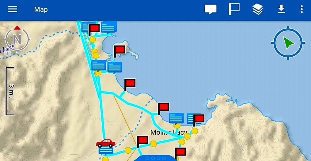
You can zoom in or out, a lot more topo data and arroyo names appear when you zoom in.
My data on the maps are
Waypoints (red flags): Papa's road jcn., Alfonsina's, Beluga, Sacrificio, Punta Final Resort, cross road, Molino de Lacy (just below map).
Message entries (blue boxes): Papa's Restaurant, his camping beach, Rancho Grande market and beach, where I camped between Sacrificio and Punta Final.
The car symbol is the roadside rest and view point at the bridge over Arroyo Santa María (that they call Arrastras).
The blue lines are my driving tracks. The yellow dots are track points. A few lines are those irritating flyovers I talked about before.
Here is how it looks when the phone is held in the normal way...
[Edited on 9-14-2017 by David K]
|
|
|
PaulW
Ultra Nomad
Posts: 3113
Registered: 5-21-2013
Member Is Offline
|
|
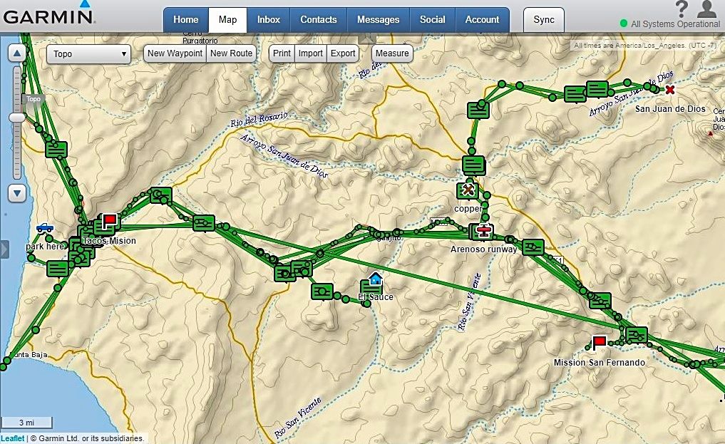
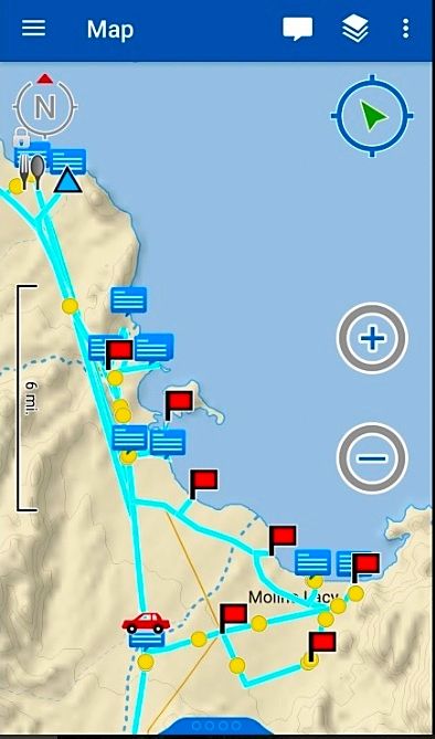
Well big disappointment there are no secondary roads shown on Earthmate. The Gonzaga screen shot below is close to the same as David's above. Zooming
in does not show data than shown in the pic.
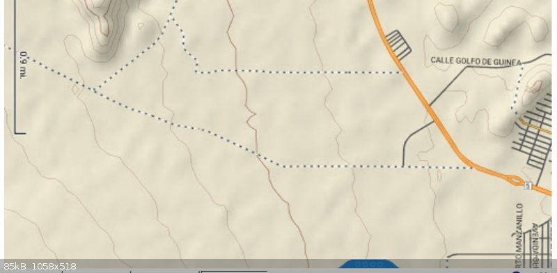
The next pics are for San Felipe. Somewhat better. Zooming in reveals some dirt roads both abandoned and currently used roads. Zooming around I find
little detail and nothing in the washes. The coast roads are minimal, with no labels.
So the search continues to find good maps for Baja for use with the tablet/phone. My present solution is keep the GPS and use Murdock. Then use
Earthmate/InReach at the same time to allow communication.


|
|
|
| Pages:
1
2 |


