David K
Honored Nomad
        
Posts: 65408
Registered: 8-30-2002
Location: San Diego County
Member Is Offline
Mood: Have Baja Fever
|
|
2018 Map: Route of Highway 1 vs. El Camino Real: Loreto to El Rosario
Hello, I wanted to share the beginnings of a new map that shows the location of El Camino Real, including a few parallel trails and mission roads,
from Loreto north to El Rosario. These trails were developed from 1699 to 1774 (for reaching the missions of San Javier to El Rosario).
El Rosario north to San Diego, ECR (El Camino Real) is closely matched by Mexico Highway #1. However, from El Rosario south to Loreto, much of the
route is very different than the road made for automobiles.
The mission road is still very visible today on the ground or in satellite images, especially from San Borja south to San Javier where vegetation does
not conceal it or modern construction has not obliterated it.
North from San Borja, the road is little more than a path that is difficult to see because the Franciscans and Dominicans, who replaced the Jesuits,
were not interested in building a "King's Highway" to the same standards as the Jesuits had.
Where the mission road location was in question, we have had the research of Howard Gulick who in 1954 made notes and maps of where he found it, or
was informed by locals, or writings of early travelers, about the route.
Utilizing Gulick's notes and maps was Harry Crosby who was hired to photograph the trail from Loreto north in the 1960s, 200 years after Junípero
Serra traveled north to San Diego from Loreto. Crosby produced his own book in 1974, the King's Highway in Baja California. In 1977, Crosby had higher
detailed maps of the mission road network made as interest was high following his 1974 book.
We still did not have all of the pieces connected with total confidence. That has all changed this past month with the 18 years of backpacking and GPS
mapping of the road by Kevin and Genevieve: http://caminorealbaja.com/
Their work and the Facebook photos and videos currently being posted by Edie Littlefield Sundby (author of The Mission Walker) of her El Camino walk
& muleback ride have raised fresh interest in the first road in Baja! https://www.facebook.com/TheMissionWalker/
The Google Earth map they have produced is very detailed. I highly recommend it for those who want to see the entire route from Loreto to El Rosario.
However, for a less detailed look, I have completed the track line using satellite images and transferred to a map that doesn't need downloading or
messing with timelines for the armchair explorer and history enthusiast.
These maps are NOT done, I will be adding more details, such as springs along the way that were vital. Just giving you an early look as this part was
the most time consuming for me...
I will post these from north to south, the opposite of the direction it was built, so they are easier to view, overall.
El Camino Real and Highway One
I am revising these maps that include waterholes and visitas along ECR. Once all 8 are updated, I will replace these 8 maps with them...
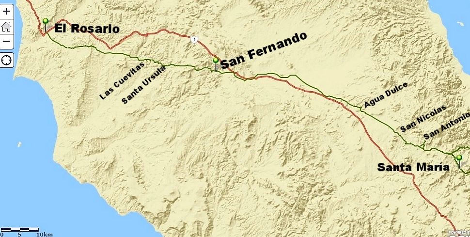
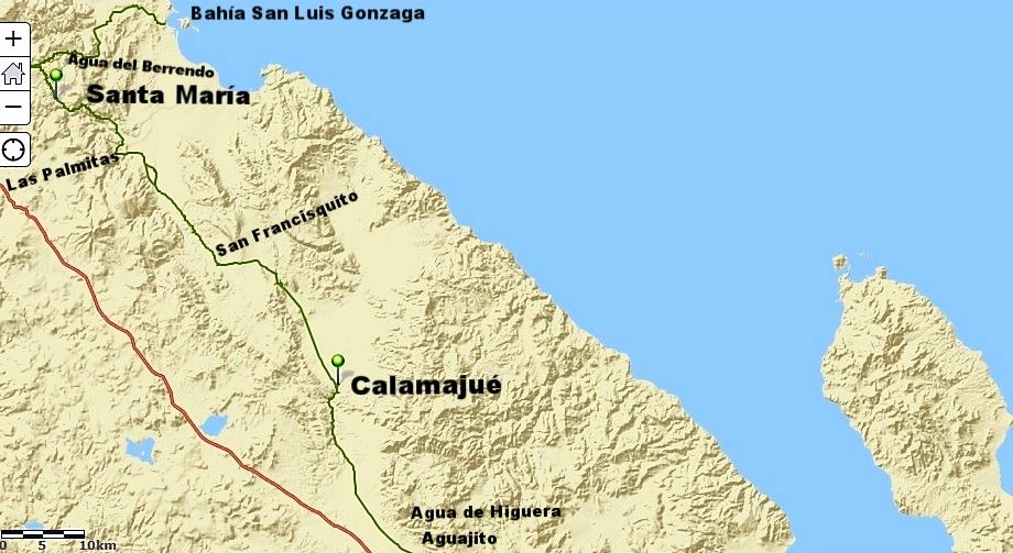
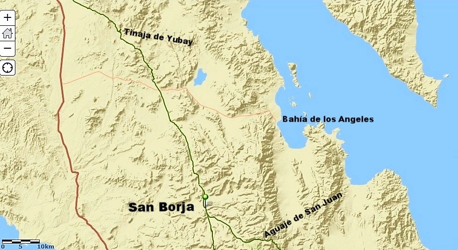
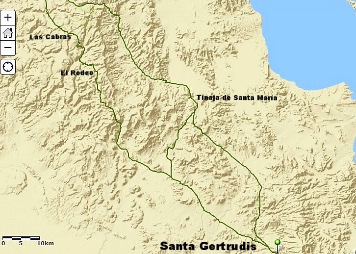
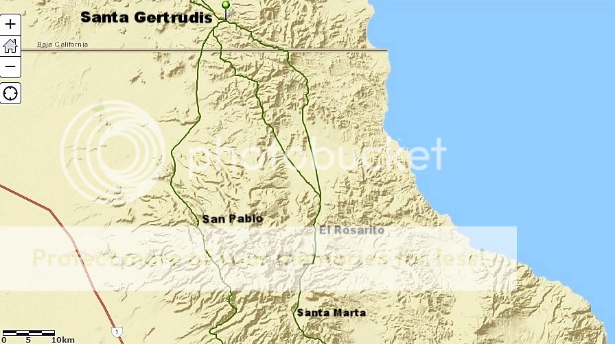
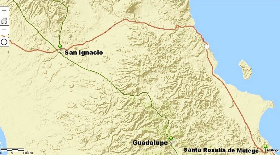
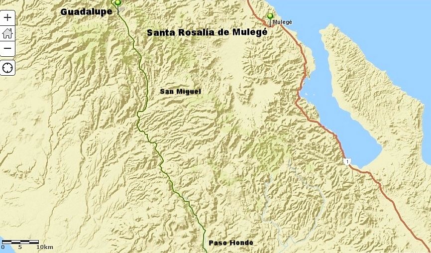
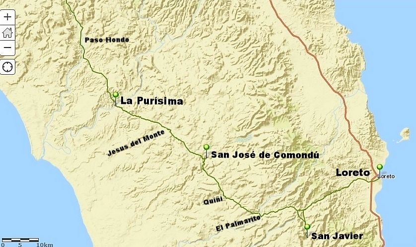
As I refine these or change them over time, I will update them.
[Edited on 4-6-2018 by David K]
|
|
|
gueribo
Nomad
 
Posts: 469
Registered: 10-16-2014
Member Is Offline
|
|
This is great.
|
|
|
TacoFeliz
Nomad
 
Posts: 268
Registered: 7-22-2005
Location: Here
Member Is Offline
Mood: Exploratory
|
|
Nice work David
|
|
|
David K
Honored Nomad
        
Posts: 65408
Registered: 8-30-2002
Location: San Diego County
Member Is Offline
Mood: Have Baja Fever
|
|
Thanks... this is only the first step.
|
|
|
Cielomar
Junior Nomad

Posts: 71
Registered: 12-5-2010
Member Is Offline
|
|
Its interesting that the original El Camino Real took a much more mountainous and inland route. I'm assuming they did so because of the availability
of springs rather than the flatness of the route. Perhaps following game and/or indigenous trails. Anyone who has driven the length of the Baja can
appreciate the historical value of this work. thanks....
|
|
|
David K
Honored Nomad
        
Posts: 65408
Registered: 8-30-2002
Location: San Diego County
Member Is Offline
Mood: Have Baja Fever
|
|
Quote: Originally posted by Cielomar  | | Its interesting that the original El Camino Real took a much more mountainous and inland route. I'm assuming they did so because of the availability
of springs rather than the flatness of the route. Perhaps following game and/or indigenous trails. Anyone who has driven the length of the Baja can
appreciate the historical value of this work. thanks.... |
El Camino Real in California connected the missions, which were located where water and people were. Between the missions it went from water hole to
water hole. That also was mainly in the mountains. Missionaries and soldiers traveled on horse or muleback.
As I update these maps, I plan on adding the important water holes and visitas along the way.
|
|
|
David K
Honored Nomad
        
Posts: 65408
Registered: 8-30-2002
Location: San Diego County
Member Is Offline
Mood: Have Baja Fever
|
|
Major water sources included...

|
|
|
David K
Honored Nomad
        
Posts: 65408
Registered: 8-30-2002
Location: San Diego County
Member Is Offline
Mood: Have Baja Fever
|
|

|
|
|
David K
Honored Nomad
        
Posts: 65408
Registered: 8-30-2002
Location: San Diego County
Member Is Offline
Mood: Have Baja Fever
|
|

|
|
|
David K
Honored Nomad
        
Posts: 65408
Registered: 8-30-2002
Location: San Diego County
Member Is Offline
Mood: Have Baja Fever
|
|

|
|
|
David K
Honored Nomad
        
Posts: 65408
Registered: 8-30-2002
Location: San Diego County
Member Is Offline
Mood: Have Baja Fever
|
|

|
|
|
bryanmckenzie
Senior Nomad
  
Posts: 561
Registered: 9-23-2009
Location: 400 Km from Mexico Beach, Florida
Member Is Offline
Mood: Hot & humid --- not hot & dry.
|
|
Nice work David. What program / method are you using? This would be awesome to lay out the routes in Google Earth 3-D. Using lat-lon waypoints?
“Travel is fatal to prejudice, bigotry, and narrow-mindedness.”
-Mark Twain
Samuel Langhorne Clemens (November 30, 1835 – April 21, 1910)
|
|
|
David K
Honored Nomad
        
Posts: 65408
Registered: 8-30-2002
Location: San Diego County
Member Is Offline
Mood: Have Baja Fever
|
|
Quote: Originally posted by bryanmckenzie  | | Nice work David. What program / method are you using? This would be awesome to lay out the routes in Google Earth 3-D. Using lat-lon waypoints?
|
I used ArcGIS to see the trail and draw a line over it on the aerial basemap. Then I converted the base map to the one called 'Streets' (which
strangely had the best topography I thought). Where the ECR cannot be seen or which trail was known by me, I utilized Kevin's new Google Earth ECR
map: http://caminorealbaja.com/ (which I sent you the link to a while ago).
|
|
|
David K
Honored Nomad
        
Posts: 65408
Registered: 8-30-2002
Location: San Diego County
Member Is Offline
Mood: Have Baja Fever
|
|
Not much more work on these since my last post. There wasn't much to add between Guadalupe and San Ignacio, other than modern ranchos.
I suppose if I put a highlight line for the El Camino Real on Baja Almanac maps, it may be even more interesting? I did that when I attempted to show
it from Google Earth images, back in 2009. With Kevin's work on the ground and his desire for authentic mission trails and not newer, ranch trails, I
am much happier knowing the correct route.
|
|
|

