| Pages:
1
2 |
Nikno
Junior Nomad

Posts: 90
Registered: 7-12-2019
Member Is Offline
|
|
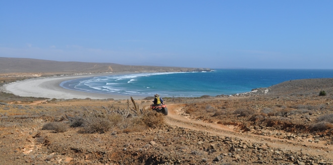
Does anyone recognize this beach?
I found this picture on a blog about coastal conservation. The caption states that it is called "Bahia El Huatamote" and that it is on the west coast
of Valle de los Cirios. That would imply somewhere between El Rosario and Guerrero Negro.
Here is a link to the article with some other beautiful photos:
https://blogcostasalvaje.com/category/valle-de-los-cirios/
Who recognizes this beach? I can't find anything by that name nor are there many bays on the Pacific coast that have this shape. The closest I have
come up with is Punta Cono.
There is a town near Loreto called Huatamote but that is not near the coast nor in Valle de los Cirios. And there is a river just south of San Felipe
called Huatamote, but again it can't be near there.

|
|
|
JZ
Select Nomad
      
Posts: 13612
Registered: 10-3-2003
Member Is Offline
|
|
Looks like somewhere in the seven sisters.
|
|
|
KurtG
Super Nomad
   
Posts: 1211
Registered: 1-27-2004
Location: California Central Coast
Member Is Offline
Mood: Press On Regardless!!
|
|
It is, I have a pic from that same spot but no notes or memory of exactly where.
|
|
|
David K
Honored Nomad
        
Posts: 65407
Registered: 8-30-2002
Location: San Diego County
Member Is Offline
Mood: Have Baja Fever
|
|
Seems like everyone who drives along the distant Pacific ( Seven Sisters) coastal road takes a photo there! It could be yet another documentation
point showing if the sea level changed?
|
|
|
SFandH
Elite Nomad
     
Posts: 7431
Registered: 8-5-2011
Member Is Offline
|
|
Yup, the above photo shows precisely the level of the sea. 
|
|
|
BooJumMan
Senior Nomad
  
Posts: 929
Registered: 8-11-2007
Location: San Diego
Member Is Offline
|
|
Spent many weeks there growing up... It is indeed called El Huatamote by the local fishermen.
In that pre-Google Earth and social media epoch, The Code was adhered to. It was based on a simple verity: if a locale had been transformational for
you, and you had put the hard yards in to get there and to learn it, to know it, why in god�s name would you broadcast the news, thus ruining the
future experience not only for yourself, but for future adventurers?
|
|
|
David K
Honored Nomad
        
Posts: 65407
Registered: 8-30-2002
Location: San Diego County
Member Is Offline
Mood: Have Baja Fever
|
|
No silly, a noticeable change... not a measurement. Having a palm tree next to the high tide line (and no waves) would help! LOL
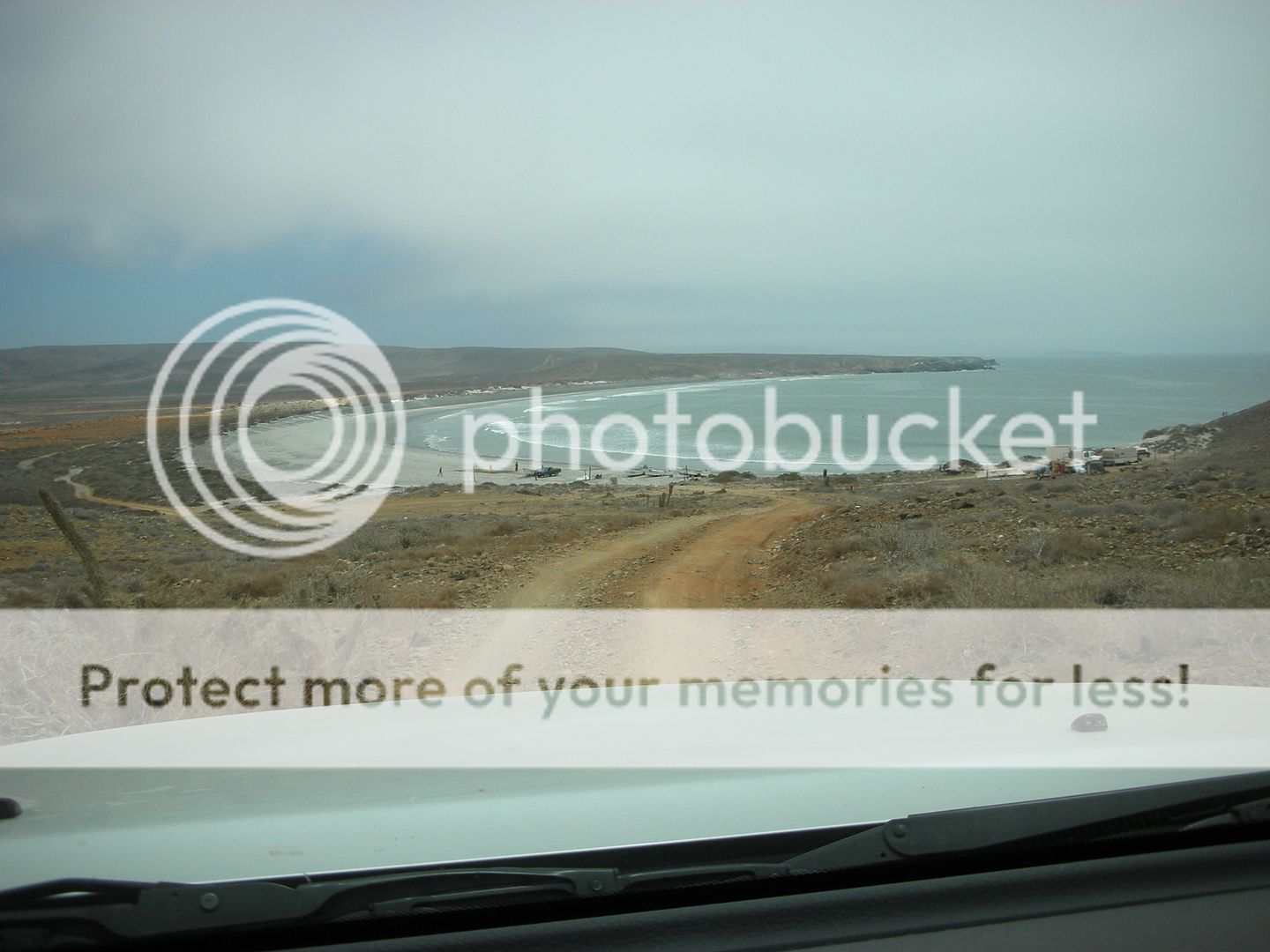
2017, was pretty gloomy in April:

2007, in July:

|
|
|
David K
Honored Nomad
        
Posts: 65407
Registered: 8-30-2002
Location: San Diego County
Member Is Offline
Mood: Have Baja Fever
|
|
Nice to know.
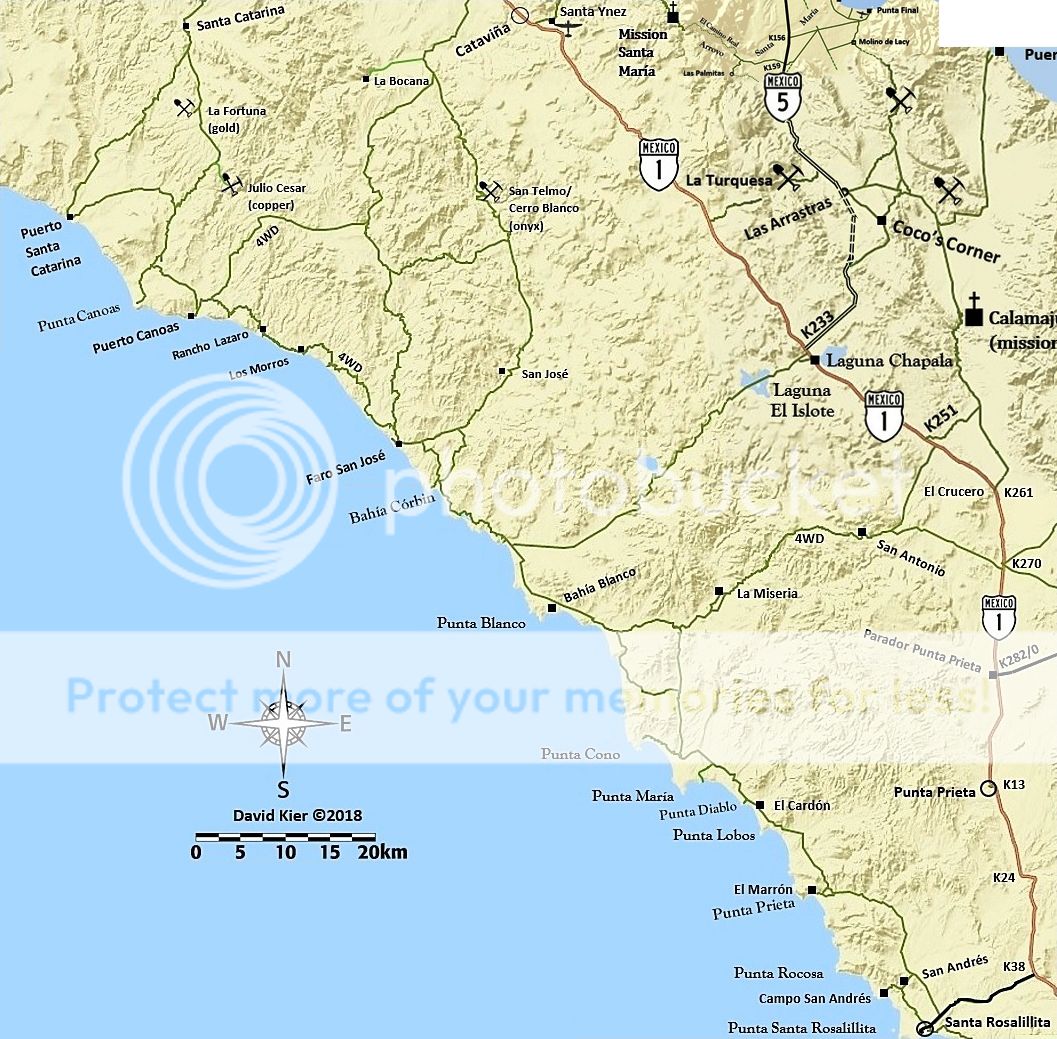
On the 2009 Baja Almanac, Map 7, it is between Bahía Córbin and Punta Vibora (between Faro San José and Punta Blanco).
On my map, it is just north of where the road from Laguna Chapala meets the coast road...

|
|
|
BajaRat
Super Nomad
   
Posts: 1304
Registered: 3-2-2010
Location: SW Four Corners / Bahia Asuncion BCS
Member Is Offline
Mood: Ready for some salt water with my Tecate
|
|
It’s the Eighth Sister Shhhhhhh
Lionel 
|
|
|
4x4abc
Ultra Nomad
    
Posts: 4454
Registered: 4-24-2009
Location: La Paz, BCS
Member Is Offline
Mood: happy - always
|
|
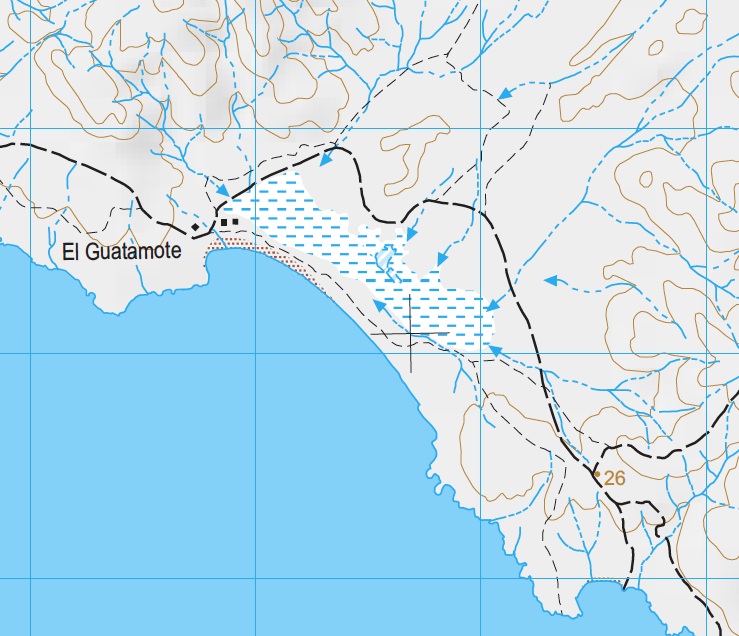
here is El Guatamote
remember that "G" in Spanish is pronounced like our "H"

Harald Pietschmann
|
|
|
SFandH
Elite Nomad
     
Posts: 7431
Registered: 8-5-2011
Member Is Offline
|
|
¿hay gansos en la playa?
There are exceptions to every rule, except, perhaps, the one just stated.

[Edited on 8-11-2019 by SFandH]
|
|
|
Nikno
Junior Nomad

Posts: 90
Registered: 7-12-2019
Member Is Offline
|
|
Thank you for all of the help! I found the exact location on Google Earth thanks to your tips. I will be doing this drive in the fall. I'll get my own
pic from there and post a trip report.
Harald, what map program are you using? I've never seen that format before.
|
|
|
larryC
Super Nomad
   
Posts: 1499
Registered: 8-11-2008
Location: BoLA
Member Is Offline
|
|
That cove is north of punta Marron and south of punta Lobos. Good clamming and surf fishing there. Good fishing at the south end off the rocks also.
[Edited on 8-11-2019 by larryC]
Off grid, 12-190 watt evergreen solar panels on solar trackers, 2-3648 stacked Outback inverters, 610ah LiFePo4 48v battery bank, FM 60 and MX60
Outback charge controllers, X-240 Outback transformer for 240v from inverters, 6500 watt Kubota diesel generator.
|
|
|
JZ
Select Nomad
      
Posts: 13612
Registered: 10-3-2003
Member Is Offline
|
|
I just had it labelled as "beach" on my maps. Fixed it up.
29° 8.088'N 114° 43.440'W
Edit: this is the correct location: 29° 12.769'N 114° 48.138'W
[Edited on 8-11-2019 by JZ]
|
|
|
David K
Honored Nomad
        
Posts: 65407
Registered: 8-30-2002
Location: San Diego County
Member Is Offline
Mood: Have Baja Fever
|
|
Harald, I think your map is of the beach further south where you go over a salt flat or around it... as your map shows. The beach in the photos is a
bay, notice the curve out to the point to the south.
|
|
|
Nikno
Junior Nomad

Posts: 90
Registered: 7-12-2019
Member Is Offline
|
|
Based on satellite imagery the beach at
29°14'26.7"N 114°50'05.3"W
makes most sense to me. David K's second pic shows a fishing camp which is visible on satellite. I think the original photo might be mislabeled. The
coordinates that JZ posted and the map Harald posted are of "El Guatamote" but this one is a few bays further north.
David K, any geo tags/gps coordinates embedded in your original pic?
|
|
|
caj13
Super Nomad
   
Posts: 1002
Registered: 8-1-2017
Member Is Offline
|
|
Quote: Originally posted by David K  | No silly, a noticeable change... not a measurement. Having a palm tree next to the high tide line (and no waves) would help! LOL
2017, was pretty gloomy in April:

2007, in July:

|
Bahahahahaaaa! hey look at that - David says his observations are superior to actual measurements, because his eyes and memory are far better than
Nasa and Noah technologies! how quaint - but it does make it easier for you to deny the facts and truth - right David!
so - like always: Dates , Times, and a tide table David! You know the drill, you spout, people hold you accountable, you fall back into your
"poor me prosecuted by evil liberals" routine!
heres some more of that claptrap spouted by a bunch of governmen t scientists, all of whom are in on the conspiracy -
Of course it's based on real measurements, so obviously its wrong!
https://oceanservice.noaa.gov/facts/sealevel.html
Oh , one more thing - watch how David will accuse me of changing the subject - because clearly - He DID NOT bring up sea level change in this
thread! Bahahahahaahaaaa
[Edited on 8-11-2019 by caj13]
[Edited on 8-11-2019 by caj13]
[Edited on 8-11-2019 by caj13]
|
|
|
4x4abc
Ultra Nomad
    
Posts: 4454
Registered: 4-24-2009
Location: La Paz, BCS
Member Is Offline
Mood: happy - always
|
|
Quote: Originally posted by Nikno  | Thank you for all of the help! I found the exact location on Google Earth thanks to your tips. I will be doing this drive in the fall. I'll get my own
pic from there and post a trip report.
Harald, what map program are you using? I've never seen that format before. |
http://internet.contenidos.inegi.org.mx/contenidos/Productos...
Harald Pietschmann
|
|
|
JZ
Select Nomad
      
Posts: 13612
Registered: 10-3-2003
Member Is Offline
|
|
Quote: Originally posted by caj13  |
Bahahahahaaaa! hey look at that - David says his observations are superior to actual measurements, because his eyes and memory are far better than
Nasa and Noah technologies! how quaint - but it does make it easier for you to deny the facts and truth - right David!
so - like always: Dates , Times, and a tide table David! You know the drill, you spout, people hold you accountable, you fall back into your
"poor me prosecuted by evil liberals" routine!
heres some more of that claptrap spouted by a bunch of governmen t scientists, all of whom are in on the conspiracy -
Of course it's based on real measurements, so obviously its wrong!
https://oceanservice.noaa.gov/facts/sealevel.html
Oh , one more thing - watch how David will accuse me of changing the subject - because clearly - He DID NOT bring up sea level change in this
thread! Bahahahahaahaaaa
|
It was a joke, this is not the thread for this nonsense. Tell us about your travels to the Seven Sisters, share a few pics maybe?
|
|
|
AKgringo
Elite Nomad
     
Posts: 6281
Registered: 9-20-2014
Location: Anchorage, AK (no mas!)
Member Is Offline
Mood: Retireded
|
|
caj13, You apparently missed this post by SF&H, who teased DK a bit!
Then David teased back with the palm tree quip, ending with lol (laugh out loud).
Are you going to follow David from thread to thread looking for something to pounce on? I don't like everything David posts, but I choose to groan
and ignore some of them, rather than turn another thread into an off topic debate! The JJJ school of journalism has moved somewhere else!
DK, you don't need to reply to every post either
[Edited on 8-11-2019 by AKgringo]
If you are not living on the edge, you are taking up too much space!
"Could do better if he tried!" Report card comments from most of my grade school teachers. Sadly, still true!
|
|
|
| Pages:
1
2 |

