| Pages:
1
2 |
PaulW
Ultra Nomad
    
Posts: 3113
Registered: 5-21-2013
Member Is Offline
|
|
Desal near San Felipe
Desalination plant will be installed in San Felipe, Baja California
Have not heard much from the proposed development?? Here is the latest.
Remember we all discussed it before with its location near Santa Maria and shell beach, just south of Percebu.
Read the press story here
https://themazatlanpost.com/2019/09/16/desalination-plant-wi...
You may recall the original plan was to obtain water from Valley Chico or from wells like the town of San Felipe use from Arroyo Huatamote. Now the
plan is to get water from beach wells – thus the need for a desal plant. Desal plants require a lot of electricity and it is mentioned that that is
an “up slope”. Nearest power line ends just north of Punta Estrella. A distance of about 20 km? Wow, that powerline will be a really big deal for
the many homes and businesses just 5 Km south of the new resort. (provided they can fund the short power line extension).
Ah yes Progress.
|
|
|
David K
Honored Nomad
        
Posts: 65430
Registered: 8-30-2002
Location: San Diego County
Member Is Offline
Mood: Have Baja Fever
|
|
It's an old story rehashed by some writer...
The project was announced in 2013 (or maybe earlier?) and they drilled a well or two at the edge of the salt flat (mud flat) east of Km. 28 (between
Shell Island road and Bahía Santa María road.
The desal plant is not for San Felipe use but for this far-out marina and golf course housing plan. To dredge there with the drifting sand, 20-30 foot
tide change, and all that cost for a marina that will be filled with sand in short order (La Salina and Santa Rosalillita, are two examples with much
smaller tides).
One good chubasco will mess it all up too.
In any case, the environmenatists won't okay it.
|
|
|
StuckSucks
Super Nomad
   
Posts: 2372
Registered: 10-17-2013
Location: Pacific Plate
Member Is Offline
|
|
January 2013:
Only 28 kilometers south from San Felipe: Marinazul Golf & Resort
|
|
|
AKgringo
Elite Nomad
     
Posts: 6303
Registered: 9-20-2014
Location: Anchorage, AK (no mas!)
Member Is Offline
Mood: Retireded
|
|
Well the post makes sense now. At first I thought Paul couldn't spell 'diesel'! 
If you are not living on the edge, you are taking up too much space!
"Could do better if he tried!" Report card comments from most of my grade school teachers. Sadly, still true!
|
|
|
PaulW
Ultra Nomad
    
Posts: 3113
Registered: 5-21-2013
Member Is Offline
|
|
Inveravante - Marinazul Golf & Resort
Yes just a summary for the goings on
Here are some Google Earth images of the area


|
|
|
David K
Honored Nomad
        
Posts: 65430
Registered: 8-30-2002
Location: San Diego County
Member Is Offline
Mood: Have Baja Fever
|
|
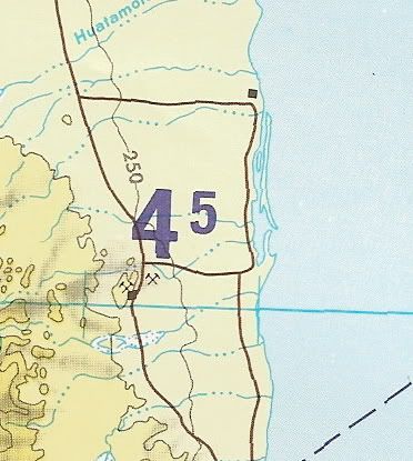
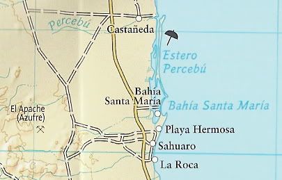
Shell Island is a better name as 'Shell Beach' is by Punta Chivato where Russ lives, plus this beach does get surrounded by water making it an
island... as shown on pilot's maps and Nat Geo agrees...
|
|
|
PaulW
Ultra Nomad
    
Posts: 3113
Registered: 5-21-2013
Member Is Offline
|
|
David, Got a chip on your shoulder today?
Any thing else you don't like what I typed?
I guess I was referring to the beach with all the shells we all like to visit. A beach does not distinguish whether it is on the mainland or on an
island.
I choose to call that strip of sand next to the Sea of Cortez as a beach.
Referring to the detail on Google Earth it is hard to distinguish an island in that location without a lot of imagination.
|
|
|
David K
Honored Nomad
        
Posts: 65430
Registered: 8-30-2002
Location: San Diego County
Member Is Offline
Mood: Have Baja Fever
|
|
No Paul, no beef... just a suggestion that a more unique name should be considered... Geologically speaking it is not just a beach, after all. Thank
you for all you do. My posts are light-hearted and never to come across as critical... I am a fun-loving guy who is into four-wheel drive, camping,
and history of Baja California.
|
|
|
mtgoat666
Platinum Nomad
       
Posts: 20533
Registered: 9-16-2006
Location: San Diego
Member Is Offline
Mood: Hot n spicy
|
|
Quote: Originally posted by David K  | Shell Island is a better name as 'Shell Beach' is by Punta Chivato where Russ lives, plus this beach does get surrounded by water making it an
island... as shown on pilot's maps and Nat Geo agrees...
|
INEGI maps show this to be Isla San Martin: http://gaia.inegi.org.mx
It is a barrier island in front of Estero Percebu.
As a barrier island it is not static, it is a dynamic landform that will shift horizontally and vertically over time. So as sea level rises, it
should shift upward and inward. No DK, the shifts cannot be measured by casual visual observation or palm tree monitoring. The shifts of such
landforms are episodic, usually primary changes occur during storms when the wind/seas move sediment around.
Woke!
Hands off!
“Por el bien de todos, primero los pobres.”
“...ask not what your country can do for you – ask what you can do for your country.” “My fellow citizens of the world: ask not what America
will do for you, but what together we can do for the freedom of man.”
Pronoun: the royal we
|
|
|
David K
Honored Nomad
        
Posts: 65430
Registered: 8-30-2002
Location: San Diego County
Member Is Offline
Mood: Have Baja Fever
|
|
The popular palm tree is not on an island and continues to be an excellent marker to compare the high tide line on a beach over nearly 90 years of
photography.
As we ALL can see*, the sea is no closer to the palm now than in the 1930s. If you are going to jump up and down saying te sea is a few centimeters
higher per science... OK, so what? It used to be hundreds of feet higher (I can show you fossil seashells in the desert). The tide raises the sea
every day by several feet. How is the length of one or two cigarettes a crisis?
*photos upon request
|
|
|
Archie
Nomad
 
Posts: 163
Registered: 4-23-2012
Member Is Offline
|
|
Quote: Originally posted by David K  | | Shell Island is a better name as 'Shell Beach' is by Punta Chivato where Russ lives, plus this beach does get surrounded by water making it an
island... as shown on pilot's maps and Nat Geo agrees... |
You know what is a better name?. Isla San Martin, since its the one recognized by the official geography authority in Mexico.

I like to think you try to stick Shell Island just to brag with your friends "hey, i named this place", but since its a geographic reference and its
already on official cartography, it would need more than 100 posts on an internet forum.
Actually it would require to be presented as a reform for the national institute for geography, statistics and informatics to actualize all its
database and references.
Once its admitted, that proposed reform will have to be substantiated legally, socially and technically, as to why the name have to be changed
Then it will have to be approved by congress and signed by the president.
and yes, i have too much free time.
[Edited on 9-25-2019 by Archie]
|
|
|
David K
Honored Nomad
        
Posts: 65430
Registered: 8-30-2002
Location: San Diego County
Member Is Offline
Mood: Have Baja Fever
|
|
I did name it, my camping place, in 1978. I think it's a great name as it fits. I am totally aware that the gringos who moved to the South Campos,
many many years after I named the place began calling it Shell Beach. Perhaps they were not even aware the spot they drove to was an island or they
just din't have a bigger imagination? It doesn't matter, I am just putting it out there (the name) in case it catches on as a better name or at least
more colorful.
About 15 years ago, there was an attempt to have a camp across the lagoon from about where I camped on the island... It was named Isla San Martin...
There was a sign on the highway for it even. The camp failed. The lagoon has no water in it during the smallest phases of the moon, so the view is of
a mud area, so not really attractive.
I also named the steep grade near Mission Santa María, 'The Widowmaker', and that has stuck. It is all in good fun, that's all.
|
|
|
PaulW
Ultra Nomad
    
Posts: 3113
Registered: 5-21-2013
Member Is Offline
|
|
I know you said 15 years ago for the San Martin sign. I bet it was earlier?
Times change in 2003 or 2004 the road to shell beach was still functional - (no sign). The bridge over the last ditch was good enough to drive across.
Now all we see is mud and a broken down bridge. As you all know the beach is still accessible by picking the dry line to avoid the mud trap.
|
|
|
David K
Honored Nomad
        
Posts: 65430
Registered: 8-30-2002
Location: San Diego County
Member Is Offline
Mood: Have Baja Fever
|
|
Quote: Originally posted by PaulW  | I know you said 15 years ago for the San Martin sign. I bet it was earlier?
Times change in 2003 or 2004 the road to shell beach was still functional - (no sign). The bridge over the last ditch was good enough to drive across.
Now all we see is mud and a broken down bridge. As you all know the beach is still accessible by picking the dry line to avoid the mud trap.
|
Yes, I was guessing about the sign, maybe more than 15 years?
However, the bridge in Feb. 2004 was not functional:

Surfer Jim on the (mostly gone) causeway road to Shell Island. Built to provide high tide access in 1984 for a development that never was started. The
concrete culvert/ bridge remains while most of the elevated roadbed has eroded away.
|
|
|
mtgoat666
Platinum Nomad
       
Posts: 20533
Registered: 9-16-2006
Location: San Diego
Member Is Offline
Mood: Hot n spicy
|
|
Dk, your attempt to rename Isla San Martin is wrong in so many ways...
Show some respect for history! The island was named by old-timers, long before you came around, and you are dishonoring the man the island was named
for (I am assuming it was named for Jose de San Martín or saint Martin de Porres Velazquez)
Why the renaming using English? You trying to colonize the island or what?
In your forthcoming road maps, how many geographic place names did you rename to satisfy your whims?
Woke!
Hands off!
“Por el bien de todos, primero los pobres.”
“...ask not what your country can do for you – ask what you can do for your country.” “My fellow citizens of the world: ask not what America
will do for you, but what together we can do for the freedom of man.”
Pronoun: the royal we
|
|
|
PaulW
Ultra Nomad
    
Posts: 3113
Registered: 5-21-2013
Member Is Offline
|
|
Shell beach bridge
Thanks for the picture and its date.
I dug out some detailed records. I crossed the bridge after Feb 2003, based on the rig I was driving when I drove over the thing. Of course I could
not have gotten over the thing as shown.
(Most likely it I was when I attended the Baja 1000 in November 2004, but I did go to the 05 race as well) I have to believe bridge modifications
occurred either before or after the picture?
In any event I remember the tall columns. As far as the sign, my memory fails because I do not remember ever seeing it.
Quote: Originally posted by David K  | Quote: Originally posted by PaulW  | I know you said 15 years ago for the San Martin sign. I bet it was earlier?
Times change in 2003 or 2004 the road to shell beach was still functional - (no sign). The bridge over the last ditch was good enough to drive across.
Now all we see is mud and a broken down bridge. As you all know the beach is still accessible by picking the dry line to avoid the mud trap.
|
Yes, I was guessing about the sign, maybe more than 15 years?
However, the bridge in Feb. 2004 was not functional:

Surfer Jim on the (mostly gone) causeway road to Shell Island. Built to provide high tide access in 1984 for a development that never was started. The
concrete culvert/ bridge remains while most of the elevated roadbed has eroded away. |
|
|
|
David K
Honored Nomad
        
Posts: 65430
Registered: 8-30-2002
Location: San Diego County
Member Is Offline
Mood: Have Baja Fever
|
|
Goat, just like Bahia Santa Maria (Aniceto Madueña's daughter is Maria), somebody made up the name Isla San Martin. The sign appeared maybe after
2000 but the road was built in 1982. I named it in 1978 but didn't make a sign or put it on my maps then... It was simply my pet name for the place. I
DON'T CARE what anyone else calls it. I am just offering a unique and fitting name for the place.
Paul: The graded then elevated road across the lagoon/ mudflats, the bridge, and the cinder block columns at Km. 26 all went in around early 1985
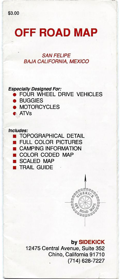
perhaps late 1984? No sign or name, however, in the 1989 folding map and guide to Off Road San Felipe by Sidekick of Chino, CA, it calls the end of
the road a campground by the name"El Pelicano". I may have missed seeing a campground of any kind but a commercial fishing camp has a hut just south
of there (where the original road reached the beach), and is seasonally occupied.
I made a post about it, just 6 months ago: http://forums.bajanomad.com/viewthread.php?tid=92534
A series of off-road maps with guide info on the back were produced by Richard Russell under the name 'Sidekick'. Here is a look at some of what was
included. The San Felipe one was two parts, printed on both sides, and folded like a brochure on heavy stock paper. On the back of the main map page
were small maps showing where Baja was, how to find the Mexicali border, crossing Mexicali and San Felipe, along with suggestions for traveling in
Mexico.
Here is the rest of the Off-Road Map and guide to driving the coast to Puertecitos, in 1989... [note: the 30-year-old map is out-of-print and no
longer available. I am sharing it here for historic maps of Baja education.]
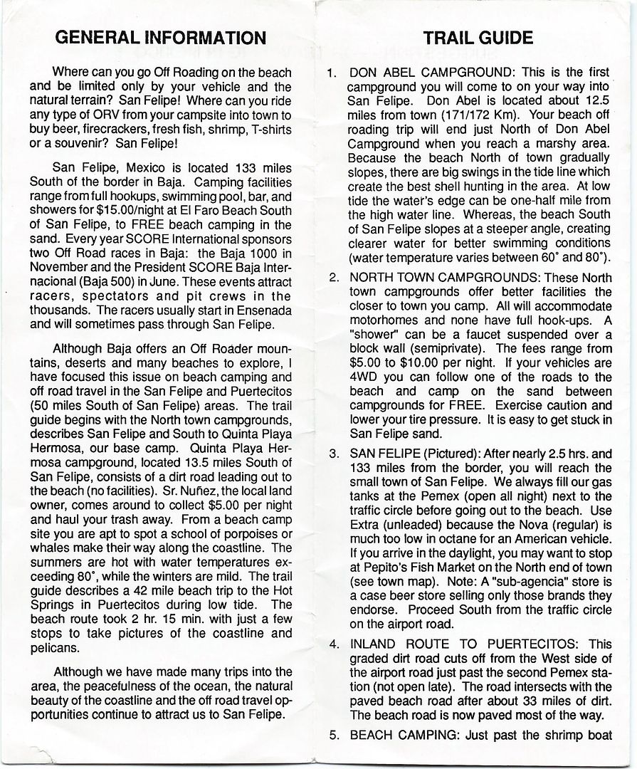
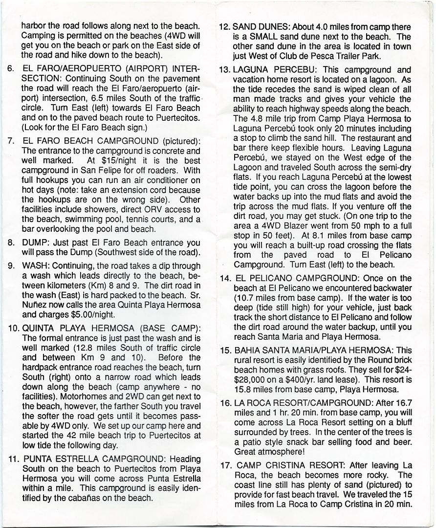
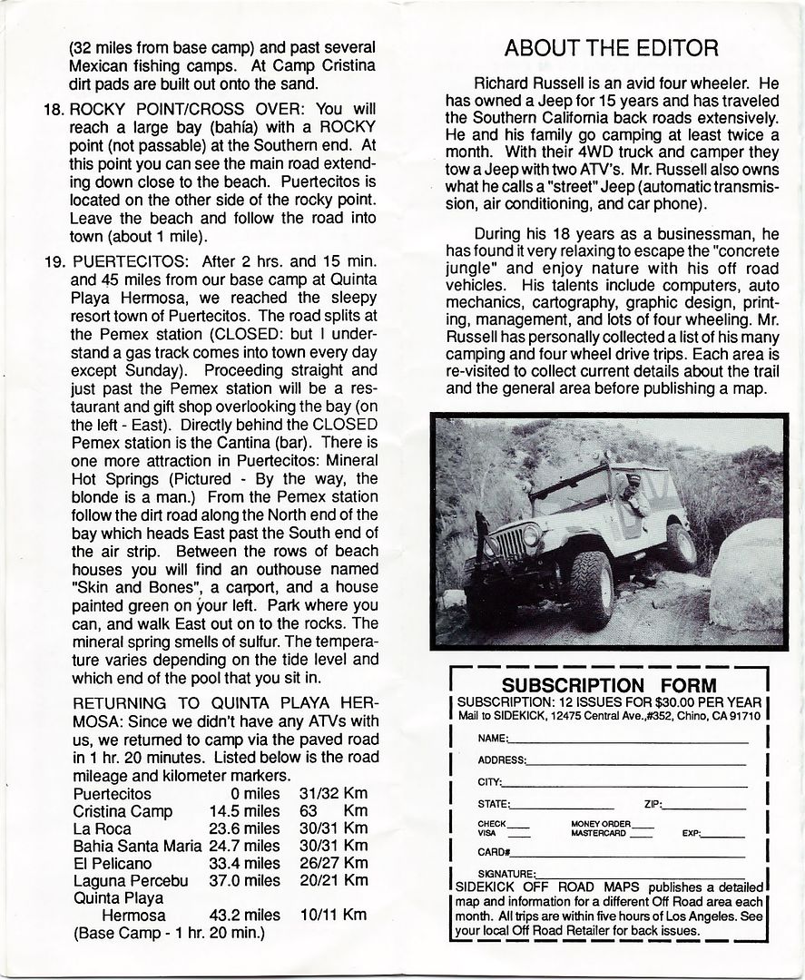
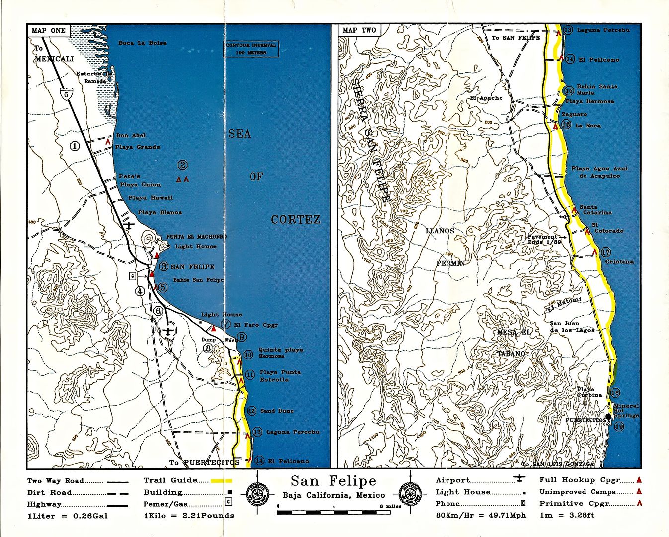
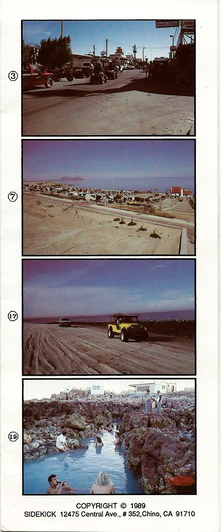
From the map:
El Pelicano was a brief attempt to have a campo on Shell Island (late 1980s).
The pavement south of San Felipe ended at El Coloradito in January 1989.
|
|
|
mtgoat666
Platinum Nomad
       
Posts: 20533
Registered: 9-16-2006
Location: San Diego
Member Is Offline
Mood: Hot n spicy
|
|
Quote: Originally posted by David K  | | Goat, just like Bahia Santa Maria (Aniceto Madueña's daughter is Maria), somebody made up the name Isla San Martin. The sign appeared maybe after
2000 but the road was built in 1982. I named it in 1978 but didn't make a sign or put it on my maps then... |
I would think a historian would learn the history and reason behind the place name before waging a print campaign to replace the name, eh?
Woke!
Hands off!
“Por el bien de todos, primero los pobres.”
“...ask not what your country can do for you – ask what you can do for your country.” “My fellow citizens of the world: ask not what America
will do for you, but what together we can do for the freedom of man.”
Pronoun: the royal we
|
|
|
David K
Honored Nomad
        
Posts: 65430
Registered: 8-30-2002
Location: San Diego County
Member Is Offline
Mood: Have Baja Fever
|
|
I gave the history of the area names... People make up names for places. It is as simple as that.
|
|
|
PaulW
Ultra Nomad
    
Posts: 3113
Registered: 5-21-2013
Member Is Offline
|
|
I don't care much about the various names. All are acceptable. It is a common thing in Mexico to have a place with many names. Good old Bruce Barber
had many place names and some of them have stuck around for a long time. Many locals have no idea when official names are used because the think
Bruce's names are official.
Never heard of El Pelicano or Shell Island, but that does not mean anything more than that I do not have enough local friends.
Thanks for the Sidekick link I guess I was traveling when it was posted.
Here is a recent example I dug up:
West at the narrows Huatamote becomes un drivable because of large steps and one must turn S-SW into Arroyo La Gringa which then becomes Parral then
Berrendo in valley Chico. (Previously based on the Almanac the turn was labeled Parral with no reference to La Gringa). Info from INEGI topo is much
less helpful
|
|
|
| Pages:
1
2 |

