| Pages:
1
2 |
LancairDriver
Super Nomad
   
Posts: 1605
Registered: 2-22-2008
Location: On the Road
Member Is Offline
|
|
Baja Map Package
Amazon has a National Geographic Map package that looks interesting. Has anyone had any experience with these, and if so do they compare with DK’s
which are excellent? The reviews from users don’t look so hot
https://www.amazon.com/gp/r.html?C=VNHG9WMHURC4&K=2RR3WF...
[Edited on 10-21-2019 by LancairDriver]
|
|
|
advrider
Super Nomad
   
Posts: 1920
Registered: 10-2-2015
Member Is Offline
|
|
I have the set and next to the atlas that you can't get any more they are very good. DK'S maps have more detail on a smaller scale if that makes
sense? They are worth having for sure.
|
|
|
bajaric
Senior Nomad
  
Posts: 675
Registered: 2-2-2015
Member Is Offline
|
|
Nat Geo maps are so so. Pretty good detail on watercourses, topography, and dirt tracks. Two major cons: One, no mileage logs between road
junctions. Two, instead of lat / long on the edge the map has weird NAD datum expressed as 34 80, 34 70 etc. Still have not figured that out. These
two things make the Nat Geo pretty much useless for navigation in the back country.
Also street map of Mexicali border crossing is out of date, but that is true for all current paper maps since they changed the crossing.
|
|
|
BajaMama
Super Nomad
   
Posts: 1108
Registered: 10-4-2015
Location: Pleasanton/Punta Chivato
Member Is Offline
Mood: Got Baja fever!!
|
|
I keep the set with my other older maps (AAA). Can't have too many maps...
|
|
|
David K
Honored Nomad
        
Posts: 65436
Registered: 8-30-2002
Location: San Diego County
Member Is Offline
Mood: Have Baja Fever
|
|
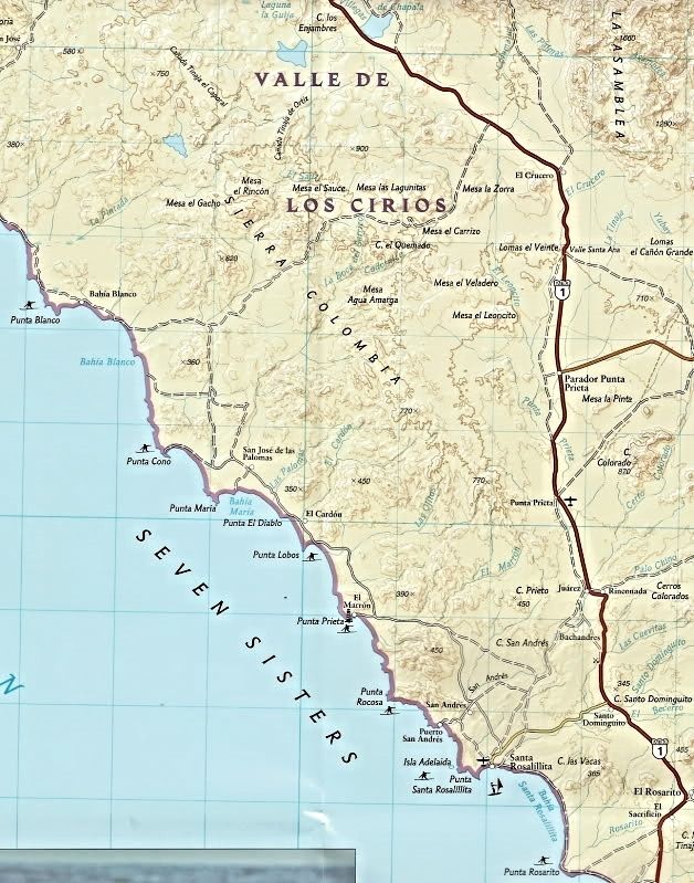
The 2008 Nat Geo maps are BIG, large scale (2 maps Norte and Sur) with half the area on one side and the other half on the other side.
That said, they are not very useful for navigation for the reasons 'bajaric' mentioned. They don't have mileages on the roads and they lack a lot of
roads that are not on the map but should be. The first printing didn't even have El Mármol on it... it did get added, however!
Now, my maps (thanks for the compliments) do not have mileages either, but that is because they go with the road guide I made. I did add mileages to
one just to see how that worked out. I still may to the others... It was just a lot of work to do, and solely for the joy of doing it...
Here is a sample of the 2008 Nat Geo map:

[Edited on 10-21-2019 by David K]
|
|
|
mtgoat666
Platinum Nomad
       
Posts: 20561
Registered: 9-16-2006
Location: San Diego
Member Is Offline
Mood: Hot n spicy
|
|
Quote: Originally posted by David K  | The 2008 Nat Geo maps are BIG, large scale (2 maps Norte and Sur) with half the area on one side and the other half on the other side.
That said, they are not very useful for navigation for the reasons 'bajaric' mentioned. They don't have mileages on the roads and they lack a lot of
roads that are not on the map but should be. The first printing didn't even have El Mármol on it... it did get added, however!
[/URL]
[Edited on 10-21-2019 by David K] |
i would think a supposed map guy would know better...   
DK, the nat geo maps are "small scale." The baja almanac maps are "large scale." 
Small scale maps of baja do not need to show locations like el marmol. Why would you fault a 1:450,000 map for omitting el marmol? 
Woke!
Hands off!
“Por el bien de todos, primero los pobres.”
“...ask not what your country can do for you – ask what you can do for your country.” “My fellow citizens of the world: ask not what America
will do for you, but what together we can do for the freedom of man.”
Pronoun: the royal we
|
|
|
pacificobob
Super Nomad
   
Posts: 2341
Registered: 4-23-2006
Member Is Offline
|
|
i find national gro maps the be printed on top quality paper, but are short on detail.
|
|
|
David K
Honored Nomad
        
Posts: 65436
Registered: 8-30-2002
Location: San Diego County
Member Is Offline
Mood: Have Baja Fever
|
|
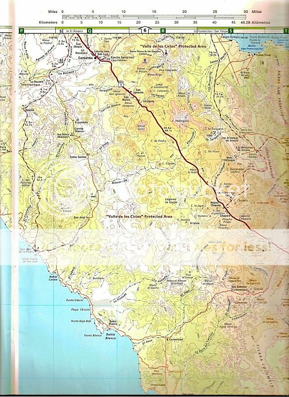
Goat says this is larger scale than Nat Geo... ?
Near the same region... on the Baja Almanac:

I actually think the Nat Geo map looks like a larger scale?
|
|
|
mtgoat666
Platinum Nomad
       
Posts: 20561
Registered: 9-16-2006
Location: San Diego
Member Is Offline
Mood: Hot n spicy
|
|
dk, you claim to be a map guy. but your grasp of terminology is tenuous. you need to go back to maps 101 and learn the difference between "small
scale" and "large scale."
Woke!
Hands off!
“Por el bien de todos, primero los pobres.”
“...ask not what your country can do for you – ask what you can do for your country.” “My fellow citizens of the world: ask not what America
will do for you, but what together we can do for the freedom of man.”
Pronoun: the royal we
|
|
|
Howard
Super Nomad
   
Posts: 2353
Registered: 11-13-2007
Location: Loreto/Manhattan Beach/Kona
Member Is Offline
Mood: I'd rather regret the things I've done than regret the things I haven't done.
|
|
Nice way to wake up, read about 2 children arguing about the definition of a Baja map.
Don't either one of you have anything better to do? If not, I feel sorry for your outlook on life.
Love, peace and tacos.
We don't stop playing because we grow old;
we grow old because we stop playing
George Bernard Shaw
|
|
|
HeyMulegeScott
Senior Nomad
  
Posts: 717
Registered: 8-25-2009
Location: Orygone/Mulege
Member Is Offline
|
|
They are worth your $18.33. When you are down in Baja and talking to someone about spots to see it's nice to be able to pull out a paper map. They are
Pacifico proof in case you spill a little Cerveza on them.
|
|
|
Mr. Bills
Nomad
 
Posts: 189
Registered: 9-10-2019
Location: Area Code 530
Member Is Offline
|
|
It is hard to beat the out-of-print AAA Baja maps. [Thanks again to John M for the 2003/2004 edition.]
Between it, the Baja Almanac, and David K's excellent maps I am confident that I can find my destinations.
|
|
|
caj13
Super Nomad
   
Posts: 1002
Registered: 8-1-2017
Member Is Offline
|
|
I use them all the time, both for navigation and planning road trips.
The plasticized paper makes em very durable. as for navigation, I have no issues , they work great, but I'm talking about staying on the roads,
not rhino runnin adventures.
|
|
|
LancairDriver
Super Nomad
   
Posts: 1605
Registered: 2-22-2008
Location: On the Road
Member Is Offline
|
|
Thanks for all the perspectives. I think I’ll splurge and order the Nat Geo set for 18 bucks. I also have the last AAA maps but they are getting a
bit worn. Look forward to DK’s maps coming out on a ruggedized material.
|
|
|
AKgringo
Elite Nomad
     
Posts: 6308
Registered: 9-20-2014
Location: Anchorage, AK (no mas!)
Member Is Offline
Mood: Retireded
|
|
And 'embiggened' too!
If you are not living on the edge, you are taking up too much space!
"Could do better if he tried!" Report card comments from most of my grade school teachers. Sadly, still true!
|
|
|
Marc
Ultra Nomad
    
Posts: 2802
Registered: 5-15-2010
Location: San Francisco & Palm Springs
Member Is Offline
Mood: Waiting
|
|
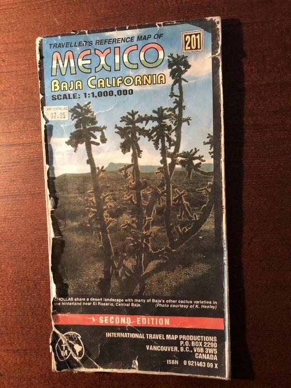
The best IMHO. Used for many years and now falling apart.

|
|
|
John M
Super Nomad
   
Posts: 1924
Registered: 9-3-2003
Location: California High Desert
Member Is Offline
|
|
Holy Cow Marc!
Put your flak vest on and by for the comments since you didn't clearly identify it as either small scale or large scale in spite of the fact it has
Scale 1:1,000,000 on its face.
John M
|
|
|
David K
Honored Nomad
        
Posts: 65436
Registered: 8-30-2002
Location: San Diego County
Member Is Offline
Mood: Have Baja Fever
|
|
Quote: Originally posted by mtgoat666  | dk, you claim to be a map guy. but your grasp of terminology is tenuous. you need to go back to maps 101 and learn the difference between "small
scale" and "large scale."
|
Where are your maps smart guy?
Where are your contributions to help travelers here?
Where are your photos to brighten the day for those seeking a dose of Baja?
You love to nag nag nag and take from us who do contribute here... but give nearly nothing of value.
The McMahan big wall maps are 1" = 14 miles, AAA maps are 1" = 11 miles, the Nat Geo maps are 1"= 7.1 miles and the Almanac is 1" = 5.5 miles.
[Edited on 10-22-2019 by David K]
|
|
|
advrider
Super Nomad
   
Posts: 1920
Registered: 10-2-2015
Member Is Offline
|
|
I'll take DK'S input all day long compared to Goats..DK, your maps in large or small scale are a huge help to travelers in Baja, I use them often.
Your passion for Baja is obvious, not sure what Goats point in being here is?
|
|
|
caj13
Super Nomad
   
Posts: 1002
Registered: 8-1-2017
Member Is Offline
|
|
Quote: Originally posted by bajaric  | Nat Geo maps are so so. Pretty good detail on watercourses, topography, and dirt tracks. Two major cons: One, no mileage logs between road
junctions. Two, instead of lat / long on the edge the map has weird NAD datum expressed as 34 80, 34 70 etc. Still have not figured that out. These
two things make the Nat Geo pretty much useless for navigation in the back country.
. |
Ric, are you referring to the blue numbers? those are UTMs. essentially a grid system covering the whole globe, uses meters, i use that all the
time to give me a quick estimate of distances, but then again I used UTMs alot when I was doing habitat mapping and modeling, so I'm familiar with
it. a lot simpler than converting degrees minutes and seconds into distances.
Another map I use for quick reference and travel is the Elimaps Baja California 2018 map. has all the gas stops camping places food tourist stops
etc. all on one page (N & S one side each). also has one of the mileage tables , also has all the dive places and shops as well. i find it
pretty handy, and easy to use
[Edited on 10-22-2019 by caj13]
[Edited on 10-22-2019 by caj13]
|
|
|
| Pages:
1
2 |

