| Pages:
1
2 |
HeyMulegeScott
Senior Nomad
  
Posts: 716
Registered: 8-25-2009
Location: Orygone/Mulege
Member Is Offline
|
|
Eastside of Bahia Concepcion
A friends Jeep trip to the eastside of Bahia Concepcion.
https://www.youtube.com/watch?v=2G88PAFQPfw
Thanks to Geoff and David K for info on the area.
|
|
|
SFandH
Elite Nomad
     
Posts: 7431
Registered: 8-5-2011
Member Is Offline
|
|
My favorite way to get to the east side of Bahia Concepcion is in my runabout, a very beachable boat. I know pretty much the entire bayside coastline,
from north to south.
There are a couple of nice coves, my favorite is near the north end. I think it's called Santa Domingo, but I'm not sure. Sailors hunker down there.
[Edited on 9-22-2021 by SFandH]
|
|
|
David K
Honored Nomad
        
Posts: 65361
Registered: 8-30-2002
Location: San Diego County
Member Is Offline
Mood: Have Baja Fever
|
|
Great to see where we couldn't get to in 2016, following the hurricane!
The same scratchy brush however!
|
|
|
advrider
Super Nomad
   
Posts: 1916
Registered: 10-2-2015
Member Is Offline
|
|
Good video, cool trip.
|
|
|
JZ
Select Nomad
      
Posts: 13450
Registered: 10-3-2003
Member Is Offline
|
|
Is that beach here?: 26°51'57.74"N 111°50'36.85"W
|
|
|
geoffff
Senior Nomad
  
Posts: 710
Registered: 1-15-2009
Member Is Offline
|
|
That is where I ended up on my trip.
Thanks for the memories!
|
|
|
motoged
Elite Nomad
     
Posts: 6481
Registered: 7-31-2006
Location: Kamloops, BC
Member Is Offline
Mood: Gettin' Better
|
|
It's a great moto ride ! I've done that ride five times over the years....first time on 1981R80GS when I camped for several nights....one morning
was woken up by a pod of a half dozen dolphins corralling breakfast. The side trip to San Sebastion is worth it....and out to Hwy ! thru San
Nicholas.
Don't believe everything you think....
|
|
|
AKgringo
Elite Nomad
     
Posts: 6258
Registered: 9-20-2014
Location: Anchorage, AK (no mas!)
Member Is Offline
Mood: Retireded
|
|
Roads (trails) like that are the reason I am not going to be too picky about any body work I might get done on my Trooper. It is unlikely that a new
paint job would make it back north without fresh pin stripes!
If you are not living on the edge, you are taking up too much space!
"Could do better if he tried!" Report card comments from most of my grade school teachers. Sadly, still true!
|
|
|
SFandH
Elite Nomad
     
Posts: 7431
Registered: 8-5-2011
Member Is Offline
|
|
That's a good beach. I take my boat there often, good beachcombing.
This is a good spot too: 26°42'57.6"N 111°48'41.2"W
|
|
|
David K
Honored Nomad
        
Posts: 65361
Registered: 8-30-2002
Location: San Diego County
Member Is Offline
Mood: Have Baja Fever
|
|
The pin stripes from 2016 are still decorating my truck!
We got to about 8 miles from that north beach, driving in the dark, through that overgrown section of road. That is featured on the video made by one
of the 4 Toyotas in my 2016 Baja Extreme Tour. The fish swimming up to the foot is also over there by where we ended up camping after the road ended
at a fresh washout cliff and we turned back. to find a clearing to camp at. Minute 2:00 to 2:45 is over on the Concepción peninsula:
https://youtu.be/eM4NlmqPi8U
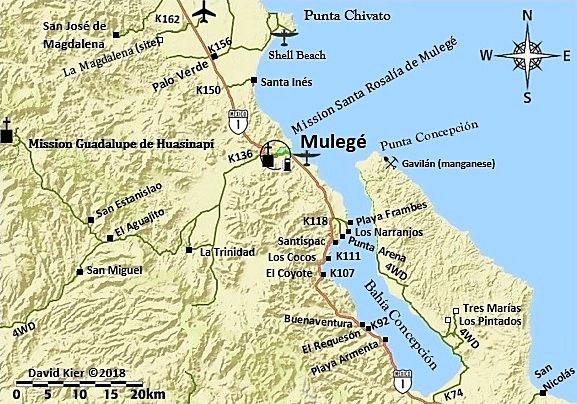
Here is my map for visual reference.

[Edited on 9-23-2021 by David K]
|
|
|
SFandH
Elite Nomad
     
Posts: 7431
Registered: 8-5-2011
Member Is Offline
|
|
Has anybody here ever driven across the peninsula that forms Bahia Concepcion to the Sea of Cortez side? Way, way north of San Nicholas. This looks
interesting.
26°43'05.4"N 111°36'22.6"W
[Edited on 9-23-2021 by SFandH]
|
|
|
David K
Honored Nomad
        
Posts: 65361
Registered: 8-30-2002
Location: San Diego County
Member Is Offline
Mood: Have Baja Fever
|
|
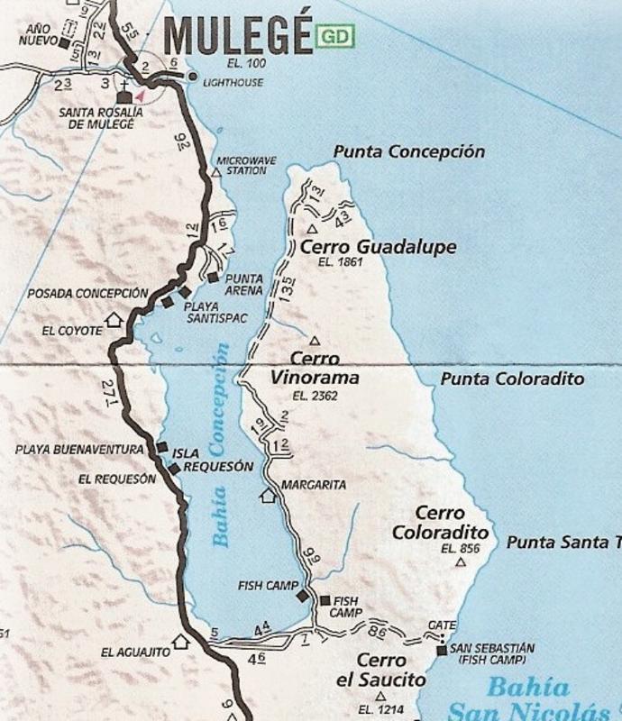
Ged mentioned it (San Sebastian):
It is on the AAA map of 2010:

On the 2021 Baja Atlas:

[Edited on 9-23-2021 by David K]
|
|
|
pacificobob
Super Nomad
   
Posts: 2340
Registered: 4-23-2006
Member Is Offline
|
|
Excellent video.
|
|
|
SFandH
Elite Nomad
     
Posts: 7431
Registered: 8-5-2011
Member Is Offline
|
|
Way north of San Sebastion. In the middle of the peninsula, south of Punta Coloradito where the river bed on your map is.
|
|
|
nbentley1
Nomad
 
Posts: 140
Registered: 9-16-2016
Member Is Offline
|
|
Great video, always wondered what was on that side of the bay
|
|
|
JZ
Select Nomad
      
Posts: 13450
Registered: 10-3-2003
Member Is Offline
|
|
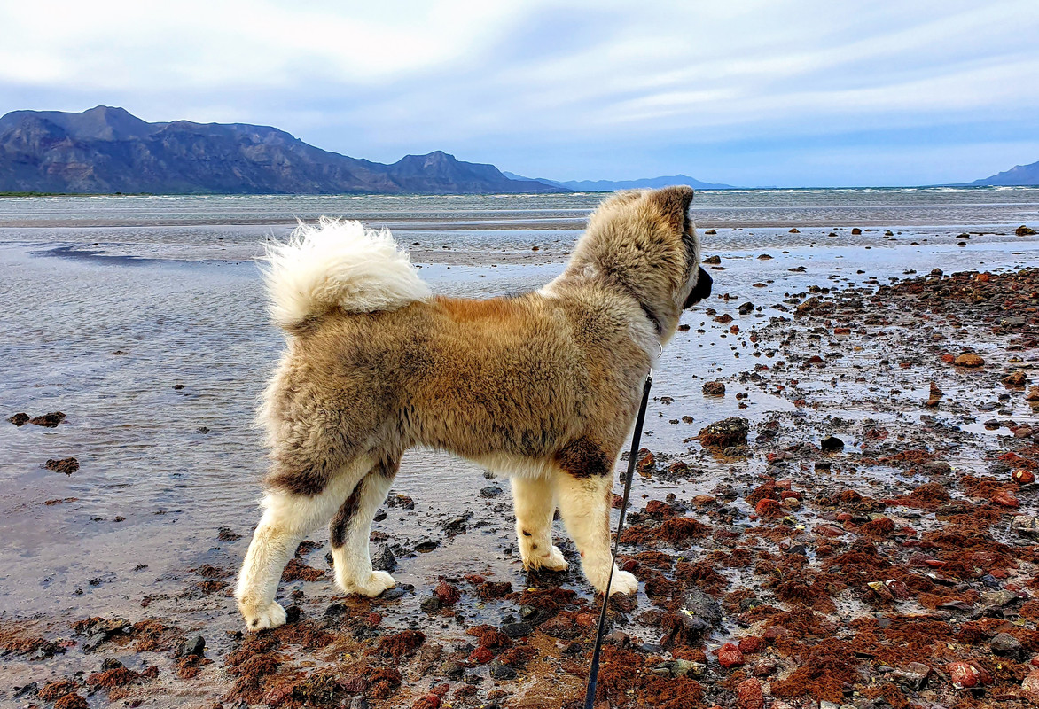
Pic from the far South end of Bahia Concepcion.

[Edited on 9-23-2021 by JZ]
|
|
|
David K
Honored Nomad
        
Posts: 65361
Registered: 8-30-2002
Location: San Diego County
Member Is Offline
Mood: Have Baja Fever
|
|
Quote: Originally posted by SFandH  |
Way north of San Sebastion. In the middle of the peninsula, south of Punta Coloradito where the river bed on your map is. |
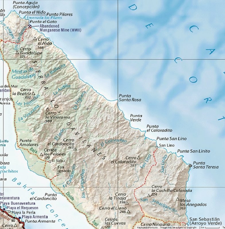
OK, got ya... Big mountain range limits cross-peninsula travel. Here is the rest of it north from San Sebastian. Just one more road to a fish camp
(San Lino) on the 2021 map plus the Manganese mine near the north end:

|
|
|
KurtG
Super Nomad
   
Posts: 1211
Registered: 1-27-2004
Location: California Central Coast
Member Is Offline
Mood: Press On Regardless!!
|
|
Quote: Originally posted by SFandH  |
Way north of San Sebastion. In the middle of the peninsula, south of Punta Coloradito where the river bed on your map is. |
25-30 years ago I spent quite of bit of time over there on "the far side" and I don't believe there is any type of road or even foot trail across
between the San Sebastian road and the mine road on the north end. If anyone has found one I would be most interested.
|
|
|
SFandH
Elite Nomad
     
Posts: 7431
Registered: 8-5-2011
Member Is Offline
|
|
San Lino. Gotta go there this winter. Maybe by boat, maybe by land. What are the coordinates where the cross peninsula road meets the bayside road?
|
|
|
KurtG
Super Nomad
   
Posts: 1211
Registered: 1-27-2004
Location: California Central Coast
Member Is Offline
Mood: Press On Regardless!!
|
|
David,
I followed a couple of old tracks by moto that went north off the San Sebastian road but they went nowhere. Again, this was nearly 30 years ago.
|
|
|
| Pages:
1
2 |

