| Pages:
1
2
3 |
Doug Landolfi
Junior Nomad

Posts: 66
Registered: 11-27-2018
Member Is Offline
|
|
Driving from El Cardonal to Bahia de los Muertos
Has anyone made the drive north from the El Cardonal area staying as close to the coast as possible - a "road" on some maps labeled "Los Barriles -
Santa Teresa"?
|
|
|
AKgringo
Elite Nomad
Posts: 5862
Registered: 9-20-2014
Location: Anchorage, AK (no mas!)
Member Is Online
Mood: Retireded
|
|
That is one of my favorite drives in Baja Sur. It can be challenging after any storm system, and grading seems to be random if at all, but there are
some incredible views along that route.
Four-wheel drive is best, but an experienced driver in a 2wd with good clearance should be fine.
If you are not living on the edge, you are taking up too much space!
"Could do better if he tried!" Report card comments from most of my grade school teachers. Sadly, still true!
|
|
|
Doug Landolfi
Junior Nomad
Posts: 66
Registered: 11-27-2018
Member Is Offline
|
|
Thank you AKgringo!
I have camped at Punta Arena, and have fished in Bahia de los Muertos. From a panga in the bay, I have wondered about the
few residences (?) one can see from the water, along that shore line - and wondered "how the heck do you get there?!?"
Have you found any beaches at which to camp along that stretch of coastline?
|
|
|
AKgringo
Elite Nomad
Posts: 5862
Registered: 9-20-2014
Location: Anchorage, AK (no mas!)
Member Is Online
Mood: Retireded
|
|
I have camped on the beaches north of El Cardonal, but once you start climbing away from the flat stretch of road, there are only a few possible
trails down to tide line.
The only traffic I passed on that road two years ago were some SXS UTVs, but I know that ranchers use the road. I saw a few places that might be good
campsites crossing over the pass, but have not used one of them yet.
[Edited on 7-4-2022 by AKgringo]
If you are not living on the edge, you are taking up too much space!
"Could do better if he tried!" Report card comments from most of my grade school teachers. Sadly, still true!
|
|
|
AKgringo
Elite Nomad
Posts: 5862
Registered: 9-20-2014
Location: Anchorage, AK (no mas!)
Member Is Online
Mood: Retireded
|
|
I should add that for quite a bit of that route, you are literally on the side of a cliff! 
If you are not living on the edge, you are taking up too much space!
"Could do better if he tried!" Report card comments from most of my grade school teachers. Sadly, still true!
|
|
|
willardguy
Elite Nomad
Posts: 6451
Registered: 9-19-2009
Member Is Offline
|
|
in the late 80's I did it in a rented Tsuru......we made but I wouldn't recommend it, pretty much crushed the bottom of that nissan
|
|
|
Doug Landolfi
Junior Nomad
Posts: 66
Registered: 11-27-2018
Member Is Offline
|
|
Thank you both. Man, that coastline along Bahia de los Muertos - if accessible - would be heaven on earth. To have a camper on a beach, and a boat
to access the bay, would be perfecto!
|
|
|
pacificobob
Super Nomad
Posts: 2257
Registered: 4-23-2006
Member Is Offline
|
|
I've made the drive a number of times over the years. Some trips were do-able with 2 wheel drive...other times challenging on a dirt bike. Like many
baja roads, ones local knowledge is only useful for the period since the last big rain.
|
|
|
AKgringo
Elite Nomad
Posts: 5862
Registered: 9-20-2014
Location: Anchorage, AK (no mas!)
Member Is Online
Mood: Retireded
|
|
The road leaves the coast probably five miles or more before it would reach Los Muertos. I don't know if there is a trail that continues to head that
way, but the route I followed crosses over a summit and intersects the main road a few miles east of Los Planes.
[Edited on 7-4-2022 by AKgringo]
If you are not living on the edge, you are taking up too much space!
"Could do better if he tried!" Report card comments from most of my grade school teachers. Sadly, still true!
|
|
|
Doug Landolfi
Junior Nomad
Posts: 66
Registered: 11-27-2018
Member Is Offline
|
|
Yup - I see on a map exactly what you are describing. The "road" turns from north to west, and heads towards 286.
I have in my head that I am going to buy a boat in La Paz during my next trip, and spend some time exploring that coast from the water. Find places
to land a dinghy, and do some hiking from the shoreline.
|
|
|
KRB
Junior Nomad
Posts: 25
Registered: 11-29-2019
Member Is Offline
|
|
Last time I drove it about a year and a half ago I was in a UTV and came across a couple is a full size 2 wheel drive pickup headed to La Paz. Google
maps had told them this was the best route for Los Barriles to La Paz. Thank you Google
This road makes the old rood from Los Barriles to Cardonal look like the interstate
|
|
|
elgatoloco
Ultra Nomad
Posts: 4324
Registered: 11-19-2002
Location: Yes
Member Is Offline
|
|
In 1999 we took the road north in a F-350 4WD Crew Cab Long Bed. We had been camping for a couple of weeks all along the east cape on different
beaches and ended up at El Cardonal. Instead of going south I thought we should check out the road north. The road was very narrow in spots and at
times the wife was looking straight down into the sea. More the once she told me to move left when there was no room to do that and a few times I
pulled me side mirror in. We stopped periodically to get out and marvel at the views. I have some photos looking down at big schools of large fish in
the very clear waters. At one point we saw humpbacks offshore breaching and slapping fins on the water. It was a bit of pucker factor ride not knowing
what was ahead but I recall thinking if a another vehicle is heading south it will be smaller and have to back up. Their were places to turn around or
pass in the areas where the road went down into arroyos. The last arroyo heading away from the sea and toward the asphalt had a very short stretch of
big boulders that required some rock crawling and the thought of having to maybe turn around. We made it thru with no damage to the undercarriage
which was good because it was a borrowed rig.
It was one of the coolest roads we have taken and I have always wanted to do it again and take the time to explore some of the beaches but maybe in
something a little smaller.
MAGA
Making Attorneys Get Attorneys
|
|
|
advrider
Super Nomad
Posts: 1847
Registered: 10-2-2015
Member Is Offline
|
|
Where is David with a map when you need one? Headed to my latest Baja Atlas now.
|
|
|
David K
Honored Nomad
Posts: 64548
Registered: 8-30-2002
Location: San Diego County
Member Is Offline
Mood: Have Baja Fever
|
|
My Maps:
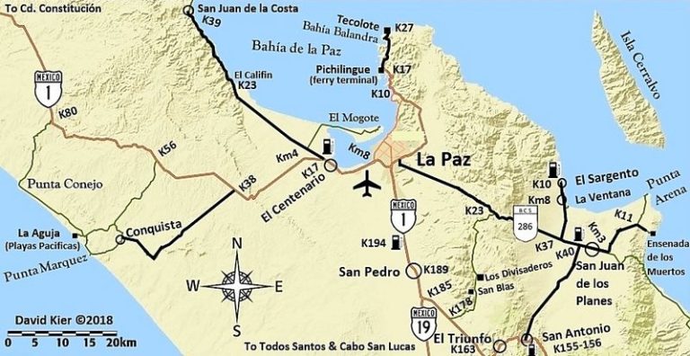
We drove it in 2012 with BajaTripper in his 4Runner on Day 6 of the trip, photos on the second page: https://vivabaja.com/p712/
We stayed close to the coast via Punta Pescadero and did not take the paved road that goes into the hills.
The only rough part was leaving the coast and crossing the ridge to meet the paved road between Los Planes and Ensenada de los Muertos.
|
|
|
AKgringo
Elite Nomad
Posts: 5862
Registered: 9-20-2014
Location: Anchorage, AK (no mas!)
Member Is Online
Mood: Retireded
|
|
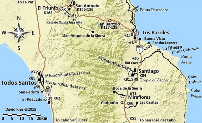
For what it is worth, the road that runs between hwy 286 and hwy 1 at San Antonio is a good, paved road. It would make a nice loop route if your plan
is not to continue on northward.
[Edited on 7-5-2022 by AKgringo]
If you are not living on the edge, you are taking up too much space!
"Could do better if he tried!" Report card comments from most of my grade school teachers. Sadly, still true!
|
|
|
AKgringo
Elite Nomad
Posts: 5862
Registered: 9-20-2014
Location: Anchorage, AK (no mas!)
Member Is Online
Mood: Retireded
|
|
Thanks for the maps David! Talking about possible loop routes, the dirt road that runs between 286 and 1 (west of the paved road) is a well graded
dirt road that I found very enjoyable.
If you are not living on the edge, you are taking up too much space!
"Could do better if he tried!" Report card comments from most of my grade school teachers. Sadly, still true!
|
|
|
David K
Honored Nomad
Posts: 64548
Registered: 8-30-2002
Location: San Diego County
Member Is Offline
Mood: Have Baja Fever
|
|
Quote: Originally posted by AKgringo  | | Thanks for the maps David! Talking about possible loop routes, the dirt road that runs between 286 and 1 (west of the paved road) is a well graded
dirt road that I found very enjoyable. |
I did not drive it, no... but it is on the map as it is well-signed. Did you visit the church in San Blas? The trail up to the La Paz mission visita
of Angel de la Guarda goes up from there. Photos of it from Jack Swords in his section on VivaBaja.com
|
|
|
bajafreaks
Nomad
Posts: 401
Registered: 3-27-2007
Location: Gardnerville, NV./ Los Barriles BCS
Member Is Offline
Mood: No Bad Days !!!
|
|
| Quote: Originally posted by AKgringo | I have camped on the beaches north of El Cardonal, but once you start climbing away from the flat stretch of road, there are only a few possible
trails down to tide line.
The only traffic I passed on that road two years ago were some SXS UTVs, but I know that ranchers use the road. I saw a few places that might be good
campsites crossing over the pass, but have not used one of them yet.
[Edited on 7-4-2022 by AKgringo] |
This is exactly right, did the drive in May this year. 4 people in a 4 seat SXS I didn't see any access to the beach once we started climbing out of
El cardonal a lot of great views but not down at beach level all cliff side. The road is really rocky best with 4x4.
|
|
|
4x4abc
Ultra Nomad
Posts: 4202
Registered: 4-24-2009
Location: La Paz, BCS
Member Is Offline
Mood: happy - always
|
|
| Quote: Originally posted by bajafreaks |
This is exactly right, did the drive in May this year. 4 people in a 4 seat SXS I didn't see any access to the beach once we started climbing out of
El cardonal a lot of great views but not down at beach level all cliff side. The road is really rocky best with 4x4. |
one beach access about midway
23.926066°, -109.836383°
good camping - beach is super rocky
another beach access north from there is blocked off as private property
Harald Pietschmann
|
|
|
Marty Mateo
Nomad
Posts: 103
Registered: 12-7-2019
Location: Vanisle Sur
Member Is Offline
|
|
Great coast road all the way from Los Barriles. The only potentially rough area is where the road leaves the coast and heads towards Los Planes. Drove
the road down through El Triunfo to Los Barriles on Saturday, very lush and green till just south of San Bartolo, always enjoy that drive through the
mountains. A few arroyo areas north of El Cardinal that should make beach access possible for camping.
|
|
|
| Pages:
1
2
3 |


