| Pages:
1
2 |
DizzyNick
Newbie
Posts: 24
Registered: 2-21-2023
Member Is Offline
|
|
Rate My Route
Hey all!
After weeks of research and the kind help of this forum and others I have compiled a route for my upcoming 2 week trip to Baja! There will be a
handful of us all travelling on Husky 701 dual sports and this is our first time down. I would love the opinions of you guys on this route I have put
together.
We are planning on going south (blue lines) down the west coast to La Paz then back up the east coast (green lines). The red lines are optional more
challenging routes. Ignore the pins as they are just start and finish of individual tracks that I laid out or downloaded
https://www.google.com/maps/d/edit?mid=1-Vd8MoIAInut206y_XIp...
[Edited on 2-26-2023 by DizzyNick]
|
|
|
David K
Honored Nomad
        
Posts: 65434
Registered: 8-30-2002
Location: San Diego County
Member Is Offline
Mood: Have Baja Fever
|
|
Wow, what an ambitious route!
Some of the mountain roads may be difficult or gone after the last hurricane, that was so damaging.
I hope you will share your trip photos and story with us when you get back.
Thank you.
|
|
|
AKgringo
Elite Nomad
     
Posts: 6306
Registered: 9-20-2014
Location: Anchorage, AK (no mas!)
Member Is Offline
Mood: Retireded
|
|
The section of your route that heads south from San Ignacio, then eastward toward Mulege is one that I have wanted to check out. I wound up not doing
it because multiple contacts told me that there is a section that was not passable before the last typhoon (Kay).
I am looking forward to your report after you give it a go. Good luck, and I won't bother telling you to be careful. What fun would that be?
If you are not living on the edge, you are taking up too much space!
"Could do better if he tried!" Report card comments from most of my grade school teachers. Sadly, still true!
|
|
|
TMW
Select Nomad
      
Posts: 10659
Registered: 9-1-2003
Location: Bakersfield, CA
Member Is Offline
|
|
Just at first glance The trail from San Ignacio to San Juanico is not possible. There is no road or trail where the top green pin is. It was wiped out
by a hurricane in 2014. There has been some bikers get thru but they had to carry their bikes over part of it. That is the section SE of the label
Rancho Nuevo.
|
|
|
TMW
Select Nomad
      
Posts: 10659
Registered: 9-1-2003
Location: Bakersfield, CA
Member Is Offline
|
|
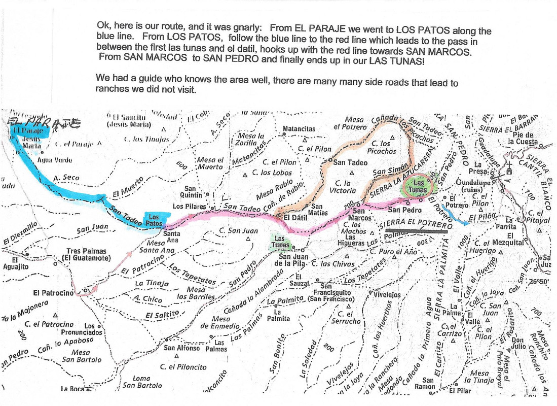
NOMAD Baja Blanca and her husband were taken to Rancho Las Tunas in 2014 after the hurricane and this is the route they took. They had a guide or the
owner of the ranch took them there.
|
|
|
TMW
Select Nomad
      
Posts: 10659
Registered: 9-1-2003
Location: Bakersfield, CA
Member Is Offline
|
|
The road was wiped out from Las Tunas to Guadalupe.
|
|
|
DizzyNick
Newbie
Posts: 24
Registered: 2-21-2023
Member Is Offline
|
|
Thank you for the replies everyone! Yes it is an aggressive route and I doubt we will be able to do all the tracks I have laid out, but it's nice to
know which ones are doable and then resort to taking main routes when we fall behind on time.
I was skeptical about the routes up the canyons south of San Ignacio as I heard they were damaged, but remained hopeful that they had been repaired.
I've altered the map to reflect a change in the route, do you guys know if this will work?
I'll definitely be posting my trip here, although it won't be for a while as it's not until April
|
|
|
AKgringo
Elite Nomad
     
Posts: 6306
Registered: 9-20-2014
Location: Anchorage, AK (no mas!)
Member Is Offline
Mood: Retireded
|
|
The new route you posted south from San Ignacio will probably be no problem. There are many ranch roads through that area, so I am not sure if I took
the exact combination of turns that you plotted out, but it was no great challenge in my Isuzu Trooper two years ago.
If you are not living on the edge, you are taking up too much space!
"Could do better if he tried!" Report card comments from most of my grade school teachers. Sadly, still true!
|
|
|
advrider
Super Nomad
   
Posts: 1920
Registered: 10-2-2015
Member Is Offline
|
|
There is another cool track to Mulege from the Pacific called Icehouse Road. Fun ride. It is just past the small town where you cross the river before
Scorpion bay. Send me your number in a PM and I'll text you the track if you want it.
|
|
|
mtgoat666
Platinum Nomad
       
Posts: 20552
Registered: 9-16-2006
Location: San Diego
Member Is Offline
Mood: Hot n spicy
|
|
Quote: Originally posted by DizzyNick  | Hey all!
After weeks of research and the kind help of this forum and others I have compiled a route for my upcoming 2 week trip to Baja! There will be a
handful of us all travelling on Husky 701 dual sports and this is our first time down. I would love the opinions of you guys on this route I have put
together.
We are planning on going south (blue lines) down the west coast to La Paz then back up the east coast (green lines). The red lines are optional more
challenging routes. Ignore the pins as they are just start and finish of individual tracks that I laid out or downloaded
https://www.google.com/maps/d/edit?mid=1-Vd8MoIAInut206y_XIp...
[Edited on 2-26-2023 by DizzyNick] |
Looks like a plan. If it does not work out, follow plan b!
[Edited on 2-26-2023 by mtgoat666]
Woke!
Hands off!
“Por el bien de todos, primero los pobres.”
“...ask not what your country can do for you – ask what you can do for your country.” “My fellow citizens of the world: ask not what America
will do for you, but what together we can do for the freedom of man.”
Pronoun: the royal we
|
|
|
MulegeAL
Nomad
 
Posts: 299
Registered: 8-25-2009
Location: PDX/Mulege
Member Is Offline
|
|
There is no road anymore from the mission Guadelupe to San Jose de Magdalena, it is totally wiped out in the box canyon, and the approaches from
either end are very rough rock, even by Baja standards.
The road north from rancho Guajademi jct to the pass at Chuparossa canyon has turned back into a mountain again due to severe hurricane damage.
Expect very rough off-camber loose climb to the top and down the other side. Cannot recommend this route except to people I don't like (you not one
of them).
I rode to the top of Chuparossa canyon about 2 weeks ago from Mulege side. Very rough tough loose rock the whole way up & down the canyon. I
ride a XR600 full knobs here, many years.
Recommend the Ice house route from La Ballena east to Mulege, start from San Juanico. Turn east at La Ballena. Or, for more punishment, turn in at
Cadaje and find the short cut over the mesa to same route.
Try not to get too stuck on through routes, most good rides around here are out and back trips, like the Bay of Conception penninsula for example. Or
day loop to San Sebastian/San Nicholas.
Timing: when do you expect to be in the area here? I winter here, have tools, air, etc but no Husky parts, but will likely be gone by April.
Good luck with the Huskies, kinda heavy for the tough stuff here, hope you don't have big loads. Expect/plan for pinch flats!
You are smart for asking here, don't believe everything you find on maps or sites!
Also, one of you should bring a copy of the Baja California Road & Recreation Atlas. Best single map document available. Runs without internet!
https://www.bajabound.com/baja-atlas
[Edited on 2-26-2023 by MulegeAL]
[Edited on 2-26-2023 by MulegeAL]
[Edited on 2-26-2023 by MulegeAL]
[Edited on 2-26-2023 by MulegeAL]
|
|
|
TMW
Select Nomad
      
Posts: 10659
Registered: 9-1-2003
Location: Bakersfield, CA
Member Is Offline
|
|
Will you guys have any type of communication devices in case of an emergency. Spot, sat phones, InReach etc. This is a pretty bold trip with much of
it in the middle of no where, things do happen.
Also if you do then you should have one person that can coordinate your needs. That person should really be familiar with Baja. Too many people
involved can create a log jam.
[Edited on 2-26-2023 by TMW]
|
|
|
JZ
Select Nomad
      
Posts: 13921
Registered: 10-3-2003
Member Is Online
|
|
I've ridden most of those. I'd give it an A+.
Edit: ignore this. I just saw you have it on our route.
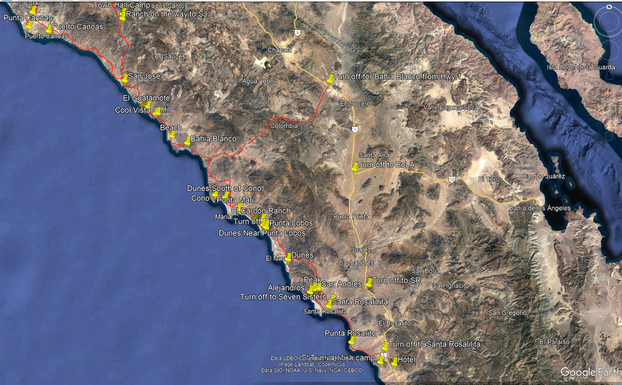
Biggest thing I would change for sure would be to go up the coast through the Seven Sisters instead of going inland. The beaches and bays are super
sweet. You'd really be missing out if you bypassed them. It's a pretty easy ride. At the Northern end it gets a little rough in a truck, but easy
on a bike.
I have tracks if you need them.
[Edited on 2-26-2023 by JZ]
|
|
|
JZ
Select Nomad
      
Posts: 13921
Registered: 10-3-2003
Member Is Online
|
|
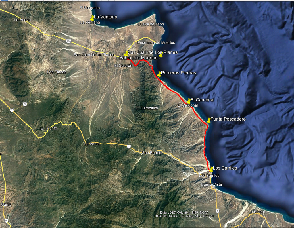
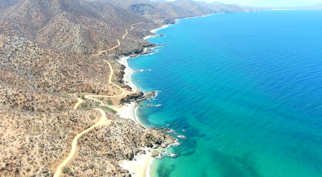
Here is another ride you might consider just below La Paz. Top 3 coastal ride in Baja. San Juan de Los Planes to Los Barriles.
|
|
|
JZ
Select Nomad
      
Posts: 13921
Registered: 10-3-2003
Member Is Online
|
|
The view.
|
|
|
JZ
Select Nomad
      
Posts: 13921
Registered: 10-3-2003
Member Is Online
|
|
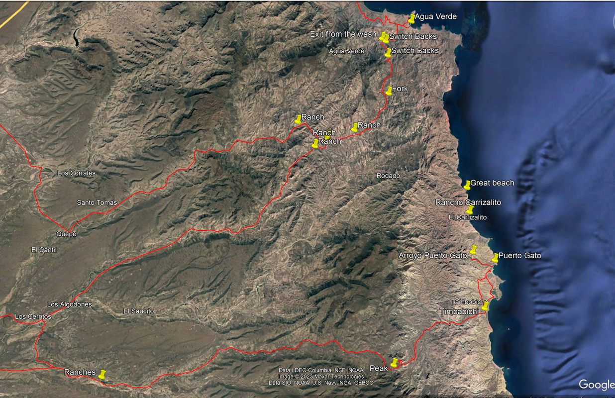
Another super cool ride is below Agua Verde to Timbabichi / Puerto Gato.
|
|
|
JZ
Select Nomad
      
Posts: 13921
Registered: 10-3-2003
Member Is Online
|
|
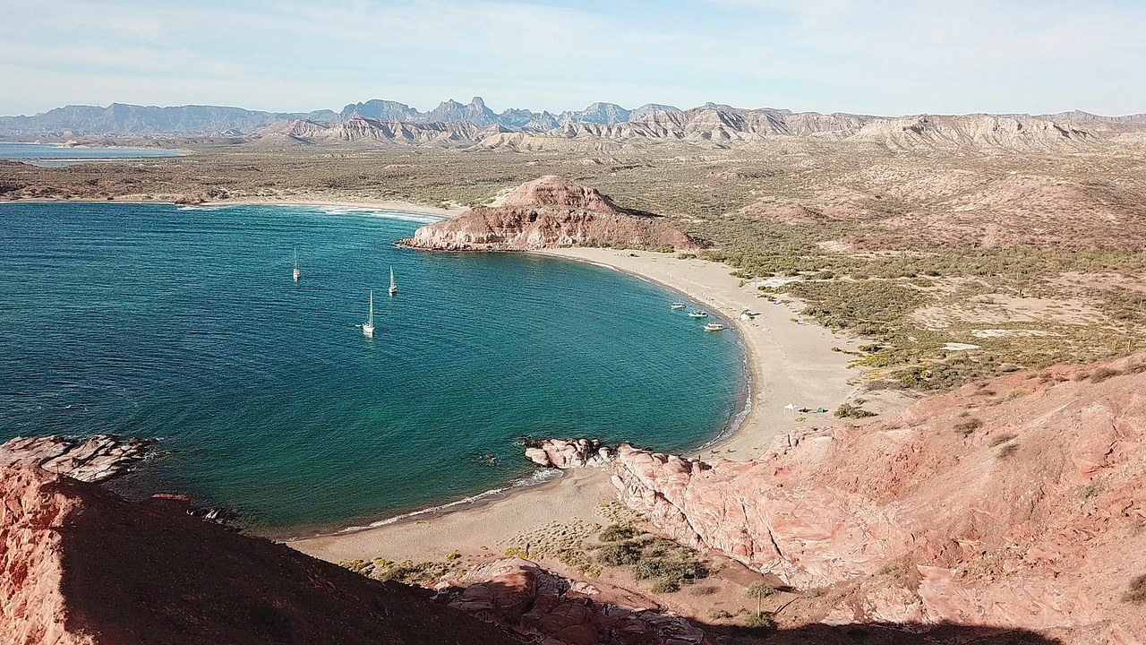
Puerto Gato.
[Edited on 2-26-2023 by JZ]
|
|
|
DizzyNick
Newbie
Posts: 24
Registered: 2-21-2023
Member Is Offline
|
|
Quote: Originally posted by MulegeAL  | There is no road anymore from the mission Guadelupe to San Jose de Magdalena, it is totally wiped out in the box canyon, and the approaches from
either end are very rough rock, even by Baja standards.
The road north from rancho Guajademi jct to the pass at Chuparossa canyon has turned back into a mountain again due to severe hurricane damage.
Expect very rough off-camber loose climb to the top and down the other side. Cannot recommend this route except to people I don't like (you not one
of them).
I rode to the top of Chuparossa canyon about 2 weeks ago from Mulege side. Very rough tough loose rock the whole way up & down the canyon. I
ride a XR600 full knobs here, many years.
Recommend the Ice house route from La Ballena east to Mulege, start from San Juanico. Turn east at La Ballena. Or, for more punishment, turn in at
Cadaje and find the short cut over the mesa to same route.
Try not to get too stuck on through routes, most good rides around here are out and back trips, like the Bay of Conception penninsula for example. Or
day loop to San Sebastian/San Nicholas.
Timing: when do you expect to be in the area here? I winter here, have tools, air, etc but no Husky parts, but will likely be gone by April.
Good luck with the Huskies, kinda heavy for the tough stuff here, hope you don't have big loads. Expect/plan for pinch flats!
You are smart for asking here, don't believe everything you find on maps or sites!
Also, one of you should bring a copy of the Baja California Road & Recreation Atlas. Best single map document available. Runs without internet!
https://www.bajabound.com/baja-atlas
[Edited on 2-26-2023 by MulegeAL]
[Edited on 2-26-2023 by MulegeAL]
[Edited on 2-26-2023 by MulegeAL]
[Edited on 2-26-2023 by MulegeAL] |
Thank you I have removed the loop around Guadalupe. It's too bad about the hurricane damage as I was really looking forward to exploring this area. I
do not have a full gpx of the Ice House road, only approximate start and end. Can anyone help me out with this? Or even a screen shot of it and I can
manually plot a route.
We will be in Baja from approx april 16 to april 30. If you are still around then we would love to meet up for a ride!
|
|
|
JZ
Select Nomad
      
Posts: 13921
Registered: 10-3-2003
Member Is Online
|
|
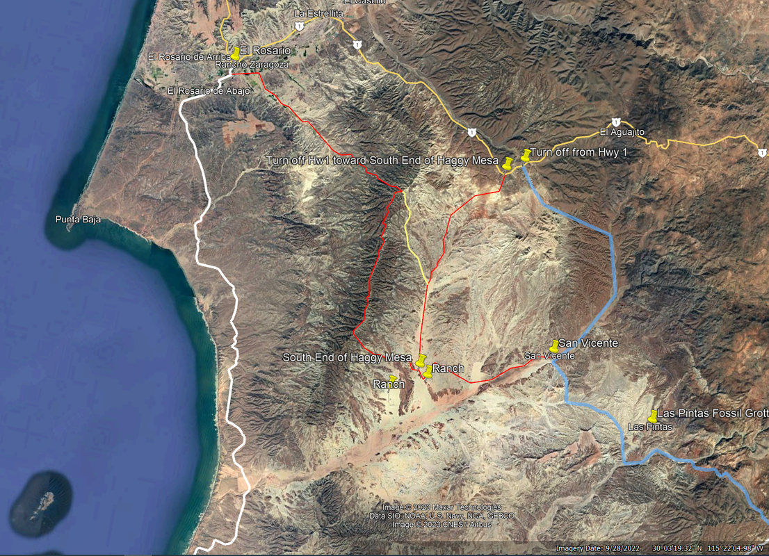
Here is an alternative route that is East of yours going into El Rosario. It rides Haggy's Mesa. Never do it, but it looks like a lot of fun.
|
|
|
DizzyNick
Newbie
Posts: 24
Registered: 2-21-2023
Member Is Offline
|
|
Quote: Originally posted by TMW  | Will you guys have any type of communication devices in case of an emergency. Spot, sat phones, InReach etc. This is a pretty bold trip with much of
it in the middle of no where, things do happen.
Also if you do then you should have one person that can coordinate your needs. That person should really be familiar with Baja. Too many people
involved can create a log jam.
[Edited on 2-26-2023 by TMW] |
A few of us will have In Reach and Zoleo devices, and everyone will have the gps track on their phone/gps. Unfortunately we dont know anyone in baja,
but we go out on several trips a year to remote areas and have grown accustomed to making "trail fixes"
That being said we have agreed to "take it easy" this trip, which is a relative term I know!
|
|
|
| Pages:
1
2 |

