| Pages:
1
2
3
..
10 |
Lance S.
Nomad
 
Posts: 231
Registered: 2-16-2021
Member Is Offline
|
|
San Ignacio - La Sierrita Route
Route begins on page 436
https://sachsen.digital/werkansicht/18685/440?tx_dlf_navigat...
A quick look at the route described in Itinerarios y Derroteros. The section from San Ignacio to San Andreas is well described. At San Andreas
the route split in two and rejoined at a place called La Sierrita. . The costal route was difficult and seldom used. Below is a rundown of what may
have been the main route from San Andreas to La Sierrita.
San Andres, that is what Goldbaum seems to label this location., mislabeled?
28°47'04"N 114°10'03"W
Water 29°00'04"N 114°15'31"W
Codornices 29°11'18"N 114°18'35"W
Water 29°13'35"N 114°28'06"W
Salado (Aguaje Salado?) There is a salt flat nearby that probably explains the name. 29°18'01"N 114°34'47"W
San Jose de Las Palomas. A rancheria name that appears frequently in the registers for San Fernando
Appears as Codornices on modern maps. 29°24'13"N 114°37'09"W
Need to fill in this section between Palomas and San Julio, its on Goldbaum, will come back to it. The water source for Cerro Blanco?
Rancho San Julio right in here somewhere 29°40'01"N 114°55'02"W
Water 29°45'05"N 114°58'22"W
Catarina, S. Catarina on 1922 map and Catavina on Goldbaum. 9°50'50"N 115°01'49"W
La Sierrita 29°52'00"N 115°03'36"W
The whole thing is shown on Goldbaum.
[Edited on 4-16-2023 by Lance S.]
[Edited on 1-4-2024 by Lance S.]
[Edited on 4-13-2024 by Lance S.]
|
|
|
Lance S.
Nomad
 
Posts: 231
Registered: 2-16-2021
Member Is Offline
|
|
Really should be called the San Ignacio - San Fernando route since that's what essentially is. Was it an arm of the camino real? One of Crosby's
criteria is documented use before 1822. The earliest I can find is 1849 and that follows the costal arm.
The Dominican military button found on the route is intriguing though. It's harder to believe the route wasn't used in the mission period.
[Edited on 1-4-2024 by Lance S.]
[Edited on 1-4-2024 by Lance S.]
|
|
|
David K
Honored Nomad
        
Posts: 65440
Registered: 8-30-2002
Location: San Diego County
Member Is Offline
Mood: Have Baja Fever
|
|
Consag explored that region on his third expedition (1751?) but he found no location that made a mission possible.
No ECR documented route. But, who knows for sure beyond those alive at the time?
|
|
|
4x4abc
Ultra Nomad
    
Posts: 4454
Registered: 4-24-2009
Location: La Paz, BCS
Member Is Offline
Mood: happy - always
|
|
Quote: Originally posted by Lance S.  | A quick rundown of the route described in Itinerarios y Derroteros. The section from San Ignacio to San Andreas is well described. At San Andreas
the route split in two and rejoined at a place called La Sierrita. . The costal route was difficult and seldom used. Below is a rundown of the main
route from San Andreas to La Sierrita before it began shifting over to accommodate wheeled vehicle travel.
San Andres, that is what Goldbaum seems to label this location., mislabeled?
28°47'04"N 114°10'03"W
Water 29°00'04"N 114°15'31"W
Codornices 29°11'18"N 114°18'35"W
Water 29°13'35"N 114°28'06"W
Salado (Aguaje Salado?) There is a salt flat nearby that probably explains the name. 29°18'01"N 114°34'47"W
San Jose de Las Palomas. A rancheria name that appears frequently in the registers for San Fernando
Appears as Codornices on modern maps. 29°24'13"N 114°37'09"W
Need to fill in this section between Palomas and San Julio, its on Goldbaum, will come back to it. The water source for Cerro Blanco?
Rancho San Julio right in here somewhere 29°40'01"N 114°55'02"W
Water 29°45'05"N 114°58'22"W
Catarina, S. Catarina on 1922 map and Catavina on Goldbaum. 9°50'50"N 115°01'49"W
La Sierrita 29°52'00"N 115°03'36"W
The whole thing is shown on Goldbaum. Most of what is on that map can now be followed by road. This route is exceptional in that hardly any of it
can. Maybe I can get some help filling it in a little bit.
[Edited on 4-16-2023 by Lance S.] |
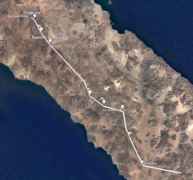
the route you are proposing

Harald Pietschmann
|
|
|
Lance S.
Nomad
 
Posts: 231
Registered: 2-16-2021
Member Is Offline
|
|
Las Palomas is definitely in the wrong place on your map. Let me check the coordinates I posted.
|
|
|
Lance S.
Nomad
 
Posts: 231
Registered: 2-16-2021
Member Is Offline
|
|
Quote: Originally posted by David K  | Consag explored that region on his third expedition (1751?) but he found no location that made a mission possible.
No ECR documented route. But, who knows for sure beyond those alive at the time? |
At San Andres Consag formed two groups from his footman and had one group head east and the other north to Los Ojitos. The group that went east made
it to Codornices according to Linck.
Just like the San Ignacio-La Sierrita Route. San Andres was already an important trail junction when Consag arrived.
After 1768 the real focus became the missions of Alta California and people wanted to get between there and Loretto quickly. No reason to stop at
San Borja and Santa Maria closed. If I had to put money on it I'd bet the route began getting regular use during the Dominican Period.
[Edited on 4-16-2023 by Lance S.]
[Edited on 8-27-2023 by Lance S.]
|
|
|
Lance S.
Nomad
 
Posts: 231
Registered: 2-16-2021
Member Is Offline
|
|
Harald you may have placed Las Palomas at Codornices.
This is San Jose de Las Palomas, now also named Codornices on modern maps.
29°24'16"N 114°37'09"W
[Edited on 4-16-2023 by Lance S.]
|
|
|
4x4abc
Ultra Nomad
    
Posts: 4454
Registered: 4-24-2009
Location: La Paz, BCS
Member Is Offline
Mood: happy - always
|
|
Quote: Originally posted by Lance S.  | Harald you may have placed Las Palomas at Codornices.
This is San Jose de Las Palomas, now also named Codornices on modern maps.
29°24'16"N 114°37'09"W
[Edited on 4-16-2023 by Lance S.] |
the line follows the points given by you
I did not name the Codornices point in the image
Las Palomas de San Jose is at the point you provided
I double checked - it's all where you wanted it
how did you get the points?
because some don't match the location where they should be
Harald Pietschmann
|
|
|
Lance S.
Nomad
 
Posts: 231
Registered: 2-16-2021
Member Is Offline
|
|
Thank you Harald! That is a good representation of how the route runs on goldbaum. I may have had Palomas in the wrong place. Was using ge
coordinates.
Now I'm trying to fill in between Las Palomas and San Julio. Goldbaum makes it look like a straight run but there must be a stop in between.
|
|
|
Lance S.
Nomad
 
Posts: 231
Registered: 2-16-2021
Member Is Offline
|
|
Also it begins at mission San Ignacio, not San Ignacito. That was a typo on my part.
|
|
|
4x4abc
Ultra Nomad
    
Posts: 4454
Registered: 4-24-2009
Location: La Paz, BCS
Member Is Offline
Mood: happy - always
|
|
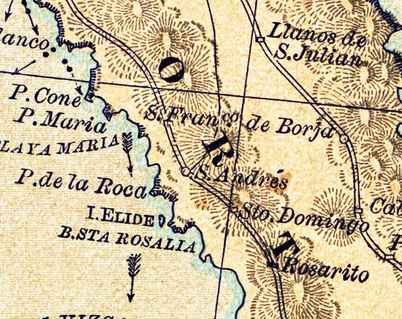
San Andres - earliest mention in a map 1884 by S. Voisin

Harald Pietschmann
|
|
|
4x4abc
Ultra Nomad
    
Posts: 4454
Registered: 4-24-2009
Location: La Paz, BCS
Member Is Offline
Mood: happy - always
|
|
San Jose (de las Palomas) here 29° 21.844'N, 114° 44.875'W
new maps show a location close to the ocean
Rancho san Julio (now La Bocana) 29° 40.638'N, 114° 53.556'W
Rancho Santa Catarina 29° 43.306'N, 115° 7.885'W
Harald Pietschmann
|
|
|
Lance S.
Nomad
 
Posts: 231
Registered: 2-16-2021
Member Is Offline
|
|
Ok I see the confusion now.
Your Las Palomas coordinates are for Codornices. My coordinates are correct for Las Palomas. There are two Las Palomas on Goldbaum, mine is the
northern one. That one is now called Codornices but it is not the same place as the Codornices we usually discuss here.
The old Rancho San Julio was a little up Arroyo San Julio on a side canyon.
Catarina and Santa Catarina are two different places. My coordinates are for an aquaje called Catarina.
|
|
|
Lance S.
Nomad
 
Posts: 231
Registered: 2-16-2021
Member Is Offline
|
|
My Las Palomas is between Codornices and San Julio on Goldbaum. If you follow the trail north from Codornices you first come to Salado then next is
Las Palomas.
[Edited on 4-16-2023 by Lance S.]
|
|
|
4x4abc
Ultra Nomad
    
Posts: 4454
Registered: 4-24-2009
Location: La Paz, BCS
Member Is Offline
Mood: happy - always
|
|
I am lost
Harald Pietschmann
|
|
|
Lance S.
Nomad
 
Posts: 231
Registered: 2-16-2021
Member Is Offline
|
|
Sorry it is confusing. Just find Codornices on Goldbaum (Rancho Codornices 29°11'17"N 114°18'32"W). The map shows a trail going north to Salado
then Las Palomas.
|
|
|
Lance S.
Nomad
 
Posts: 231
Registered: 2-16-2021
Member Is Offline
|
|
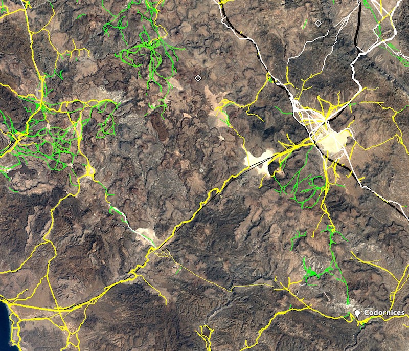
 uploading a photo uploading a photo
|
|
|
4x4abc
Ultra Nomad
    
Posts: 4454
Registered: 4-24-2009
Location: La Paz, BCS
Member Is Offline
Mood: happy - always
|
|
Quote: Originally posted by Lance S.  | Sorry it is confusing. Just find Codornices on Goldbaum (Rancho Codornices 29°11'17"N 114°18'32"W). The map shows a trail going north to Salado
then Las Palomas.
|
Salado is Laguna Chapala?

Harald Pietschmann
|
|
|
Lance S.
Nomad
 
Posts: 231
Registered: 2-16-2021
Member Is Offline
|
|
You know that small lake bed between Chapala and the coast? That is Salado. 29°16'05"N 114°34'34"W .Very salty water when it fills up, you can
probably see in past Google earth images. There is a waterhole nearby.
|
|
|
Lance S.
Nomad
 
Posts: 231
Registered: 2-16-2021
Member Is Offline
|
|
Water is at 29°18'01"N 114°34'46"W
|
|
|
| Pages:
1
2
3
..
10 |

