| Pages:
1
2
3 |
volcano3
Junior Nomad

Posts: 37
Registered: 12-9-2021
Member Is Offline
|
|
GPS app or device
What affordable app or devices are best for navigating obscure roads in Baja? We are in our 70’s, so not doing serious off-roading, but more poking
around on dirt roads in the Sierra de La Laguna, and the Sierra La Trinidad. No phone signal, older 4 -Runner, adventure enthusiasts
|
|
|
Jack Swords
Super Nomad
Posts: 1097
Registered: 8-30-2002
Location: Nipomo, CA/La Paz, BCS
Member Is Offline
|
|
Been all over Baja on dirt roads, Know Sierra de la Laguna well and nearby areas. We use Google Earth offline, by previously visiting intended areas
on Google Earth and caching (saving) it. Then you can access the saved areas offline. Scan in and out on areas so you have saved close and distant
views. GE will know where you are offline.
Save the images you want when offline. Google using Earth offline for more info.
|
|
|
chippy
Super Nomad
Posts: 1809
Registered: 2-2-2010
Member Is Offline
|
|
Get a benchmark Baja Ca. atlas (paper) and back it up with the app from avenza. E32 app is also good.
|
|
|
David K
Honored Nomad
Posts: 65581
Registered: 8-30-2002
Location: San Diego County
Member Is Offline
Mood: Have Baja Fever
|
|
Quote: Originally posted by chippy  | | Get a benchmark Baja Ca. atlas (paper) and back it up with the app from avenza. E32 app is also good. |
The 2023 (2nd Edition) Benchmark Baja Atlas ($26.95): https://www.benchmarkmaps.com/product/baja-california-road-r...
The 2023 Avenza/ Benchmark Baja Atlas App ($19.99): https://store.avenza.com/products/baja-california-atlas-land...
Discounted 2021 (1st Edition, second pressing) Benchmark Baja Atlas ($20.00): https://www.bajabound.com/baja-atlas
|
|
|
PaulW
Ultra Nomad
Posts: 3113
Registered: 5-21-2013
Member Is Offline
|
|
FYI
Got my 2nd edition and it says 2024 not 2023
Benchmark link also says: 2nd edition, 2024. ISBN: 9781734315059
Map Scales: Landscape Maps 1:300,000 Recreation Maps 1:1,000,000 La Paz & Los Cabos Recreation Maps 1:150,000
Of course it was released and printed in 2023.
|
|
|
PaulW
Ultra Nomad
Posts: 3113
Registered: 5-21-2013
Member Is Offline
|
|
Volcano
I second the recommendation for Google maps with preloaded with your choice of maps using its off- line feature. If your vehicle is compatible with
Carplay view the off- line maps on your nav screen by way of your iPhone. Your older Toyota probably won’t work with carplay.
For sure Google maps will display on your tablet/ iPhone/Android phone. Anywhere you go.
Just be aware that the back country roads on Google maps are limited compared to the Benchmark maps when displayed on your tablet/phone using Avenza
app. Also Benchmark paper map or book form – your choice.
|
|
|
wilderone
Ultra Nomad
Posts: 3914
Registered: 2-9-2004
Member Is Offline
|
|
Do you not have a paper map or have you found paper maps inadequate? Just asking because IMO the abovementioned Baja Atlas is all you'd need. Plenty
for the adventure enthusiast. Bring a shovel.
|
|
|
HeyMulegeScott
Senior Nomad
Posts: 719
Registered: 8-25-2009
Location: Orygone/Mulege
Member Is Offline
|
|
| Quote: Originally posted by wilderone | | Do you not have a paper map or have you found paper maps inadequate? Just asking because IMO the abovementioned Baja Atlas is all you'd need. Plenty
for the adventure enthusiast. Bring a shovel. |
I have the Baja Atlas and National Geographic paper maps they are not detailed enough for off-road and hiking.
I use Gaia GPS app on my phone and can get detailed maps for offline. It is really handy to record your tracks as your going especially handy when you
are out hiking and can use it to track back to your vehicle.
I also take my Garmin Inreach for similar purposes and offgrid communication. It's maps aren't that great however.
|
|
|
volcano3
Junior Nomad
Posts: 37
Registered: 12-9-2021
Member Is Offline
|
|
Yes, have always used the Baja Atlas. Getting the Benchmark as suggested. But wanting to try satellite link up, as dirt tracks, arroyos criss crossing
do not compute on paper maps. Specifically want todo the complete route from route 1 to Todos Santos on the Los Naranjas rd. this winter. The road
choices on the west side of the pass look complex. Paper maps have been no help as well in trying to locate the route to Rancho La Trinidad from the
southeast. (East Cape)
Thankyou for all the great suggestions.
[Edited on 11-19-2023 by volcano3]
|
|
|
David K
Honored Nomad
Posts: 65581
Registered: 8-30-2002
Location: San Diego County
Member Is Offline
Mood: Have Baja Fever
|
|
| Quote: Originally posted by volcano3 | Yes, have always used the Baja Atlas. Getting the Benchmark as suggested. But wanting to try satellite link up, as dirt tracks, arroyos criss crossing
do not compute on paper maps. Specifically want todo the complete route from route 1 to Todos Santos on the Los Naranjas rd. this winter. The road
choices on the west side of the pass look complex. Paper maps have been no help as well in trying to locate the route to Rancho La Trinidad from the
southeast. (East Cape)
Thankyou for all the great suggestions.
[Edited on 11-19-2023 by volcano3] |
The Avenza App for your phone or tablet gives you the brand new Benchmark map with a bulls-eye over your location, using satellites. NO CELL SERVICE
NEEDED. You can even create tracks of your trip. But, the best part is seeing where you are compared to what road you are seeking to be on.
See my 2022 Mission Santa María trip report using the Avenza App. I took a screen shot of the track going in and back out from the mission valley...
[Edited on 11-19-2023 by David K]
|
|
|
AKgringo
Elite Nomad
Posts: 6364
Registered: 9-20-2014
Location: Anchorage, AK (no mas!)
Member Is Offline
Mood: Retireded
|
|
Is The Los Naranjos road passable?
I tried that route last year and found a section on the west slope that was completely collapsed. It was an extremely steep cliff area that would be
hazardous to walk a mountain bike across.
It was at about 26 kilometers from hwy 1. I had tried to find the road from the Todos Santos side the day before, and I think I found the right
route, but it was not recognizable as a road through the drainage areas.
It has been a year, but unless a major commitment with construction equipment has been undertaken, that section of road is gone!
I had to turn around twice searching for the connection, but I still enjoyed the drive!
If you are not living on the edge, you are taking up too much space!
"Could do better if he tried!" Report card comments from most of my grade school teachers. Sadly, still true!
|
|
|
David K
Honored Nomad
Posts: 65581
Registered: 8-30-2002
Location: San Diego County
Member Is Offline
Mood: Have Baja Fever
|
|
It may be the worse designed road route on the peninsula!
|
|
|
volcano3
Junior Nomad
Posts: 37
Registered: 12-9-2021
Member Is Offline
|
|
Ak…. Last year I believe in Feb. we did from route 1 to the top of the pass. It looked like the folks that lived up there were using the road from
the pass on down the west side, but we turned around there…. It was a long day to return to our homes an hour south of La Ribera.
|
|
|
AKgringo
Elite Nomad
Posts: 6364
Registered: 9-20-2014
Location: Anchorage, AK (no mas!)
Member Is Offline
Mood: Retireded
|
|
I hope you are right. I posted a question about the road conditions about six months ago, but got no response from anyone who had successfully driven
it post "Kay".
Even last October the road from the east side had been opened, and was still in the process of being re-graded. the first half of the drive was 2wd
well past the summit.
The road from the west side had been worked on also, but only to the base of the mountain range.
If you are not living on the edge, you are taking up too much space!
"Could do better if he tried!" Report card comments from most of my grade school teachers. Sadly, still true!
|
|
|
volcano3
Junior Nomad
Posts: 37
Registered: 12-9-2021
Member Is Offline
|
|
We only used the 2wd.. guess we will find out this winter.
|
|
|
AKgringo
Elite Nomad
Posts: 6364
Registered: 9-20-2014
Location: Anchorage, AK (no mas!)
Member Is Offline
Mood: Retireded
|
|
I need to return to La Paz sometime soon to see a dentist I have been using for the last ten years. I may make a trip down to drive that road again,
even if it turns out to be a dead end. My dog and I always find a nice place to hang out and listen to cow bells all night!
If you get there first, let me know what you find. You may want to check out the dirt road that runs east from hwy 1 towards Cabo Pulmo. Nothing
special on that route, but I prefer back roads over pavement when I am not in a hurry.
If you are not living on the edge, you are taking up too much space!
"Could do better if he tried!" Report card comments from most of my grade school teachers. Sadly, still true!
|
|
|
4x4abc
Ultra Nomad
Posts: 4456
Registered: 4-24-2009
Location: La Paz, BCS
Member Is Offline
Mood: happy - always
|
|
in terms of apps on your phone or tablet - nothing neats GaiaGPS with a subscription of Baja government topo maps (INEGI)
I map Baja professionally and have 5 or 6 apps loaded on my phone
GaiaGPS with INEGI topos beats them all hands down.
The topos need to be preloaded when you have wifi - they work flawlessly when offline
none of the tools will tell you anything about current road conditions
on occasion you may have to turn around when the road gets too bad
the latest sat images show Los Naranjos Road in good condition
https://www.facebook.com/groups/651595359982880
Harald Pietschmann
|
|
|
chippy
Super Nomad
Posts: 1809
Registered: 2-2-2010
Member Is Offline
|
|
| Quote: Originally posted by 4x4abc | in terms of apps on your phone or tablet - nothing neats GaiaGPS with a subscription of Baja government topo maps (INEGI)
I map Baja professionally and have 5 or 6 apps loaded on my phone
GaiaGPS with INEGI topos beats them all hands down.
The topos need to be preloaded when you have wifi - they work flawlessly when offline
none of the tools will tell you anything about current road conditions
on occasion you may have to turn around when the road gets too bad
the latest sat images show Los Naranjos Road in good condition
https://www.facebook.com/groups/651595359982880 |
When using gaia do you use the inegi maps only or a combo?
Thanks for any reply.
|
|
|
pacificobob
Super Nomad
Posts: 2381
Registered: 4-23-2006
Member Is Offline
|
|
Love gaia. Always have paper maps .
|
|
|
4x4abc
Ultra Nomad
Posts: 4456
Registered: 4-24-2009
Location: La Paz, BCS
Member Is Offline
Mood: happy - always
|
|
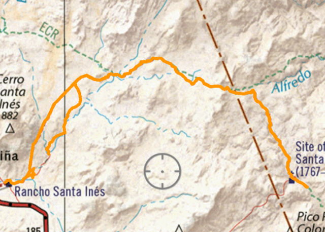
I only use only the INEGI maps
they have the best detail of all maps on the market
see the differences of available apps here:
https://www.facebook.com/photo?fbid=10161355156347281&se...
GaiaGPS with both Mapbox maps and GaiaGPS topo maps activated. Neither map provides any information. No road, no houses, no names of mountains or
Arroyos.

GaiaGPS with INEGI topos activated. Good detail, only limited by your phone's
or tablet's or dash display screen size

Avenza app with Benchmark Maps "Baja California Atlas" downloaded. In print this atlas is pretty helpful for a Baja overview - but it disappoints in
detail on your device. You can't even get to the same zoom level as the 2 screen shots above.

Harald Pietschmann
|
|
|
| Pages:
1
2
3 |


