BajaNomad

4x4/Off-Road Camp & Hike: Cañon Palomar and Baja Pole Line Rd. - November 23-26, 2013

Ken Cooke - 10-9-2013 at 08:37 PM

link: http://groups.yahoo.com/neo/groups/justruns/conversations/me...


[Edited on 11-16-2013 by Ken Cooke]

edm1 - 10-9-2013 at 09:48 PM

That Wrong Way Enmedio looks worse/difficult than our Mision Sta Maria Widowmaker run in 2010.

[Edited on 10-10-2013 by edm1]

Taco de Baja - 10-10-2013 at 08:12 AM

I will look forward to the trip report.
Doing that trip (by accident) once was enough for me. Beautiful country but near the limits of my little Tacoma. Some scary off-camber, boulder choked, HolyCr*pWhatTheFDidIGetInto moments. However, seeing the video, I'm really glad I did not have a full-size vehicle. :o

Ken Cooke - 10-10-2013 at 05:44 PM

Quote:
Originally posted by edm1
That Wrong Way Enmedio looks worse/difficult than our Mision Sta Maria Widowmaker run in 2010.

[Edited on 10-10-2013 by edm1]


Taking the wrong way down Cañon Enmedio past Neal Johns' Basketball Hill is much worse than the "Mission Impossible" trail. Especially, with the new Basketball Hill bypass you must take to go around a downed boulder sitting in the middle of the trail. TW's Toyota pickup drove up and around it without breaking a sweat. Your big rig might have some difficulties, though.


MICK - 10-10-2013 at 07:21 PM

nice looking ranger in the front
Mick

Photo credits

Ken Cooke - 10-10-2013 at 08:05 PM

Quote:
Originally posted by MICK
nice looking ranger in the front
Mick


Left to Right

Penny & MICK (Ford Ranger) Marco & daughter (Rover), Russ (Khaki TJ), CG & son Noe (Silver TJ), Ken & Leidys (Silver TJ), and Scott & Gaila (Rover)

Ken Cooke - 10-26-2013 at 08:15 AM

New Currie steering, Daystar bushings, Crown steering arm - INSTALLED! The Jeep is now road-worthy, and made the commute 2x this week! BAJA, WE'RE READY!!:bounce:

David K - 10-26-2013 at 09:48 AM

Wow....

Ken Cooke - 10-27-2013 at 09:31 PM

November 23rd through 26th, I will be hosting a run along the 1942 Pole Line Road. The history of this region is quite fascinating. This short article that I wrote in 2006 describes the topography and flora of this magical region about 100 miles south of the Calexico, CA area. Feel free to email me with questions you may have of this region.

In 1942, a communications road was constructed from coastal Ensenada , Mexico to the sleepy fishing village of San Felipe , Mexico . It was feared that in 1942, Japanese submarines would attack the United States by first gaining control of the upper Sea of Cortez and possibly all of Baja , California . President Roosevelt had already launched the construction of the Alaskan Highway , and had offered the Mexican government assistance in building a transpeninsular roadway linking Ensenada to the southern-most reaches of the Baja peninsula. At that time, the Mexican government did not see the use for a transpeninsular highway. Instead, a rock-lined route was constructed that would aid in the installation of a telephone line that would connect military personnel in Ensenada to San Felipe, and vice-versa.

This telephone route travels the width of Baja , California alongside what is now Highway 3. The telephone line breaks away from this highway as the forested Sierra Juarez escarpment drops in elevation to meet the desert environs down below.

The Pole Line trail begins at the intersection of a Smoke Tree-lined wash, and a rock-lined trail which climbs atop a heavily vegetated mesa. Covering approximately 150 miles from start to finish, the Pole Line trail contains several washouts, obstacles, and off-camber hillclimbs. Maintenance has been sparse at best over the past 71 years to this road. Stock-height SUVs were able to travel the entire length - 150 miles, although they spend more time picking their lines through rock-lined arroyos than soaking in the unusual geography.

Traveling along the start of the Pole Line trail, the scenery unfolds with striking scenery which features wildflowers, red soils, and rocky buttes stretching up into the skyline. Flowers jet prominently from the tops of: Mojave Yucca, Barrel Cactii, Buckhorn Cholla, Salvia, Desert Mallow, and the numerous Brittlebush that dotted the hillsides along this scenic trail.

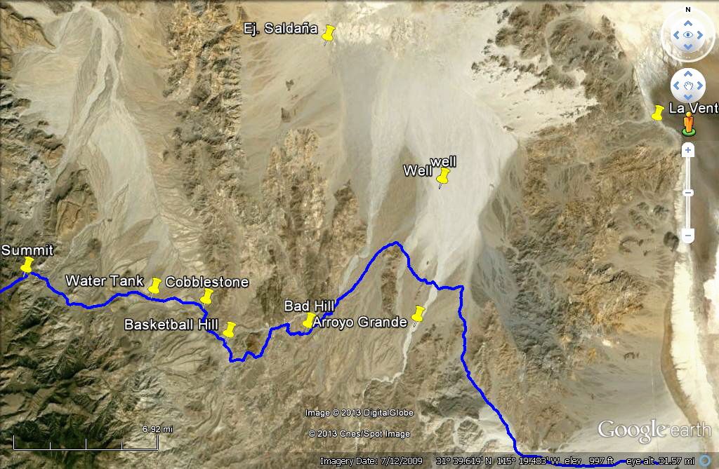
Approximately 94 miles south from where drivers pick up the dirt trail for this run along Highway 2 lies one of the sole remaining cobblestone sections of road to be found. This section of the Pole Line road travels along the east slope of the Canyon Enmedio. Although the Baja Almanac erroneously shows the road traveling along the western slope, the distance is off by only 50’-60’ with the route clearly snaking through a boulder-lined riverbed. After a narrow 3 foot waterfall section carries the driver further downstream with canyon walls narrowing gradually, the moderate climb nicknamed ‘Basketball Hill’ by veteran Baja ‘wheeler and Author Neal Johns awaits. Neal racked up $1,600.00 in body damage as one of the round; basketball-sized rocks creased the rockers of his Toyota Tacoma during an exploratory trek through this region several years ago. It was Johns’ that rediscovered this route and introduced it to scores of Baja enthusiasts in a back-issue of the Discover Baja newsletter. He was inspired by a side-trip written by Gerhard and Gulick’s Lower California Guidebook (1958).

‘Basketball Hill’ climbs a smooth, narrow arroyo that although steep in places only requires a good limited slip and All-Terrain tires aired down for adequate traction. This section of trail climbs in elevation to only 1,833 feet before continuing over a saddle to the picturesque Canyon Jaquegel. There, a spring-fed palm oasis awaits travelers with plenty of camping and hiking opportunities. Although these springs appear to flow year-round, it is advisable not to venture into this region in the late spring through summer months when triple-digit heat can easily dehydrate an unprepared traveler. These environs do produce freezing winter nighttime temperatures, so, late fall and early spring present the most pleasant conditions for this type of back country travel.

Continuing along the final leg of this route, the driver must discern a route which climbs in and out of sandy washes, and around rocky bypasses. Here is where the last remaining telephone poles can be seen, although the driving becomes the most challenging of this entire journey. Although traveling from Canyon Jaquegel to Highway 5 along the Pole Line road can appear to be deceptive, the Baja Almanac provides a visible route that can be followed in a high-clearance 4WD pickup or SUV. This road ends at a simple ‘T’ intersection, with washouts preventing easy passage along both northern and southern routes. Here is where a lift, 31” or taller tires, and a traction-aiding device will come in handy. After utilizing a steep bypass route into the boulder-shrewn arroyo, GPS waypoint data will provide the most direct route across this maze of rock piles. With careful travel, the 2WD dirt road leading to Tres Pozos and Ejido Saldana will be reached with Highway 5 not much farther in the distance.

This region of Baja California is extremely remote with just a handful of ranches in operation within the area. Spare parts are at best a day away. Cooling systems, suspensions and tires are particularly vulnerable along this unimproved route. Water sources exist, but difficult terrain must be traveled to the cold springs that I am aware of within the upper reaches of Cañon Jaquegel as well as near the beginning of the Pole Line Road.

-Ken Cooke

The Pole Line Road (Datum is WGS84)
GPS Waypoints to show the way.

Description
Mileage(mi.) Latitude(north) Longitude (West)
Hwy 2/Graded Road to
Guadalupe Canyon 0.0mi. N3234.572 W115 44.673

Turnoff to Guadalupe
Canyon (continue straight) 27.0mi. N32 13.063 W115 42.283

Cohabuzo Junction 57.0mi. N31 55.744 W115 36.263

El Mano Junction
(continue straight) 71.0mi. N31 49.814 W115 33.932

Summit Trail/Beginning
of Pole Line Trail 83.0mi. N31 37.848 W115 35.754

“Y” (Go Left)[Ranch w/water source right] 86.0mi. N31 36.499 W115 33.438

White H20 Tank 91.0mi. N31 36.822 W115 30.070

Hand-laid Cobblestone 92.0mi. N31 36.636 W115 27.848

Cobblestone Hill 94.0mi. N31 36.377 W115 27.443

Basketball Hill turnoff 96.4mi. N31 34.935 W115 26.281

Cyn. Jaquegel Wash 97.2mi. N31 34.128 W115 25.438

Exit Jaquegel Wash 101mi. N31 35.741 W115 23.128

Rutted/Off-camber Hill 102.5mi. N31 35.268 W115 22.519

Top of off-camber Hill 102.7mi. N31 35.327 W115 22.255

Rocky hill leading to mouth
of Cyn. Jaquegel 104.5mi. N31 36.168 W115 21.050

“T” Intersection – go left
towards Ejido Saldana 109.0mi. N31 39.041 W115 18.217

Road into wash 112.5mi. N31 39.732 W115 18.800

2WD Pickup road to Ejido Saldana/Hwy 5 (Travels north then west before turning east towards Hwy 5) 112.7mi. N31 44.431W115 19.226

Ejido Saldana/Highway 5 130.5mi. N31 51.754 W115 10.962

MICK - 10-28-2013 at 07:37 AM

Ken, we've done this is one and two days. I was wondering what your going to do for 4 days out there?
Mick

David K - 10-28-2013 at 10:05 AM

There's a 'Lost Diaz Grave' to search for, don't forget!

http://forums.bajanomad.com/viewthread.php?tid=26703

http://forums.bajanomad.com/viewthread.php?tid=68407#pid8350...

Ken Cooke - 10-28-2013 at 04:57 PM

Quote:
Originally posted by MICK
Ken, we've done this is one and two days. I was wondering what your going to do for 4 days out there?
Mick


  1. On Saturday through Sunday AM - Exploring Guadalupe Canyon, setting up camp, enjoying the hot tub.

  2. On Sunday - Travel to Cañon Jaquegel

  3. On Monday - Hike Cañon Jaquegel to the hunting blinds that Neal Johns shared with me.

  4. (If gas permits,) Rockcrawl Cañon Enmedio to the falls and back - 2nd night Jaquegel.

  5. On Tuesday - Complete the trail - Hwy 5 to home.:bounce:


I'll be happy to set up the tent and leave it up for 2 consecutive nights. :yes:

Program change

Ken Cooke - 11-7-2013 at 10:11 PM

Our group will to go Canyon Palomar instead of Guadalupe. $155 for one night? Really? :?:

David K - 11-7-2013 at 11:42 PM

Quote:
Originally posted by Ken Cooke
Our group will to go Canyon Palomar instead of Guadalupe. $155 for one night? Really? :?:


Divided by all who share a camp... if it is one of the big ones (El Dorado?) like when your group was there in 2003, yes?

Neal Johns - 11-8-2013 at 10:07 AM

Ken,
What is the deal on the new gate? at the bottom of Summit (entrance to PLR west)?
Neal

redmesa - 11-8-2013 at 10:13 AM

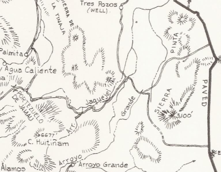
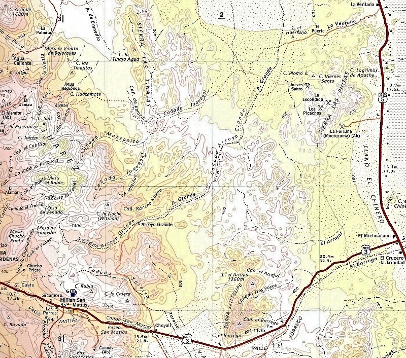
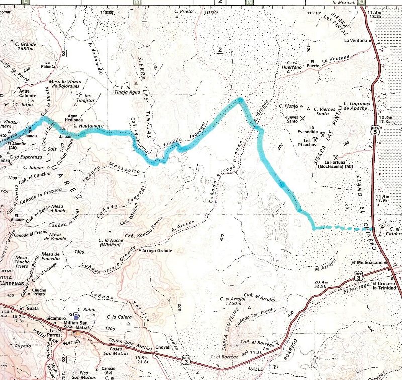
Is there a 2D map of the Pole Line Rd that could be posted here? DavidK?

1942 U.S. Pole Line Road

David K - 11-8-2013 at 10:35 AM

Quote:
Originally posted by redmesa
Is there a 2D map of the Pole Line Rd that could be posted here? DavidK?


redmesa - 11-8-2013 at 11:35 AM

Holy Cow, that is one off road path. I sure there is a history behind it that I have missed out on. Thanks David.

David K - 11-8-2013 at 11:47 AM

Quote:
Originally posted by redmesa
Holy Cow, that is one off road path. I sure there is a history behind it that I have missed out on. Thanks David.


There are big threads on it and the history, here on Nomad... I even found details on the American Radar Station the phone line went to, near San Felipe... Punta Estrella used to be called Punta Radar (next to Punta Diggs)... at least from one source. There's a story online from a guy who was a kid riding with his dad to San Felipe in WWII taking food supplies to the U.S. base there... long dirt drive from Calexico!

From the Internet...

David K - 11-8-2013 at 11:58 AM

1940's: Baja in WWII


Mexico and the Defense of California

American concern for the security of Mexico was intimately related to the extent and proximity of any threat to United States territory. After the attack on Pearl Harbor, the security of Baja California became a matter of acute interest to the United States. Just as lend-lease was a manifestation of American interest in the security of Mexico, so the measures taken by General DeWitt and General Card##as, singly and jointly for the defense of the United States' southwest and Mexico's northwest were concrete expressions of Mexican cooperation in the defense of the United States.

There were three fields of activity in which the defense of California involved joint action with Mexico: first, the placing of aircraft detector stations in Baja California; second, the building of airfields and highways there; and third, the formulation of joint plans by General DeWitt and General Card##as.

The proposal to establish radar stations in Baja California grew out of a study made by the GHQ Air Force early in 1941, disclosing that vital areas in the southwest, near the Mexican boundary, could not be adequately covered either by a ground observation system or by radar detectors in American territory.

"An enemy desiring to attack Southern California," a later Air Forces report stated, "may be expected to be aware of the limitations of our Aircraft Warning Service, and will make his approach over or from Mexican territory. " 74 The Air Forces therefore recommended taking steps to obtain Mexico's permission to establish at least two detector stations in Baja California.

These views were brought to the attention of the War Plans Division sometime in April. Without denying the merits of the proposal, the War Plans Division informed the Army Air Forces that the moment was not propitious for discussing the subject with the Mexican staff representatives, then in Washington.

The Air Forces continued to agitate the matter during the next three months, only to receive the same reply: "The War Department considers it inadvisable to submit to the Mexican representatives a request to station detachments of U.S. Army armed and uniformed forces in Mexican territory, as it is convinced that the Mexican Government would reject such a request at this time." 75 In framing the War Plans Division reply, Colonel Ridgway, then serving as one of the American staff representatives, noted, "there is no probability of securing Mexican consent . . . at least until an Axis attack is delivered or imminent." 76

No action was taken until 3 December 1941, four days before the attack on Pearl Harbor, when the American staff representatives presented their Mexican colleagues with a proposal for an immediate reconnaissance of Sonora and Baja California for the purpose of locating sites for radar stations. Although it was agreed that the necessity of using the installations might never arise, the American representatives nevertheless proposed that the preliminary steps be taken at once and that small mixed groups of United States officers and Mexicans, in civilian clothes, should survey the area within two hundred miles of the border for access roads and radar sites.77

An appeal on 8 December brought a reply from President Avila Camacho the same day giving full permission to make the reconnaissance and install the radar stations. To the original purpose the Air Staff had, however, added that of investigating rumors of Japanese airfields and fuel caches. A separate party under Maj. A. P. Ebright conducted the Air Staff survey, entering Mexico on 16 December. An attempt by the War Department to identify the Ebright mission with the radar station reconnaissance no doubt contributed to the initial confusion and suspicion that attended it.78

Although no signs of enemy activity were uncovered, the Ebright party remained in Mexico until the end of January to investigate suitable sites for landing fields, to report on the availability of water and other supplies along the route of communications from the border south, and in general to add to the Army's store of information about the area.79 As the immediate post-Pearl Harbor frenzy subsided and as the scope and positions of the Ebright mission became clarified,

[357]


--------------------------------------------------------------------------------

General DeWitt's Western Defense Command headquarters gave it firmer support against the continued skepticism at the headquarters of the Southern California Sector.80 Meanwhile, other groups had crossed the border, and had tentatively chosen sites for radar detector stations at Punta Salispuedes, 20 miles northwest of Ensenada; Punta San Jacinto, 125 miles south of Ensenada; and Punta Diggs on the northeast coast of the peninsula.

With all this activity going on, the issue that had threatened the negotiations over staging fields the previous summer-whether Mexico would permit the entry and stationing of armed and uniformed American soldiers promised to become a hardy perennial. On the earlier occasion, it had been solved by accepting the Mexican position, and when the proposal for the reconnaissance of Baja California was presented to the staff representatives on 3 December the wearing of civilian clothes by the soldiers making the survey was accepted by the American representatives as inescapable.

The first draft of the instructions for `the reconnaissance, drawn up on 9 December for the Chief of the Army Air Forces, stated, "United States personnel will be limited to officers and they will wear civilian clothing," but at the suggestion of G-2, and with the concurrence of Colonel Ridgway, this particular restriction was deleted.81

Because of the United States' belligerent status, it was no longer appropriate. General DeWitt was especially insistent that no soldiers cross into Mexico unless in uniform and armed, but the point was not raised with Mexican representatives in Washington.

Consequently, the Ebright group was turned back at the border and not permitted to cross until the men changed into civilian clothing and left their weapons behind. Sometimes, depending on the attitude of the local Mexican commanders, American parties were permitted to enter the country in uniform, but never under arms, and not even the excellent personal relations that existed between General DeWitt and General Card##as could bring about a definite acceptance of the American view.

The War Department as well as the Department of State took the position that, unsatisfactory though it might be to send American soldiers into Mexico in civilian clothes and without arms, to arrive at an impasse with Mexico and risk having permission to install the radar sets refused would be even more undesirable.

Accordingly, on 20 December General DeWitt was authorized to accede to Mexican wishes in the matter. His efforts to obtain a less dangerous and more face-saving solution continued but met with slight success.82 After the summer of 1942 this particular issue ceased to be a matter of record. The establishment of the radar stations, a diminution of American activity in Baja California, and the withdrawal of American personnel were probably responsible.

Two of the radar stations were set up and began operations during the first week in June 1942 and the third a month later. At each, one officer and twenty-five enlisted men were stationed to operate the set and train Mexican military personnel in its use.

The equipment itself was turned over to the Mexican Army under lend-lease. By the end of August the Mexican troops had taken over the operation of the sets, and the Americans had withdrawn except for a small detachment of five men and one officer at each station.83

The coverage provided by the three sets was far from complete, but even as early as October 1942 the War Department was breathing more easily and saw no need to install additional equipment. 84

By the summer of 1943 retrenchment had become the order of the day in Baja California. All Americans were withdrawn from the radar stations except for one officer and three enlisted men, who were left in Ensenada primarily for liaison purposes. All requests for additional equipment had to be refused.

By mid-May 1944 the Commanding General, Fourth Air Force, reported that he no longer considered the three radar stations necessary for the defense of California and, much to the dismay of both Navies, who wished to have the sets in operation for air-sea rescue work, operations ceased about the first of June.

When, at a meeting of the defense commission, Admiral Johnson protested against a Mexican Army proposal to move the equipment to Mexico City, General Henry was obliged to state that the War Department's policy of retrenchment remained unchanged but that there would be no objection to the Navy's supplying and maintaining the operation of the sets.

For the remainder of the war, the Army had no further responsibility in the matter. One station resumed operation with gasoline and oil supplied by the Navy. The other two were moved away.85

During the two years they had been in operation, the stations performed a useful function. They had closed all but a small gap in the network around the San Diego-Los Angeles area. Anticipated language difficulties failed to materialize to any great extent, and valuable training in the use of highly technical equipment was given our Mexican ally.

As part of the general scheme of filling in the gaps in the defenses of California after the attack on Pearl Harbor, the Fourth Air Force had strongly urged the building of three landing fields for pursuit planes in Baja California and two staging fields, one near Rosario and the other near La Paz. Time, and authority to use the fields for operations, were the important considerations. Both the War Department and the joint defense commission, when formally constituted, were agreed upon the desirability of the proposal, which the commission adopted as its Fourth Recommendation on 10 April 1942.86

After some backing and filling a joint survey got well under way and recommended three sites as primary airdromes-El Cipres, six miles south of Ensenada; Camalu, just south of San Jacinto; and Trinidad, about eighteen miles south of La Ventura. 87

Later, four other fields were surveyed. For three weeks at the end of June and in early July the War Department, on the advice of the joint defense commission, called a halt to all activity in connection with the airfields in order to give Mexican opinion time to crystallize and to give General Card##as an opportunity to make a decision.

After authority was given to proceed with the plans and estimates for the original five airfields, General Card##as and especially General Juan Felipe Rico, the local Mexican commander, took hold of the project with enthusiasm and pushed not only the airfields but also a connecting highway down the peninsula.

General DeWitt promised any help in materials and equipment that General Rico might need. The United States, General DeWitt thought, was committed to assist both projects, the roads as well as the airfields.88

By the beginning of 1943, the War Department had begun to cool, although the Fourth Air Force still urged that the three northern fields, at El Cipres, Camalu, and Trinidad, be constructed and tied to San Diego by connecting roads. In March the War Department rejected General Rico's request for materials and equipment for the construction of the airfields.

The Mexican section of the joint commission thus found itself in the position, in August, of arguing in favor of the United States Army undertaking a defense construction project on Mexican soil, while the American section was opposed. With the War Department unwilling to provide the construction materials because of the urgent needs of more active theaters of operations, the discussion became academic.89

In the field of joint planning, the Mexican experience took a contrary course to that of Canadian-United States planning. In the case of the latter a basic plan was drawn up by the Permanent Joint Board, and local joint plans, more detailed and specific, were subsequently completed in accordance with its general principles.

With Mexico, on the other hand, the only joint plan completed during the war was the DeWitt-Card##as plan of February-March 1942 for the defense of the Pacific coastal region. When later the joint defense commission undertook to draw up a plan, two of the members-Admiral Johnson and General Castillo Najera-understood that the commission was supposed to base its plan on the DeWitt-Card##as agreements.

A casual observer would perhaps have seen little in the local situation to indicate much success for the Western Defense Command planners. The local Mexican commanders either were uncertain of their authority to commit the federal government or were reluctant to accept instructions from Mexico City; the difficulties and delays in obtaining full permission for a reconnaissance in Baja California were inauspicious. But such an observer would have been wrong. Actually, the Mexican commanders made clear their willingness and desire to cooperate, and if they were reluctant to place their names to a document committing them to joint action, they made it plain by word of mouth that in an emergency they would call on General DeWitt to send American troops into Mexico.

In its final shape the plan represented a compromise between an earlier draft drawn up by General DeWitt's headquarters and one presented by General Card##as.90 It provided for the patrol and defense of the two coastal areas-Mexican and American-by the forces of the respective countries, for an exchange of information between the two forces, and for the passage of troops of either country through the territory of the other; and it permited
the forces of either country to operate in the other, in uniform and under arms. There were several provisions that failed to meet with the approval of General Card##as.

The Mexican commander could not agree to the control and operation of airfields and radar stations in Mexico by American personnel, and insisted that the forces of one country operating in the territory of the other be under the commander in whose area they were operating.91

Both generals agreed that the plan was sound from a "military standpoint" and that "the question from a nationalistic standpoint is one for the decision of the two governments." 92 The points on which the two commanders could not agree were accordingly turned over to the joint defense commission.

The American section thought it best to defer consideration of a general, basic plan until such specific matters as the radar stations and airfields were agreed upon, and when the draft of a basic plan was presented by Col. Lemuel Mathewson at the meeting of 21 April 1942, it was patterned after the Canada-United States Basic Defense Plan of 1940.93

Little progress had been made when Admiral Johnson, becoming chairman of the American section, suggested a fresh start and a new approach. This was in December 1942. The new scheme-to draw up a plan of collaboration, in ratification of the agreements reached by the commission, instead of a defense plan-was no more easily agreed upon than the old.

General Henry, recently appointed senior Army member, took over the job of drafting a new plan in collaboration with General Alamillo of the Mexican section. Discussion during the meetings the following summer and fall reveal what seem to be a measure of impatience and perhaps satiation. The question of command proved to be the stumbling block, and by April 1944 General Henry was ready to abandon the attempt to write an acceptable plan. Finally, after more than two years of effort, the commission decided upon a "statement of general principles . . . which might serve as a basis for other plans of collaboration between any two nations." 94

In a broader sense, the wartime collaboration between the United States and Mexico cannot be measured adequately by the activity in Baja California, by the joint planning of General DeWitt and General Card##as, by the deliberations of the defense commission, or by the airfields provided from Tampico to Tapachula. All of these might well have created dissension. But from the early wartime experience came a closer bond between the two countries.

The commendable combat record of the Mexican 201st Fighter Squadron on Luzon, the Mexican airmen who gave their lives in the same cause for which American fliers died, these were the true measure of the cooperation that began in 1941.

There were indications that ties so strongly forged would not be lightly dropped. Although the joint defense commission had not been formally designated as a permanent body, plans were made at a staff conference in March 1945, at which the American members of the commission represented the United States, to continue the defense commission in the postwar years. The mutual confidence and respect between the two countries that developed out of their wartime association are proof that the New World can still serve as a beacon for the Old.

------------------------------------------------------------------------------------------

From Gene Kira's MexFish.com


MILK RUN” (LITERALLY)

“The first trip I made to San Felipe in Mexico was to deliver dairy products to the Army radar station in the spring of 1942.

“Sometime, in about April I think, my dad pulled me out of the second grade, and we got into a 1938 Dodge truck and headed for San Felipe.

“The truck was filled with milk, butter, eggs, cheese and ice cream and we were headed for the army ‘base’ at San Felipe.

“Because of the war, there was a 35 m.p.h. speed limit, and we spent the night at Calexico, at the Anza Hotel, I think.

“We got up early the next morning. I don't remember having to stop going in either direction at the border. We crossed at Calexico and it was marked as the border, but I don't think there was any official border activity.

“We were not far out of town, across the border, when we were stopped at the first of maybe four check points before we reached San Felipe. These stops were manned by American soldiers, not Mexicans.

“My dad explained that we were going to a military installation in San Felipe that had just been built, and what it did was listen for airplanes using something called ‘radar.’ In the last six months, the Army had built a paved road to San Felipe called the ‘radar road’ which made the drive south a lot easier than it had been, unlike the month-long ordeal of mud and flood up until 1942.

“What we drive on today is the ‘radar road,’ although it has been paved a couple of times since then.

“I may be the only person to remember driving on that stretch of road during World War II who is still alive today. I can remember, the water was right up to the road's edge in places, and my dad said that if it were not for the road, we'd have to wait for the tides to change and for the mud to dry out.

“The ‘base’ was near where the old icehouse was until recently, and we were stopped from driving into the main area. About 20 young soldiers came out to the barbed-wire fence and had the truck unloaded in a very short time, and we turned right around and headed home.”

------------------------------------------------------------------------------------------

American WWII Air Defense Radar Stations
(1942 - 1943), State of Baja California (Norte)

During the early years of WWII the U.S. Army built and manned at least three SCR-270 early warning anti-aircraft radar stations along the coast of Baja California Norte, operated by the 654th AWS Company, to protect the southern approaches to San Diego, California.

Known sites include Station B-92 at Punta Salispuedes, located 22 miles northwest of Ensenada (later moved to Alasitos, 36 miles south of Tijuana); Station B-94 at Punta San Jacinto, 60 miles south of Ensenada; and Station B-97 at Punta Estrella (Diggs), south of San Felipe on the Gulf of California (aka Sea of Cortez).

SCR-270 Radar

David K - 11-8-2013 at 12:02 PM


One Tough Trail... Neal Johns in Discover Baja:

David K - 11-8-2013 at 12:05 PM

Quote:
Originally posted by Ken Cooke


Ken Cooke - 11-9-2013 at 06:42 AM

Quote:
Originally posted by Neal Johns
Ken,
What is the deal on the new gate? at the bottom of Summit (entrance to PLR west)?
Neal


Neal - There are a number of gates (approximately 3) which crisscross the Pole Line Trail from the Summit Road to the White Tank, as different ranches' property boundaries cross the trail.

David K - The most expensive camp space - La Cabaña can cost that amount for just one night ($155+). I would prefer to see a new locale - for no money down, with approved Jeep!:lol:

David K - 11-9-2013 at 08:47 AM

Never heard of La Cabaña before... must not be in Arturo's original area? Have fun Ken...

Ken Cooke - 11-9-2013 at 09:33 AM

Quote:
Originally posted by David K
Never heard of La Cabaña before... must not be in Arturo's original area? Have fun Ken...


For the less-equipped group driving in a Subaru, Highlander, New Beetle, etc., this is a great destination.

http://www.guadalupecanyonoasis.com/LaCabana.html


Neal Johns - 11-9-2013 at 11:55 AM

Ken,
The gates are new to me - locked, unlocked???
Neal

Ken Cooke - 11-9-2013 at 12:59 PM

Quote:
Originally posted by Neal Johns
Ken,
The gates are new to me - locked, unlocked???
Neal


Completely new to me, too.

CG opening the first (unlocked) gate.


Me opening the gate leading to the sandy wash below the Summit grade.


Entrance to the Pole Line Road (open/unlocked)


Cattle gate along the Pole Line Road before reaching the White water tank.


Wondering if the Chevy Avalanche is still there?

Ken Cooke - 11-9-2013 at 01:05 PM


[img]https://scontent-b-sjc.xx.fbcdn.net/hphotos-prn1/164239_509259665797588_1879978510_n.jpg?lvh=1[/img]


David K - 11-9-2013 at 01:56 PM

So that's were stolen Chevy's from Temecula end up?!!

Neal Johns - 11-10-2013 at 10:12 AM

Thanks, Ken. Good maps, DK.
Neal

BAJACAT - 11-12-2013 at 10:21 PM

any leads on that Avalanche..

Update

Ken Cooke - 11-16-2013 at 09:44 AM

Palomar Canyon - The Summit - Cañon Jaquegel (Climb, Hike, and 4x4)

The Pole Line Group has been assembled with drivers coming in from Tijuana, B.C., the Los Angeles area, Inland Empire, and even Phoenix, Arizona! Our group will leave Calexico next Saturday (Nov. 23rd) at 10:30 a.m. and will return to the Estados Unidos (USA) on Tuesday evening - Nov. the 26th.

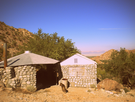
Because there was some concern over the one-night $155 Guadalupe Canyon campground deposit, our group will instead travel 24 additional miles south to the rocky, off-road trail of Palomar Canyon featuring a man-made warm spring combined with a cold spring-fed river running beside it overlooking the Laguna Salada and the Cohabuzo Junction-area.

Guadalupe is still a great choice for a weekend trip to the Laguna Salada area, but on holiday weekends, improved campground sites run $100+/night. Palomar Canyon offers improved man-made hot springs w/hot tub without camp fees, but a challenging Level 2 trail to reach it.

Before we hit the dirt, there is an incredible Taco place along Hwy 2 in El Progreso on the outskirts of Mexicali where we will have brunch! Can't wait!! For more info, send a text or call.

Leader – Ken Cooke – cell (951) 255-1589
Dates – November 23 – 26, 2013
Meeting Time – 10 AM
Depart – 10:30 SHARP
Meeting Place – Pep Boys - 400 Imperial Ave Calexico, CA 92231
Difficulty Rating – 2 http://www.justruns.com/files/dif.htm
Brunch (11 AM) – Great Taco place in El Progreso (along Hwy 2)
Mexican Travel Insurance is required for your vehicle for street travel through the Mexicali-area.
Note: “Off-Road Travel” is not covered on Mexican Travel Insurance Policies.
Communications – CB 14
Trip Type – Bobtail Camping (pack for cold nights) – 2 Gerry Cans and a full gas tank in Progreso are required.

David K - 11-17-2013 at 10:41 AM

Have a great time Ken...

Can you take photos of any remaining 1942 telephone poles, and any cobblestone roadbeds... please!?

BAJACAT - 11-17-2013 at 08:10 PM

can wait to see El Palomar, pix will do for me..I got to go back..one of this days.have fun Ken and have fun..I never made it to the petros, so I can help you there..

Ken Cooke - 11-17-2013 at 10:41 PM

Less than 1 week to go, and our group of 5 Jeeps (4 built Wranglers and 1 built XJ Cherokee) are ready to go. I will attempt to take photos on the last day (Tues.) as we had out past the Sierra Las Tinajas towards Ejido Saldana. There are some telephone poles that are a long distance away from the trail to the north close to Canon Jaquegel.

I will take a look for the petros, BajaCat. This should be interesting since everyone will be visiting Canon Palomar for the first time. Can't wait!

Neal Johns - 11-19-2013 at 03:57 PM

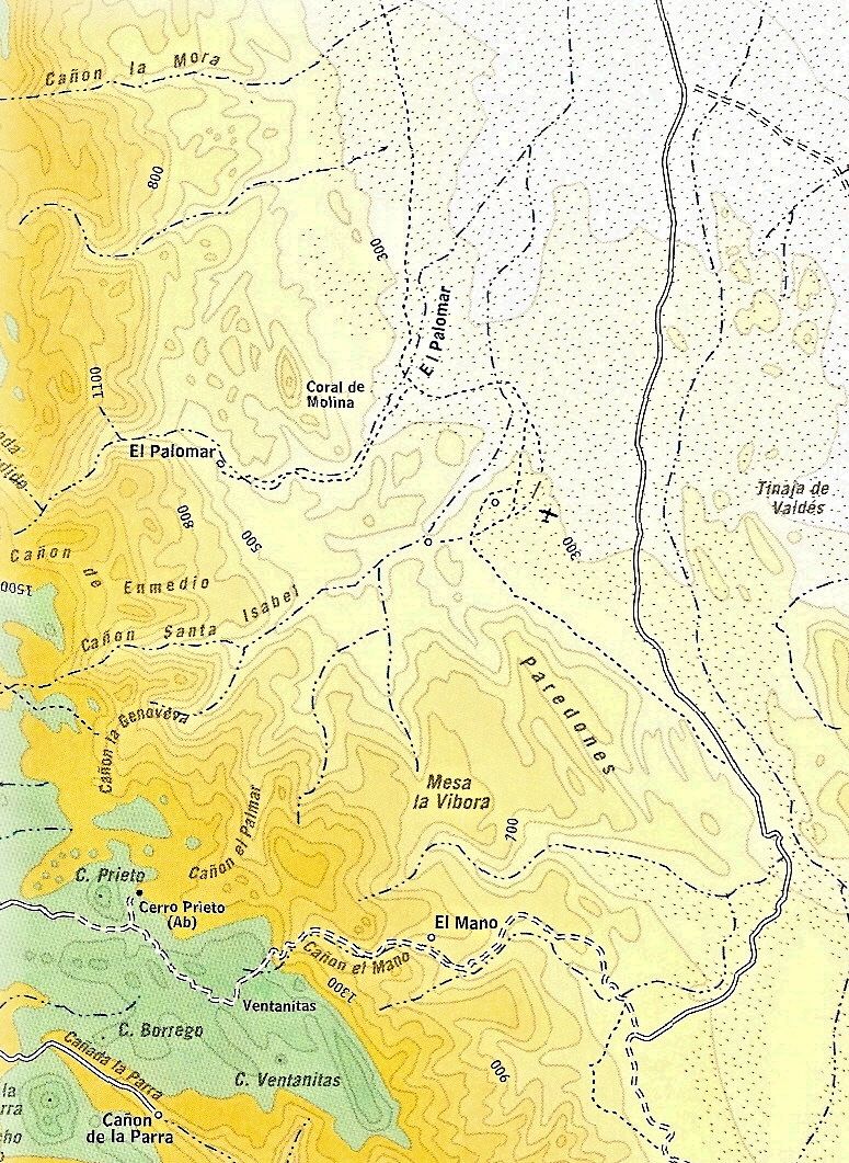
Ken, first time at Palomar, eh? Hot tip: When you enter the palm grove near the house, the regular straight trail frequently gets quite boggy. If so, wind your way through the palms on the right. Don't ask me how I know. Also, the plastic hose from the hot spring down to the built pool sometimes is missing.

Check the stream bed near the house for bedrock grinding slicks.
Neal

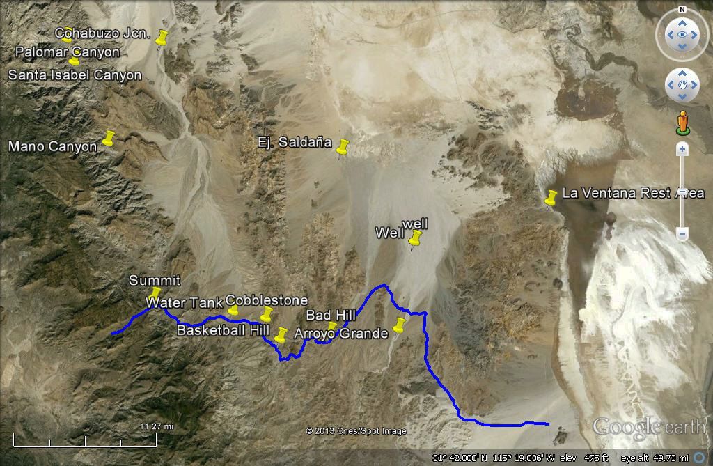
Palomar, Santa Isabel, Mano Canyons:

David K - 11-19-2013 at 06:43 PM


Thanks Neal and David K for the info!

Ken Cooke - 11-19-2013 at 09:11 PM

Quote:
Originally posted by Neal Johns
Ken, first time at Palomar, eh? Hot tip: When you enter the palm grove near the house, the regular straight trail frequently gets quite boggy. If so, wind your way through the palms on the right. Don't ask me how I know. Also, the plastic hose from the hot spring down to the built pool sometimes is missing.

Check the stream bed near the house for bedrock grinding slicks.
Neal


4 more days - the Wife and I are both excited about this run. 5 Jeeps, lots of fun times and great food to look forward to.:bounce:

This place makes great Chicken tacos - the marinade and smoked flavor were incredible

Ken Cooke - 11-19-2013 at 10:19 PM


Waiting in line...November 2011


[Edited on 11-20-2013 by Ken Cooke]

vacaenbaja - 11-22-2013 at 05:51 PM

Too much road for a stock 1987 pathfinder with 31/10.50 4x4?

Taco de Baja - 11-22-2013 at 06:05 PM

Quote:
Originally posted by vacaenbaja
Too much road for a stock 1987 pathfinder with 31/10.50 4x4?


A stock 2010+/- Tacoma 4-door; a stock 2010 Toyota FJ, and a lifted 1996 Tacoma all made it....barely. All have the equivalent of 31/10.5, all are 4x4, and none have lockers that I know of. Would I do it again?....Maybe, but I'd spend more time than the 2-day run we did it in.

We definitely had to move rocks and pick the routes very carefully.

Ken Cooke - 11-22-2013 at 07:30 PM

Quote:
Originally posted by vacaenbaja
Too much road for a stock 1987 pathfinder with 31/10.50 4x4?


Under normal conditions - no. With all of the rain and snow in the area, the conditions will go from moderate to black diamond. I will report back next week on how it all went down.

PaulW - 11-23-2013 at 10:06 AM

Sure would be nice is someone in your party would make a GPS track for those who cannot join you all
thanks, Paul

Ken Cooke - 11-27-2013 at 10:55 PM

Quote:
Originally posted by PaulW
Sure would be nice is someone in your party would make a GPS track for those who cannot join you all
thanks, Paul


Hi Paul,

Our route changed considerably due to rainy conditions on the Laguna Salada that literally flooded portions of it. We took an alternate route that proved just about as difficult as the Pole Line Road - be sure to check out my trip report in the Baja Trip Report section. My friend Victor took his GPS, but it was not set up for use in Baja.

[Edited on 11-28-2013 by Ken Cooke]

PaulW - 11-28-2013 at 08:51 AM

Hi Ken,
Yes, they have rerouted the CODE race due to all the rain.
Since I am in San Felipe I only care about the PLR route south of the La Ventana access.
You all experienced the Salida glue. Get it off before it sets up.
Ha.
Paul
=========
Quote:
Originally posted by Ken Cooke
Quote:
Originally posted by PaulW
Sure would be nice is someone in your party would make a GPS track for those who cannot join you all
thanks, Paul


Hi Paul,

Our route changed considerably due to rainy conditions on the Laguna Salada that literally flooded portions of it. We took an alternate route that proved just about as difficult as the Pole Line Road - be sure to check out my trip report in the Baja Trip Report section. My friend Victor took his GPS, but it was not set up for use in Baja.

[Edited on 11-28-2013 by Ken Cooke]

Ken Cooke - 11-28-2013 at 09:17 AM

Quote:
Originally posted by PaulW
Hi Ken,
Yes, they have rerouted the CODE race due to all the rain.
Since I am in San Felipe I only care about the PLR route south of the La Ventana access.
You all experienced the Salida glue. Get it off before it sets up.
Ha.
Paul
=========
Originally posted by PaulW


The Pole Line Road (Datum is WGS84)
GPS Waypoints to show the way.

Description Mileage Latitude(north) Longitude (West)

Hwy 2/Graded Road to
Guadalupe Canyon 0.0 N32 34.572 W115 44.673

Turnoff to Guadalupe
Canyon (continue straight) 27.0 N32 13.063 W115 42.283

Cohabuzo Junction 57.0 N31 55.744 W115 36.263

El Mano Junction
(continue straight) 71.0 N31 49.814 W115 33.932

Summit Trail/Beginning
of Pole Line Trail 83.0 N31 37.848 W115 35.754

“Y” (Go Left) 86.0 N31 36.499 W115 33.438

White H20 Tank 91.0 N31 36.822 W115 30.070

Hand-laid Cobblestone 92.0 N31 36.636 W115 27.848

Cobblestone Hill 94.0 N31 36.377 W115 27.443

Basketball Hill turnoff 96.4 N31 34.935 W115 26.281

Cyn. Jaquegel Wash 97.2 N31 34.128 W115 25.438

Exit Jaquegel Wash 101 N31 35.741 W115 23.128

Rutted/Off-camber Hill 102.5 N31 35.268 W115 22.519

Top of off-camber Hill 102.7 N31 35.327 W115 22.255

Rocky hill leading to mouth
of Cyn. Jaquegel 104.5 N31 36.168 W115 21.050

“T” Intersection – go left
towards Ejido Saldana 109 N31 39.041 W115 18.217

Road into wash 112.5 N31 39.732 W115 18.800

2WD Pickup road to 112.7 N31 44.431 W115 19.226
Ejido Saldana/Hwy 5
(Travels north then west
before turning east towards
Hwy 5)

Ejido Saldana/Highway 5 130.5 N31 51.754 W115 10.962

[Edited on 11-28-2013 by Ken Cooke]

Code Off Road: Laguna Salada - 'No Access'

Ken Cooke - 11-28-2013 at 09:21 AM