BajaNomad

Baja 1000 Route?

Bajaboy - 7-17-2016 at 02:23 PM

Starting to get excited for this year's 1000. Does anyone know approximately when a route/map will be available? Thanks in advance.

zac

StuckSucks - 7-17-2016 at 02:40 PM

Figure a month out to see maps or GPS files. Visit Race-Dezert.com and there will be course speculation months out. It's a loop this year, from Ensenada to Ensenada.

Bajaboy - 7-17-2016 at 02:45 PM

Quote: Originally posted by StuckSucks  
Figure a month out to see maps or GPS files. Visit Race-Dezert.com and there will be course speculation months out. It's a loop this year, from Ensenada to Ensenada.


Thanks! I used your map last year to dial in a great spot near El Rosario. I'll keep a look out.

woody with a view - 7-17-2016 at 02:47 PM

Zac, they turn and head back up at either Chapala or just north of BdeLA. Hint, hint!

TMW - 7-17-2016 at 02:50 PM

The map will be at the Off Road Expo in Pomona Oct 1&2.

http://www.offroadexpo.com/

StuckSucks - 7-17-2016 at 02:52 PM

For hormonal purposes, here's another peek at the 2015 Baja 1000 Course Map.

Ateo - 7-17-2016 at 03:46 PM

I'll be down watching the race with friends.........hopefully somewhere on the Pacific Coast!

David K - 7-17-2016 at 03:56 PM

Consider also that there are no parallel routes to the new highway between Matomi area and Chapala other than short sections of the older road where the new one is not over it. I guess running Calamajué Canyon is out, too... environmental issues are important now after that canyon was first used for the 1000 in 1973 and again in 1979 the second time, and often after that.

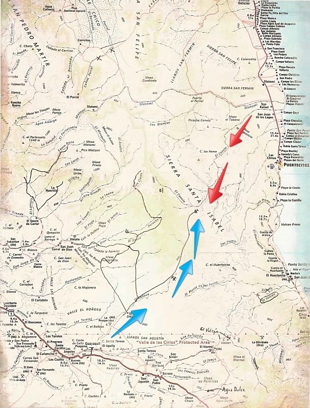
It would be great to open a road from the mine, way north of Rancho El Aguila (near San Agustin/El Marmol jcn.) over to the Matomi arroyo area north of Puertecitos. It would be a huge shortcut between the gulf and Pacific sides and give racers a loop route off the highway! On the following Almanac map, I added lines by pencil to show roads seen from space, but not on the map...


Blue arrows is existing, graded mine road. Red arrows is arroyo travel up from Hwy. 5. Baja Lou and other have gone as far as possible until boulders blocked the way short of reaching the mine road.

ehall - 7-17-2016 at 06:09 PM

David, I was looking at that exact route on google earth. I was going to attempt it in my jeep but after reading this I might take my bike instead.

Bajaboy - 7-17-2016 at 06:31 PM

Quote: Originally posted by woody with a view  
Zac, they turn and head back up at either Chapala or just north of BdeLA. Hint, hint!


Our plan is hopefully catch them on the Pacific headed south. Then head to our place to load up on tuna/jurel. You should clear the calendar!

BigBearRider - 7-17-2016 at 06:57 PM

Quote: Originally posted by StuckSucks  
Figure a month out to see maps or GPS files. Visit Race-Dezert.com and there will be course speculation months out. It's a loop this year, from Ensenada to Ensenada.


It's a loop this year again?

[Edit] I guess that is what the website says. I thought it was going to alternate, every other year a loop.

[Edited on 7-18-2016 by BigBearRider]

[Edited on 7-18-2016 by BigBearRider]

ehall - 7-17-2016 at 07:42 PM

Loop again because next year will be a big one. An anniversary run.

willardguy - 7-17-2016 at 08:20 PM

Quote: Originally posted by ehall  
Loop again because next year will be a big one. An anniversary run.


maybe 2K!

micah202 - 7-18-2016 at 07:29 AM

Quote: Originally posted by ehall  
Loop again because next year will be a big one. An anniversary run.


...doing a loop course would save a LOT of fuel between all the racers and support vehicles.
.....not so much if you live in Cabo though <;-/


[Edited on 7-18-2016 by micah202]

David K - 7-18-2016 at 08:02 AM

Quote: Originally posted by ehall  
David, I was looking at that exact route on google earth. I was going to attempt it in my jeep but after reading this I might take my bike instead.


Some past discussions on that route:
http://forums.bajanomad.com/viewthread.php?tid=22907
http://forums.bajanomad.com/viewthread.php?tid=44127

TMW - 7-18-2016 at 08:08 AM

["It would be great to open a road from the mine, way north of Rancho El Aguila (near San Agustin/El Marmol jcn.) over to the Matomi arroyo area north of Puertecitos. It would be a huge shortcut between the gulf and Pacific sides and give racers a loop route off the highway! On the following Almanac map, I added lines by pencil to show roads seen from space, but not on the map..."]

I tried going thru there starting at the north end a few years ago and ran into large rocks and deep sand, I didn't get vary far. I think Bajalou tried it in a sand rail and had the same issues.

I think they will run the 2015 course backwards with a few changes.

From what I've heard 2017 will be somewhat like the 2000 race. A long race to celebrate the 50th anniversary.

David K - 7-18-2016 at 08:27 AM

Quote: Originally posted by TMW  
["It would be great to open a road from the mine, way north of Rancho El Aguila (near San Agustin/El Marmol jcn.) over to the Matomi arroyo area north of Puertecitos. It would be a huge shortcut between the gulf and Pacific sides and give racers a loop route off the highway! On the following Almanac map, I added lines by pencil to show roads seen from space, but not on the map..."]

I tried going thru there starting at the north end a few years ago and ran into large rocks and deep sand, I didn't get vary far. I think Bajalou tried it in a sand rail and had the same issues.

I think they will run the 2015 course backwards with a few changes.

From what I've heard 2017 will be somewhat like the 2000 race. A long race to celebrate the 50th anniversary.


Yes, in the links I posted just above, we are talking with bajalou about it. We just need to borrow the dozer the mine used for a couple days!

woody with a view - 7-18-2016 at 10:15 AM

Quote: Originally posted by Bajaboy  
Quote: Originally posted by woody with a view  
Zac, they turn and head back up at either Chapala or just north of BdeLA. Hint, hint!


Our plan is hopefully catch them on the Pacific headed south. Then head to our place to load up on tuna/jurel. You should clear the calendar!


Only problem is they use the km252 road as race course. Thats our way in and out without having to traverse the dreaded silt beds to head south and out. When are the run dates?

Bajaboy - 7-18-2016 at 08:24 PM

Quote: Originally posted by woody with a view  
Quote: Originally posted by Bajaboy  
Quote: Originally posted by woody with a view  
Zac, they turn and head back up at either Chapala or just north of BdeLA. Hint, hint!


Our plan is hopefully catch them on the Pacific headed south. Then head to our place to load up on tuna/jurel. You should clear the calendar!


Only problem is they use the km252 road as race course. Thats our way in and out without having to traverse the dreaded silt beds to head south and out. When are the run dates?


The weekend before Thanksgiving.

woody with a view - 7-18-2016 at 08:35 PM

Not agood time for us. Maybe but prolly not.