| Pages:
1
..
5
6
7 |
pacificobob
Super Nomad

Posts: 2242
Registered: 4-23-2006
Member Is Offline
|
|
It never fails to amaze me how little locals know about the history of their area. Even current knowledge about areas 25kms from their place of birth.
We were exploring (ok, half lost) on motorbikes about 100km south of batopilias Chihuahua and came to a settlement of about 30 indigenous folks. When
i asked the name of the river that they lived on, i got the deer in the headlights look. Their only response was "the river".
Locally, here in South baja simple questions like , when did electricity come to the village?, where did your grandparents get water? Go unanswered or
with vague answers..... And minimal curiosity.
|
|
|
David K
Honored Nomad
Posts: 64493
Registered: 8-30-2002
Location: San Diego County
Member Is Offline
Mood: Have Baja Fever
|
|
Good point, Bob.
I am also amused that they rarely give names to hot springs, other than calling them 'Agua Caliente'...
|
|
|
mtgoat666
Select Nomad
Posts: 17348
Registered: 9-16-2006
Location: San Diego
Member Is Offline
Mood: Hot n spicy
|
|
Quote: Originally posted by pacificobob  | It never fails to amaze me how little locals know about the history of their area. Even current knowledge about areas 25kms from their place of birth.
Locally, here in South baja simple questions like , when did electricity come to the village?, where did your grandparents get water? Go unanswered or
with vague answers..... And minimal curiosity. |
If you ask me when electricity came to my town, i would not know…
Why are you asking locals inane questions about dates of infrastructure construction?
Woke!
“...ask not what your country can do for you – ask what you can do for your country.” “My fellow citizens of the world: ask not what America
will do for you, but what together we can do for the freedom of man.”
Prefered gender pronoun: the royal we
|
|
|
4x4abc
Ultra Nomad
Posts: 4175
Registered: 4-24-2009
Location: La Paz, BCS
Member Is Offline
Mood: happy - always
|
|
| Quote: Originally posted by mtgoat666 |
If you ask me when electricity came to my town, i would not know…
Why are you asking locals inane questions about dates of infrastructure construction?
|
remember your first car?
the year you got it?
good!
many places in Baja never had power (many still don't)
finally getting power is likely like getting your first car
but it could be that the Baja people don't really care much
they don't have money to buy anything that runs on power
except maybe light bulbs
for those the government had a free solar project in the 1990's for even the remotest places - you got a solar panel, a battery and one light bulb.
remember the days when in Bahia de los Angels the power went out at 10pm?
when the machinist was drunk it would not come on the next day
or when they were out of diesel (happened often) there was no power for weeks.
those days when the light stayed on past 10pm were sad days
it meant that someone had died
the corpse was stored in the walk in freezer at Guillermos and it needed to be kept cold over night
Harald Pietschmann
|
|
|
mtgoat666
Select Nomad
Posts: 17348
Registered: 9-16-2006
Location: San Diego
Member Is Offline
Mood: Hot n spicy
|
|
I have talked with quite a few locals who know their land well, the natural history, human history, etc.
it is sad you arm chair google earth travelers are writing off locals as ignorant bumpkins.
Woke!
“...ask not what your country can do for you – ask what you can do for your country.” “My fellow citizens of the world: ask not what America
will do for you, but what together we can do for the freedom of man.”
Prefered gender pronoun: the royal we
|
|
|
4x4abc
Ultra Nomad
Posts: 4175
Registered: 4-24-2009
Location: La Paz, BCS
Member Is Offline
Mood: happy - always
|
|
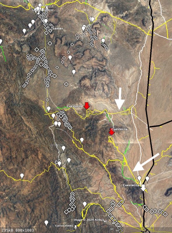
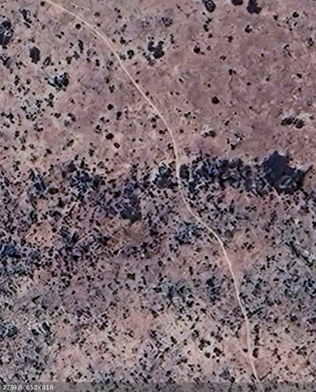
here is what i have so far
white blobs are water sources
the diamond signs are traces of trails
the yellow lines are trails wide enough for vehicles
the white lines are well established mining foot trails
many of them now used by MC groups
the red arrows are the high points of the trail
straight south from Leon Grande is very rugged - not likely
SE from Leon Grande is mountainous with deep canyons - not likely
only east has the terrain described in the report - very likely their path
the 2 high points kinda match
there are 2 sections of dead straight roads for the last part of the journey (long arrows)
the northernmost is likely the one as I understand they did not follow it
[Edited on 4-26-2024 by 4x4abc]
Harald Pietschmann
|
|
|
4x4abc
Ultra Nomad
Posts: 4175
Registered: 4-24-2009
Location: La Paz, BCS
Member Is Offline
Mood: happy - always
|
|
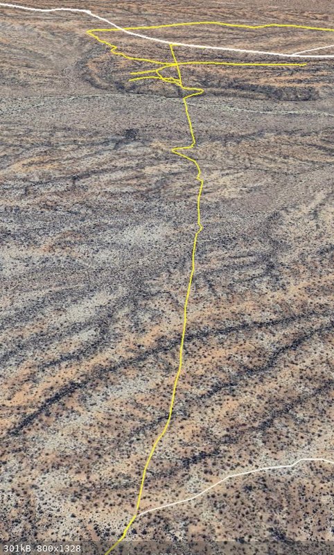
the northernmost straight road is not as dead straight as the Pemex trails from the 1950's - but very straight for Baja standards
Harald Pietschmann
|
|
|
David K
Honored Nomad
Posts: 64493
Registered: 8-30-2002
Location: San Diego County
Member Is Offline
Mood: Have Baja Fever
|
|
You have the old road to La Paz and the newer Baja 1000 road, both south from El Crucero, as white lines. These are auto roads, still. Just an fyi.
Otherwise, I love the work.
Can you add some kind of dashed line or other way to show us which lines you think Hale and friend hiked 100 years ago?
|
|
|
4x4abc
Ultra Nomad
Posts: 4175
Registered: 4-24-2009
Location: La Paz, BCS
Member Is Offline
Mood: happy - always
|
|
sorry - forgot to mention that
work in progress
the old Baja road is also in white
I have dash lines somewhere
Harald Pietschmann
|
|
|
Lance S.
Nomad
Posts: 152
Registered: 2-16-2021
Member Is Offline
|
|
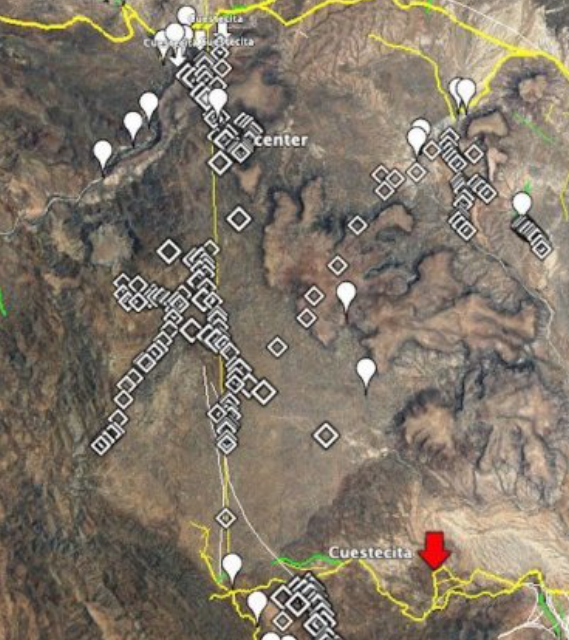
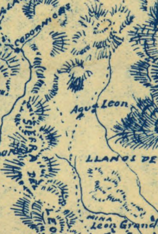
That's amazing work Harald, you can see the trail that branches off and heads over the Mesa to Agua Leon. You can even make out where the Y junction
was. Thank you!
|
|
|
4x4abc
Ultra Nomad
Posts: 4175
Registered: 4-24-2009
Location: La Paz, BCS
Member Is Offline
Mood: happy - always
|
|
the straight line you see in my image is, as I believe, a signal line
there is a peak visible almost all the way from Leon Grande north
perfect direction for Codornices
29°16'39.77"N, 114°18'3.59"W

Harald Pietschmann
|
|
|
4x4abc
Ultra Nomad
Posts: 4175
Registered: 4-24-2009
Location: La Paz, BCS
Member Is Offline
Mood: happy - always
|
|
there is some new MC activity in the area
someone laying out a new trail
MCs are very active in that part of the desert
29° 7'56.88"N, 114°16'29.19"W
Harald Pietschmann
|
|
|
bajaric
Senior Nomad
Posts: 606
Registered: 2-2-2015
Member Is Offline
|
|
| Quote: Originally posted by 4x4abc | there is some new MC activity in the area
someone laying out a new trail
MCs are very active in that part of the desert
29° 7'56.88"N, 114°16'29.19"W
|
I was wondering when you were going to spot that trail. It is a single track originating at Agua Leon and going around and over the west side of Mesas
Leoncito then south towards Leon Grande. The trail matches Hale's route, could it be an old burro trail?
As for Leon Grande, I can't see any trace of it. I think it was never more than a couple of shacks next to a tiny spring. A possible explanation of
its inclusion on so many maps would be that Goldbaum, being a mining guy, would have known the area due to its proximity to Mina Columbia, a big gold
mine just to the south. When he drew his map there were some Germans that were involved in mining at BOLA who were building a road to a proposed mine
in the Leon Grande area. It's possible that Goldbaum knew of their activity at Leon Grande and put it on his map during the brief period when it was
occupied by the Germans. The mine was a bust, and the Germans all went home when the war ended. Subsequent map makers all copied Goldbaum, making
Leon Grande seem more substantial than it really was.
Old abandoned mining camps are usually very hard to see on Google Earth. After 100 years anything that was built from wood is long gone. Only
foundations or structures that were built from stone or adobe can still be seen. For example, even Las Flores, a substantial mill site with many
buildings can barely be seen on the satellite view. Everything is gone except one stone building. Same for Las Arrastras, Molino de Lacy, El
Crucero, La Milla, etc. These were all mining camps / mills built near a well or water source. The early Baja map makers always showed these camps on
their maps because they were inhabited places with water. Leon Grande, being a tiny camp, is understandably invisible.
[Edited on 4-28-2024 by bajaric]
|
|
|
| Pages:
1
..
5
6
7 |


