David K
Honored Nomad

Posts: 65509
Registered: 8-30-2002
Location: San Diego County
Member Is Offline
Mood: Have Baja Fever
|
|
GONZAGA BAY SIDETRIPS
Seems a lot of interest in Gonzaga Bay on Nomad lately...
Besides fishing and beach activities there are many sites near the bay that are worthy of exploring... You know, when it's too windy to be on or near
the water!
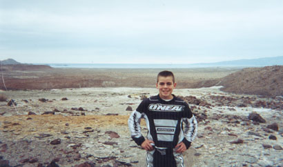
Over Thanksgiving, 2002, my (then) almost 14 year old son (on his motor bike) and I visited some!
South of Gonzaga, we popped up the 3 mile road into La Turquesa Canyon to the Green Pools...
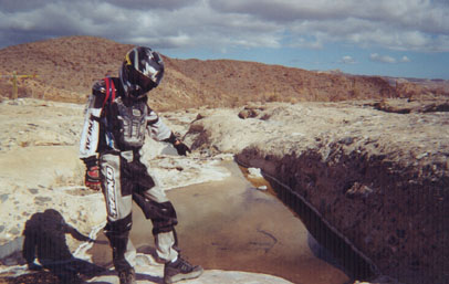
Green Pools N29°33.72' W114°23.89'
More photos of the pools, including the turquoise mine at http://vivabaja.com/wayno
Near Punta Final is the old gold ore mill originally Molino San Francisquito operated by William Lacy, and renamed Molino de Lacy... Here is his grave
on the east side of the hill where his mill processed ore from nearby mines and shipped out at Puerto de San Francisquito (now the Punta Final Resort)
on the shore of Ensenada de San Francisquito (often also called 'Gonzaga Bay' in error)

Lacy's Grave N29°42.49' W114°19.62'
On the shore of the 'real' Bahia San Luis Gonzaga... between Alfonsina's and Papa Fernandez' Resort are the ruins of the warehouse built by the padres
to support the missions of Santa Maria and San Fernando Velicata...

Mission-era Warehouse GPS: 29°48.91'/ 114°24.57'
OOOPS, The Charger Game is on... more to come later!
|
|
|
David K
Honored Nomad
Posts: 65509
Registered: 8-30-2002
Location: San Diego County
Member Is Offline
Mood: Have Baja Fever
|
|
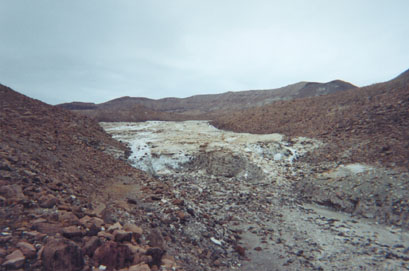
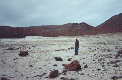
Okay, next... the onyx springs overlooking Gonzaga... This is like a giant glacier... of mineralized water oozing out of the ground...
The edge of the glacier...
Looking west:
Looking east:
Exact directions not posted by request of a Baja Nomad (you can see this from the beach, by the way).
|
|
|
David K
Honored Nomad
Posts: 65509
Registered: 8-30-2002
Location: San Diego County
Member Is Offline
Mood: Have Baja Fever
|
|
The El Camino Real trail to Mision Santa Maria...

Begins at: N29°41.733' W114°28.175' (NAD27) on the north bank of the Santa Maria riverbed, just east of the canyon entrance...

|
|
|
David K
Honored Nomad
Posts: 65509
Registered: 8-30-2002
Location: San Diego County
Member Is Offline
Mood: Have Baja Fever
|
|
Molino de Lacy from Space
MOLINO DE LACY
|
|
|
David K
Honored Nomad
Posts: 65509
Registered: 8-30-2002
Location: San Diego County
Member Is Offline
Mood: Have Baja Fever
|
|
MISSION-ERA WAREHOUSE from Space
MISSION-ERA WAREHOUSE
|
|
|
David K
Honored Nomad
Posts: 65509
Registered: 8-30-2002
Location: San Diego County
Member Is Offline
Mood: Have Baja Fever
|
|
ONYX SPRINGS from space
ONYX SPRINGS
|
|
|
David K
Honored Nomad
Posts: 65509
Registered: 8-30-2002
Location: San Diego County
Member Is Offline
Mood: Have Baja Fever
|
|
Start of El Camino Real hike, from space
Unfortuately, just outside of the high resolution image area!
El Camino Real to Mision Santa Maria start
|
|
|
David K
Honored Nomad
Posts: 65509
Registered: 8-30-2002
Location: San Diego County
Member Is Offline
Mood: Have Baja Fever
|
|
LA TURQUESA CANYON from Space
GREEN POOLS in La Turquesa Canyon
|
|
|
cpg
Nomad
Posts: 262
Registered: 4-10-2006
Location: Livermore, Ca.
Member Is Offline
|
|
Hi David
Do you know if there is a way to drive to bahia de remedios?
Thanks
|
|
|
David K
Honored Nomad
Posts: 65509
Registered: 8-30-2002
Location: San Diego County
Member Is Offline
Mood: Have Baja Fever
|
|
YES... That's easy... I even have the road GPS'd in my web site's GPS page...
It goes north of the dry lake, through a cool pass to Arroyo Mesa de Yubay... then turn right (left goes to the next lake and Candeleros beach)
through another cool canyon to Remedios/ Guadalupe Bay.
|
|
|
David K
Honored Nomad
Posts: 65509
Registered: 8-30-2002
Location: San Diego County
Member Is Offline
Mood: Have Baja Fever
|
|
It would be fun to return to these places and see them after 10 years!
|
|
|
basautter
Senior Nomad
Posts: 862
Registered: 7-1-2013
Member Is Offline
|
|
I think the new interest has something to do with the pavement...
|
|
|
TMW
Select Nomad
Posts: 10659
Registered: 9-1-2003
Location: Bakersfield, CA
Member Is Offline
|
|
David have you been to the white areas below the large onyx springs? It looks like the first one below is also an onyx spring.
|
|
|
David K
Honored Nomad
Posts: 65509
Registered: 8-30-2002
Location: San Diego County
Member Is Offline
Mood: Have Baja Fever
|
|
Only walked to the big one, did not see over the hill to the smaller one... Looking over Baja closely from space, there are so many interesting things
I would like to see! When Chris and I went there, we didn't know about Google Earth (was it even invented yet?).
This was the reason for my interest!:
http://dezertmagazine.com/mine/1959DM01/index.html
On Page 9
|
|
|
bajatrailrider
Ultra Nomad
Posts: 2544
Registered: 1-24-2015
Location: Mexico
Member Is Offline
Mood: Happy
|
|
David where you in canyon green pools/copper mine.Same canyon that goes up to Fred's tractor trail,to high way 1.Then north to Cativina.? Love the
pictures,good write up.
|
|
|
David K
Honored Nomad
Posts: 65509
Registered: 8-30-2002
Location: San Diego County
Member Is Offline
Mood: Have Baja Fever
|
|
Quote: Originally posted by bajatrailrider  | | David where you in canyon green pools/copper mine.Same canyon that goes up to Fred's tractor trail,to high way 1.Then north to Cativina.? Love the
pictures,good write up. |
Yes, but it is a turquoise mine... La Turquesa Canyon. Didn't see any other mine holes or pits when I first went there in 1975.
Roy (The Squarecircle) with help from Tom and friends, (TW or TMW now, here) made it across the canyon going west from the mine and then climbed up
the La Turquesa Grade (Fred Hampe's Tractor Trail).
|
|
|


