edm1
Senior Nomad

Posts: 568
Registered: 8-23-2006
Location: Oak Hills, Ca
Member Is Offline
|
|
Soledad beach to Erendira
Is there a trail/road along the shore that goes from Soledad to Erendira?
How about Erendira to Punta Baja, again along the shore?
Thanks in advance.
Art
|
|
|
DanO
Super Nomad
Posts: 1923
Registered: 8-26-2003
Location: Not far from the Pacific
Member Is Offline
|
|
| Quote: | Originally posted by edm1
Is there a trail/road along the shore that goes from Soledad to Erendira?
|
There is no open coastal route all the way from Soledad/Puerto Santo Tomas to Erendira as far as I know. The road south from the Punta China fork off
of the La Bocana road ends, for the public anyway, at the gates of the Punta China quarry. That leaves two ways to get to Erendira from the north:
1. The road that runs out the back of Santo Tomas to Punta Cabras and points south, which is the route for the Baja 500 this year (link here: http://forums.bajanomad.com/viewthread.php?tid=45768)
2. The road that cuts south from the La Bocana/Punta China road roughly four miles inland from La Bocana. This road, which does not show up on the
race map, was in poor condition in a few spots when I rode it on the dirt bike last summer, but overall it was a fun ride. That was before this
winter's heavy rains, so I have no clue what it looks like now. It goes through a number of ranchos and there are roads criss-crossing in various
spots, so wrong turns are possible. You can trace a route out on Google maps that will dump you out on the coast just north of the lighthouse at
Punta San Jose.
I'd be interested to hear a report if you go that way. That ride from La Bocana down to Punta San Jose then looping back north to Santo Tomas and
then out again to La Bocana -- with a stop for lunch and a cold one at El Palomar -- is a great way to waste a few hours. Next time I may stop at the
winery instead for a wine tasting.
\"Without deviation from the norm, progress is not possible.\" -- Frank Zappa
|
|
|
David K
Honored Nomad
Posts: 65563
Registered: 8-30-2002
Location: San Diego County
Member Is Offline
Mood: Have Baja Fever
|
|
Art, pick up a copy of the Baja Almanac... depite some errors, it is the best maps of Baja you can have... Available from DiscoverBaja.com if not the
publisher directly...
|
|
|
edm1
Senior Nomad
Posts: 568
Registered: 8-23-2006
Location: Oak Hills, Ca
Member Is Offline
|
|
Thanks DanO, that is so helpful. Hmmm, I din't know I could find myself pre-running the Baja500 :-)
|
|
|
edm1
Senior Nomad
Posts: 568
Registered: 8-23-2006
Location: Oak Hills, Ca
Member Is Offline
|
|
David, I'll check with DiscoverBaja if I can buy something that can be downloaded; just not sure if it will arrive before I leave for baja. This
LBMaps/GPS I have doesn't have enough details. I plan to leave on Tue, spend a few days exploring the Pacific side, and be at Rancho Sta Ines before
dark Friday, spending the night there to meet you guys Sat am.
[Edited on 5-19-2010 by edm1]
|
|
|
David K
Honored Nomad
Posts: 65563
Registered: 8-30-2002
Location: San Diego County
Member Is Offline
Mood: Have Baja Fever
|
|
| Quote: | Originally posted by edm1
David, I'll check with DiscoverBaja if I can buy something that can be downloaded; just not sure if it will arrive before I leave for baja. This
LBMaps/GPS I have doesn't have enough details. I plan to leave on Tue, spend a few days exploring the Pacific side, and be at Rancho Sta Ines before
dark Friday, spending the night there to meet you guys Sat am.
[Edited on 5-19-2010 by edm1] |
Here is a close up showing the Soledad to Erendira coastline from the out-of-print 2003 Baja Almanac... the gap is because that map is split on two
pages...
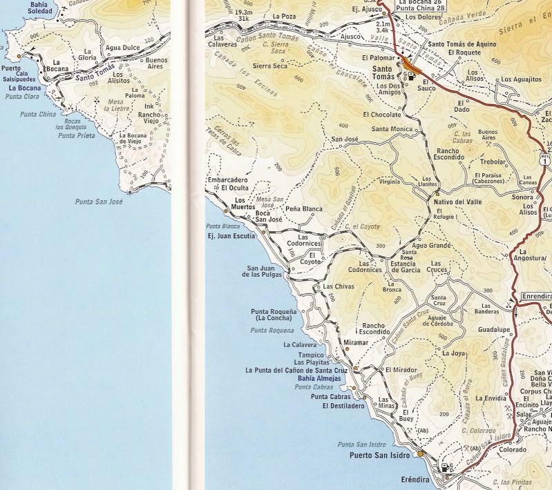
I don't see any additions on the new edition, it is less detailed because the scale is smaller... maps are bigger.
|
|
|
DanO
Super Nomad
Posts: 1923
Registered: 8-26-2003
Location: Not far from the Pacific
Member Is Offline
|
|
Yeah, the road I'm talking about is the one just to the left of the page fold, which takes a right turn about half way and hits the coast at La Bocana
de Viejo. Going straight instead and coming out just south of Punta San Jose is slightly less gnarly.
\"Without deviation from the norm, progress is not possible.\" -- Frank Zappa
|
|
|
BajaWarrior
Super Nomad
Posts: 2307
Registered: 9-27-2006
Location: Mission Bay, San Diego. Playa Hermosa, San Felipe.
Member Is Offline
Mood: Anxious to get south
|
|
| Quote: | Originally posted by DanO
Yeah, the road I'm talking about is the one just to the left of the page fold, which takes a right turn about half way and hits the coast at La Bocana
de Viejo. Going straight instead and coming out just south of Punta San Jose is slightly less gnarly. |
DanO,
We took that road too from La Bocana with our quads on Easter Sunday but but split left at Rancho Viejo and ended up just on the south side of Punta
San Jose. We rode as far as Punta Roquena that day before turning around.
Punta San Jose.

From Erindira we've ridden to the shipwreck south of Quatros Casas on Punta San Jicento and also from Erindira north to the south locked gates of the
Quarry at Punta China.
edm1, come in at Santo Tomas and take it to the coast and head south. Spectacular coastline, but you'll be going inland 8 miles south of Erindira up a
well worn hill connecting to a road south leading you to San Antonio del Mar and beyond.
I've done this trek recently so contact me if you need more information but you'll be able to pick up the Baja 500 trail easily enough.
Haven't had a bad trip yet....
|
|
|
edm1
Senior Nomad
Posts: 568
Registered: 8-23-2006
Location: Oak Hills, Ca
Member Is Offline
|
|
Thank you all. Got all the routes compiled for my Pacific Coast run. I'm adding El Marmol, El Volcan to my itinerary, before hitting Sta Ines next
Saturday.
|
|
|
David K
Honored Nomad
Posts: 65563
Registered: 8-30-2002
Location: San Diego County
Member Is Offline
Mood: Have Baja Fever
|
|
I hope you get photos of El Volcan erupting!!! (happens once a month)
|
|
|
bigzaggin
Nomad
Posts: 441
Registered: 5-27-2004
Member Is Offline
Mood: way too ites
|
|
Also done that road from just inland of Bocana over to Punta San Jose a few times. A few notes if memory serves: there is sometimes a gated entry to
the rancho as you crest the first big hill. I have opened/driven through a number of a times (and closed) and the farmers don't care (stop and have a
beer with those guys if you see them...very nice family).
Regarding the fork - if you head to the LEFT you will come out above and to the S of San Jose (essentially above Victor's place), but the road to the
right that skirts the coast - and leads to the very tip of the point at San Jose (beyond the fishcamp) - is way more fun. But be warned - there
is/was a stretch just before you get there where the road sometimes partially washes out and gets VERY narrow. I have had to turn back before and I
drive a Tundra. Judging by your avatar, you've got something slightly wider.
|
|
|