El Jefe
Super Nomad

Posts: 1027
Registered: 10-27-2003
Location: South East Cape
Member Is Offline
|
|
East Cape. Where, what?
There is another thread about road conditions with the following from me, but the idea of the east cape has always been interesting to me. Exactly
what does the region include? Here is what i posted;
"Depends on what you mean by East Cape. Many folks refer to Los Barriles and La Ribera as East Cape. But to me, those places are towns on the east
side of baja. Nice places too. But I see the East Cape as a region that starts east of Pueblo la Playita (AKA Puerto los Cabos) and extends NE up the
dirt coast road to Cabo Pulmo. There are small settlements and ranchos along the way, but no towns, hence the need for a name to call the area that is
such a nice destination. East Cape."
If you live in Los Barriles, do you say I live in the east cape? If so, why not just say you live in Los Barriles? It is on the map in a big way. And
it"s clear around the big corner from the cape. Not trying to be sarcastic here. Just curious. I wonder how the term originated. The road past my
place near La Fortuna rancho used to have a plaque on it from the 80's that called the road Camino Cabo del Este. But anyhow, when I tell people I
live on the east cape (should it be capitalized?) they often say, "Oh Los Barriles?" So now I've gone to telling them I live on the near-east cape, or
the south-east cape. That really gets them thinking.
So, I know the term has been used since at least the 70's and probably well before that. Any clues, opinions?
No b-tchin\' in the Baja.
|
|
|
El Jefe
Super Nomad
Posts: 1027
Registered: 10-27-2003
Location: South East Cape
Member Is Offline
|
|
I like the way you think.
No b-tchin\' in the Baja.
|
|
|
David K
Honored Nomad
Posts: 65509
Registered: 8-30-2002
Location: San Diego County
Member Is Offline
Mood: Have Baja Fever
|
|
Hi Tom, I just flipped through my copy of The Unforgettable Sea of Cortez (by Gene Kira)... hoping to find a first reference to the term 'East
Cape'...
East Cape did appear on Ray Cannon's 1966 map... and while I will continue to search, what I came up with so far was East Cape was used to describe
the area of Rancho Buena Vista (which converted from a goat ranch to a fishing resort in 1952). The auto road in those days only briefly skirted the
coast (as does Hwy. 1 today), so Cabo Pulmo to San José del Cabo saw no traffic and thus wasn't a destination to have a special name.
Ray Cannon liked to give names to parts of Baja: Midriff, Juanaloa, East Cape all appear with the same font on his map and we do know that Ray made up
the names Midriff and Juanaloa.
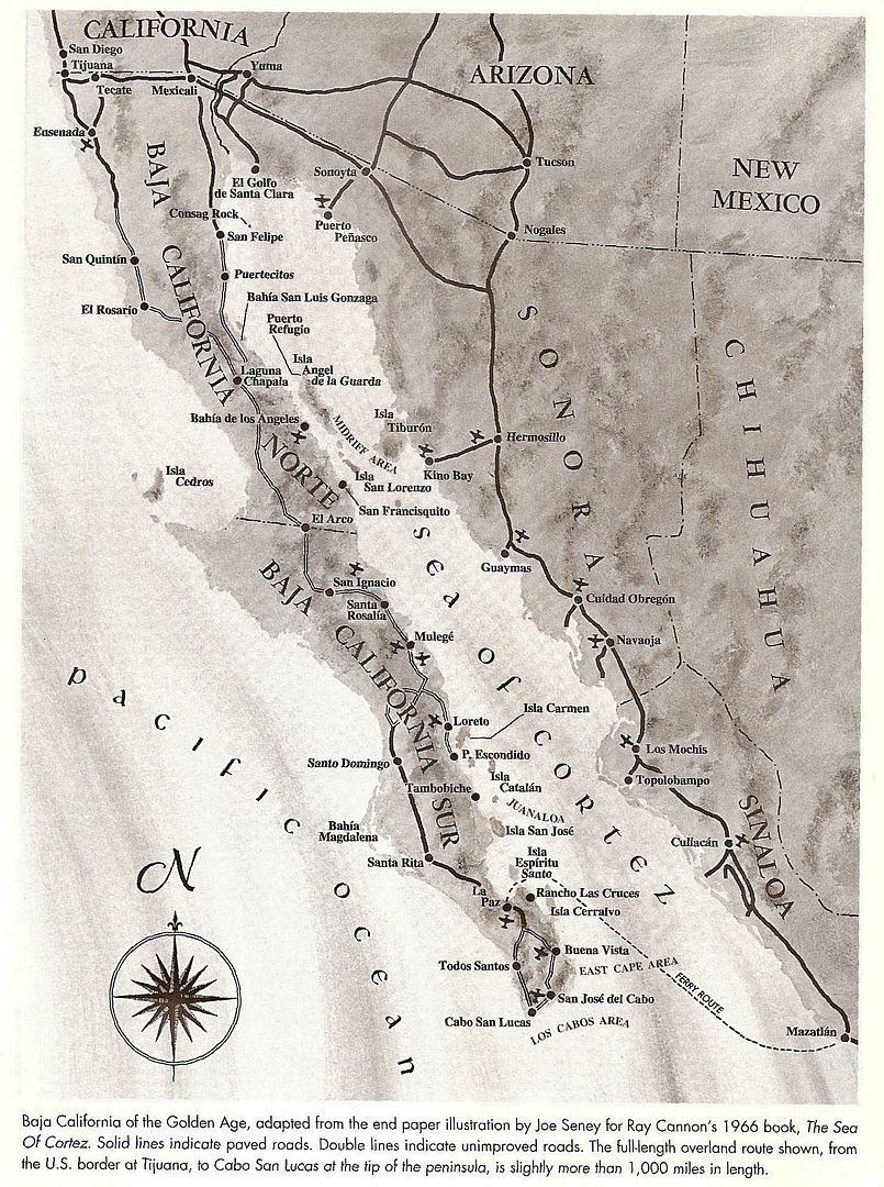
1962 Gulick Map (pavement ended just a few miles south of La Paz). In 1966, pavement ended about 10 miles from La Paz and new road grading had reached
just past San Bartolo... beyond there it was just a single lane 'Jeep' road past Los Barriles to Cabo San Lucas, then back north to Todos Santo where
a wide graded road began and returned you to La Paz.
|
|
|
El Jefe
Super Nomad
Posts: 1027
Registered: 10-27-2003
Location: South East Cape
Member Is Offline
|
|
Ah, so the Buena Vista area near Los Barriles was referred to as the East Cape in the 50's. Thanks David. Figured you might come up with something.
No use fighting it. Guess I'll have to continue calling my environs the south-east cape. Or maybe just "out the dirt road a piece."
No b-tchin\' in the Baja.
|
|
|
David K
Honored Nomad
Posts: 65509
Registered: 8-30-2002
Location: San Diego County
Member Is Offline
Mood: Have Baja Fever
|
|
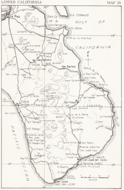
Ray Cannon 1966 Sea of Cortez book map
Zoom in...
Note: Midriff Area, Juanaloa, East Cape Area on map (Ray's terms for these three hot fishing regions).
|
|
|
David K
Honored Nomad
Posts: 65509
Registered: 8-30-2002
Location: San Diego County
Member Is Offline
Mood: Have Baja Fever
|
|
Tom, East Cape is clearly posted in front of your home... I think you are safe using that name!
Oh, and like all maps, this one does have an error... the pavement north from La Paz ended near Santa Rita in 1966... but a road bed was made for
pavement all the way to just north of Santo Domingo... it just didn't happen then.
|
|
|
windgrrl
Super Nomad
Posts: 1336
Registered: 9-2-2006
Member Is Offline
|
|
Interesting. The first cab company we used from CSL to LB years ago had "T.T. Cabo del Este, BCS" written and operates out of LB. I thought the named
referred to this area in general. Or maybe it was named that way as it serves the fishing hotels from Playa del Sol to Punta Colorada?
When the way comes to an end, then change. Having changed, you pass through.
~ I-Ching
|
|
|
tiotomasbcs
Super Nomad
Posts: 1837
Registered: 7-30-2007
Location: El Pescadero
Member Is Offline
|
|
Over here on the Pacific we like to call the area the West Cape just to match the Sea of Cortez area. We even have a little surf, SoulMan. Gettin
ready for La Pascua, Spring Break, over there Jefe? Thank our Lucky Stars the road has never been paved! I've enjoyed the area since the eighties
and it's much the same.  Tio Tio
|
|
|
El Jefe
Super Nomad
Posts: 1027
Registered: 10-27-2003
Location: South East Cape
Member Is Offline
|
|
Hey Tio, I like West Cape! Hah. No kidding about the road. I hate it when I drive to town, and I love it after I'm home. Muy tranquilo aqui. Already
have had a taste of early season south swells. All is good with the world.
But this BIG south wind we are having today will bring some of your cold water around the corner. That, and the bougainvillea are blowing all over the
place! Little piles are everywhere. The crosses we must bear.
No b-tchin\' in the Baja.
|
|
|
Justbozo
Nomad
Posts: 139
Registered: 11-20-2012
Location: Lake Michigan/Bahia Concepcion
Member Is Offline
Mood: Got my little stone hut on the bay
|
|
El Jefe
"The crosses we must bear".
OH,SI!
|
|
|
captkw
Ultra Nomad
Posts: 3850
Registered: 10-19-2010
Location: el charro b.c.s.
Member Is Offline
Mood: new dog/missing the old 1
|
|
East Cape
Hola,,as one of the first gringos to start on the east cape..I would say Zac's to Pulmo...but I started at a very young age and don't know a damn
thing>>>>El Jefe..Doug Green ring"s a bell ???... or a guy named "Cactus"??? I'm Proud to be some of the first out There !!!....Baja 's
best !!!................. ..or "richardos " for the chile 's.... ..or "richardos " for the chile 's....
[Edited on 3-10-2014 by captkw]
[Edited on 3-10-2014 by captkw]
|
|
|
David K
Honored Nomad
Posts: 65509
Registered: 8-30-2002
Location: San Diego County
Member Is Offline
Mood: Have Baja Fever
|
|
I always thought of a cape being like a point, only not as 'pointy'... roundish.
A good example of a Baja cape besides San Lucas is Cabo San Lazaro (Isla Magdalena), Cabo San Quintin, and Cabo Colonet (although it seems to be
called Punta Colonet more now).
|
|
|
BajaNomad
Super Administrator
Posts: 5020
Registered: 8-1-2002
Location: San Diego, CA
Member Is Offline
Mood: INTP-A
|
|
| Quote: | Originally posted by El Jefe
I see the East Cape as a region that starts east of Pueblo la Playita (AKA Puerto los Cabos) and extends NE up the dirt coast road to Cabo Pulmo...
...The road past my place near La Fortuna rancho used to have a plaque on it from the 80's that called the road Camino Cabo del Este.
|
Are you referencing the plaque noting the road from La Ribera to La Playita as "El Camino Rural Costal" (The Rural Coastal Road)?
Google Maps notes that road now as the "Camino Cabo Este".
When I was young, I admired clever people. Now that I am old, I admire kind people.
â Rabbi Abraham Joshua Heschel
We know we must go back if we live, and we don`t know why.
â John Steinbeck, Log from the Sea of Cortez
https://www.regionalinternet.com
Affordable Domain Name Registration/Management & cPanel Web Hosting - since 1999 |
|
|
El Jefe
Super Nomad
Posts: 1027
Registered: 10-27-2003
Location: South East Cape
Member Is Offline
|
|
Yes, I think you may be right. The plaque was torn off the monument a few years ago so I can't go over and check. Maybe I was thinking of the Google
notation.
That plaque either got melted down or its hanging on somebody's wall as a souvenir.
No b-tchin\' in the Baja.
|
|
|