Mike Kay
Newbie
Posts: 13
Registered: 10-11-2015
Member Is Offline
|
|
Agua Verde south - info?
Looking for any and all info about tracks from Agua Verde south. We are 5 accomplished dirt bikers heading down for a Tecate to Cabo run, want to ride
some new to us stuff.
Baja Almanacs dont show the tracks south out of Agua Verde, but google earth and Bing both seem to show tracks down Santa Gertrudis wash connecting to
the established ranch roads, and possibly tracks to Santa Marta Bahia.
We have GPX from Constitution to Gonzaga to la Soledad (got gas there couple years back) to the Sea of Cortez south to La Paz. So any route north of
this towards Agua Verde would work.
Ive been down to Agua Verde, but turned around and headed back to 1. Wish i had done some scouting.
Anybody been on any of this? GPX tracks would be awesome, but any info at all would be helpful. Gracias!
|
|
|
motoged
Elite Nomad

Posts: 6481
Registered: 7-31-2006
Location: Kamloops, BC
Member Is Offline
Mood: Gettin' Better
|
|
All Baja Nomad posts suggest that the route that used to exist is impassable due to storm damage over past few seasons.
Last people through were 4X4's and needed to do some road building and that was two years ago....
The damaged area is just the section going down to a sand wash connecting to the road between Rancho Cosmo (sp?) to Agua Verde from the road systems
coming out of Ciudad Constitucion.
Use the search function on this forum to get reports from over past 2 years.
I ride and have scoped it out but did not ride "up" from the sand wash you see on GE...
Send pics if you do it.
Don't believe everything you think....
|
|
|
4x4abc
Ultra Nomad
Posts: 4455
Registered: 4-24-2009
Location: La Paz, BCS
Member Is Offline
Mood: happy - always
|
|
go check it out and tell us whether it worked out or not
last time I checked the Agua Verde back door trail was impassable at the top
no single track to Santa Marta
http://baja101.com/Baja-GPS/agua-verde-road.kml
Harald Pietschmann
|
|
|
Mike Kay
Newbie
Posts: 13
Registered: 10-11-2015
Member Is Offline
|
|
Thanks for the responses. Harald your tracks follow the route i found on the Bing map. Nice to have corresponding confirmation. We will try that route
mid. Feb. riding down to Ciudad Constitution for fuel and lunch if all goes well. Will check in with a ride report in a month or so. Gracias!
http://www.gpsvisualizer.com/display/20160118151422-04239-ma...
|
|
|
dtbushpilot
Ultra Nomad
Posts: 3297
Registered: 1-11-2007
Location: Buena Vista BCS
Member Is Offline
Mood: Tranquilo
|
|
We rode down that route March 11 2015, it was really bad but with the help of gravity and each other we were able to get all the bikes and riders to
the bottom. One of the young solid riders in our group tried to ride back up a couple of weeks later just to see if he could, he couldn't. I don't
know if anything had been done to repair the road since then. If you go I suggest you get an early start and have a "plan B".....and take pictures and
post a trip report. Good luck, it will be fun.
[Edited on 1-19-2016 by dtbushpilot]
"Life is tough".....It's even tougher if you're stupid.....
|
|
|
Mike Kay
Newbie
Posts: 13
Registered: 10-11-2015
Member Is Offline
|
|
Thanks for the info dtbushpilot. Can you sketch out your experience a bit more? Did you ride Agua Verde towards Ciudad Constitution? Or vice versa?
Sounds like this route is only possible in one direction? If so...which direction worked for you guys? Sounds like we should bring a long rope or at
least get ready to bulldog some bikes down some exposed downhills. Gracias.
|
|
|
dtbushpilot
Ultra Nomad
Posts: 3297
Registered: 1-11-2007
Location: Buena Vista BCS
Member Is Offline
Mood: Tranquilo
|
|
We went from Constitution to AV. It's all easy except for the switchback climb from the arroyo to the top of the mesa (going the direction you are
planning). We came down it, spent the night at Villa del Palmar south of Loreto. The road is washed away in some places leaving only rocks and
crevasses. We got there late, I ended up getting a flat on the way down, rode it ( carried it, pushed it, drug it etc.) that way to the bottom and
fixed the flat there. There were 6 of us so there was help available but I was whooped by the time we got to the bottom of the hill and it was dark.
It wouldn't have been that bad if it was early in the day but our day started in La Paz and I had had all the fun I could tolerate by then, we finally
made it to the hotel around 9pm.
Not sure where you are leaving from in the morning but if you get an early start you will either make it up or have time to come back down and go to
plan B.
"Life is tough".....It's even tougher if you're stupid.....
|
|
|
4x4abc
Ultra Nomad
Posts: 4455
Registered: 4-24-2009
Location: La Paz, BCS
Member Is Offline
Mood: happy - always
|
|
one of the reasons I love Google Earth so much, is that you can pull so much information from a track that you load.
Like the one I provided a few days ago.
Open the Elevation Profile and you have everything at your fingertips.
Speed, elevation etc
So, the Agua Verde backdoor trail is 102 Kilometers in length. Last time I drove it, it took me 3 hours and 25 minutes.
A gentle, gradual climb from Constitucion and a dramatic drop at the end into Agua Verde.
As the elevation goes up, the speed goes down.
Nothing really challenging on this trail coming from the south - just a slow steep finish.
Coming from the North it's a different story. When graded, you can almost do it in 2WD. When washed out, it's only for a selected few.
And if you have one of those expedition trucks with a container appartment - stay home and watch it on TV.
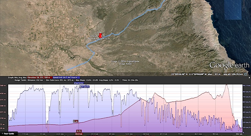
the drops in speed are the turns on the road
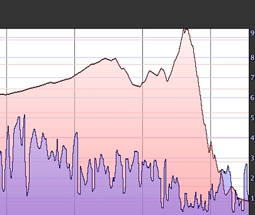
the steep descent into Agua Verde is quite something (a 20% drop)
Harald Pietschmann
|
|
|
captain.olives
Newbie
Posts: 24
Registered: 11-13-2009
Location: NorCal
Member Is Offline
|
|
Mike, when are you folks heading down? If you are the Mike Kay from the old Husqvarna forum, we have some mutual friends (Scott from Sacramento). We
are heading down Friday from the Bay Area with the bikes, though not going that far south this year. Would like to attempt that route next year, so I
will be very curious what your take is.
|
|
|
Mike Kay
Newbie
Posts: 13
Registered: 10-11-2015
Member Is Offline
|
|
dtbushpilot, thanks for the info. sounds like a long day.
4x4abc, gracias. lots of great info again. 20% grade uphill with rocks and ruts. hmmm. you've both got me thinking i need to take this section
seriously. Smaller front sprocket, and some webbing to drag the bikes up...
captain.olives, sorry i didnt see this sooner. have a great trip. do a write up. Say hi to brother Scott for me!
We cross the border Feb 7th. Reach Cabo Feb 15th. SF250 course, Pole Line, Turquesa, Camper Shell, Window Rock, No Wimps, Ignacio to San Juan Pilas to
Mulege, B.Conception to Loreto, AV to CC to LP, LP to Todos to Cabo. Backside of SJ Pilas is gonna be gnarly. Last time we spent the night out
there...
Will share info and some pics when we get back. Thanks again for the info. Viva Baja.
[Edited on 1-30-2016 by Mike Kay]
|
|
|
4x4abc
Ultra Nomad
Posts: 4455
Registered: 4-24-2009
Location: La Paz, BCS
Member Is Offline
Mood: happy - always
|
|
what and where is San Juan Pilas?
Harald Pietschmann
|
|
|
TMW
Select Nomad
Posts: 10659
Registered: 9-1-2003
Location: Bakersfield, CA
Member Is Offline
|
|
It a ranch. Out of San Ignacio toward Laguna then turn south to El Patrocino then south and east to Arroyo San Pedro. The road gets rough after a
rancho in the almanac called San Alfonso. No 4 wheelers past San Juan de las Pilas. Road use to run past ranch to near Mission Guadalupe then to
Mulege. There is a 2-3 mile section from las Pilas going east that's messed up.
Almanac page 14 5C.
[Edited on 1-31-2016 by TMW]
|
|
|
TMW
Select Nomad
Posts: 10659
Registered: 9-1-2003
Location: Bakersfield, CA
Member Is Offline
|
|
I did a trip report from our April 2014 trip that went in there and stayed overnight at the ranch. Friendly couple that spoke Spanish only. He took us
to some cave paintings. Nice place, they farm their own veggies. They have an elaborate water system from a spring. Here is the trip report.
http://forums.bajanomad.com/viewthread.php?tid=73500
|
|
|
Mike Kay
Newbie
Posts: 13
Registered: 10-11-2015
Member Is Offline
|
|
Nice trip report. Loved the pics from San Juan de las Pilas. Jesus and Guadalupe are some of the most amazing humans ive ever met. That ranch is my go
to if the Zombies or Aliens take over. He only leaves the ranch a couple times a year, and its a 9 hour mule ride to the nearest place to buy
anything. In a world of preppers, they are gonna survive! We bring in sugar, smokes, hot sauce, coffee. He wants a new lasso, and some Win 30 06
shells for the lions. She wants some tea. What a great place. We bought a few pounds of goat cheese last time, gave it to the Canadians to serve at
their restaurant in San Ig. My point being, San Juan de las Pilas is a magical place now slowly fading away, while i keep my secret places secret,
this place needs more adventurers to stop in for a visit. Back in the day S.J. de las Pilas was in baja adventure books and a regularly visited stop.
Moto tours, jeep rallyes, etc. all used to run up that canyon, over the hill and into Mulege. But the storms have blown that canyon out, and its now
rarely visited, like 3-5 times a year, if that. There is a little booklet to sign and the moto guys are a who's who of baja off roading. As far as i
know the last thru trip was in 2012 when 4 moto guys from SD area did it. Things are now even more blown out, with a new landslide on the Guadalupe
side. The ride up to 'the crest' has concrete in places and stands up to the storms, but the backside has not been repaired in at least 5 years,
despite the occasional rumor. Thats all i got for ya on SJ de las Pilas. Its one of those little outposts where old baja still survives. Well worth
the time and trouble. Last 3 miles are not easy. Again, cool pics TMW.
|
|
|
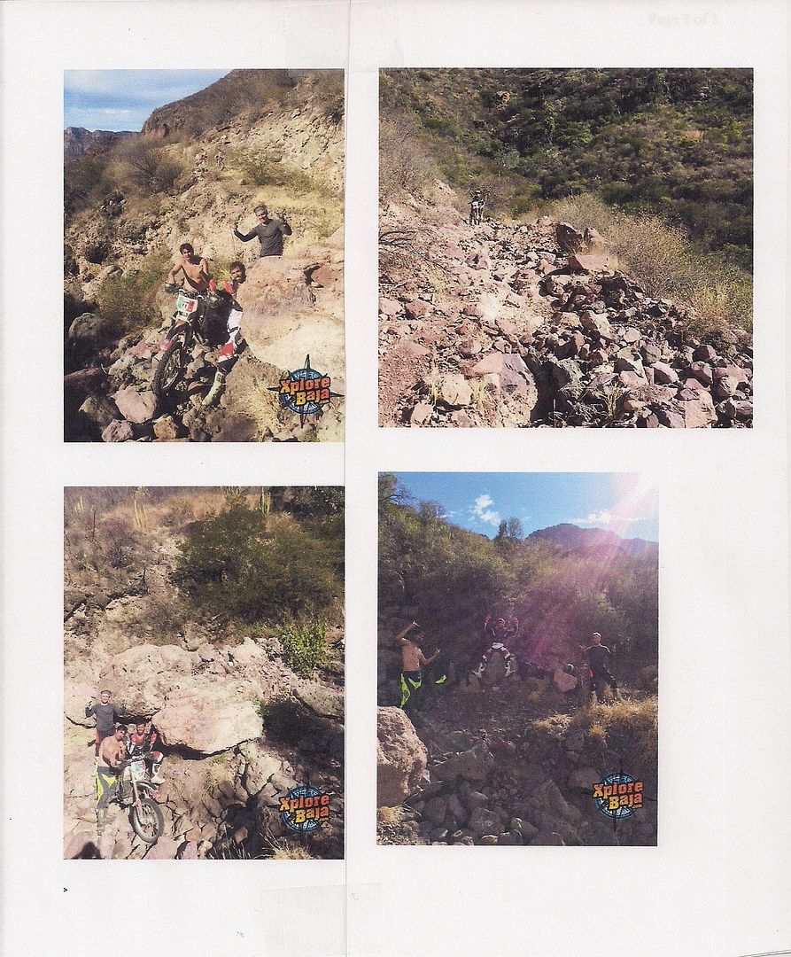
Desertbull
Senior Nomad
Posts: 558
Registered: 8-27-2003
Member Is Offline
|
|
My crew just went thru SJP Mike...I sent Tom our latest photos from a month ago...14 hours to go 120 miles...8 hours on 3 miles and we went DOWN from
Guadelupe at the top to SJP at the bottom...the 4 riders that went down are all Baja moto vets and complete fitness nuts and not one of those guys
thinks going up is even doable after going down... for sure an adventure. Good luck.
DREAM IT! PLAN IT! LIVE IT!
|
|
|
TMW
Select Nomad
Posts: 10659
Registered: 9-1-2003
Location: Bakersfield, CA
Member Is Offline
|
|
Here are the pictures Desertbull sent meof the bad section past San Juan de las Pilas.
|
|
|
TMW
Select Nomad
Posts: 10659
Registered: 9-1-2003
Location: Bakersfield, CA
Member Is Offline
|
|
Mike have you considered doing the bypass loop around las Pilas. I have not been on that road or trail but am interested to know if it is a thru route
especially for a 4x4. The Google Earth image of the route is here, go down a little. It starts out of El Patrocino.
http://forums.bajanomad.com/viewthread.php?tid=81296
|
|
|


