| Pages:
1
2 |
StuckSucks
Super Nomad

Posts: 2376
Registered: 10-17-2013
Location: Pacific Plate
Member Is Offline
|
|
All dams ultimately fill up with debris and become a waterfall - is that what happened here?
|
|
|
AKgringo
Elite Nomad
Posts: 6368
Registered: 9-20-2014
Location: Anchorage, AK (no mas!)
Member Is Offline
Mood: Retireded
|
|
I don't know why the jar of cash was left there, but the pen was obviously left in it just in case you need to write an I.O.U. if you make a
withdrawal!
If you are not living on the edge, you are taking up too much space!
"Could do better if he tried!" Report card comments from most of my grade school teachers. Sadly, still true!
|
|
|
larryC
Super Nomad
Posts: 1499
Registered: 8-11-2008
Location: BoLA
Member Is Offline
|
|
Quote: Originally posted by Fatboy  | | Quote: Originally posted by larryC | Looks like you did some wandering around LA Bay. The rock walls near Animas are not really a mystery, just some left over remnants of habitation in
the area. The rock dam was built in the 1960's by a rancher that thought he could catch some water for his animals. If you look close you will find a
steel pipe near the bottom of the rocks with a brass valve on it. Definitely post Jesuit. The jar with money looks like a geocache, probably near the
Daggett grave out at Las Flores. The rock on a stick (actually a steel rod) is out near Yubai and Herman hill told me that he did that to try to
process some gold ore. No way to verify that claim. No idea who is buried in the grave near the road north of the Animas turnoff. The rabbit just
always looks tired, if you had his love life you'd be tired to.
Not nearly as much mystery out there if you just stop and ask the locals. Fun place to explore though. |
Yep.... The dam and corrals I figured was the 1960/70's - so I was close there. Amazing the amount of work that went into it...4 dams!
The jar was at El Desengano.
Rock on the spit...hmmm gold ore? Not saying it ain't so but doesn't make sense to me....It is set in soft granite, no obvious evidence it was used in
that manner (no tailings, no scarring). Could only process a very small amount if it was so. Would have been much easier to break it up with a hammer.
Just my thoughts, I have only been able to pull a little under 3 ounces of gold out mother earth when I play around with it.
|
As I said that statement about the gold ore was attributed to Herman Hill, and if you knew Herman, you knew to take everything he said with a grain of
salt, much like the book he wrote. But the grinding stone is supported by a steel rod not a wooden stick that the indians would use if it was designed
to grind some grains or what ever. Maybe the steel rod is a recent addition. I have found other "caves" in the area that were obvious habitation sites
that still had the Manos in their mattates. Intersting area around Yubai. Some rock art as you showed and if you look on the ground along the trails
you will find sea shell remnants.
Off grid, 12-190 watt evergreen solar panels on solar trackers, 2-3648 stacked Outback inverters, 610ah LiFePo4 48v battery bank, FM 60 and MX60
Outback charge controllers, X-240 Outback transformer for 240v from inverters, 6500 watt Kubota diesel generator.
|
|
|
willardguy
Elite Nomad
Posts: 6451
Registered: 9-19-2009
Member Is Offline
|
|
that rabbits not tired he's obviously stoned!
here's what our DEA is worried about in utah! 
https://www.washingtonpost.com/news/wonk/wp/2015/03/02/dea-w...
|
|
|
Fatboy
Senior Nomad
Posts: 805
Registered: 6-28-2005
Member Is Offline
|
|
| Quote: Originally posted by AKgringo | | I don't know why the jar of cash was left there, but the pen was obviously left in it just in case you need to write an I.O.U. if you make a
withdrawal! |
Dang! As usual i did it backwards and made a deposit and not a withdrawal!
|
|
|
Fatboy
Senior Nomad
Posts: 805
Registered: 6-28-2005
Member Is Offline
|
|
| Quote: Originally posted by larryC | | Quote: Originally posted by Fatboy | | Quote: Originally posted by larryC | Looks like you did some wandering around LA Bay. The rock walls near Animas are not really a mystery, just some left over remnants of habitation in
the area. The rock dam was built in the 1960's by a rancher that thought he could catch some water for his animals. If you look close you will find a
steel pipe near the bottom of the rocks with a brass valve on it. Definitely post Jesuit. The jar with money looks like a geocache, probably near the
Daggett grave out at Las Flores. The rock on a stick (actually a steel rod) is out near Yubai and Herman hill told me that he did that to try to
process some gold ore. No way to verify that claim. No idea who is buried in the grave near the road north of the Animas turnoff. The rabbit just
always looks tired, if you had his love life you'd be tired to.
Not nearly as much mystery out there if you just stop and ask the locals. Fun place to explore though. |
Yep.... The dam and corrals I figured was the 1960/70's - so I was close there. Amazing the amount of work that went into it...4 dams!
The jar was at El Desengano.
Rock on the spit...hmmm gold ore? Not saying it ain't so but doesn't make sense to me....It is set in soft granite, no obvious evidence it was used in
that manner (no tailings, no scarring). Could only process a very small amount if it was so. Would have been much easier to break it up with a hammer.
Just my thoughts, I have only been able to pull a little under 3 ounces of gold out mother earth when I play around with it.
|
As I said that statement about the gold ore was attributed to Herman Hill, and if you knew Herman, you knew to take everything he said with a grain of
salt, much like the book he wrote. But the grinding stone is supported by a steel rod not a wooden stick that the indians would use if it was designed
to grind some grains or what ever. Maybe the steel rod is a recent addition. I have found other "caves" in the area that were obvious habitation sites
that still had the Manos in their mattates. Intersting area around Yubai. Some rock art as you showed and if you look on the ground along the trails
you will find sea shell remnants. |
I did see the seashell and they did stand out for me.
The area really does have some interesting points it was a shame I only spent a half a day there walking up the wash a little over 2 miles.
|
|
|
larryC
Super Nomad
Posts: 1499
Registered: 8-11-2008
Location: BoLA
Member Is Offline
|
|
That Tinaja has been a watering place since long before the Jesuits started building their missions. Did you make it up as far as the little rock
wall? Then right there, on the other side of the wash there is a little overhang with a hole in it and some rock art in there also. Also on the same
side of the wash as the wall is a rock that you can crawl under and escape the heat of the day. there use to be a mano in there which I saw on my
first trip up there but on my next trip up there it was gone. Also more rock art under that rock. Several more habitation sites higher up the hill
above the rock shelter.
Off grid, 12-190 watt evergreen solar panels on solar trackers, 2-3648 stacked Outback inverters, 610ah LiFePo4 48v battery bank, FM 60 and MX60
Outback charge controllers, X-240 Outback transformer for 240v from inverters, 6500 watt Kubota diesel generator.
|
|
|
Fatboy
Senior Nomad
Posts: 805
Registered: 6-28-2005
Member Is Offline
|
|
Seems to, I just wonder was it pretty gradual or a few big storms did it?
Also since there are actually 4 dams there I wonder about the progression, did they build each one after the previous one filled with debris or did
they build them all about the same time then they all filled in about the same time?
|
|
|
Fatboy
Senior Nomad
Posts: 805
Registered: 6-28-2005
Member Is Offline
|
|
| Quote: Originally posted by larryC | | That Tinaja has been a watering place since long before the Jesuits started building their missions. Did you make it up as far as the little rock
wall? Then right there, on the other side of the wash there is a little overhang with a hole in it and some rock art in there also. Also on the same
side of the wash as the wall is a rock that you can crawl under and escape the heat of the day. there use to be a mano in there which I saw on my
first trip up there but on my next trip up there it was gone. Also more rock art under that rock. Several more habitation sites higher up the hill
above the rock shelter. |
Yes, saw the wall. Found one of the sites you mention. Any ideas on the wall? Natives or more recent? I then walked a mile or so further up the wash.
|
|
|
nomana
Junior Nomad
Posts: 42
Registered: 5-1-2016
Location: Punta Banda
Member Is Offline
|
|
Cross on the side of the road is where someone died. It is most likely the site of an auto accident.
|
|
|
bacquito
Super Nomad
Posts: 1615
Registered: 3-6-2007
Member Is Offline
Mood: jubilado
|
|
Thanks, interesting comments and photos.
bacquito
|
|
|
David K
Honored Nomad
Posts: 65587
Registered: 8-30-2002
Location: San Diego County
Member Is Offline
Mood: Have Baja Fever
|
|
Well, it was Choral Pepper who got me interested in finding the site as she nor any of the survivors of the 1966 expedition could recall the exact
location.
Besides Choral, I talked to Bruce Barron (who is the one standing by the ruins in the Desert Magazine photos), J.W. Black, and Ricardo Costillo of
Mulege... None could recall where the wall was other than south of L.A. Bay and after their visit to Bahia las Animas to gather clams (as noted in
Erle Stanley Gardner's 'Off the Beaten Track in Baja' c1967).
Here is the chapter from the unpublished final Baja book by Choral Pepper... revised from her famous 1973 Baja Missions book:
Santa Maria Magdalena-In Search of A Mission Legend:
Because this formerly lost site motivated so many requests for directions following its discovery recounted in my early Baja book, I will describe
details of the route as closely as I can recall. I tried to find it again in 1995, but we ran into a storm that partially washed out the bridge and
much of the road that now loosely follows the old Padres Gulfo Camino, thus making it impossible to establish a camp and re-explore the area.
During the 1966 expedition with Erle Stanley Gardner, one goal was to locate a lost mission trail known as the Padres Gulfo Camino, believed to follow
along the Gulf coast between Bahia de los Angeles and Punta San Francisquito. As Gardners caravan plunged along an abandoned road that once served
the ore mills at Las Flores we speculated, somewhat derisively, upon the ability of a team of drivers for the Automobile Club of Southern California
who reportedly had turned back after about twenty miles. Then we reached the end of that twenty miles! The scene changed.
No longer was there any trail, or even a sign of one. Forests of cardon and spiny Palo Adam set up a cacophony of screeches against our vehicles. Soft
sand spewed and slid under the wheels as we traveled about two miles an hour. And then, like the parting of a sea, it suddenly opened into a broad
sandy wash like a cardon boulevard. Some deserts are hard and rocky, some harsh and black, others brilliant with red and orange. This one was pastel
where gray-blue smoke trees feathered against pink sand and immense cardon reigned in uncrowded splendor. We followed the wash until it grew shallow
and opened into verbena-splashed dunes inshore from the Bahia de Las Animasa perfect spot to set up camp.
The area we named Cardon Boulevard as we retraced the long- abandoned Padres Gulfo Camino.
A variety of rugged vehicles always accompanied Gardner expeditions. My favorite was a sort of dune buggy we called a grasshopper which was
specially manufactured by Gardners friend J.W.Black to accommodate Baja gringos. Once a campsite was established, wed all pile into the fleet of
grasshoppers to explore places the larger vehicles couldnt reach. And that is how we happened upon a site that confounded all of us.
There it was, a primitive dam among rocks and dead trees with a scraggly date palm standing alone. Usually, date palms appear in groves. This one was
relatively young, so must have sprouted from seeds dropped by dead ones.
We left our grasshoppers to climb into the ravine and examine remnants of the dam that once held water in a natural reservoir. An ancient wall
half-buried in sand angled from the dam to stretch in broken sections across the level valley. Then, from the other end, a similar wall serpentined up
the side of a steep mountain. It was easy to miss, as the stones were coated with desert varnish and melded into the rocky terrain. The upper parts of
the wall, constructed above a thicker base typical of mission trails, remained in only a few places. The top of the mountain appeared flat, but its
sides were steep. From where we stood, we could only guess at a structure on top.
It was a hot day and a climb up the hill uninviting, but somehow I felt wed discovered something interesting. Subsequent research proved me right
about that, as established in my earlier Baja books. Today it is generally accepted that this is the old Jesuit mission of Santa Maria Magdalena,
which was never finished, and which had necessitated the Padres Gulfo Camino, later abandoned.
In the first place, the rock-lined wall leading up the steep hill was an enormously ambitious project, much more than Indians native to Baja would
have undertaken on their own. Then, the rocks on the walls were heavily coated with desert varnish, all of it deposited on the upper sides. This black
coating on rocks called desert varnish occurs in desert regions all over the world, often on the faces of rocky cliffs as well as on rock covered
ground. European scientists refer to it as Dunkel Riden and believe it is caused when rainwater soaks into the rock and is then brought back to the
surface by capillary action of the sun. Here it evaporates, leaving a deposit of the chemicals with which it becomes charged according to the
composition of the rock itself. If there is too much moisture, it departs the rock in liquid form and carries the salts with it. If there is too
little moisture, salts are not dissolved to form the varnish on top while unexposed sides remain natural. In desert climates like Baja, it can take
many centuries to form. In less than several hundred years the tops of all these rocks would not have tanned to the same degree. On the plateau at the
top of the mountain, the wall continued around the edge, but in several areas, there were large piles of rock, that appeared to have fallen, or been
knocked down, from a larger structure, possibly a lookout tower.
We were intrigued by a series of rock rings grouped in a colony at the far end of the plateau, some with adjoining openings as if to designate
separate rooms. Early Baja natives connected with the missions often lived in circular pens of stones, sleeping on the bare ground. Eroded clamshells
lay among the rings, suggesting the pens had held people, not cattle.
In view of extensive walls in the now arid valley below and the number of huge old trees, many dead, there must have been a live spring dammed there
at one time. Walls designed to confine cattle as well as the presence of a date palm clearly indicated missionary direction. But, historical as well
as physical evidence re-enforced my identification of the site as Santa Maria Magdalena.
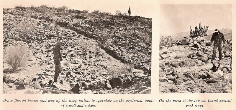
Photos taken in February, 1966 by Choral Pepper and published in her Desert Magazine article that July.
Following a number of Indian insurrections and the destruction of mission properties in 1742, the King of Spain ordered a presidio erected and
instructed the Council of the Indies to propose a plan for the pacification of the whole Baja California territory. As a result, four recommendations
were made, which King Philip V accepted and embodied in a decree dated 1744. These stated that the missionary work of the Jesuits should be continued;
that colonies of Spaniards should be founded near all convenient ports and protected by military posts; that to make quicker conversions among the
natives, missions should be established in the north of the peninsula and united with those of the south; and that the number of missionaries should
be doubled. In return, a complete report and description of missions and mission stations was to be drawn up and sent back to the King.
It was from this report, dated 1745, that we learned Indians had been converted by Friar Fernando Consag and the mission of Santa Maria Magdalena
begun to the north of existing ones. The Venegas map it is identified as Mision de Santa Maria Magdalena, empezada (empezada means begun) at about
latitude 29 degrees and within a few miles of the Gulf. No subsequent reference was ever made of this mission and it was not among those inherited by
the Franciscan Order after the Jesuits had been banished from New Spain by the King, as explained earlier.
Judging from the ruins we examined, it appeared likely the original plans had been aborted and the project never completed. However, the plateau atop
the mountain offered an ideal lookout for a military post and it was located close to two convenient portsthose of Bahia de Los Angeles and Las
Animasin line with the demands of the King. An existing mission trail followed up the center of Baja before crossing to the Pacific Coast, but at the
time Mission Santa Maria Magdalena was instituted, the padres were interested in the Gulf coast, hoping to establish land contact with the missions of
Sonora. No previous Gulf trail then existed. When the mission was abandoned for one reason or another, so was the Gulfo Camino, which we were now
resurrecting.
Author Arthur North wrote in his Camp and Camino in Lower California about a visit in 1904 to ruins of a Jesuit mission chapel named Santa Maria de la
Magdalena about six miles south of Santa Rosalia. However, Peter Gerhard and Howard E. Gulick in their superb Lower California Guidebook referred to
those same ruins as remnants of the Magdalena chapel built by the Dominicans in 1774. They dont refer to them as a mission at all, which makes good
sense considering that the Dominicans didnt even get to Baja until 1773 and their first mission, established in 1774, was much further north on the
Pacific coast. The Jesuits began the Santa Maria de la Magdalena mission on the Gulf as indicated on their 1757 map. Because further reference to the
mission is ignored in other records of importance, I am inclined to believe the ruins south of Santa Rosalia were never a mission, but instead are
those of an early Dominican chapel established to serve rancheros and mines in the productive Magdalena and Santa Rosalia mining area.
In some stretches of this virgin area we noted occasional rows of desert-varnished rocks typical of those outlining known mission roads used by pack
trains to transport supplies and messages from one mission to another. Otherwise, nothing indicated the land had been traversed by more than a coyote.
One bad spot, where we came close to giving up, sliced so sharply down into a deep wash that the men worked for over three hours alternately shoveling
and rebuilding the bank into a grade. To negotiate this kind of country, trucks should be hinged in the middle so they bend.
The Automobile Club of Southern California has long since made it through and its map now indicates a dirt road that extends south from Bahia de Los
Angeles.
===========================================================
|
|
|
pniles
Newbie
Posts: 8
Registered: 6-27-2006
Member Is Offline
|
|
Regarding the Yubay hand arrastra, in "The Hidden Heart of Baja" Erle Stanley Gardner tells of being taken by J. W. Black to a similar hand arrastra
near Bahia de Los Angeles.
Excerpts from the book:
"Thirty -five or forty years ago there was a great deal of mining activity in Baja California. Even today there are many stories of so called
"high-graders" who worked in the mines. [.....] In some of those mines the ore was extremely rich. The vein would be narrow, but would contain what
was called "jewelry rock" - quartz which was flecked with free gold, or little quartz pockets which were lined with pure gold.
According to the legends, these high-graders who were working in the mines would put ordinary ore in the cars to be sent to the mill, but when they
came on a deposit of the so-called jewelry rock, much of it would find its way into the pockets of the miners.
The miners didn't dare sell this rich ore but had to build "molinos de manos" where the ore could be surreptitiously broken up and the free gold
extracted.
The high-graders would therefore have secret molinos so cunningly concealed that they couldn't be found. [....... ] The secret molino, it should be
noted, is a hollow in a rock with a steel rod in the center. On top of this steel rod another big rock is fitted so carefully that seen from even a
few feet away the whole thing looks like a native rock. When the cap rock is lifted off, however, a hollow interior is disclosed in which ore can be
ground up so that the free gold is broken loose from the quartz, can be amalgamated with mercury and recovered.
It was something of a thrill, therefore when J. W. Black suggested that we accompany him to a place where he had found one of these secret molinos.
[.......]"
|
|
|
David K
Honored Nomad
Posts: 65587
Registered: 8-30-2002
Location: San Diego County
Member Is Offline
Mood: Have Baja Fever
|
|
| Quote: Originally posted by pniles | Regarding the Yubay hand arrastra, in "The Hidden Heart of Baja" Erle Stanley Gardner tells of being taken by J. W. Black to a similar hand arrastra
near Bahia de Los Angeles.
Excerpts from the book:
"Thirty -five or forty years ago there was a great deal of mining activity in Baja California. Even today there are many stories of so called
"high-graders" who worked in the mines. [.....] In some of those mines the ore was extremely rich. The vein would be narrow, but would contain what
was called "jewelry rock" - quartz which was flecked with free gold, or little quartz pockets which were lined with pure gold.
According to the legends, these high-graders who were working in the mines would put ordinary ore in the cars to be sent to the mill, but when they
came on a deposit of the so-called jewelry rock, much of it would find its way into the pockets of the miners.
The miners didn't dare sell this rich ore but had to build "molinos de manos" where the ore could be surreptitiously broken up and the free gold
extracted.
The high-graders would therefore have secret molinos so cunningly concealed that they couldn't be found. [....... ] The secret molino, it should be
noted, is a hollow in a rock with a steel rod in the center. On top of this steel rod another big rock is fitted so carefully that seen from even a
few feet away the whole thing looks like a native rock. When the cap rock is lifted off, however, a hollow interior is disclosed in which ore can be
ground up so that the free gold is broken loose from the quartz, can be amalgamated with mercury and recovered.
It was something of a thrill, therefore when J. W. Black suggested that we accompany him to a place where he had found one of these secret molinos.
[.......]"
|
Thank you for sharing this! Time to read E.S. Gardner's books again!
|
|
|
Fatboy
Senior Nomad
Posts: 805
Registered: 6-28-2005
Member Is Offline
|
|
That is cool, PNILES! I need to see if I have that Gardner book and reread, again Thanks!
|
|
|
David K
Honored Nomad
Posts: 65587
Registered: 8-30-2002
Location: San Diego County
Member Is Offline
Mood: Have Baja Fever
|
|
|
|
|
| Pages:
1
2 |
|


