| Pages:
1
2 |
bryanmichaelmeyer
Junior Nomad

Posts: 28
Registered: 11-10-2014
Location: Los Osos, CA
Member Is Offline
|
|
Some great advice here. The baja almanac was the best map i could seem to find (used that is on Amazon for 3 times the original price) without
printing out google map grids. Fortunately this is not possible when i have a month and may be chasing different swells from different angles and
could be all over the place.
|
|
|
David K
Honored Nomad
Posts: 65510
Registered: 8-30-2002
Location: San Diego County
Member Is Online
Mood: Have Baja Fever
|
|
About the 7 Sisters area... maps are not so important because roads do change since they were printed. The Sisters are pretty much north-south (well
actually NW to SE)... and if you want to go to the ocean and can't see it, you take a road going westward. If you want to get to Hwy. 1, go mostly
eastward. Top your gas tank in El Rosario and bring 5-10 extra gallons. That will get you to Villa Jesus María Pemex or one of the vendors at Cataviña
or Parador Punta Prieta, etc. after you have done some exploring.
The AAA map has mileages and that is helpful even if some of the roads are not shown or have changed.
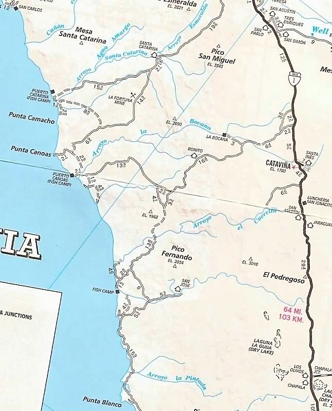
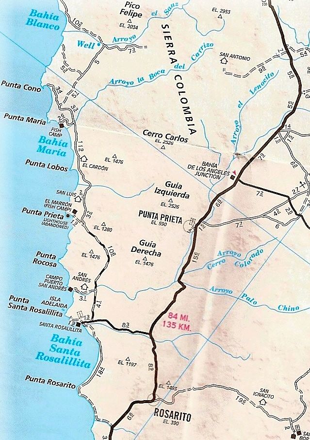
Not shown are the roads from Chapala to just north of Punta Blanco and the road through from Bahía Blanco to Rancho San Antonio and a fork east of San
Antonio that goes to Hwy. 1 about 7 miles north of the Bahía de L.A. jcn. (Parador Punta Prieta).
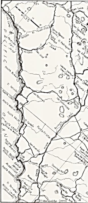
Roads to the Sisters have been on maps for over 50 years... Here is one from the 1962 Lower California Guidebook...
|
|
|
mcnut
Nomad
Posts: 177
Registered: 12-9-2013
Location: Dammeron Valley, UT
Member Is Offline
|
|
For me the GPS is one of several important tools in my navigation toolbox along with a compass, paper maps and a Spot Messenger.
Even if I have fairly good knowledge of where I'm headed, I like to see real time what is around me (side roads, mines etc) and for situational
awareness, direction & distances to whatever (a peak, gas). I am also in the habit of recording and saving the tracks of my outings for future
reference.
For what it is worth I use a Garmin 660 in the car and on the streetbike and a Garmin 78 on foot and offroad motorcycling. Garmin while having some
shortcomings, is far and away the best supported GPS in the western hemisphere.
For Baja maps I load Garmin CityNavigator North America, LB Maps, Garmin TOPO Mexico and some OSM open source maps switching between them on the go as
the need arrises. The E32 maps are likely the best but but the others I have listed serve me well.
Bruce
|
|
|
JZ
Select Nomad
Posts: 14465
Registered: 10-3-2003
Member Is Online
|
|
Quote: Originally posted by bryanmichaelmeyer  | | Quote: Originally posted by PaulW | Chose a GPS for your needs. If you want to make tracks to share. Or do you just want to make waypoints. Or do you just want a pretty map with your
place on the map.
Of course you can share waypoints and tracks with any, but with tracks every GPS uses a different format which means you have to depend on your
computer in order to share with your friends.
Now days you can put Google earth on some GPS's if you like that kind of picture.
A GPS does not come with a background map so are you interested in turn x turn to find your way in the cities like modern autos have with their OEM
navigation system. Or do you just want to find an follow the mostly back country roads. Or are you an race oriented guy like myself and Stuck.
Garmin sells entry level units that have no map capability for a ridiculous low price. I have many Lowrance units and am happy with them all. I have
found good maps for them.
I also have several Garmin's and I have the low end and the high end. The high end has the same maps as my Lowrance. And the low end has nothing. I
use my low end unit daily as part of my fitness program. It gives me speed, time and distance which is all I need (It is an etrex).
Prices - High end Garmin Montana makes track, waypoints and can be loaded with excellent maps. Expect to pay 500-600+ with the accessories not
including the maps.
Prices for the Lowrance high end start at 500 for a typical 7" unit, but come with all you need except maps. Lowrance is difficult because you might
get a marine unit and be very frustrated. They sell land units, but are very hard to find. Example - look at a Trophy 5M Baja which sells for 399. And
buy Murdocknav maps for around 80.
For the average guy I recommend the Montana in spite of the high cost.
If you want something simple that has good map capability, then get a tablet and start accessorizing it. It will still work as a tablet, so its dual
purpose and it is much easier to justify the expense. The main issue will be track sharing due to format differences.
Most important of all, bigger is best. Now days I prefer my 7" Lowrance for very ease of viewing in my rig.
For a newbie choosing a GPS is a pretty daunting task. Just like buying a computer the first time.
Regardless before you buy signup to a forum for the brand you prefer and start reading and asking questions.
BTW, I nave some pretty neat maps on my phone. an I can find my way in a pinch. Iphone or android availability. Hard to live with the small screen.
|
thanks Paul for the help and and positive contributions to my search... You nailed it with the points above as to why I am looking at the Montana
680t. I'll check out the Lawrence land units and sign up for some forums.
Cheers,
Bryan
|
Trust me, it's a big waste of money for a dedicated GPS. The brightness, resolution, and touch screen of your phone is infinitely better than any
GPS.
There is that one guy who has all the dirt roads of Baja available to use as maps. I can dig it up, but if someone has a link they should post it.
If those maps are only available for us on a Garmin that would be the "only" reason I'd go w/a dedicated GPS.
|
|
|
mcnut
Nomad
Posts: 177
Registered: 12-9-2013
Location: Dammeron Valley, UT
Member Is Offline
|
|
| Quote: Originally posted by JZ | Trust me, it's a big waste of money for a dedicated GPS. The brightness, resolution, and touch screen of your phone is infinitely better than any
GPS.
There is that one guy who has all the dirt roads of Baja available to use as maps. I can dig it up, but if someone has a link they should post it.
If those maps are only available for us on a Garmin that would be the "only" reason I'd go w/a dedicated GPS.
|
Trust me, there are compelling arguments for either option. 
Bruce
[Edited on 7-19-2016 by mcnut]
[Edited on 7-19-2016 by mcnut]
|
|
|
RBoffroad
Newbie
Posts: 16
Registered: 10-29-2015
Member Is Offline
|
|
I use Motion X HD. A $3 app on an IPad Mini with a built in GPS. I then downloaded the Google Earth maps for all of Baja into the IPad. Allows you to
see your position as If you were on Google Earth maps and you see all roads in High Def satellite view. You can mark as many waypoints as u like
before u travel. We just did San Felipe to Cabo on ATV's and didn't miss a turn. You can also download others GPX tracks into it. The best $3 I ever
spent.
On another note, the Delorme In Reach paired to the IPad is great for satellite texting and and providing real-time position reports to family and
friends.
|
|
|
JZ
Select Nomad
Posts: 14465
Registered: 10-3-2003
Member Is Online
|
|
| Quote: Originally posted by mcnut | | Quote: Originally posted by JZ | Trust me, it's a big waste of money for a dedicated GPS. The brightness, resolution, and touch screen of your phone is infinitely better than any
GPS.
There is that one guy who has all the dirt roads of Baja available to use as maps. I can dig it up, but if someone has a link they should post it.
If those maps are only available for us on a Garmin that would be the "only" reason I'd go w/a dedicated GPS.
|
Trust me, there are compelling arguments for either option.
Bruce
[Edited on 7-19-2016 by mcnut]
[Edited on 7-19-2016 by mcnut] |
Give me some. It's old school thought that you need a dedicated GPS. Complete waste of $.
I just went from SC (mailand) to La Paz running Navonics on my phone and ipad. $15. Way, way easier to use than a GPS and not another thing to lug
around.
[Edited on 7-20-2016 by JZ]
|
|
|
JZ
Select Nomad
Posts: 14465
Registered: 10-3-2003
Member Is Online
|
|
| Quote: Originally posted by RBoffroad | I use Motion X HD. A $3 app on an IPad Mini with a built in GPS. I then downloaded the Google Earth maps for all of Baja into the IPad. Allows you to
see your position as If you were on Google Earth maps and you see all roads in High Def satellite view. You can mark as many waypoints as u like
before u travel. We just did San Felipe to Cabo on ATV's and didn't miss a turn. You can also download others GPX tracks into it. The best $3 I ever
spent.
On another note, the Delorme In Reach paired to the IPad is great for satellite texting and and providing real-time position reports to family and
friends. |
This is what ppl want to do.
|
|
|
PaulW
Ultra Nomad
Posts: 3113
Registered: 5-21-2013
Member Is Offline
|
|
Of course this thread was about choosing a GPS. Alternate device choices need to start their own thread.
Having said that there is much more that a GPS has to offer than just a pretty picture with your location shown. One reason we use GPS from Garmin
(not Nuvi) and Lowrance because for Baja we have available a peer to peer back road map available. We share then trails/tracks and you will not find
them on your alternate device maps. As an example not one person posted or shared a track for the Pole line road from one of the alternate devices.
Make a track from your alternate device and send me a .USR or .GPX file and you will see what I mean. The many abilities of both brands of GPS way
overshadow what any of the alternate devices can provide.
Its your choice to have a simple an incomplete device. I don't do waypoints just trails/tracks.
|
|
|
willyAirstream
Super Nomad
Posts: 1786
Registered: 1-1-2010
Member Is Offline
|
|
| Quote: |
Same for land, use your phone with an app. Much better, bigger screen than a single purpose GPS. Spend the money to get a good phone like a Samsung
Note 5 or iPhone 6+. Samsung is a good bit better than iPhones fwiw. |
Totally agree. You can share tracks and waypoints, import background maps and much more. However, it needs to be in a dust proof case and be impact
resistance.
For racing a Lowrance can import most formats and use open source maps and holds up to off road racing, it is the standard.
A phone or tablet is perfect for recreational use.
|
|
|
mcnut
Nomad
Posts: 177
Registered: 12-9-2013
Location: Dammeron Valley, UT
Member Is Offline
|
|
| Quote: Originally posted by JZ | | Quote: Originally posted by mcnut |
Trust me, there are compelling arguments for either option.
Bruce
[Edited on 7-19-2016 by mcnut]
[Edited on 7-19-2016 by mcnut] |
Give me some. It's old school thought that you need a dedicated GPS. Complete waste of $.
[Edited on 7-20-2016 by JZ] |
I am well aware that using phone apps can have it's advantages, and the same can be said of dedicated GPS units.
It's pretty clear you have found nirvana with your setup, for that I am happy for you. I have no interest in getting into a peeing match with someone
who because of their experience, thinks others who don't share the same view are somehow misinformed.
Anyone who wishes to dig deeper into the phone vs GPS question need only visit one of the plethora of websites dealing with GPS based navigation. One
free site I often visit and post on is the GPS forum on ADVRider, my username is the same as here.
http://advrider.com/index.php?forums/mapping-navigation.37/
Bruce
[Edited on 7-21-2016 by mcnut]
|
|
|
AKgringo
Elite Nomad
Posts: 6334
Registered: 9-20-2014
Location: Anchorage, AK (no mas!)
Member Is Offline
Mood: Retireded
|
|
With a traditional GPS, you will not be able to download the APP that allows you to run over, I mean capture Pokémon monsters!
That still leave plenty of pot holes, topes and cow pies though.
If you are not living on the edge, you are taking up too much space!
"Could do better if he tried!" Report card comments from most of my grade school teachers. Sadly, still true!
|
|
|
willyAirstream
Super Nomad
Posts: 1786
Registered: 1-1-2010
Member Is Offline
|
|
http://leadnavsystems.com/
|
|
|
| Pages:
1
2 |


