David K
Honored Nomad

Posts: 65509
Registered: 8-30-2002
Location: San Diego County
Member Is Offline
Mood: Have Baja Fever
|
|
Exciting New El Camino Real Website and Google Earth Map
I am happy to share with all of you a new El Camino Real hiking and exploring web-map.
It is the product of many years work and finding the true mission road between Loreto and El Rosario using historical data and actual, on the ground
research.
I was introduced to these folks by Trudi Angell and for the past few months have followed and discussed the web page map with Kevin.
Here is the website: http://caminorealbaja.com/
It is new and may undergo some revisions, just click on the menu items and the map is the section called Waypoints. It opens up in Google Earth and
you may need to spread the timeline pointers apart for the thousands of waypoints to open up. Just zoom in and explore from above!
They have hiked one of the several ECR routes between San Javier and San Ignacio (the primary route) and have hiked the three routes between San
Ignacio and Santa Gertrudis (Pacifico, Sierra, Golfo). From Santa Gertrudis north to San Borja, they have hiked the Sierra and Golfo route, but have a
few key points on the Pacifico route.
North of San Borja, the Jesuits had not had time to build the typical road to Calamajué and Santa María as they were removed from the New World the
following year. The Franciscans and Dominicans who replaced the Jesuits did not have an interest or mandate to construct the roads to the same skill
or degree as had the Jesuits. The ECR north of San Borja to El Rosario resembles little more than a cattle trail (if it can be seen at all) with a few
exceptions.
Here is their story:
We are Genevieve Mattar and Kevin Branscum. We met in South America while she was guiding fellow Canadians to the ruins of the Andes and
the forests of the Amazon. He was an American seeking adventure in the Andes. This was long before we began to explore El Camino Real. Since then, we
have been teamed up, both seeking adventure around the world. We have traveled to many places and have had incredible experiences, but the place that
keeps drawing us back time and again is Baja, Mexico - more specifically, to explore El Camino Real. This is the mission trail that leads from Loreto
in Baja Súr, Mexico to all of the Californias. They include Baja Súr, Baja, and Alta California which is better known as the state of California.
We first became interested in the old mission trail in the year 2000 while visiting the rock art of the Sierra de San Francisco. When we came across a
trail that had a different look from the one we were following, we asked our local guide about it. He replied, “That is the old mission trail, el
camino antiguo de los misioneros”. It headed south up and over a distant pass, and in the other direction followed the valley we were in, traveling
northward.
The mystery of that trail, combined with the history of it and the beauty of its surroundings, had us hooked. For the past 18 years, we have returned
to explore El Camino Real, finding more and more pieces of the trail. Our goal was, and still is, to accurately fix its exact position and then share
it with you. We feel that this is the only way we can help keep this fantastic trail alive.
|
|
|
fishbuck
Banned
Posts: 5318
Registered: 8-31-2006
Member Is Offline
|
|
Wow!
It always amazes me when I see something like this.
I love Baja more than anything else that I know of so far.
But when I see stuff like this it makes me realize that other people love Baja too.
This is obviously a labor of love.
It's quite possible that other people love Baja more than I. And I'm all in.
"A ship in harbor is safe, but that is not what ships are built for." J. A. Shedd.
A clever person solves a problem. A wise person avoids it. – Albert Einstein
"Life's a Beach... and then you Fly!" Fishbuck
|
|
|
TMW
Select Nomad
Posts: 10659
Registered: 9-1-2003
Location: Bakersfield, CA
Member Is Offline
|
|
Wow is right that is a great site.
North of Santa Marta is a trail I've often wondered about that leads to Mission Santa Gertrudis and following their waypoints was great.
Thanks David for posting the site and thanks to Genevieve Mattar and Kevin Branscum for sharing the site.
|
|
|
David K
Honored Nomad
Posts: 65509
Registered: 8-30-2002
Location: San Diego County
Member Is Offline
Mood: Have Baja Fever
|
|
Kevin and I have exchanged a dozen emails today. He said he was ready to go public now... 18 years of hiking and work. He wants to do more including a
Spanish translation plus they will continue to research other Camino Real routes.
I gave him one today that is between Las Arrastras and Las Palmitas that you can see most of on Google Earth, just east of their route between
waypoints I 50 and I 60.
They recently discovered the route north from Calamajué and it was so obvious a choice. However, we had been led to believe it passed through the
mountain and went west of Coco's Corner. I even saw some trail bits northwest of Coco's. Crosby shows it the way they found it, however, staying east
of the mountain, north from Calamajué.
The fun part is there were several ECR routes over the many years, well about 200+ before automobiles.
|
|
|
gueribo
Nomad
Posts: 469
Registered: 10-16-2014
Member Is Offline
|
|
Saw this on Facebook. Look forward to seeing their photos.
|
|
|
David K
Honored Nomad
Posts: 65509
Registered: 8-30-2002
Location: San Diego County
Member Is Offline
Mood: Have Baja Fever
|
|
The photos (other than the ones on the web page) are on the Google Earth maps along the El Camino Real. It is great fun to click on the camera icon
and see their photo at that spot.
They have a photo of Window Rock and comment about the many motorcycle tracks on the mission trail there, wondering if these modern metal mule riders
realize the significance of the route (Bill Nichols) used in this area.
[Edited on 3-26-2018 by David K]
|
|
|
StuckSucks
Super Nomad
Posts: 2375
Registered: 10-17-2013
Location: Pacific Plate
Member Is Offline
|
|
Awesome resource!
|
|
|
David K
Honored Nomad
Posts: 65509
Registered: 8-30-2002
Location: San Diego County
Member Is Offline
Mood: Have Baja Fever
|
|
Please share the link with your fellow Baja history and hiking fans!
|
|
|
David K
Honored Nomad
Posts: 65509
Registered: 8-30-2002
Location: San Diego County
Member Is Offline
Mood: Have Baja Fever
|
|
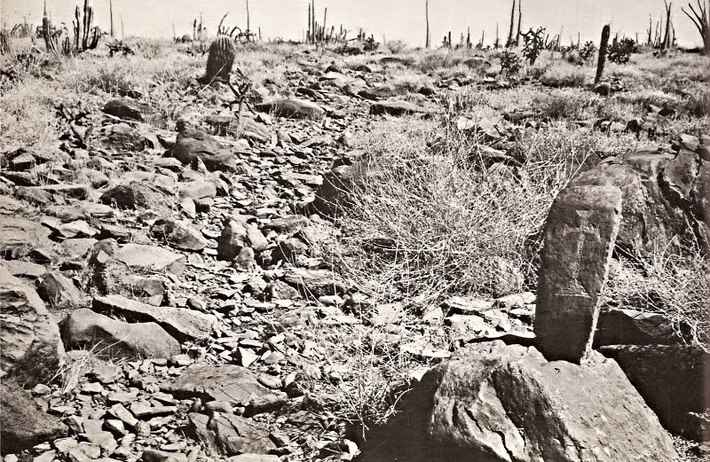
One of the 'highway signs' from the 1760s:
|
|
|
4x4abc
Ultra Nomad
Posts: 4455
Registered: 4-24-2009
Location: La Paz, BCS
Member Is Offline
Mood: happy - always
|
|
does anyone here know why the collection of waypoints initially shows all and then Google Earth reduces their number randomly?
Is it a Google Earth glitch?
It never happened to any of my waypoint collections
Harald Pietschmann
|
|
|
TMW
Select Nomad
Posts: 10659
Registered: 9-1-2003
Location: Bakersfield, CA
Member Is Offline
|
|
I think it is a GE thing. I deleted it on GE and re-openned it from my download file and all the waypoints showed up.
|
|
|
4x4abc
Ultra Nomad
Posts: 4455
Registered: 4-24-2009
Location: La Paz, BCS
Member Is Offline
Mood: happy - always
|
|
I know, reloading restores all points - but that can't be the solution that you have to reload every few minutes
Harald Pietschmann
|
|
|
hermosok123
Nomad
Posts: 102
Registered: 12-11-2016
Member Is Offline
|
|
Once again David comes through with another informational jewel about Baja and its unique places. Thank you
|
|
|
David K
Honored Nomad
Posts: 65509
Registered: 8-30-2002
Location: San Diego County
Member Is Offline
Mood: Have Baja Fever
|
|
My pleasure.
Harald, spread the two timeline pointers apart to see all the points.
|
|
|
TMW
Select Nomad
Posts: 10659
Registered: 9-1-2003
Location: Bakersfield, CA
Member Is Offline
|
|
One would probably have to break the file into smaller sections. It may be too big for GE to handle on a PC.
|
|
|
4x4abc
Ultra Nomad
Posts: 4455
Registered: 4-24-2009
Location: La Paz, BCS
Member Is Offline
Mood: happy - always
|
|
very good - you are becoming an expert
Harald Pietschmann
|
|
|


