| Pages:
1
2
3 |
willardguy
Elite Nomad

Posts: 6451
Registered: 9-19-2009
Member Is Offline
|
|
wow those were adventurous ladies!
hey david, did it break your heart pops didnt go with the FJ45?
[Edited on 9-3-2012 by willardguy]
|
|
|
David K
Honored Nomad
Posts: 65509
Registered: 8-30-2002
Location: San Diego County
Member Is Offline
Mood: Have Baja Fever
|
|
| Quote: | Originally posted by willardguy
wow those were adventurous ladies!
hey david, did it break your heart pops didnt go with the FJ45?
[Edited on 9-3-2012 by willardguy] |
I was 7 1/2 when we first went to Baja. I had no desire for a Toyota until the month I got my first one in 2000.
|
|
|
David K
Honored Nomad
Posts: 65509
Registered: 8-30-2002
Location: San Diego County
Member Is Offline
Mood: Have Baja Fever
|
|
Another photo of the Gonzaga Bay mission warehouse ruin
This one is from the archeologist studying the ruin, Dr. Eric Ritter:

Note Punta Willard/ Papa Fernandez' in the distance.
The image is Fig. 3 in Dr. Ritter's article: http://www.xaguaro.com/MemoriasCD/page2/styled-10/styled-15/
Here again is my photo, three years before Dr. Ritter's:

[Edited on 2-15-2016 by David K]
|
|
|
David K
Honored Nomad
Posts: 65509
Registered: 8-30-2002
Location: San Diego County
Member Is Offline
Mood: Have Baja Fever
|
|
Gonzaga Warehouse in 1958
Photo from Howard Gulick:

|
|
|
4x4abc
Ultra Nomad
Posts: 4455
Registered: 4-24-2009
Location: La Paz, BCS
Member Is Offline
Mood: happy - always
|
|
your maps always stir something up
where is, or which of the known springs is Pozo Salorro?
Harald Pietschmann
|
|
|
freediverbrian
Senior Nomad
Posts: 625
Registered: 2-24-2007
Location: Papas Gonzaga Bay
Member Is Offline
|
|
The spot of the push pin has been a Mexican fish camp for many years , maybe not the most enjoyable hike . wonder what is left?
[Edited on 2-16-2016 by freediverbrian]
|
|
|
willardguy
Elite Nomad
Posts: 6451
Registered: 9-19-2009
Member Is Offline
|
|
not sure why this discussion from 2012 resurfaced, but an easy low tide walk from either direction, there's absolutely nothing to see out there,
decades of both fish and military camps have left the area a bottle cap and fish net collectors paradise. scratch it off DK's list of must things to
do while in Gbay!
|
|
|
David K
Honored Nomad
Posts: 65509
Registered: 8-30-2002
Location: San Diego County
Member Is Offline
Mood: Have Baja Fever
|
|
Why photos are the greatest! I have the photos from Dr.Ritter of the floor in that Gonzaga warehouse. When I come across them, I will share.
So, in 10 years the remains that have been there since 1768 are gone willardguy? It is about 50 feet NW of that concrete slab. Ritter was there not
that long ago.
|
|
|
willardguy
Elite Nomad
Posts: 6451
Registered: 9-19-2009
Member Is Offline
|
|
Quote: Originally posted by David K  | Why photos are the greatest! I have the photos from Dr.Ritter of the floor in that Gonzaga warehouse. When I come across them, I will share.
So, in 10 years the remains that have been there since 1768 are gone willardguy? It is about 50 feet NW of that concrete slab. Ritter was there not
that long ago. |
if you look at the "warehouse floor" at the depth that Dr. Ritter "discovered" and walk east into the bay you'll find exactly the same "flooring"
there as the good doctors dig site revealed. Im still callin' BS.....but I really don't care!
|
|
|
willardguy
Elite Nomad
Posts: 6451
Registered: 9-19-2009
Member Is Offline
|
|
how bout you take a walk out there yourself, and report back?
|
|
|
David K
Honored Nomad
Posts: 65509
Registered: 8-30-2002
Location: San Diego County
Member Is Offline
Mood: Have Baja Fever
|
|
Why the new posts?
A: I found two more photos of the mission warehouse at Gonzaga Bay, so I added them to this thread.
BS?
A: The warehouse existence was published in Aschmann's book (1959) and Gerhard & Gulick's book (2nd edition 1958).
Bah�a San Luis Gonzaga (what some call Willard Bay) was discovered and named by Consag in 1746 and became an important port to offload supplies and
personal during the Franciscan (1768-1773) and Dominican mission periods.
A cargo trail was built from the warehouse to the Camino Real (junction is 4 miles west of Mission Santa Mar�a) as a shorter route to reach Mission
San Fernando and those beyond. Some of the cargo trail is easily seen on Google Earth (between 29�46.965', -114�32.640' and 29�46.165',
-114�34.190').
I just searched and found where I saved Dr. Eric Ritter's photo of the stone floor exposed inside the warehouse at Gonzaga Bay:
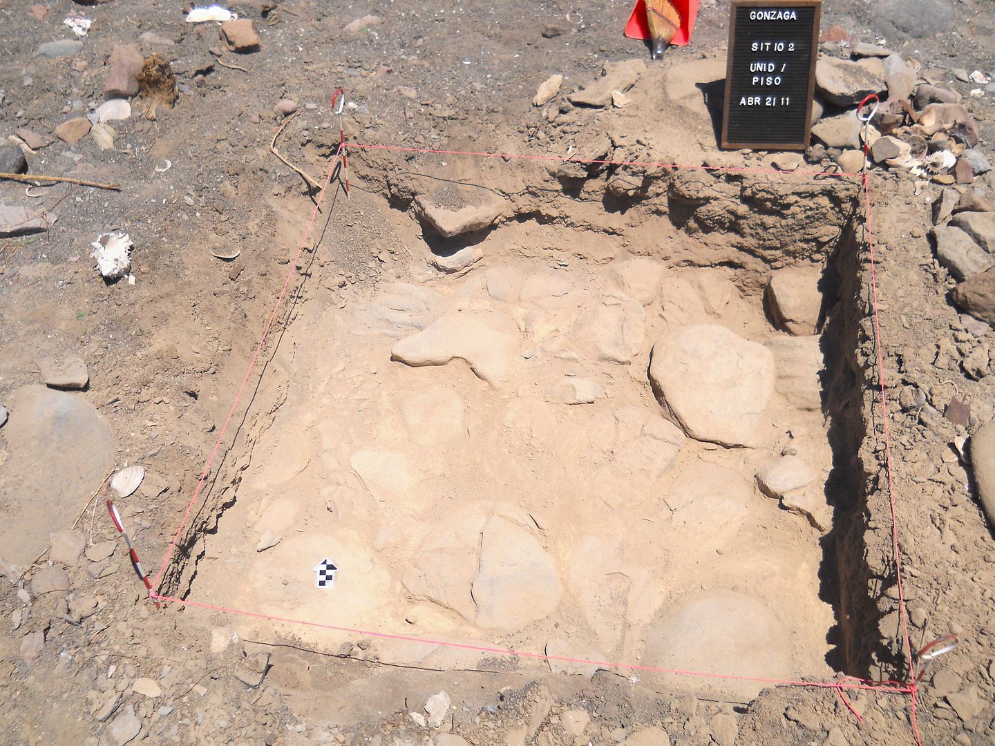
[Edited on 9-7-2023 by David K]
|
|
|
bajatrailrider
Ultra Nomad
Posts: 2544
Registered: 1-24-2015
Location: Mexico
Member Is Offline
Mood: Happy
|
|
Thank you David,love the history.
|
|
|
willardguy
Elite Nomad
Posts: 6451
Registered: 9-19-2009
Member Is Offline
|
|
| Quote: Originally posted by David K | Why the new posts?
A: I found two more photos of the mission warehouse at Gonzaga Bay, so I added them to this thread.
BS?
A: The warehouse existence was published in Aschmann's book (1959) and Gerhard & Gulick's book (2nd edition 1958).
Bahía San Luis Gonzaga (what some call Willard Bay) was discovered and named by Consag in 1746 and became an important port to offload supplies and
personal during the Franciscan (1768-1773) and Dominican mission periods.
A cargo trail was built from the warehouse to the Camino Real (junction is 4 miles west of Mission Santa María) as a shorter route to reach Mission
San Fernando and those beyond. Some of the cargo trail is easily seen on Google Earth (between 29º46.965', -114º32.640' and 29º46.165', -114º34.190').
I just searched and found where I saved Dr. Eric Ritter's photo of the stone floor exposed inside the warehouse at Gonzaga Bay:
|
I have read dr ritters accounts, its all "possibly's, "may be's" "my guess","could be's"his dig really turned up nothing.
that said, im sure it could be mission ruins, the doctor and his colleagues readily admit they just don't know!
I get it that everytime DK spots a pile of rocks its a mission ruin, and an entry in his "missionary's gone wild" series of books, all im saying is
there is absolutely nothing to see out there......today.
|
|
|
David K
Honored Nomad
Posts: 65509
Registered: 8-30-2002
Location: San Diego County
Member Is Offline
Mood: Have Baja Fever
|
|
How about a photo?
I wonder who hauled off all the wall rocks?
Ritter was there less than 5 years ago.
Glad Gulick took lots of photos of the historic sites in the 50's and 60's!
Nov 1958 (Gulick) vs. Nov 2002 (Me) vs. July 2005 (Ritter)
 

|
|
|
4x4abc
Ultra Nomad
Posts: 4455
Registered: 4-24-2009
Location: La Paz, BCS
Member Is Offline
Mood: happy - always
|
|
it's all a conspiracy - the Jesuits were never in Baja
warehouses?
Nahh
Harald Pietschmann
|
|
|
willardguy
Elite Nomad
Posts: 6451
Registered: 9-19-2009
Member Is Offline
|
|
thats a good question david, that pile of rocks was put there by either the jesuits, franciscans, or colonials, doctor tex ritter or his cohorts
don't really know......but some jackwagon came along and stole them for their private collection, authorities have ID'ed the perps and are actively
pursuing an investagation. all they have to go on is this discription of the get-away vehicle! 

|
|
|
David K
Honored Nomad
Posts: 65509
Registered: 8-30-2002
Location: San Diego County
Member Is Offline
Mood: Have Baja Fever
|
|
LOL... yes a Tacoma is a popular truck in Baja! The one pictured above has indeed been within a mile of the warehouse ruins, but not to it. That was
my gold 2001 Tacoma, in 2002. I would have taken fresh photos if the silver 2010 was there!
|
|
|
4x4abc
Ultra Nomad
Posts: 4455
Registered: 4-24-2009
Location: La Paz, BCS
Member Is Offline
Mood: happy - always
|
|
maybe my question got lost:
where is, or which of the known springs is Pozo Salorro?
I ask, because it is on the previous maps
Harald Pietschmann
|
|
|
Bwana_John
Nomad
Posts: 300
Registered: 10-17-2007
Member Is Offline
|
|
| Quote: |
I wonder who hauled off all the wall rocks? |
They didnt get "hauled off", the rocks were reused by the military to keep the boys busy making fighting pits, as fill for the slab foundation, lining
the path to the outhouse, clearing the path to the beach to launch the plastic patrol boats (even under water), ect...
Before the Motorized Calvary moved into the current sight next to the highway, the "warehouse" sight was used, both by regular Army and by "Special
Forces" as the main base in the Gonzaga Area, that is who poured the slab (and erected a small building over it) and they did most of the current rock
work.
Willard Guy, Im pretty sure the military was on the "warehouse" sight when your neighbor Jay first started his mud hut.
I would like more info on the old "Campo Java" located in the mouths of the two arroyos between the warehouse/military sight and Papa's property....
and when was the fisherman's house on the island used for "aquaculture"?
|
|
|
David K
Honored Nomad
Posts: 65509
Registered: 8-30-2002
Location: San Diego County
Member Is Offline
Mood: Have Baja Fever
|
|
| Quote: Originally posted by 4x4abc | maybe my question got lost:
where is, or which of the known springs is Pozo Salorro?
I ask, because it is on the previous maps |
Las Palmitas and La Turquesa Canyon are two natural water sources south/east of the mission. San Francisquito (next to Las Arrastras would be next...?
|
|
|
| Pages:
1
2
3 |


