josesbox
Newbie
Posts: 15
Registered: 7-8-2014
Member Is Offline
Mood: Groovy
|
|
Last year
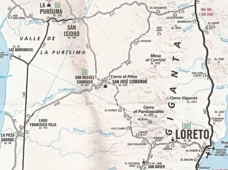
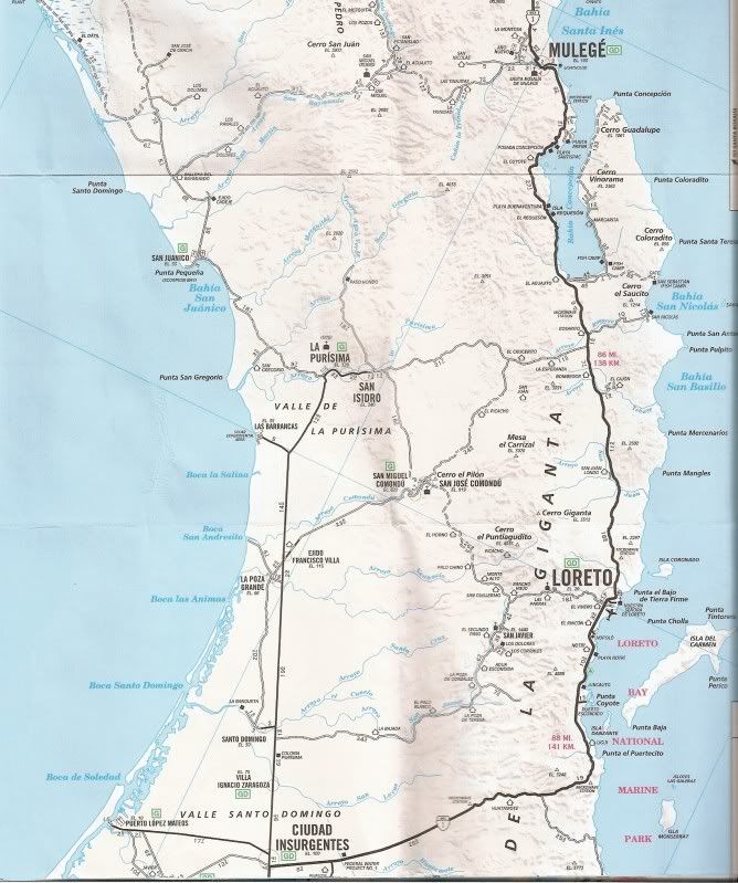
So last year I went to La Ventana. It was my first trip on the Baja and I had a blast. However, on the way back my buddies Garmin told me a great big
lie. I ended going straight past a place called Ciudad Insurgentes and ended up in a small town on what I can only describe as a jeep trail. I ended
up turning around and spending the night in my van well south of my intended target which was Guerrero Negro. Was I in fact passing through San
Isidro? I would remember but a year later I just don't. Does that off road trail end up back on pavement at some point? Just an FYI...Quigley makes
an awesome 4x4 system. It really pulled my ass out of the fire last year and I was too embarrassed to tell anybody what I did. 
|
|
|
bajaguy
Elite Nomad

Posts: 9247
Registered: 9-16-2003
Location: Carson City, NV/Ensenada - Baja Country Club
Member Is Offline
Mood: must be 5 O'clock somewhere in Baja
|
|
GPS lies
Always carry a back-up paper map
|
|
|
TMW
Select Nomad
Posts: 10659
Registered: 9-1-2003
Location: Bakersfield, CA
Member Is Offline
|
|
If you had stayed on the paved road north of Insurgentes and did not turn off it the pavement ends at La Purisima. If you kept going you would have
went thru San Isidro then make a left turn out to highway 1 on a graded road. If you did not make the left turn you would be going south to the
Comondu.
Did you ever think to stop and ask where am I and where to go. Next time get a map.
|
|
|
David K
Honored Nomad
Posts: 65509
Registered: 8-30-2002
Location: San Diego County
Member Is Offline
Mood: Have Baja Fever
|
|
Quote: Originally posted by josesbox  | | So last year I went to La Ventana. It was my first trip on the Baja and I had a blast. However, on the way back my buddies Garmin told me a great big
lie. I ended going straight past a place called Ciudad Insurgentes and ended up in a small town on what I can only describe as a jeep trail. I ended
up turning around and spending the night in my van well south of my intended target which was Guerrero Negro. Was I in fact passing through San
Isidro? I would remember but a year later I just don't. Does that off road trail end up back on pavement at some point? Just an FYI...Quigley makes
an awesome 4x4 system. It really pulled my ass out of the fire last year and I was too embarrassed to tell anybody what I did. |
|
|
|
bajaguy
Elite Nomad
Posts: 9247
Registered: 9-16-2003
Location: Carson City, NV/Ensenada - Baja Country Club
Member Is Offline
Mood: must be 5 O'clock somewhere in Baja
|
|
Go into your GPS settings and review what is selected. You may have to change the setting from "direct" or "shortcut" to another route/driving option.
You may also want to see if your GPS has the most current update and download from the Garmin site.
Also, never travel with a GPS alone. Get a paper map and do a route recon on the map so you have an indication the GPS is trying to re-route you
|
|
|
mtgoat666
Platinum Nomad
Posts: 20874
Registered: 9-16-2006
Location: San Diego
Member Is Offline
Mood: Hot n spicy
|
|
| Quote: Originally posted by josesbox | | So last year I went to La Ventana. It was my first trip on the Baja and I had a blast. However, on the way back my buddies Garmin told me a great big
lie. I ended going straight past a place called Ciudad Insurgentes and ended up in a small town on what I can only describe as a jeep trail. I ended
up turning around and spending the night in my van well south of my intended target which was Guerrero Negro. Was I in fact passing through San
Isidro? I would remember but a year later I just don't. Does that off road trail end up back on pavement at some point? Just an FYI...Quigley makes
an awesome 4x4 system. It really pulled my ass out of the fire last year and I was too embarrassed to tell anybody what I did. |
I use GPS when navigating in urban so cal, it's great, and gives me reliable voice directions.
I haven't used GPS in Baja for many years. Paper maps are more useful in Baja.
Now, it sounds like you were driving hwy 1 and went straight when you should have gone right. Even if you were operating on GPS, I can't imagine you
didn't see your mistake within 10 minutes of taking wrong turn. Sometimes you just need to pay attention, eh? Open your eyes, and put down the
electronic gadgets!
|
|
|
woody with a view
PITA Nomad
Posts: 15940
Registered: 11-8-2004
Location: Looking at the Coronado Islands
Member Is Offline
Mood: Everchangin'
|
|
How come the word ass isn't censored any longer?
|
|
|
Ateo
Elite Nomad
Posts: 5950
Registered: 7-18-2011
Member Is Offline
|
|
Hooray!
|
|
|
captkw
Ultra Nomad
Posts: 3850
Registered: 10-19-2010
Location: el charro b.c.s.
Member Is Offline
Mood: new dog/missing the old 1
|
|
Traveler's
don't want or use a gps for driving a car !!
|
|
|
AKgringo
Elite Nomad
Posts: 6334
Registered: 9-20-2014
Location: Anchorage, AK (no mas!)
Member Is Offline
Mood: Retireded
|
|
Let's hope some burro-hole doesn't abuse this new freedom and get the bad word police back on our burros!
If you are not living on the edge, you are taking up too much space!
"Could do better if he tried!" Report card comments from most of my grade school teachers. Sadly, still true!
|
|
|
AKgringo
Elite Nomad
Posts: 6334
Registered: 9-20-2014
Location: Anchorage, AK (no mas!)
Member Is Offline
Mood: Retireded
|
|
I use a GPS while I am driving in the Baja, but the information is frequently incorrect, even with the most recent updates. I have never
been guided to the correct set of detours to get in the right lane for a north bound border crossing.
I had fewer problems using a TomTom, than with a POS Garmin that I used in 2013, but with both of them I double check against a AAA Baja map if I
think I am being lied to.
If I was making the drive you mentioned (La Ventana to Guerrero Negro) I would pre-enter all of the towns I expected to drive through and change my
destination to the next one as I approached each town. That should get you on the best route through a town, and you will always have an Idea how far
the next community will be.
I also use the GPS on back roads, because the main road sometimes looks less traveled than a dead end ranch road. Even that can be a trap! I found a
road headed north from San Juanico to San Ignacio that doesn't show up on my map, but Garmin assured me that it was the way!
Sometimes it can be amusing, such as when I watched the icon of my SUV trolling just off shore while driving roads behind the beach south of Punta
Conejo! As of Nov 2014, neither of the units I used is aware there is a paved road from Los Barriles to El Cardonal, and kept telling me to bush wack
over to the dirt road on the coast!
For that matter, I don't see that road on my AAA map either, but it is not brand new! Anyway, for information, and amusement, I use a GPS, and a bit
of common sense,which for me is also unreliable !
If you are not living on the edge, you are taking up too much space!
"Could do better if he tried!" Report card comments from most of my grade school teachers. Sadly, still true!
|
|
|
Udo
Elite Nomad
Posts: 6364
Registered: 4-26-2008
Location: Black Hills, SD/Ensenada/San Felipe
Member Is Offline
Mood: TEQUILA!
|
|
My Garmin is updated every 6 months or so. And I too find it amusing to be driving over water via the GPS co-ordinates. I will take a photo of the
phenomenon next time it happens and post it here.
| Quote: Originally posted by AKgringo |
Sometimes it can be amusing, such as when I watched the icon of my SUV trolling just off shore while driving roads behind the beach south of Punta
Conejo! |
Udo
Youth is wasted on the young!
|
|
|
Bajahowodd
Elite Nomad
Posts: 9274
Registered: 12-15-2008
Location: Disneyland Adjacent and anywhere in Baja
Member Is Offline
|
|
OK. I'm a geezer. But have never used GPS for two reasons. I have always had a great innate sense of direction, and refuse to rely on a device which
at the end of the day is garbage in, garbage out.
Driven in somewhere near two dozen countries, and NEVER thought I would need GPS. Never did.
|
|
|
David K
Honored Nomad
Posts: 65509
Registered: 8-30-2002
Location: San Diego County
Member Is Offline
Mood: Have Baja Fever
|
|
Where GPS street directions is helpful in Mexico is in cities or nighttime conditions if you get put on the typical "no signed" detour routes. Getting
across Ensenada when a parade closed the usual route was the one time my TomTom GPS with Mexico maps was helpful. Most of the rest of Baja I have
pretty well imprinted with paper and wall maps that decorate my walls!
|
|
|
gsbotanico
Nomad
Posts: 209
Registered: 7-28-2015
Location: Cardiff by the Sea, CA
Member Is Offline
|
|
My solution often is to simply stop and ask someone. Of course, this requires a certain level of proficiency in Spanish, but a local can always get
you going in the right direction. My SUV has a built in compass which also helps. On little traveled roads I've even flagged down an approaching
vehicle to ask.
The one time I got snookered was in the lowland jungles of Chiapas looking for a jungle lodge on a dirt road 40 miles off the paved highway. Mileage
showed we should have arrived. I stopped at a jungle hut to ask, but the owners did not speak Spanish, only Mayan! Fortunately a pickup with local
farmers who spoke Spanish came by and told us we had missed the turnoff a few miles back.
In Baja any rancher or driver in the rural areas will help. In urban areas I always stop at the corner grocery store. If the owner doesn't know,
he/she will ask someone who does. The question to ask in Spanish is: ¿Por donde se va a ...? What is the way to ...? Just add the name of the of
the next important town, hotel, or place you are looking for.
|
|
|
wilderone
Ultra Nomad
Posts: 3903
Registered: 2-9-2004
Member Is Offline
|
|
Even a map - if it's wrong - will lead you astray. Local people know best, but sometimes difficult to understand directions if you don't know the
language well. I was directed down a logging road - not on the map - to see some lakes, and was told to go to Santa Maria to see an archaeological
ruin in Yucatan couple weeks ago. Never saw the lakes - no signs. Kept driving - sprained my wrist pulling a tree out of the road. Never saw the
ruins - no signs, and when I finally got to Santa Maria - not on the map - and asked about the ruins that were supposed to be there, was told, You
passed them. Looked on the map - Nohbec next - how do I get to Nohbec. "It's on the other side" she kept telling me. So, I don't go straight on
this road? No. It's on the other side. Otro cada de QUE, I asked. The plaza, turns out. Make a left at the mercado she says. Got to Nohbec; the map
shows you can go straight or cross over. Drive past the cemetary - the straight road - which deteriorated into a rocky two track. Asked the guys at
the cemetary, my map shows this goes straight to Hwy 307. No, it's not a good road - go back and cross over through town to Los Limones. Go back to
middle of town, and ask someone which street to cross over - they all cross over. Don't the streets have names I ask? He laughs. No, in this town
the streets don't have names. Go to the green house on the corner on that side of the street, two blocks down and turn left. I pass 3 green houses,
but come to one on the corner, and take a wild guess. Finally get on the main highway. I ask about a camping place - there's a very small sign at a
jungle entrance that I would have missed had I not been told by the pineapple ladies. Ended up with a lakeside, palapa roofed campsite - not on the
map - ham dinner and margarita in hand at the end of the day. Life is good.
|
|
|


