kathienpb
Newbie
Posts: 5
Registered: 12-24-2016
Member Is Offline
|
|
Road flooding-Rosarito to Otay
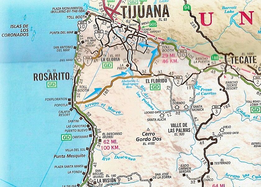
Hi, I'm new here so this may be a stupid question for everyone who's been here forever, but I'm wondering if there is a place to go to see road
closures in Tijuana? I need to go to the border over the next couple weeks and with so much rain, I'm not sure my little Celica will be able to
handle the flooding. My Jeep is in the shop. Google maps doesn't show road closures until weeks later. I'm just wondering if the roads from
Ensenada/Rosarito to Otay will be flooded or not.
|
|
|
bajaguy
Elite Nomad

Posts: 9247
Registered: 9-16-2003
Location: Carson City, NV/Ensenada - Baja Country Club
Member Is Offline
Mood: must be 5 O'clock somewhere in Baja
|
|
All roads will experience flooding during a hard rain.
Several intersections along Industrial Blvd in Otay were flooded, Via Rapida and Blvd International were flooded in TJ
Give it a few days and everything will be back to normal, except with new potholes
|
|
|
kathienpb
Newbie
Posts: 5
Registered: 12-24-2016
Member Is Offline
|
|
Thanks, 
I don't think I have to take Industrial Blvd but I do cross it.
I usually take the 1D to the 1 to the 2 and then Otay Blvd. I'm mostly worried about Lazaro Cardinas, since that dips really low in a couple of
places.
Or would San Ysidro be better?
I can never find my way to the ready lane in San Ysidro.
I'm still trying to figure everything out here, it was a bad time for someone to hit my Jeep. I really need it right now.
|
|
|
John M
Super Nomad
Posts: 1924
Registered: 9-3-2003
Location: California High Desert
Member Is Offline
|
|
Ready lane
If you go to the title sponsor above, Baja Bound Insurance, follow a couple of links and you'll find driving directions to the ready lane, SENTRI, and
fast pass.
I'm assuming they are up to date.
John M
|
|
|
bajaguy
Elite Nomad
Posts: 9247
Registered: 9-16-2003
Location: Carson City, NV/Ensenada - Baja Country Club
Member Is Offline
Mood: must be 5 O'clock somewhere in Baja
|
|
Sorry, can't help you on that. Always cross north at the Otay SENTRI and south through San Ysidro
Thursday headed south after crossing along the border fence, roads were flooded, traffic backed up and several cars stalled out due to driving too
fast through the flooded sections.
The Otay Ready Lane approach looked good from the TJ airport road
[Edited on 12-24-2016 by bajaguy]
|
|
|
kathienpb
Newbie
Posts: 5
Registered: 12-24-2016
Member Is Offline
|
|
That's how I usually go, north through Otay and south through San Ysidro, along the toll road
Ugh, maybe I will take a cab, I'm sure they know how to drive in this. Now I'm worried if I can get back home when I leave! 
Thanks so much for your input.
|
|
|
David K
Honored Nomad
Posts: 65565
Registered: 8-30-2002
Location: San Diego County
Member Is Offline
Mood: Have Baja Fever
|
|
What about the Corredor 2000 from the south side of Rosarito (Popotla) to the Otay border, via Industrial? There can't be an easier way to the border
from south of Rosarito, can there?
|
|
|
bajaguy
Elite Nomad
Posts: 9247
Registered: 9-16-2003
Location: Carson City, NV/Ensenada - Baja Country Club
Member Is Offline
Mood: must be 5 O'clock somewhere in Baja
|
|
Corridor 2000 and Industrial are not rain friendly. flooding areas, rocks and dirt washed down from the hills on 2000 and flooding on Industrial
between Calle 2nd Norte and Planas
|
|
|
kathienpb
Newbie
Posts: 5
Registered: 12-24-2016
Member Is Offline
|
|
Is any of that road flooded?
The way I go is actually really easy. Google maps works really well here, unless you're actually in Tijuana, then it loses you sometimes.
I think coming back might be bad too but if you get through the Playas it might be okay.
Mexico (and San Diego) were not built for rainy days...
I found an App on the Mexico government website, do you know if that really works?
|
|
|
bajaguy
Elite Nomad
Posts: 9247
Registered: 9-16-2003
Location: Carson City, NV/Ensenada - Baja Country Club
Member Is Offline
Mood: must be 5 O'clock somewhere in Baja
|
|
I don't use apps, I have a Garmin GPS that works great in Baja. I use Google maps to plot out a Plan B if necessary.
Did the trip Thursday, not fun, but driving carefully was no problem
Sorry, don't know anything about a government app
Quote: Originally posted by kathienpb  | Is any of that road flooded?
The way I go is actually really easy. Google maps works really well here, unless you're actually in Tijuana, then it loses you sometimes.
I think coming back might be bad too but if you get through the Playas it might be okay.
Mexico (and San Diego) were not built for rainy days...
I found an App on the Mexico government website, do you know if that really works? |
|
|
|
kathienpb
Newbie
Posts: 5
Registered: 12-24-2016
Member Is Offline
|
|
Thanks
I wasn't able to download the app (I'm not sure why they rolled it out but it doesn't even look like it's completed) but thanks for the great tips.
It looks like the rain is out of the forecast now, hopefully it stays away until I get my jeep back!
Be safe everyone.
Kathie
|
|
|
gsbotanico
Nomad
Posts: 209
Registered: 7-28-2015
Location: Cardiff by the Sea, CA
Member Is Offline
|
|
No matter which way you go, you many encounter flooded areas or mudslides after heavy rains. This is normal. They drain or are cleared in a day or
two. It's much better than it was many years ago. Many of the worst areas have been fixed, like coming downhill at the cinco-diez just before
crossing the railroad tracks heading to the Otay crossing.
To get to the Sentri lanes at San Ysidro, you have to get to Blvd. Padre Kino. Use either the roundabout at the Cultural Center with the very large,
slender "V" in the middle or the next one with the Cuauhtémoc Indian stature in the middle. Go east to cross the river channel. Both give access to
Padre Kino and are signed once heading into Padre Kino. Do it the first time or two with minimum traffic, otherwise the hectic traffic makes it hard
to concentration on the signage
|
|
|


