| Pages:
1
2 |
David K
Honored Nomad

Posts: 65551
Registered: 8-30-2002
Location: San Diego County
Member Is Offline
Mood: Have Baja Fever
|
|
Quote: Originally posted by 4x4abc  | still trying to make sense of the 1930's road around Rancho Canipolé
the remnants on the ground show different than the maps
I know the scale is not that accurate, but some vitals are missing |
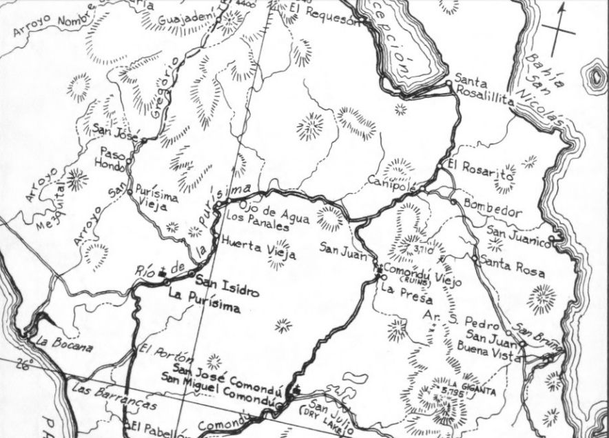
The 1962 maps by Howard Gulick are very accurate and the roads are probably the same as shown on the 1941 map (not as accurate). Canipolé was indeed
on the main road to La Paz and the side road to Loreto branched there:
[Edited on 3-21-2019 by David K]
|
|
|
4x4abc
Ultra Nomad
Posts: 4455
Registered: 4-24-2009
Location: La Paz, BCS
Member Is Offline
Mood: happy - always
|
|
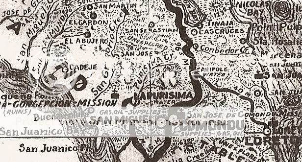
Gulick's map shows the new Old Road
AAA shows the old Old Road
I took the liberty and put the 1930's road into Gulick's map
main point is that the 1930's road does not hit Rancho Canipolé from the north
for the last 3 miles it is coming from the southwest
that 1930's road is one of the coolest in Baja - a little rough for 4x4 (I have done most of it) - easy for bikes

Harald Pietschmann
|
|
|
4x4abc
Ultra Nomad
Posts: 4455
Registered: 4-24-2009
Location: La Paz, BCS
Member Is Offline
Mood: happy - always
|
|
I am proposing that the AAA map was wrong when it comes to Canipolé
correction below - Canipolé needs to be moved to the new intersection
and of course there is no Conbedor Cr.

Harald Pietschmann
|
|
|
4x4abc
Ultra Nomad
Posts: 4455
Registered: 4-24-2009
Location: La Paz, BCS
Member Is Offline
Mood: happy - always
|
|
here is today's layout

Harald Pietschmann
|
|
|
David K
Honored Nomad
Posts: 65551
Registered: 8-30-2002
Location: San Diego County
Member Is Offline
Mood: Have Baja Fever
|
|
Nice Harald... the 1941 map is not an AAA map, fyi.
|
|
|
4x4abc
Ultra Nomad
Posts: 4455
Registered: 4-24-2009
Location: La Paz, BCS
Member Is Offline
Mood: happy - always
|
|
I will change my records
Harald Pietschmann
|
|
|
defrag4
Senior Nomad
Posts: 536
Registered: 2-5-2011
Member Is Offline
|
|
| Quote: Originally posted by 4x4abc | Gulick's map shows the new Old Road
AAA shows the old Old Road
I took the liberty and put the 1930's road into Gulick's map
main point is that the 1930's road does not hit Rancho Canipolé from the north
for the last 3 miles it is coming from the southwest
that 1930's road is one of the coolest in Baja - a little rough for 4x4 (I have done most of it) - easy for bikes
|

tell me more about this 1930 road?
|
|
|
4x4abc
Ultra Nomad
Posts: 4455
Registered: 4-24-2009
Location: La Paz, BCS
Member Is Offline
Mood: happy - always
|
|
between 11 and 18 ft wide
some washouts
check it on Google Earth
starts here 26°32'33.94"N, 111°45'51.15"W
ends here 26°22'53.63"N, 111°42'6.57"W
Harald Pietschmann
|
|
|
4x4abc
Ultra Nomad
Posts: 4455
Registered: 4-24-2009
Location: La Paz, BCS
Member Is Offline
Mood: happy - always
|
|
alternative end here: 26°21'32.81"N, 111°48'20.04"W
beautiful drive!
Harald Pietschmann
|
|
|
David K
Honored Nomad
Posts: 65551
Registered: 8-30-2002
Location: San Diego County
Member Is Offline
Mood: Have Baja Fever
|
|
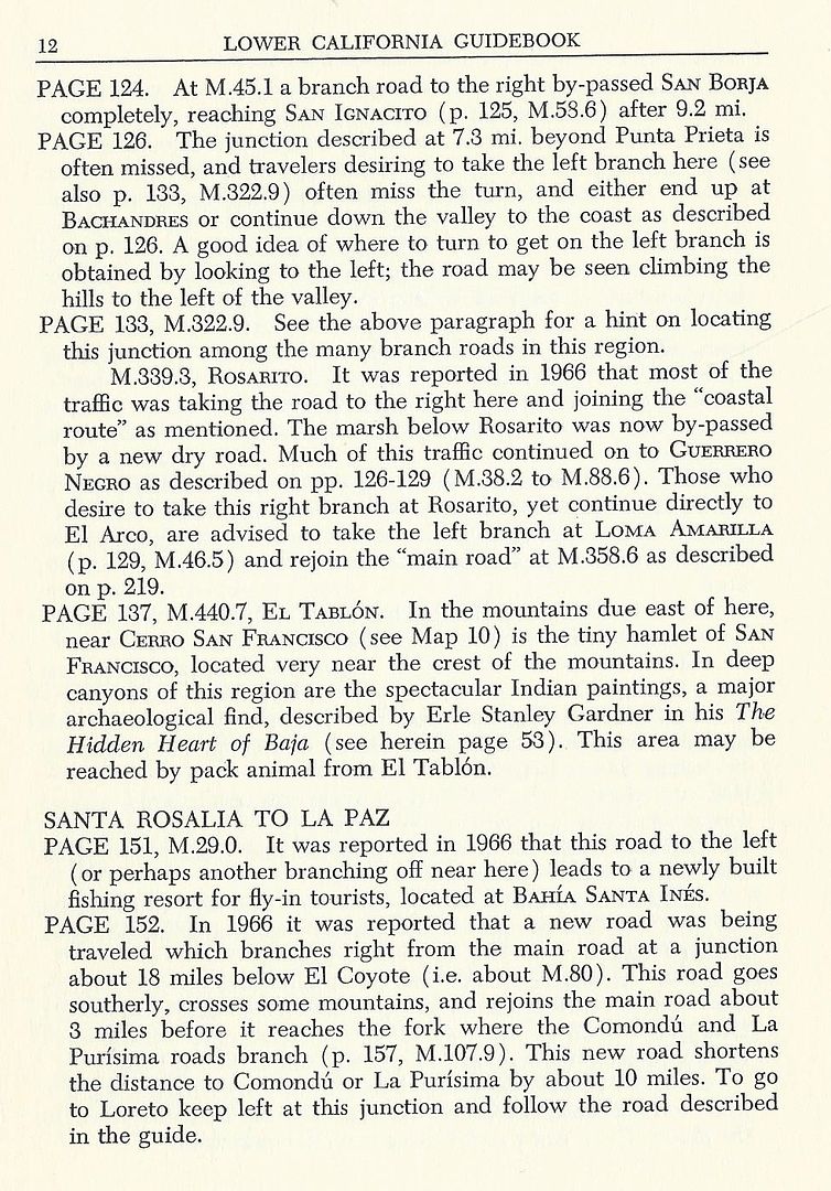
The 1941 map is not accurate as drawn (and you nicely added to the 1962 map). It was actually a "new" route made as a short cut. in the early 1960s,
after the 1962 edition of the Lower California Guidebook. They mention it in the revised 1967 guidebook. My parents and I took it in 1966, as well.
See the bottom (Page 152) entry from this 1967 edition of the guidebook:
|
|
|
| Pages:
1
2 |


