Maderita
Senior Nomad

Posts: 704
Registered: 12-14-2008
Location: San Diego
Member Is Offline
|
|
Picacho del Diablo, Pinnacle Ridge route, sub-16 hours
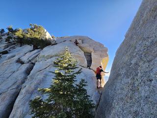
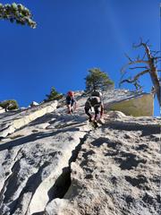
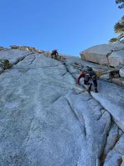
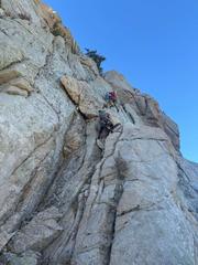
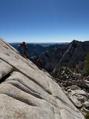
A trip report came in from a SoCal climber. He and two partners from Colorado ascended Picacho Del Diablo (aka: Cerro de la Encantada or Cerro
Providencia) 10,157' (3,096 m) via the Pinnacle Ridge route on November 8, 2025. In a blazing fast time of 15 hours, 57 minutes, car to car!
To my knowledge, every prior ascent made at least one bivouac on a multi-day ascent. They reported an initial 120' section of 5.7 difficulty, for
which they used a rope and protection. The remainder of the very long ridge was completed free-solo (without ropes). With skilled downclimbing and
intricate route finding, they were able to avoid doing any of the formerly mandatory rappels.
Their approach passed the Cerro Botella (Blue Bottle Peak) saddle to reach the Pinnacle Ridge. After traversing the ridge, they ascended the South
summit, then the North summit, before descending the normal route down "Wall Street" to Campo Noche on the canyon floor. Headlamps were needed as they
ascended from Campo Noche to the trail and parking area.
Congratulations to David, Will, & Ryan who were just out having fun, though almost certainly set a new record.
|
|
|
mtgoat666
Platinum Nomad
Posts: 21147
Registered: 9-16-2006
Location: San Diego
Member Is Offline
Mood: Hot n spicy
|
|
There used to be a worker at the observatory who was an endurance runner, climber. He would frequently do 1-day run/climbs of picacho el diablo. Not
sure if he did the reg route, ridge, or both. Met him years ago on a hike north of the observatory around cerro venado blanco, as he was running the
old road and trail. I think he only lived up there for a few years.
Woke!
Hands off!
“Por el bien de todos, primero los pobres.”
“...ask not what your country can do for you – ask what you can do for your country.” “My fellow citizens of the world: ask not what America
will do for you, but what together we can do for the freedom of man.”
Pronoun: the royal we
|
|
|
Maderita
Senior Nomad
Posts: 704
Registered: 12-14-2008
Location: San Diego
Member Is Offline
|
|
Quote: Originally posted by mtgoat666  |
There used to be a worker at the observatory who was an endurance runner, climber. He would frequently do 1-day run/climbs of picacho el diablo. Not
sure if he did the reg route, ridge, or both. Met him years ago on a hike north of the observatory around cerro venado blanco, as he was running the
old road and trail. I think he only lived up there for a few years. |
mtgt666, That must have been an interesting chance encounter with the worker.
My words were taken out of context. The subject is the Pinnacle Ridge route. I will rephrase it: To my knowledge, every prior
car-to-car ascent of Pinnacle Ridge to the summit made at least one bivouac on a multi-day ascent. Sorry to
disappoint, but that worker certainly did not rope-solo, nor free-solo, Pinnacle Ridge.
|
|
|
David K
Honored Nomad
Posts: 65581
Registered: 8-30-2002
Location: San Diego County
Member Is Offline
Mood: Have Baja Fever
|
|
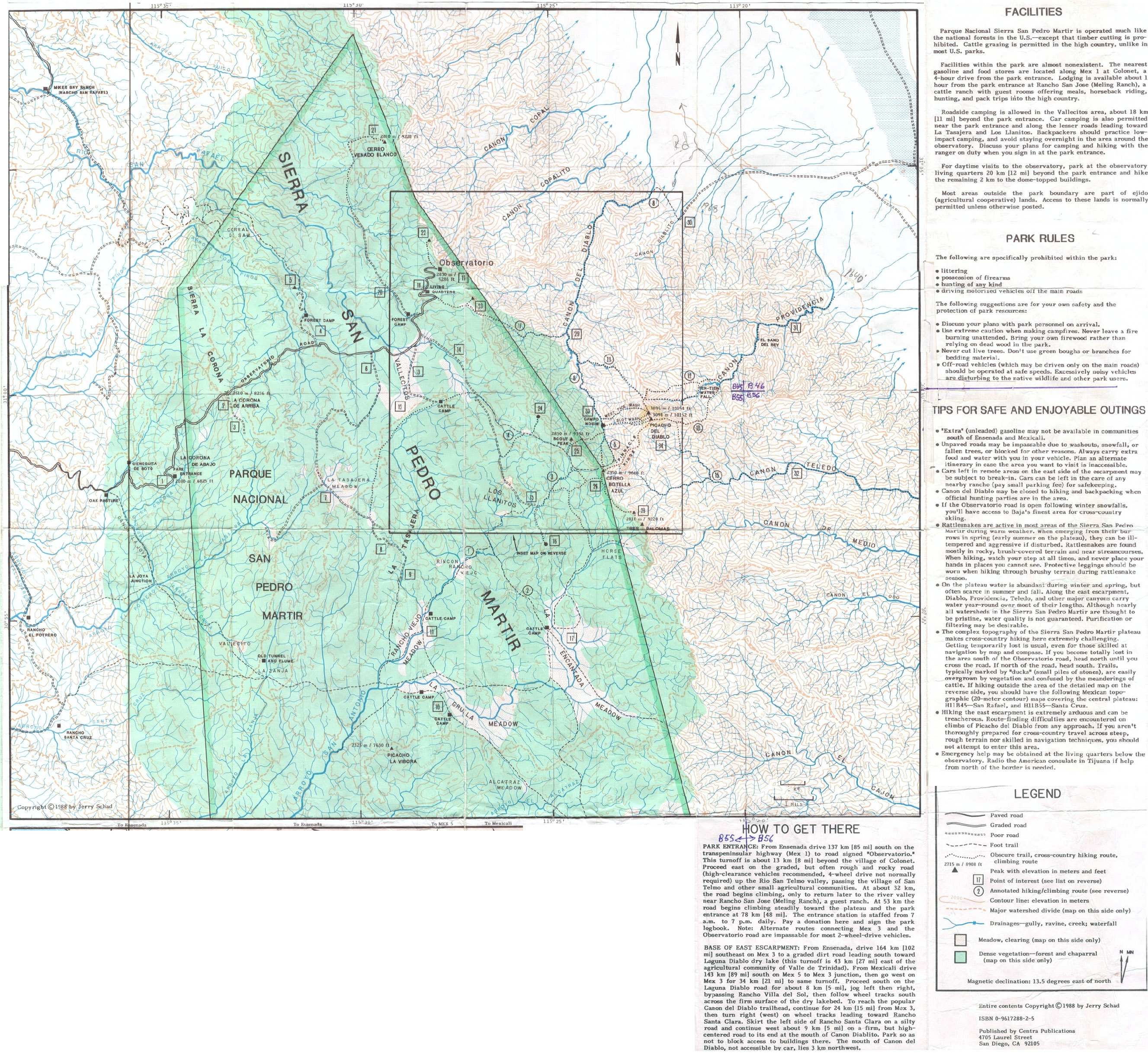
Thank you John for the interesting post! If I can be of assistance in posting (these or more) photos here or on Facebook to share, let me know.
Here are the climbing route maps (from vivabaja.com/maps):
1988 Jerry Schad Observatories to Diablo Mountain
1988 Jerry Schad San Pedro Mártir
|
|
|
Maderita
Senior Nomad
Posts: 704
Registered: 12-14-2008
Location: San Diego
Member Is Offline
|
|
Thanks for posting your links, David. Jerry Schad's maps and route info are detailed and very helpful.
|
|
|
Vince
Nomad
Posts: 448
Registered: 10-17-2006
Location: Coronado
Member Is Offline
|
|
That was a fast trip! I climbed it with some Coronado friends and my brother, Mike, in 1955. Bud Bernard led us up to the summit, South as I
remember. About half way up a gorge we had to swim across a deep pool of clean, clear water and belay our packs and clothes up over a waterfall with
ropes. Then on to a base camp where we left packs and gear for the ascent. The next day Bud led us up to the south summit, then he went over to the
north summit with a transit or measuring device to determine which peak is the highest. I can't remember the result, but he wrote it down somewhere.
Then back to the base camp for a good night's rest. Back down the mountain which would make it three days, car to car. We did it over Easter
vacation and it left us with some long lasting memories for a 16 year old kid.
|
|
|
Maderita
Senior Nomad
Posts: 704
Registered: 12-14-2008
Location: San Diego
Member Is Offline
|
|
Vince,
Thanks for sharing your trip report. Some very significant history in your ascent! You were indeed a fortunate teen to accompany the legendary Bud
Bernard on such a wild adventure in 1955! The 1955 route ascended what has become the standard route, except that you veered to the right to attain
the South summit. See route #9 on David's link here: https://octopup.org/img/media/maps/baja/1988--Picacho-Del-Di...
Now, almost everyone continues straight up, on a smooth granite slab/dihedral called "Wall Street" to the North summit, which is slightly higher than
the South summit.
By the way Vince, 3 days was a very respectable time when approaching from the northeast and hiking the very long and rugged Diablo Canyon.
As a teen, I heard fascinating accounts of Bud Bernard finding the 1967 lost Dart-Kellogg party on the mountain. The San Diego Mountain Rescue Team
guys were likely embellishing the stories after some quantity of alcohol was consumed in the Sierra Club Lodge. https://www.sandiegouniontribune.com/2017/05/01/san-diego-mo...
|
|
|
David K
Honored Nomad
Posts: 65581
Registered: 8-30-2002
Location: San Diego County
Member Is Offline
Mood: Have Baja Fever
|
|
Bud's maps
Our late Nomad friend 'Barry A' (formerly of Coronado, CA) provided us a couple of Bud's maps showing both the Sierra San Pedro Mártir and the
canyons facing Valle Chico...
1962 Bud Bernhard Canyons Map
1963 Bud Bernhard S.P. Mártir Plateau Map
|
|
|


