David K
Honored Nomad

Posts: 65544
Registered: 8-30-2002
Location: San Diego County
Member Is Offline
Mood: Have Baja Fever
|
|
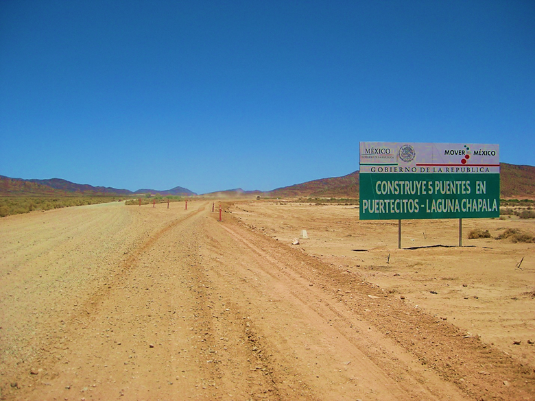
The Progress of Paving Hwy 5 (Puertecitos to Laguna Chapala)
On my VivaBaja Facebook group is this post of my documentation of the progress of Mex #5. This was a BIG topic during those years, here on Nomad...
We were verbally betting when it would be finished.
Building Hwy. 5 from Puertecitos to Hwy. 1 (Laguna Chapala):
Feb. 2007: No new road work.
Sept. 1, 2008:
Less than 2 miles from the Puertecitos road, the asphalt ends. Heavy duty construction continues for another few miles. A detour down to the older
route is just ahead.
Here is the Hwy. 5 road log from July 19, 2010:
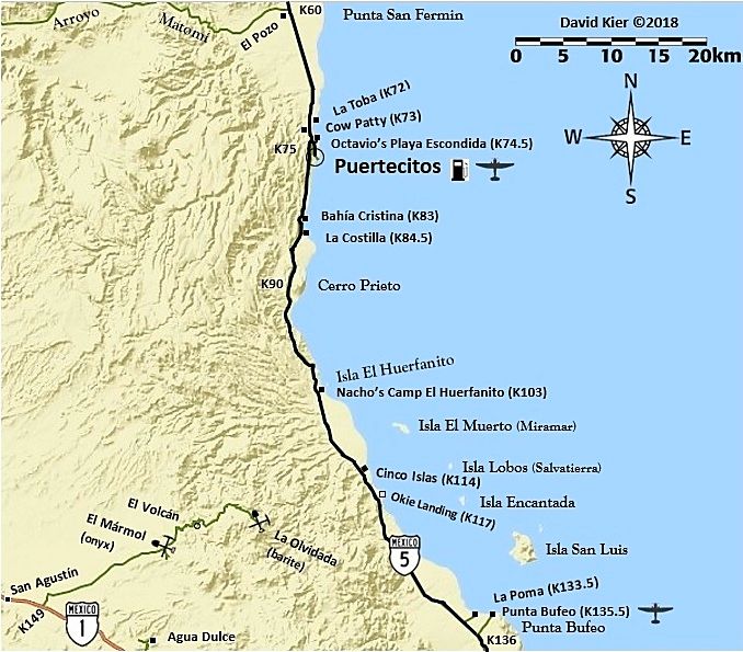
0.0 (0 min.) Puertecitos Entrance Road, sign ahead for Laguna Chapala.
5.2 (6 min.) Playa Cristina
6.2 La Costilla
17.6 (20 min.) El Huerfanito (off to east of highway, no sign)
18.5 Detour off pavement onto older road, regraded for construction traffic. Piles of sand on road mark this point, no sign. Ahead on pavement is sign
for Campo Tano at Mile 19.0. At 19.3 is a sign ‘End of Pavement, 200 mtrs.’). At 19.5 is the absolute end at an unfinished bridge. No sign of road
work on the opposite side of arroyo. Road work does continue beyond, out of sight from here.
Return back to Mile 18.5, detour onto dirt… log continues from this point.
25.1 (34 min. from Puertecitos, not including run to end of pavement) End of new road construction alongside old road. Old road new grading ends…
very rough, rocky road on to Gonzaga. Motorhomes and trailers should avoid!
26.0 ‘Okie Landing’ to east (note cement pads along end of gravel beach marking the fish camp of the 1960’s).
33.1 (1 hr. 14 min.) Campo Delfines
36.3 (1 hr. 26 min.) Las Encantadas
37.9 (1 hr. 31 min.) Punta Bufeo
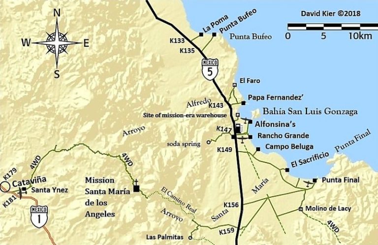
43.1 (1 hr. 59 min.) El Faro
43.4 (2 hr. 1 min.) Papa Fernandez’ Bahia San Luis Gonzaga
Military Checkpoint is just a mile + ahead.
46.1 (2 hr. 12 min.) Alfonsina’s Pemex (closed from 2-4 pm), Rancho Grande Market just ahead on right.
Clear odometer for next section… The main road south from Gonzaga is much better than the road north, but the rough surface still limits maximum
speed to ~30 mph (twice that of the north section) in a Tacoma, loaded.
0.0 Rancho Grande ‘Gonzaga Bay’
1.3 (8 min.) Road to Campo Beluga and Sacrificio
7.5 (22 min.) Road west to Arroyo Santa Maria and Las Palmitas oasis on the old mission trail ‘El Camino Real’
10.0 (28 min.) Road in from left is the south access route to Punta Final
16.7 La Turquesa Canyon road to west (green pools of water, turquoise mine, and very difficult off road and abandoned mine road shortcut to Hwy. 1
near El Pedregoso)
19.2 (52 min.) Las Arrastras site access road. Gold ore grinding mills, well, nearby waterhole of San Francisquito on the Camino Real.
23.0 (1 hr.) Coco’s Corner (cold Pacifico for sale $2) Coco in Ensenada, helper Ramón on hand.
36.1 (1 hr. 30 min. driving time) HWY. 1, Laguna Chapala. Gasoline and tire repairs advertised, 1 km. south.
July 3, 2011:
We took mileage notes this day and were on the new paved highway for 24.1 miles from the Puertecitos jcn.. The kilometer markers are from the San
Felipe airport road (Km. 0) to El Huerfanito and then change to bigger numbers south of El Huerfanito… as if from Mexicali. The detour off the
pavement was near Km. 318… and the older road has been regraded smoother (for highway crews) for another 7.9 miles (almost to Campo Delfines).
The pavement ends just 1.4 miles from the site of Okie’s Landing…
The rough, older road lasts for just 10.4 miles to Papa Fernandez’ road and improves greatly for the remaining 36 miles to Hwy. 1
The military checkpoint, 1.2 miles south of Papa Fernandez’ road was open. It was after 2 pm and the Pemex at Alfonsina’s was closed for siesta
(2-4) as before.
Here is my record of the progress of the new highway south from Puertecitos in the years up to 2012:
NOV. 2006: Paved to 3 miles north of Puertecitos.
FEB. 2007: Paved to Puertecitos, except for a 1.8-mile section.
SEPT. 2008: Paved to 2 miles south of Puertecitos.
JAN. 2009: Paved to 4 miles south of Puertecitos. (2 mi., in 3 mos.)
SEPT. 2009: Paved to 10 miles south of Puertecitos. (6 mi., in 9 mos.)
JULY 2010: Paved 19 miles south of Puertecitos. (9 mi., in 10 mos.)
JULY 2011: Paved 24 miles south of Puertecitos. (5 mi., in 12 mos.)
JAN. 2012: Paved 33 miles south of Puertecitos. (9 mi., in 6 mos.)
July 15, 2012:
The Puertecitos road is at Km. 74.5 and the new, wider, high speed highway begins here. The 52-mile highway from San Felipe to Puertecitos is an older
style, narrow paved road with sudden, steep vados (dips) that prohibit high speed. I reset my Tacoma’s trip odometer at the Puertecitos junction to
note the mileage where the new pavement has reached, and other points south.
Playa Cristina is at Mile 5.0, La Costilla is at Mile 6.1, the wide turnout with the view of the Enchanted Islands is at Mile 14.7 and just before Km.
100 marker. Okie Landing (a fishing ‘resort’ from the 1960’s with just concrete slabs remaining) is at Mile 25.5/ Km. 117. The pavement ended
just north of here one year ago.
The end of pavement this trip is at Mile 31.3, just beyond Km. 126. That is almost 6 miles (10 km.) added in one year. This is no rush job, but the
quality of the highway is fantastic, with a 110 kph (~70 mph) speed limit. Turnoffs to Campo Delfines is at Mile 31.9, Punta Bufeo is at Miles 36.6,
Papa Fernandez’ is at Mile 41.7, Military checkpoint is at Mile 42.8, and the Pemex gas station/ Alfonsina’s road/ Rancho Grande store are at Mile
44.2 from Puertecitos road and the time was 10:06 am.
The remaining unpaved road to Bahia San Luis Gonzaga is graded smooth. From the end of pavement to the Pemex and Rancho Grande is 12.9 miles. We
topped the gas tank at Gonzaga Bay. Trip odometer reset to 0.
Las Palmitas oasis/ El Camino Real access road is at Mile 7.2, the first boojum (cirio) trees were at Mile 13.9, and Coco’s Corner is at Mile 22.4.
We were at Coco’s from 11:00 to 11:52 am. [We went on via Calamajué Canyon this trip]
July 22, 2015:
The Puertecitos road junction is at Km. 74.5, and we pass it at 9:30 am, 52 miles from the San Felipe traffic circle, 30 miles south of Shell Island
road. The new Puertecitos roadbed was constructed in 1982 and then paved several years later. It is an old style rural road, very narrow, with many
steep dips across arroyos (usually dry washes). It cannot be driven at high speed because of these sudden surprise dips (vados). The paving was
originally so thin, it was in ruins by the late 1990’s. It was repaved around 2005-2006.
The viewpoint of the Enchanted Islands is at Km. 99. The highway south of Puertecitos is a totally different story. It is a wide, two lane road with
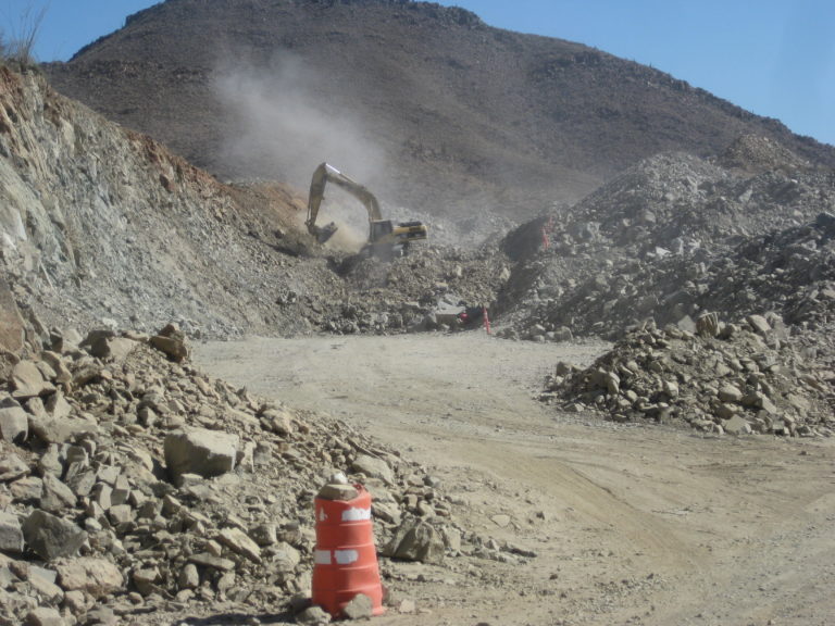
paved shoulders, bridges and culverts instead of dips, and a higher speed limit. This new highway construction began in 2007 and has progressed south
an average of 12 kilometers a year, so far. The pavement ends 96 kilometers (almost 60 miles) south of Puertecitos currently and has for the past half
year. New construction is ongoing as they blast through mountains for the final 20 some miles to Highway 1 at Laguna Chapala. The alignment is
slightly different than of the current road for part of the way. It will be about 2 miles west of Coco’s Corner.
A military checkpoint is located in the Gonzaga Bay area, and we are waved through with smiles. We stop at the gas station located at the road to
Alfonsina’s Resort, Gonzaga Bay. The time was 10:30 am. Here gas was slightly different price than all others in Baja, at 14.08 pesos/liter
(US$3.57/gallon). Less than 10 gallons tops my tank. On our return trip north, four days later, the station was closed. Never pass an open station
without enough gas to reach the next one! Just past the Alfonsina’s road is the Rancho Grande airstrip and road on the left, and their market on the
right. The market has ice, liquor, food. Behind it is a tire shop. We get some ice and beer and leave Rancho Grande at 10:53 am.
The end of the paved highway, 20 kms. south of Gonzaga Bay Pemex station, in 2015. This begins an area of huge granite boulders for the next 6 miles
to Las Arrastras, the site of a gold ore mill and a former ranch. The foundations remain, and in the arroyo below are the stone mills (arrastras) and
well. The highway construction uses the well to fill water trucks. Here the new highway route leaves the former road and heads straight south. The
current road curves east and goes to Coco’s Corner, 3.8 miles from Las Arrastras.
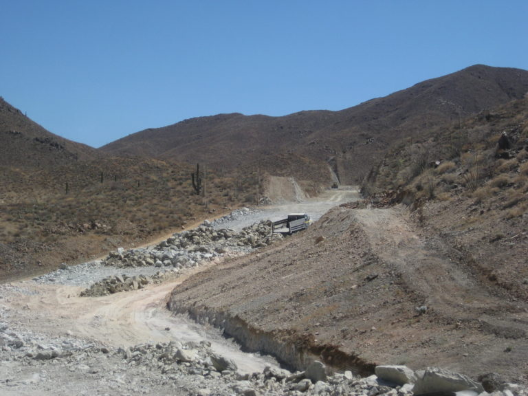
New highway construction was reached 3.7 miles from Coco’s and lasted for 3 miles. The crews are taking down whole mountains from the top to create
a straight-as-possible alignment. It may be several years before the last 20 some miles to Highway 1 is completed [It took 5 years]. The current road
is very rough, being used for construction vehicles, trucks, and anyone else. With my heavy load of camping gear and ice chests, I had to slow to 10
miles an hour for some of the distance over the mountain from Coco’s to Laguna Chapala. 13 miles from Coco’s Corner we arrived at Highway 1 at
1:03 pm. I aired up the tires (dropped them to 25 psi for the rocky road to prevent flats), and we had some snacks and beer. Southbound at 1:30 pm.
July 10, 2016:
Km. 74.5 Puertecitos Junction 9:30 am
Km. 99 is the view pullout for the Enchanted Islands. We leave at 11:07 after having sandwiches.
Km. 147 is the Pemex and across the way, the Rancho Grande store. 11:38 am.
The Campo Beluga road is 1.2 miles south (Km. 149). A news note, Alfonsina’s son (Roman) no longer owns that Pemex, it was sold to a group that runs
several Pemex stations in Baja.
Km. 159 (7.2 mi from Pemex) Las Palmitas road and it has some activity on it. This was the access to the El Camino Real trail to Mission Santa María
and the oasis of Las Palmitas.
END OF PAVEMENT (same as it was in Jan. 2015). Km. 167.5, 12.4 miles south of the Pemex. It is 11:50 am.
We see about three completed bridges… and many just started bridges and little else change in the canyon in the past 12 months.
18.5 miles from Gonzaga Pemex is the Las Arrastras historic site (see my July 2015 trip report), currently a road construction camp. 12:07 pm. The new
highway heads straight south from here (or will when open) while the old road curves to the left and heads for Coco’s Corner.
Mile 22.5 from Pemex is Coco’s Corner. 12:17 pm.
Mile 27.2 come along new road construction in the canyon. The past 4.7 miles from Coco’s are the roughest of all the miles.
No work was in progress except for a water truck we saw driving on the new roadbed, across the Chapala Valley, where it is a bit south of the old
road.
HWY. 1 Laguna Chapala 35.4 miles from Gonzaga Pemex. 23.0 unpaved miles. 1:03 pm
Jan. 2017:
Km. 74.5 is the paved road for Puertecitos and the driveway to Octavio’s Playa Escondida is off of it.
Km. 84.5 La Costilla, 0.4 mi. from highway.
Km. 99 View Parking.
Km. 103 Nacho’s Camp and Isla el Huerfanito (The Little Orphan), 0.4 mi. from the highway.
Km. 133.5, La Poma (1 mile in).
Km. 135.5 Punta Bufeo Motel is 1.4 miles in.
Km. 143 Papa Fernandez’ Resort is the first of several campos on Gonzaga Bay, 1.1 miles.
Km. 147 is a gas station, market, and 1.8 mile road to this beach at Alfonsina’s Resort. A hotel, restaurant and homes are here, no camping.
Km. 149 is the road to Camp Beluga, 2.0 miles.
Km. 156 road east to the bay, 6.3 miles. Camping and private homes are at Punta Final.
Km. 179.5 The gold ore mill at Las Arrastras. The highway bridge (Km. 180) is just west. Near here, the older road branches to the east and goes to
Coco’s Corner, 4.2 miles.
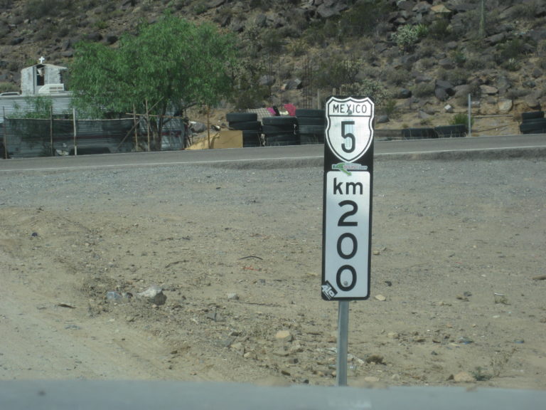
Km. 200 The end of Highway 5 at Laguna Chapala (under construction here). [Now marked as Km. 201]. Highway 5 ends at Laguna Chapala, Highway 1 Km.
233.5.
March 2017:
Just like last month (Feb. 2017), 2016, all of 2015, and back to January 2014, the paved road driving still ends 20.5 kilometers (12.7 miles) south of
the Gonzaga Pemex and that is about 10 miles (10.2) north of [the original] Coco’s Corner and another 12.9 miles to Hwy. 1 for 23 total unpaved
miles. [The highway was completed in February 2020]
The unpaved condition was improved over February in that the rocky 4 miles just south of Coco’s had been scraped over by a grader. It was just less
than an hour from Gonzaga Bay to Highway 1 (Laguna Chapala) in my Tacoma.
Aug. 2, 2017:
The end of pavement was unchanged from 2014, 12.5 miles south of the Gonzaga Pemex, just beyond the Km. 167 post. [In February, 2020, the highway was
completed]
A side note: There was a Km. 170 sign here for a couple years, even though it was 1 km. south of the Km. 166 post. THAT has been fixed to read Km.
167! [A funny thing happened with the completion of the highway: the next kilometer sign (should be 168) was instead Km. 171. Adding three ‘magic’
kilometers to the distance from San Felipe!]
I pass Coco’s Corner, Mile 22.6 from Gonzaga/ 10.1 from the end of pavement, at 8:50 am. I reach Highway 1 (Laguna Chapala) at 9:28 am. Mile 35.7
from Gonzaga, (23.2 unpaved miles). [In April 2021, Coco moved his corner to be next to the highway at Km. 179.5]
May 13, 2019:
In October 2018, flash floods took out several bridges on the new highway, south of Puertecitos. In just over a year, all were repaired the highway
was also completed.
In February 2020, Highway 5 was completed.
Highway 5, from Puertecitos to Highway 1 (77 miles) was built from 2007 to 2020. The land was rugged and there were several delays in the middle of
the grand effort. In 2018, a tropical storm washed out many bridges, as well. The highway makes easy driving of what once took up to 7 hours to drive.
In 2012, it was 48 DIRT miles from Highway One to the new pavement.
In 2013, it was 38 miles on dirt from Chapala (HWY 1) to pavement (just north of Gonzaga).
In 2014, it was 33 miles of unpaved, older road still in use.
In 2015, it was 23 miles to the new pavement.
In 2016, no change from 2015.
In 2018, about a mile on each end of the 23-mile dirt section was paved.
In early 2020, the highway was completed.
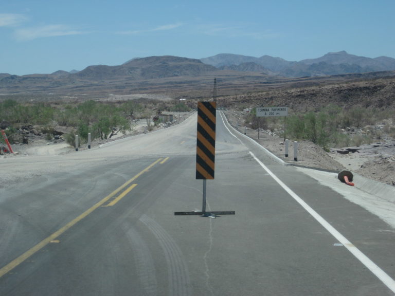
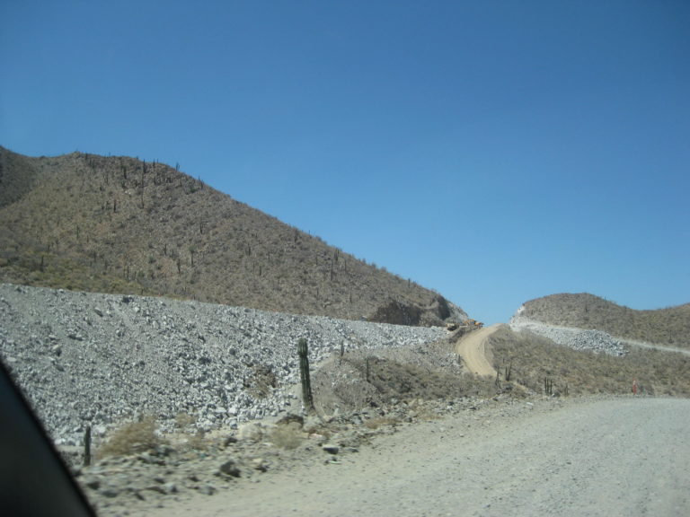
Sept. 2008:

Less than 2 miles from the Puertecitos road, the asphalt ends. Heavy duty construction continues for another few miles. A detour down to the older
route is just ahead.
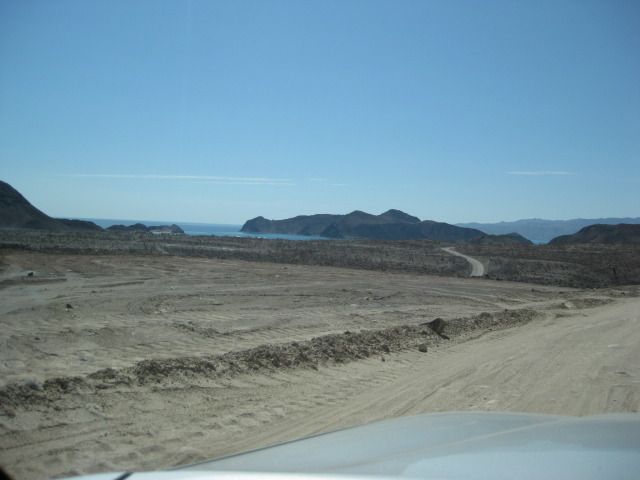
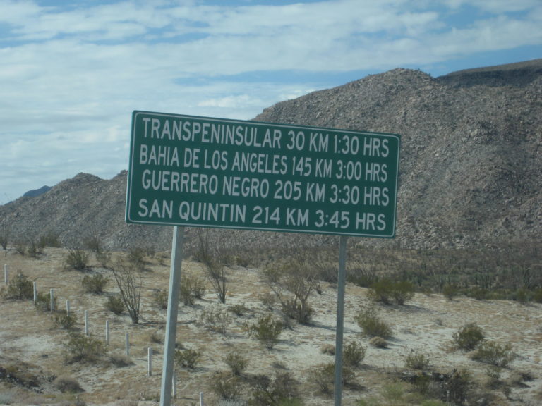
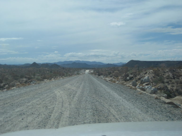
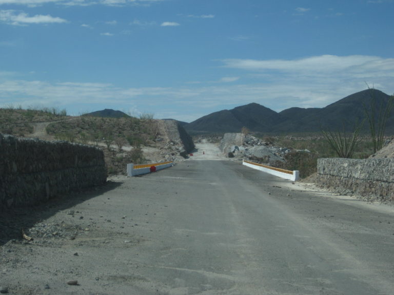
July 2010:

Isla el Huerfanito (The Little Orphan) as seen from Km. 99.
End of the highway this trip!
July 2011:
July 2012:

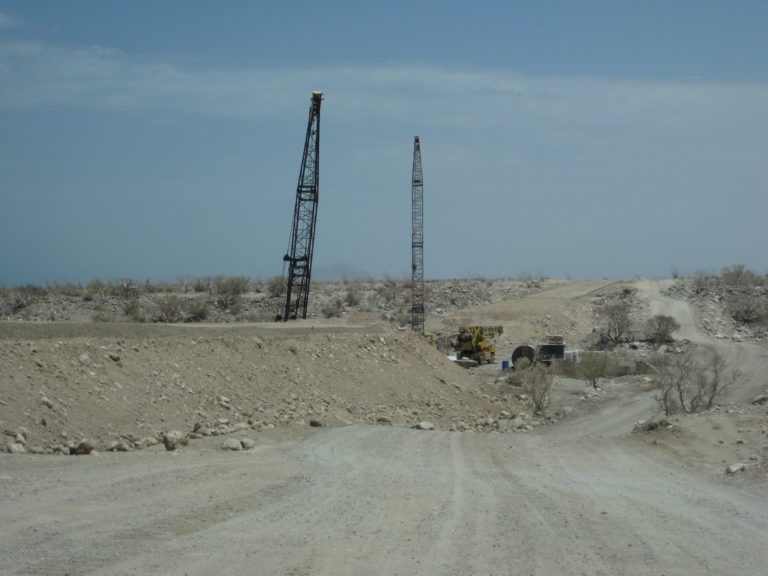
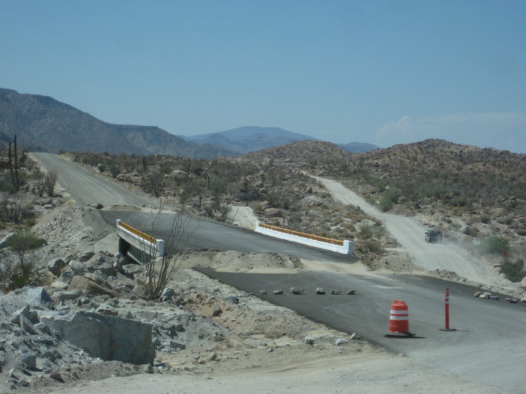
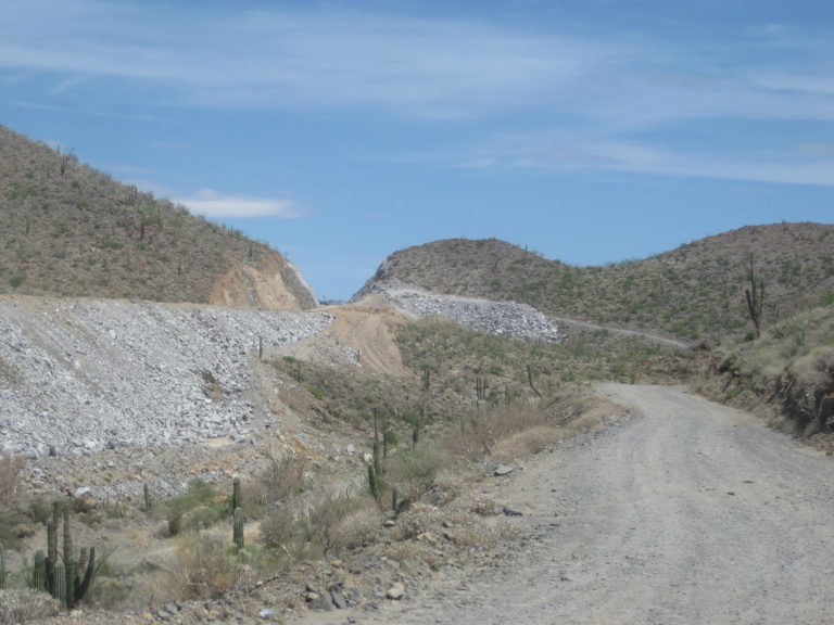
July 2015:

Arroyo Santa María/ Las Arrastras bridge, 5-miles douth of Gonzaga Pemex.

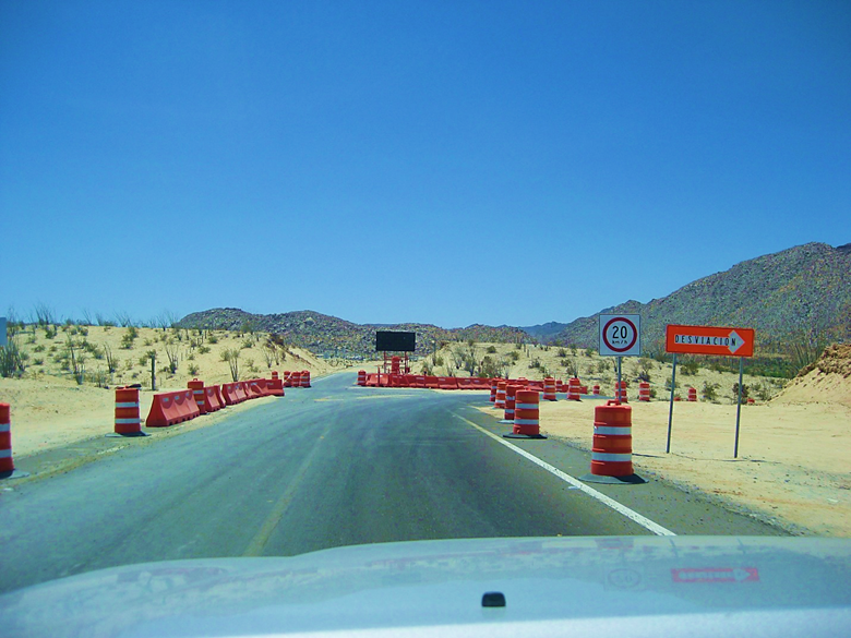
End of pavement, 12.4 miles (20 kms) south of Gonzaga Pemex.
July 2016:
Same as last year location.
Aug. 2017:
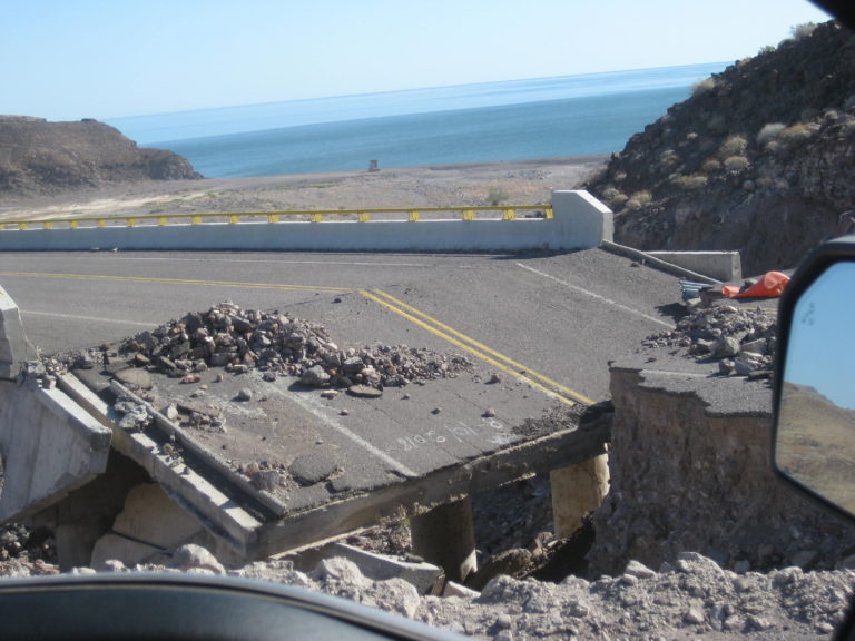
Aug. 2018:
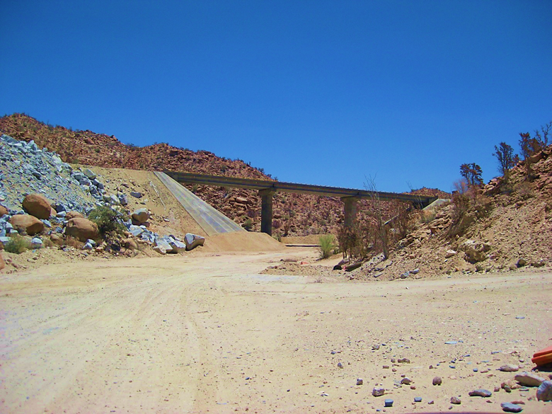
End of Hwy. 5 at Hwy. 1. The kilometer figure has been adjusted to 201 and moved a bit further from the end of the highway.
May 2019:
In October 2018, flash floods took out several bridges on the new highway, south of Puertecitos. In just over a year, all were repaired the highway
was also completed.
Hope you guys enjoyed this!
My maps, post paving:

[Edited on 3-12-2026 by David K]
|
|
|
Tioloco
Elite Nomad
Posts: 6028
Registered: 7-30-2014
Member Is Offline
|
|
Seemed like they were never going to finish that highway. Part of me wishes they hadn't. There were some great remote beaches and desert before the
highway
|
|
|
BeachSeeker
Nomad
Posts: 143
Registered: 6-6-2023
Member Is Offline
|
|
Awesome pictures David. I really wish I had been able to explore Northern Baja back then, when the road stopped at Puertecitos.
We were in San Felipe listening to Sweet Sixx a couple months ago, and they have a pretty good song capturing the changes the road brought, and the
feelings of those who enjoyed the ruggedness before. The AI video is kind of cheesy, but they are a pretty low budget local Baja husband/wife duo.
https://www.youtube.com/watch?v=6Vu0eTOj42k
|
|
|
David K
Honored Nomad
Posts: 65544
Registered: 8-30-2002
Location: San Diego County
Member Is Offline
Mood: Have Baja Fever
|
|
Quote: Originally posted by BeachSeeker  | Awesome pictures David. I really wish I had been able to explore Northern Baja back then, when the road stopped at Puertecitos.
We were in San Felipe listening to Sweet Sixx a couple months ago, and they have a pretty good song capturing the changes the road brought, and the
feelings of those who enjoyed the ruggedness before. The AI video is kind of cheesy, but they are a pretty low budget local Baja husband/wife duo.
https://www.youtube.com/watch?v=6Vu0eTOj42k |
Thanks and that is a pretty cool video!
|
|
|
StuckSucks
Super Nomad
Posts: 2376
Registered: 10-17-2013
Location: Pacific Plate
Member Is Offline
|
|
Video: North on Highway 5 from Highway 1 -- 4/29/2017

|
|
|
David K
Honored Nomad
Posts: 65544
Registered: 8-30-2002
Location: San Diego County
Member Is Offline
Mood: Have Baja Fever
|
|
That was fun to watch! Good music. Coco's Corner got a special bump, too.
|
|
|
|


