| Pages:
1
2 |
mtgoat666
Platinum Nomad

Posts: 21352
Registered: 9-16-2006
Location: San Diego
Member Is Offline
Mood: Hot n spicy
|
|
HURRICANE POLO
000
WTPZ42 KNHC 211453
TCDEP2
Tropical Storm Polo Discussion Number 4
NWS National Hurricane Center Miami FL EP172026
900 AM CST Mon Sep 21 2026
Polo is in the midst of a significant rapid intensification
episode. Satellite images indicate a developing central dense
overcast with very deep convection in the core. Additionally,
microwave images indicate that a small eye has formed beneath the
overcast with hints of a banded eyewall. The initial intensity
is set to 55 kt, consistent with the latest TAFB classification,
and a NOAA Hurricane Hunter aircraft is enroute to provide a better
look at the intensity.
Conditions look ideal for explosive intensification during the next
day or two, with Polo's small inner core over very warm and
untapped waters above 30.5C, within light shear and plentiful
mid-level moisture. Every model responds to these conditions by
showing rapid intensification, and the SHIPS rapid intensification
index is showing percentages as high as I have ever seen them.
The new forecast is raised from the previous one and is very
aggressive, but still below the latest HCCA corrected-consensus
aid, which verbatim would be at least a 99th percentile event for
intensification. Polo is expected to be a small but very dangerous
hurricane by tomorrow and beyond.
The storm is drifting eastward, and still caught in weak steering
currents. A mid-level ridge is expected to develop over Mexico by
late Tuesday, causing Polo to move towards the west-northwest or
northwest by Wednesday into late week. This could bring the core
of the storm near or south of the coast of southwestern Mexico on
Thursday, and then south of the Baja California Peninsula on
Saturday. There is a large north-south spread in the guidance,
which has both short and long-range implications. Generally, the
guidance has nudged southward again, and the NHC forecast is
adjusted in that direction. Given the spread in the track
guidance, this is a low-confidence forecast.
Key Messages:
1. Heavy rainfall associated with Polo will impact coastal portions
of southwest Mexico through Thursday. This rainfall may produce
life-threatening flooding and mudslides, especially in areas of
steep terrain.
2. Polo is forecast to strengthen to a major hurricane while it
moves closer to the coast of southwestern Mexico during the next few
days. Although the core of the hurricane is forecast to stay
offshore, it is too soon to determine the exact location or
magnitude of impacts. Residents in southwestern Mexico should
closely monitor its progress and updates to the forecast. A Tropical
Storm Watch is in effect for portions of southwestern Mexico.
[Edited on 9-21-2026 by mtgoat666]
Woke!
Hands off!
“Por el bien de todos, primero los pobres.”
“...ask not what your country can do for you – ask what you can do for your country.” “My fellow citizens of the world: ask not what America
will do for you, but what together we can do for the freedom of man.”
Pronoun: the royal we
|
|
|
mtgoat666
Platinum Nomad
Posts: 21352
Registered: 9-16-2006
Location: San Diego
Member Is Offline
Mood: Hot n spicy
|
|
still too early to determine what track it will take relative to baja peninsula. but looks like it is coming...
Woke!
Hands off!
“Por el bien de todos, primero los pobres.”
“...ask not what your country can do for you – ask what you can do for your country.” “My fellow citizens of the world: ask not what America
will do for you, but what together we can do for the freedom of man.”
Pronoun: the royal we
|
|
|
Lee
Ultra Nomad
Posts: 3641
Registered: 10-2-2006
Location: High in the Colorado Rockies
Member Is Offline
|
|
140mph wind this Saturday and close to Cabo. Don't want to be there.
US Marines: providing enemies of America an opportunity to die for their country since 1775.
What I say before any important decision.
F*ck it.
|
|
|
JDCanuck
Ultra Nomad
Posts: 2796
Registered: 2-22-2020
Member Is Offline
|
|
At least this time there are a few days to prepare with advance warning.
|
|
|
AKgringo
Elite Nomad
Posts: 6422
Registered: 9-20-2014
Location: Anchorage, AK (no mas!)
Member Is Offline
Mood: Retireded
|
|
Forecasters this year must be losing sleep and fighting ulcers. We always expect the predictions to be a bit different than reality a week later, but
this year the corrections seem to be more frequent and greater than in years past!
If you are not living on the edge, you are taking up too much space!
"Could do better if he tried!" Report card comments from most of my grade school teachers. Sadly, still true!
|
|
|
Ateo
Elite Nomad
Posts: 5980
Registered: 7-18-2011
Member Is Offline
|
|
East Cape surf spot alert!!! Heck I may head to La Ribera.
|
|
|
Don Jorge
Senior Nomad
Posts: 692
Registered: 8-29-2003
Member Is Offline
|
|
Major Polo Cat 5
6:00 AM CST Tue Sep 22
Location: 14.5°N 101.5°W
Moving: E at 6 mph
Min pressure: 926 mb
Max sustained: 160 mph
What can you say? This one picked up 90 mph in intensity in 24 hours.
Guidance is vague after 120 hours. Waiting.
�And it never failed that during the dry years the people forgot about the rich years, and during the wet years they lost all memory of the dry
years. It was always that way.�― John Steinbeck
"Until a person learns to respect nature and talk to the animal world, he will never know his true role on Earth." Enzo Mallorca
"Nature bats last." Doug "Hayduke" Peac-ck
|
|
|
StuckSucks
Super Nomad
Posts: 2382
Registered: 10-17-2013
Location: Pacific Plate
Member Is Offline
|
|
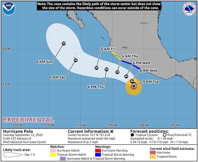
|
|
|
mtgoat666
Platinum Nomad
Posts: 21352
Registered: 9-16-2006
Location: San Diego
Member Is Offline
Mood: Hot n spicy
|
|
Not shown on the 5-d forecast track is that around day 5+ the track is expected to turn northward (per NOAA NHC), which may bring the storm onshore on
the pac coast of BCS…
Woke!
Hands off!
“Por el bien de todos, primero los pobres.”
“...ask not what your country can do for you – ask what you can do for your country.” “My fellow citizens of the world: ask not what America
will do for you, but what together we can do for the freedom of man.”
Pronoun: the royal we
|
|
|
David K
Honored Nomad
Posts: 65634
Registered: 8-30-2002
Location: San Diego County
Member Is Offline
Mood: Have Baja Fever
|
|
What does the M stand for at the hurricane eye locations?
|
|
|
AKgringo
Elite Nomad
Posts: 6422
Registered: 9-20-2014
Location: Anchorage, AK (no mas!)
Member Is Offline
Mood: Retireded
|
|
Maybe?
If you are not living on the edge, you are taking up too much space!
"Could do better if he tried!" Report card comments from most of my grade school teachers. Sadly, still true!
|
|
|
mtgoat666
Platinum Nomad
Posts: 21352
Registered: 9-16-2006
Location: San Diego
Member Is Offline
Mood: Hot n spicy
|
|
M = major. Over 110 mph, categories 3, 4 and 5
track the storm here:
https://www.cyclocane.com/polo-storm-tracker/
and
https://www.nhc.noaa.gov/
[Edited on 9-22-2026 by mtgoat666]
Woke!
Hands off!
“Por el bien de todos, primero los pobres.”
“...ask not what your country can do for you – ask what you can do for your country.” “My fellow citizens of the world: ask not what America
will do for you, but what together we can do for the freedom of man.”
Pronoun: the royal we
|
|
|
David K
Honored Nomad
Posts: 65634
Registered: 8-30-2002
Location: San Diego County
Member Is Offline
Mood: Have Baja Fever
|
|
Cool!  
Thanks... Knowledge is good
|
|
|
Don Jorge
Senior Nomad
Posts: 692
Registered: 8-29-2003
Member Is Offline
|
|
Another brewing
Looking more and more like another named storm is developing in the Gulf of Tehuantepec on the heels of Polo.
Polo is forecast to move north northwest. Tropical storm Odalys is forecast to move north northeast. Around Sunday they will be close enough
together to perhaps change the models. Maybe?
It is pretty fascinating watching the imagery from NHC NOAA in this unprecedented El Niño moment.
Olive Ridley turtles laid eggs on Huntington Beach sands this week, this year. First time ever been recorded as happening. This fall and winter are
going to be full of subtropical surprises for Baja and So Cal. Yikes!
�And it never failed that during the dry years the people forgot about the rich years, and during the wet years they lost all memory of the dry
years. It was always that way.�― John Steinbeck
"Until a person learns to respect nature and talk to the animal world, he will never know his true role on Earth." Enzo Mallorca
"Nature bats last." Doug "Hayduke" Peac-ck
|
|
|
AKgringo
Elite Nomad
Posts: 6422
Registered: 9-20-2014
Location: Anchorage, AK (no mas!)
Member Is Offline
Mood: Retireded
|
|
My prediction.....
The dessert will bloom! I just can't tell you where and when it will max out.
If you are not living on the edge, you are taking up too much space!
"Could do better if he tried!" Report card comments from most of my grade school teachers. Sadly, still true!
|
|
|
David K
Honored Nomad
Posts: 65634
Registered: 8-30-2002
Location: San Diego County
Member Is Offline
Mood: Have Baja Fever
|
|
That would be "sweet"!
|
|
|
SFandH
Elite Nomad
Posts: 7666
Registered: 8-5-2011
Member Is Offline
|
|
I love blooming desserts, especially after a nice meal.
Sorry AK, I made the same spelling error in school. 
|
|
|
lencho
Junior Nomad
Posts: 91
Registered: 1-16-2005
Location: Tan lejos de Dios y tan cerca de EU
Member Is Offline
Mood: Somnoliento
|
|
Sonoran Dessert: Churros rellenos de
chocolate coca.
"I can normally tell how intelligent a man is, by how stupid he thinks I
am."
"...they were careful of their demeanor that they not be thought to have opinions on what they heard for like most men skilled at their work they
were scornful of any least suggestion of knowing anything not learned at first hand."
Cormac McCarthy, All the Pretty Horses
"Be kind, be patient, help others." -- Isabel Allende
"My gas stove identifies as electric." Anonymous

|
|
|
AKgringo
Elite Nomad
Posts: 6422
Registered: 9-20-2014
Location: Anchorage, AK (no mas!)
Member Is Offline
Mood: Retireded
|
|
Quote: Originally posted by SFandH  |
I love blooming desserts, especially after a nice meal.
Sorry AK, I made the same spelling error in school. |
My teachers were right! I could have done better if I tried! I think I have some Flan in the refrigerator that is about to bloom.
If you are not living on the edge, you are taking up too much space!
"Could do better if he tried!" Report card comments from most of my grade school teachers. Sadly, still true!
|
|
|
mtgoat666
Platinum Nomad
Posts: 21352
Registered: 9-16-2006
Location: San Diego
Member Is Offline
Mood: Hot n spicy
|
|

Hurricane Polo Discussion Number 12
NWS National Hurricane Center Miami FL EP172026
900 AM CST Wed Sep 23 2026
Satellite imagery this morning indicates that Polo is continuing to
undergo an eyewall replacement cycle, with infrared imagery showing
multiple rings of cold tops near and around the center. Overall,
the hurricane is not as intense as it was 24 h ago, as the eye has
become less distinct and the eyewall cloud tops have warmed. The
various satellite intensity estimates have trended downward, and
based on this trend the initial intensity is lowered to a possibly
generous 130 kt. Outer rainbands in the northeastern semicircle
have reached the coast of Mexico.
Polo is starting its forecast turn toward the northwest with the
initial motion now 325/4 kt. Water vapor imagery suggests a
mid-level ridge is building over Texas and Mexico, and the
dynamical models forecast this ridge to build westward to the north
of Polo for the next 2-3 days. This evolution should result in Polo
moving northwestward and then west-northwestward with some increase
in forward speed. The forecast becomes more uncertain after 60-72
h. The dynamical models forecast the ridge to the north to weaken
around that time as a mid-latitude trough moves into the western
United States. There is also the possibility of interaction with
Hurricane Odalys to the west. The guidance becomes divergent by
120 h, with the GFS/HCCA/Google DeepMind/Florida State
Superensemble showing a northward motion close to Baja California,
while the regional hurricane models/UKMET/Canadian show a
northwestward motion farther away from Baja. The track forecast
goes with the northward motion scenario, but there is a significant
amount of uncertainty in this portion of the forecast.
The trends of the intensity forecast guidance suggest that Polo
could weaken a little during the next day or so, followed by
re-intensification during the ensuing 24 h. The first two days of
the intensity forecast follow these trends, and there could be
fluctuations in intensity due to eyewall replacement cycles
superimposed on top of this overall trend. After 48 h, the
environment gradually becomes less favorable due to slightly
stronger shear and the possibility of some dry air entrainment. The
guidance forecast slow weakening during this time, and the new
intensity forecast follows suit. The new forecast is near the upper
edge of the guidance for the first 60 h and then lies closer to the
middle of the guidance envelope.
[Edited on 9-23-2026 by mtgoat666]
Woke!
Hands off!
“Por el bien de todos, primero los pobres.”
“...ask not what your country can do for you – ask what you can do for your country.” “My fellow citizens of the world: ask not what America
will do for you, but what together we can do for the freedom of man.”
Pronoun: the royal we
|
|
|
| Pages:
1
2 |





![[*]](images/xmbforum/default_icon.gif)