| Pages:
1
2 |
surfdog
Junior Nomad

Posts: 38
Registered: 11-9-2006
Location: Not where I want to be...
Member Is Offline
Mood: Ready to go...
|
|
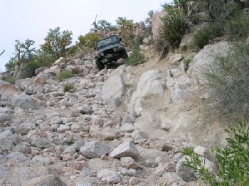
Road Condition Scale and Seven Sisters
Now that I have some experience in Baja off-road driving I was wondering if there is a scale used to measure off-road conditions. The reason I ask
is that it would be very handy to know how roads compare to each other.
I just completed the road through Gonzaga from Hwy 1 to Puertecitos. The first section from Hwy 1 to Gonzaga was fairly easy and could be done
without 4 wheel drive. The second section was much more demanding and required good ground clearance. It could probably be done without 4 wheel
drive unless you got hung up.
Is there a scale or could we come up with one to grade the roads?
How do the roads down to the beach (seven sisters area) along the Pacific between El Rosario and Guerrero Negro compare to the road from Hwy 1 to
Puertecitos? This is where we are planning our next trip. I would expect they are more sand than rocks and require 4x4 for this reason.
Thanks
|
|
|
David K
Honored Nomad
Posts: 65545
Registered: 8-30-2002
Location: San Diego County
Member Is Offline
Mood: Have Baja Fever
|
|
Highway 1 to Puertecitos is a graded/ engineered dirt highway.. It was built in 1985 to replace the 4WD trail that was made in the late 1950's by
Arturo Grosso. It was supposed to get paved, of course. The reason it is so 'bad' is that they don't maintain it... by replacing the top layer of
smooth dirt after rains wash it away and regular use and Baja 1000 traffic spins away the dirt and exposed the base rock roadbed.
In Jim Hunter's excellent book Offbeat Baja c1977, he had a road classification system that was pretty cool. The road into Mision Santa Maria has some
Class 10 (avoid if possible) sections... I have driven over with a smile on my face!
[Edited on 2-21-2007 by David K]
|
|
|
Taco de Baja
Super Nomad
Posts: 1913
Registered: 4-14-2004
Location: Behind the Orange Curtain, CA
Member Is Offline
Mood: Dreamin' of Baja
|
|
The road to 7 sisters is also a Class 10.... 
|
|
|
4baja
Super Nomad
Posts: 1339
Registered: 9-4-2003
Location: morro bay ca
Member Is Offline
|
|
yea right taco

|
|
|
surfdog
Junior Nomad
Posts: 38
Registered: 11-9-2006
Location: Not where I want to be...
Member Is Offline
Mood: Ready to go...
|
|
Ok, this looks a little scary!
Are there any reasonably easy access points to good surfing beaches between El Rosario and Guerrero Negro? I have purchase Surf Maps to Baja and it
doesn't mention anything this tuff.
|
|
|
David K
Honored Nomad
Posts: 65545
Registered: 8-30-2002
Location: San Diego County
Member Is Offline
Mood: Have Baja Fever
|
|
Do you have the Baja Almanac or even the AAA Baja Map?
Get the AAA Baja map as it shows the main dirt roads in the Seven Sisiters area...
Signed access roads off Hwy. 1 for Santa Catarina/Punta Conoas, Faro San Jose, Santa Rosalillita (paved to the coast then a graded road north to
Diablo and other points).
|
|
|
surfer jim
Super Nomad
Posts: 1891
Registered: 8-29-2003
Location: high desert
Member Is Offline
|
|
If you start at the south end of the sisters area (santa rosalillita) the road is passable by "any" vehicle for the next 30 or so miles.....further
north the road will be rougher and less traveled.....(haven't been there myself).....
the deal....go with 2 vehicles....start from south end and see how far you can go.....
What do you drive?
|
|
|
surfdog
Junior Nomad
Posts: 38
Registered: 11-9-2006
Location: Not where I want to be...
Member Is Offline
Mood: Ready to go...
|
|
I do have the AAA map. I haven't been able to get my hands on an Baja Almanac yet.
Are there any good surf spots within a short drive to a decent Hotel or are they all camp only?
|
|
|
surfdog
Junior Nomad
Posts: 38
Registered: 11-9-2006
Location: Not where I want to be...
Member Is Offline
Mood: Ready to go...
|
|
surfer jim,
Currently have a 2wd Yukon. I am looking to get a Chevy Avalanche 4x4 next year. Got to use that GM discount (my mother in law is a retiree)
|
|
|
baitcast
Super Nomad
Posts: 1785
Registered: 8-31-2003
Location: kingman AZ.
Member Is Offline
Mood: good
|
|
Punta San Carlos Is south of El Rosario 30 or 40 miles as the crow flys,a wind surfing camp has been set up there also big surf at times in the
year,decent road in.
The halibut and WSB fishing is first rate also.
BAITCAST
|
|
|
David K
Honored Nomad
Posts: 65545
Registered: 8-30-2002
Location: San Diego County
Member Is Offline
Mood: Have Baja Fever
|
|
| Quote: | Originally posted by surfdog
I do have the AAA map. I haven't been able to get my hands on an Baja Almanac yet.
Are there any good surf spots within a short drive to a decent Hotel or are they all camp only? |
The Almanac is out of print (again) as Landon is working on a revised edition...
The AAA map will do fine. Do you see Santa Rosalillita and the road going to it from Hwy. 1, north of Rosarito?
That road is paved now and the graded road is shown going north 14.2 miles to near Punta Prieta (not the town on Hwy. 1, but the point on the
coast)... A road continues north past Punta Lobos, Punta Maria and to Punta Cono. Punta Diablo is between Lobos and Maria... the little bump in the
coast near the 'a' in Bahia (Bahia Maria) on the map.
|
|
|
David K
Honored Nomad
Posts: 65545
Registered: 8-30-2002
Location: San Diego County
Member Is Offline
Mood: Have Baja Fever
|
|
| Quote: | Originally posted by baitcast
Punta San Carlos Is south of El Rosario 30 or 40 miles as the crow flys,a wind surfing camp has been set up there also big surf at times in the
year,decent road in.
The halibut and WSB fishing is first rate also.
BAITCAST |
>>> See http://www.solosports.net the Punta San Carlos web site
[Edited on 2-22-2007 by David K]
|
|
|
surfdog
Junior Nomad
Posts: 38
Registered: 11-9-2006
Location: Not where I want to be...
Member Is Offline
Mood: Ready to go...
|
|
| Quote: | Originally posted by David K
The AAA map will do fine. Do you see Santa Rosalillita and the road going to it from Hwy. 1, north of Rosarito? |
I see it on the map. We were originally planning on hitting this road but plans change. This will be our next adventure.
Is there anywhere to stay in the area or is camping only?
|
|
|
Taco de Baja
Super Nomad
Posts: 1913
Registered: 4-14-2004
Location: Behind the Orange Curtain, CA
Member Is Offline
Mood: Dreamin' of Baja
|
|
| Quote: | Originally posted by surfdog
I do have the AAA map. I haven't been able to get my hands on an Baja Almanac yet.
Are there any good surf spots within a short drive to a decent Hotel or are they all camp only? |
No hotels (yet), camping only. But that is the joy of Baja. Spend all day getting there, then crack a cold one with the buddies who came along with
you and enjoy the solitude with the only sounds being crashing waves.
|
|
|
woody with a view
PITA Nomad
Posts: 15940
Registered: 11-8-2004
Location: Looking at the Coronado Islands
Member Is Offline
Mood: Everchangin'
|
|
| Quote: |
enjoy the solitude with the only sounds being crashing waves.
|
and, of course, the coyotes.
|
|
|
Slowmad
Nomad
Posts: 243
Registered: 3-24-2005
Location: Alta California
Member Is Offline
|
|
The guys who lost the 4Runner in the picture were run off the road and attacked with machetes. One made it to the highway after a two day hike. The
other stumbled into a local rancher's house bloody and scared for his life. The vehicle was stripped to the bones within 24 hours by the meth-addled
piratas two points north.
There is more sketchy behavior on that coast than anywhere else in Baja.
Especially on the roads noted by David K.
|
|
|
woody with a view
PITA Nomad
Posts: 15940
Registered: 11-8-2004
Location: Looking at the Coronado Islands
Member Is Offline
Mood: Everchangin'
|
|
| Quote: |
There is more sketchy behavior on that coast than anywhere else in Baja.
|
especially those midnight planes landing on the low tide-hard pack without lights, and the boats coming to meet them.....when you here a plane, douse
your campfire, pronto
|
|
|
woody with a view
PITA Nomad
Posts: 15940
Registered: 11-8-2004
Location: Looking at the Coronado Islands
Member Is Offline
Mood: Everchangin'
|
|
as to the scale......
1=pavement
5=blurred vision from the rut
10= OHMYGAWD
hope this helps
|
|
|
bajaandy
Senior Nomad
Posts: 769
Registered: 2-7-2004
Location: North County
Member Is Offline
Mood: Adventurous
|
|
| Quote: | Originally posted by Slowmad
The vehicle was stripped to the bones within 24 hours by the meth-addled piratas two points north.
|
Hmmmmm..... that's not quite the way I remember it. That vehicle was still there weeks after it got stranded on the beach. Yes, some of the things
had been taken off of it, but as I recall only the wheels and the intake were missing. In fact, I think it was still locked when I saw it.
But keep those rumors flying!
Surfdog... I did the entire seven sisters run in two wheel drive. Yes, I have a big 4x4, but I never even locked the hubs. But that was only on one
trip. The time before that I had to lock up just to get across the salt flats and back bays. Ya just never know. You want a real adventure? Go it
alone and hope for the best. Otherwise, follow the advice given and go with two vehicles.
That really is a very beautiful stretch of coast... very rugged and very remote.
Oh yeah, before I forget, make sure you get permission from the Sacred Saints of the Secret Spots before you go.
And make sure you post a trip report when you get back.
subvert the dominant paradigm
"If you travel with a man, you must either fall out with him or make him your good friend."
JBL Noel
|
|
|
Sonora Wind
Nomad
Posts: 228
Registered: 9-25-2003
Member Is Offline
|
|
Yesss
Was the third or fourth best trip I ever took to the long and lonely land. Drove in two wheel with an 8.5 Lance Lite. Had a blast. WSB and pismos by
the bucket. Then two unexpected days of rain. Due to lack of T Mobile coverage, tow trucks, and a top notch road construction crew I was unable to
return to work on time. Had a blast!!! Take the Standard Emergency Precausions, and you'll do fine.
|
|
|
| Pages:
1
2 |