David K
Honored Nomad

Posts: 65570
Registered: 8-30-2002
Location: San Diego County
Member Is Offline
Mood: Have Baja Fever
|
|
FLY OVER BAJA FROM YOUR PC (Satellite Views)
Taken from an earlier thread 'Baja Locations from Space' I will re-post the links to the Google Map satellite images of various Baja locations. From
the link, you can zoom in/ out and fly around over an area by sliding your mouse or using the arrows provided.
Since I did this work, I have found easier to use and full screen http://www.wikimapia.org I have been locating mission sites and the Camino Real there...
Just zoom in on Baja and fly around!
Here are the Google links to Baja places... After clicking the link, click to enlarge the image (full screen)... Then you can enlarge the image even
more by placing the mouse on the left top of the image and click to enlarge to the left.
PACIFIC COAST:
La Bufadora, Punta Banda
Punta Cabras
Punta Colonet
Bahia San Quintin
Punta Baja
Punta San Carlos
Punta Canoas
Punta Vibora
Punta Blanco
Punta Cono
Punta Maria
Escalera Nautica at Santa Rosalillita]
El Tomatal & Miller's Landing
Morro Santo Domingo & Laguna Manuela
Laguna Guerrero Negro (Black Warrior)
Laguna Ojo de Liebre (Scammon's Lagoon)
Bahia Tortugas
San Roque
Bahia Asuncion
Punta Abreojos
San Juanico/ Scorpion Bay
Puerto Lopez Mateos, Mag Bay
Puerto San Carlos, Mag Bay
Puerto Cancun, Mag Bay
Punta Conejo
Cabo San Lucas
GULF COAST:
San Felipe
Punta Estrella
Rancho/Laguna Percebu & north end of Shell Island
Bahia Santa Maria, south of San Felipe
El Coloradito
Punta San Fermin
Puertecitos
Isla El Huerfanito (The Little Orphan) and Nacho's Camp
Gonzaga Bay (Punta Willard to Punta Final)
Puerto Calamajue
End of new track to coast (so. of Calamajue)
Punta Remedios, Bahia Guadalupe
Bahia de los Angeles
Punta San Francisquito
La Trinidad
Santa Rosalia
Mulege
Santispac to Coyote, Bahia Concepcion
El Requeson, Bahia Concepcion
Loreto
Puerto Escondido
Agua Verde
Timbabichi
Los Burros and Valle Kakiwi lake
San Evaristo, Valle el Venado lake, Isla San Jose's Punta San Ysidro
San Juan de la Costa
El Magote, Ensenada de Aripes, El Centenario, part of La Paz
Pichilingue (ferry terminal)
Las Arenas, Ensenada de los Muertos
Los Barriles
La Ribera
Cabo Pulmo and Los Frailes
Estero San Jose, San Jose del Cabo
New harbor
See Pacific Coast list for Cabo San Lucas
ALONG HIGHWAY ONE (within 6 miles):
Tijuana Border Crossing
Popotla (Fox Studios to Punta el Descanso)
San Pedro Martir/ Observatory Road Jcn.
San Telmo de Arriba (on Observatory road)
Turnoff to Punta San Carlos (Km. 80-81)
Rancho El Arenoso (abnd.)
Mision San Fernando access at Hwy. 1
El Progreso (on Hwy. 1), signed access to San Fernando
Mision San Fernando
San Agustin (Abdn. Pemex, trailer park)
El Marmol Road at Hwy. 1 (next to Cafe Sonora)
Arroyo Agua Dulce & 1973 water truck access road at Hwy. 1
Agua Dulce (historic spring on El Camino Real)
New/good access to Agua Dulce
Old Southern road to/from El Marmol at Old Main Baja Road
Agua Escondida access (?) at old Baja road
Faro San Jose Road at Hwy. 1
Catavina Rock Art Site (near Hwy. 1 at north arroyo crossing)
Catavina
Laguna Chapala
Turnoff to San Antonio & Pacific Coast
El Crucero (old San Felipe & Gonzaga road jcn. with Mex. 1)
Old L.A. Bay Road crossing Hwy. 1, New Rancho San Luis road jcn.
Shortcut road to San Antonio (Codornices) at Hwy. 1
L.A. Bay Hwy. Jcn. (ex-Parador Punta Prieta)
Punta Prieta (old dirt strip upper left & paved runway lower right)
Turnoff to Santa Roaslillita & paved part of Escalera Nautica highway
(Nuevo) Rosarito, road east to San Borja
Turnoff to El Tomatal
Villa Jesus Maria, road to Laguna Manuela
Eagle Monument, Guerrero Negro
Turnoff to El Arco
Turnoff to Guillermo Prieto, Mision Santa Gertrudis, Punta San Francisquito
Vizcaino, Turnoff to Bahia Tortugas
Turnoff to San Francisco de la Sierra
Turnoff to Punta Abreojos
San Ignacio
San Bartolo
Santiago
Agua Caliente (near Santiago)
Miraflores
MISC. BAJA LOCATIONS (not covered above):
Tijuana/Tecate Toll Gate & Blvd. 2000 Jcn.
Tecate Border Crossing
Laguna Salada Road at Mexico #2
Guadalupe Canyon
Colorado River (near gulf)
Ojos Negros
Laguna Hanson
Mike's Sky Rancho Jcn., Hwy. 3
San Matias Pass, Hwy. 3
Crucero La Trinidad (Hwy. 5 & Hwy. 3 Jcn.)
Mike's Sky Rancho
Meling Ranch
Observatorio
Diablo Mountain & Canyon
San Isidoro
Trail to San Pedro Martir from San Isidoro
Mision San Pedro Martir
San Felipe Airport
Sulfur Mine (El Apache)
Agua Caliente Canyon (off Valle Chico)
Agua Caliente Hot Spring
Rancho el Matomi (west of Puertecitos)
Mine west of Puertecitos, at end of long road from Mex. 1
Rancho San Antonio
El Marmol (onyx school house)
El Volcan
Peninsular Divide, Mision Santa Maria Road
Las Arrastras (site)
Pioneer Mine
Coco's Corner
Calamajue Mission Site
Tinaja de Yubay
El Toro Copper Mine
Mision San Borja
El Camino Real switchback
Las Flores Railroad, south end
Rancho La Bocana, south of L.A. Bay (called 'San Pedro' in Almanac)
El Arco
Guillermo Prieto (north of Vizcaino)
Geothermal Plant N of Santa Rosalia
Todos Santos
[Edited on 10-10-2008 by David K]
|
|
|
capt. mike
Elite Nomad
Posts: 8085
Registered: 11-26-2002
Location: Bat Cave
Member Is Offline
Mood: Sling time!
|
|
here's one i took myself after i lighted the JATOs once.
almost blew lunch tho.

formerly Ordained in Rev. Ewing\'s Church by Mail - busted on tax fraud.......
Now joined L. Ron Hoover\'s church of Appliantology
\"Remember there is a big difference between kneeling down and bending over....\"
www.facebook.com/michael.l.goering |
|
|
toneart
Ultra Nomad
Posts: 4901
Registered: 7-23-2006
Member Is Offline
Mood: Skeptical
|
|
Hey DK! Did you need your passport to do all that high altitude flying?
|
|
|
Howard
Super Nomad
Posts: 2353
Registered: 11-13-2007
Location: Loreto/Manhattan Beach/Kona
Member Is Offline
Mood: I'd rather regret the things I've done than regret the things I haven't done.
|
|
Thank you for putting in the time to do this but I can speak for the picture from Loreto and the image is from many years ago. Is it that old for the
other locations in Baja?
|
|
|
BMG
Super Nomad
Posts: 1776
Registered: 6-10-2007
Location: La Paz / Bahia Asunci�n / Away from home
Member Is Offline
|
|
| Quote: | Originally posted by Howard
Thank you for putting in the time to do this but I can speak for the picture from Loreto and the image is from many years ago. Is it that old for the
other locations in Baja? |
The current Google photo of our house in La Paz is at least 2 years old. The photo of our boat in Alameda, CA is only a year or so old. The photo of
our business in Sedona, AZ is about 4-5 years old. Ana's sister's house in Port Townsend, WA isn't in the Google photo so that photo is at least 4
years old too.
GeoEye-1, the world's highest resolution commercial satellite is now taking photos and is sponsored by Google. I don't know when we can expect to see
Baja updated.
I think the world is run by C- students.
|
|
|
David K
Honored Nomad
Posts: 65570
Registered: 8-30-2002
Location: San Diego County
Member Is Offline
Mood: Have Baja Fever
|
|
Each time I go back to the images, I see new or high resolution additions that were not there before... The best part of the high resolution photos is
following dirt roads and trails... You can get the GPS waypoint from the image, then find it on your next trip.
|
|
|
Udo
Elite Nomad
Posts: 6364
Registered: 4-26-2008
Location: Black Hills, SD/Ensenada/San Felipe
Member Is Offline
Mood: TEQUILA!
|
|
| Quote: | Originally posted by David K
Taken from an earlier thread 'Baja Locations from Space' I will re-post the links to the Google Map satellite images of various Baja locations. From
the link, you can zoom in/ out and fly around over an area by sliding your mouse or using the arrows provided.
Since I did this work, I have found easier to use and full screen http://www.wikimapia.org I have been locating mission sites and the Camino Real there...
Just zoom in on Baja and fly around!
Here are the Google links to Baja places... After clicking the link, click to enlarge the image (full screen)... Then you can enlarge the image even
more by placing the mouse on the left top of the image and click to enlarge to the left.
| Quote: | Hey David!
Thanks for posting the links...however, you know I am somewhat technologically (phew!) challenged. How do I save the links on my own GOOGLE maps page?
Thanks
Udo |
PACIFIC COAST:
La Bufadora, Punta Banda
Punta Cabras
Punta Colonet
Bahia San Quintin
Punta Baja
Punta San Carlos
Punta Canoas
Punta Vibora
Punta Blanco
Punta Cono
Punta Maria
Escalera Nautica at Santa Rosalillita]
El Tomatal & Miller's Landing
Morro Santo Domingo & Laguna Manuela
Laguna Guerrero Negro (Black Warrior)
Laguna Ojo de Liebre (Scammon's Lagoon)
Bahia Tortugas
San Roque
Bahia Asuncion
Punta Abreojos
San Juanico/ Scorpion Bay
Puerto Lopez Mateos, Mag Bay
Puerto San Carlos, Mag Bay
Puerto Cancun, Mag Bay
Punta Conejo
Cabo San Lucas
GULF COAST:
San Felipe
Punta Estrella
Rancho/Laguna Percebu & north end of Shell Island
Bahia Santa Maria, south of San Felipe
El Coloradito
Punta San Fermin
Puertecitos
Isla El Huerfanito (The Little Orphan) and Nacho's Camp
Gonzaga Bay (Punta Willard to Punta Final)
Puerto Calamajue
End of new track to coast (so. of Calamajue)
Punta Remedios, Bahia Guadalupe
Bahia de los Angeles
Punta San Francisquito
La Trinidad
Santa Rosalia
Mulege
Santispac to Coyote, Bahia Concepcion
El Requeson, Bahia Concepcion
Loreto
Puerto Escondido
Agua Verde
Timbabichi
Los Burros and Valle Kakiwi lake
San Evaristo, Valle el Venado lake, Isla San Jose's Punta San Ysidro
San Juan de la Costa
El Magote, Ensenada de Aripes, El Centenario, part of La Paz
Pichilingue (ferry terminal)
Las Arenas, Ensenada de los Muertos
Los Barriles
La Ribera
Cabo Pulmo and Los Frailes
Estero San Jose, San Jose del Cabo
New harbor
See Pacific Coast list for Cabo San Lucas
ALONG HIGHWAY ONE (within 6 miles):
Tijuana Border Crossing
Popotla (Fox Studios to Punta el Descanso)
San Pedro Martir/ Observatory Road Jcn.
San Telmo de Arriba (on Observatory road)
Turnoff to Punta San Carlos (Km. 80-81)
Rancho El Arenoso (abnd.)
Mision San Fernando access at Hwy. 1
El Progreso (on Hwy. 1), signed access to San Fernando
Mision San Fernando
San Agustin (Abdn. Pemex, trailer park)
El Marmol Road at Hwy. 1 (next to Cafe Sonora)
Arroyo Agua Dulce & 1973 water truck access road at Hwy. 1
Agua Dulce (historic spring on El Camino Real)
New/good access to Agua Dulce
Old Southern road to/from El Marmol at Old Main Baja Road
Agua Escondida access (?) at old Baja road
Faro San Jose Road at Hwy. 1
Catavina Rock Art Site (near Hwy. 1 at north arroyo crossing)
Catavina
Laguna Chapala
Turnoff to San Antonio & Pacific Coast
El Crucero (old San Felipe & Gonzaga road jcn. with Mex. 1)
Old L.A. Bay Road crossing Hwy. 1, New Rancho San Luis road jcn.
Shortcut road to San Antonio (Codornices) at Hwy. 1
L.A. Bay Hwy. Jcn. (ex-Parador Punta Prieta)
Punta Prieta (old dirt strip upper left & paved runway lower right)
Turnoff to Santa Roaslillita & paved part of Escalera Nautica highway
(Nuevo) Rosarito, road east to San Borja
Turnoff to El Tomatal
Villa Jesus Maria, road to Laguna Manuela
Eagle Monument, Guerrero Negro
Turnoff to El Arco
Turnoff to Guillermo Prieto, Mision Santa Gertrudis, Punta San Francisquito
Vizcaino, Turnoff to Bahia Tortugas
Turnoff to San Francisco de la Sierra
Turnoff to Punta Abreojos
San Ignacio
San Bartolo
Santiago
Agua Caliente (near Santiago)
Miraflores
MISC. BAJA LOCATIONS (not covered above):
Tijuana/Tecate Toll Gate & Blvd. 2000 Jcn.
Tecate Border Crossing
Laguna Salada Road at Mexico #2
Guadalupe Canyon
Colorado River (near gulf)
Ojos Negros
Laguna Hanson
Mike's Sky Rancho Jcn., Hwy. 3
San Matias Pass, Hwy. 3
Crucero La Trinidad (Hwy. 5 & Hwy. 3 Jcn.)
Mike's Sky Rancho
Meling Ranch
Observatorio
Diablo Mountain & Canyon
San Isidoro
Trail to San Pedro Martir from San Isidoro
Mision San Pedro Martir
San Felipe Airport
Sulfur Mine (El Apache)
Agua Caliente Canyon (off Valle Chico)
Agua Caliente Hot Spring
Rancho el Matomi (west of Puertecitos)
Mine west of Puertecitos, at end of long road from Mex. 1
Rancho San Antonio
El Marmol (onyx school house)
El Volcan
Peninsular Divide, Mision Santa Maria Road
Las Arrastras (site)
Pioneer Mine
Coco's Corner
Calamajue Mission Site
Tinaja de Yubay
El Toro Copper Mine
Mision San Borja
El Camino Real switchback
Las Flores Railroad, south end
Rancho La Bocana, south of L.A. Bay (called 'San Pedro' in Almanac)
El Arco
Guillermo Prieto (north of Vizcaino)
Geothermal Plant N of Santa Rosalia
Todos Santos
[Edited on 10-10-2008 by David K] |
Udo
Youth is wasted on the young!
|
|
|
David K
Honored Nomad
Posts: 65570
Registered: 8-30-2002
Location: San Diego County
Member Is Offline
Mood: Have Baja Fever
|
|
Gee Udo... doesn't cut and paste work? Just go to your page in one window, and open the links I have in another window and copy, cut, paste to your
window... I don't have a personal Google map page, so I am just guessing at that suggestion... Anyone else?
Have you been to www.Wikimapia.org yet? You get full screen images there!
|
|
|
BAJACAT
Ultra Nomad
Posts: 2902
Registered: 11-21-2005
Location: NATIONAL CITY, CA
Member Is Offline
|
|
very cool stuff DK thanks, to bad I could located SANTA MARIA MISSION?
BAJA IS WHAT YOU WANTED TO BE, FUN,DANGEROUS,INCREDIBLE, REMOTE, EXOTIC..JUST GO AND HAVE FUN.....
|
|
|
David K
Honored Nomad
Posts: 65570
Registered: 8-30-2002
Location: San Diego County
Member Is Offline
Mood: Have Baja Fever
|
|
| Quote: | Originally posted by BAJACAT
very cool stuff DK thanks, to bad I could located SANTA MARIA MISSION? |
It is not yet covered by high resolution imaging... But, zoom out from the link for Cataviña and scroll east and the mission is halfway between
Cataviña and Punta Final...
Here is the mission site on wikimapia.org (I placed a box around the site):
Mision Santa Maria
Here is a bigger area view... see the box for Rancho Santa Ynez on the left, Campo Beluga on the right, and the mission about midway: Santa Ynez to Campo Beluga
[Edited on 10-11-2008 by David K]
|
|
|
BAJACAT
Ultra Nomad
Posts: 2902
Registered: 11-21-2005
Location: NATIONAL CITY, CA
Member Is Offline
|
|
Thanks DK, how many miles are from the end of the arroyo Santa Maria to the mission..
BAJA IS WHAT YOU WANTED TO BE, FUN,DANGEROUS,INCREDIBLE, REMOTE, EXOTIC..JUST GO AND HAVE FUN.....
|
|
|
David K
Honored Nomad
Posts: 65570
Registered: 8-30-2002
Location: San Diego County
Member Is Offline
Mood: Have Baja Fever
|
|
| Quote: | Originally posted by BAJACAT
Thanks DK, how many miles are from the end of the arroyo Santa Maria to the mission.. |
I am not sure what you are asking for? Perhaps my map will help?
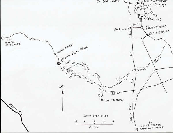
On the Camino Real from the Gonzaga Bay side at Arroyo Santa Maria, up the mountain to the road below the mission... is maybe 5-6 hiking miles. 'Don
Jorge' may still have the data as he walked and mapped the entire route in 2003 after my son and I got about 2/3 up. From the road/ El Camino Real
junction to the mission is 1.5 miles.
This sign is along the trail up in the first valley after climbing out of Arroyo Santa Maria:

Here I am on the Camino Real in November, 2003... Arroyo Santa Maria is way in the background...

|
|
|
BAJACAT
Ultra Nomad
Posts: 2902
Registered: 11-21-2005
Location: NATIONAL CITY, CA
Member Is Offline
|
|
You answer my question, 5 to 6 hiking miles, to reach the mission..
BAJA IS WHAT YOU WANTED TO BE, FUN,DANGEROUS,INCREDIBLE, REMOTE, EXOTIC..JUST GO AND HAVE FUN.....
|
|
|
David K
Honored Nomad
Posts: 65570
Registered: 8-30-2002
Location: San Diego County
Member Is Offline
Mood: Have Baja Fever
|
|
That is an educated guess Jose... As I mentioned, Baja Nomad member 'Don Jorge' followed us up the Camino Real a week or so later that year and
recorded waypoints and mapped the trail on a topo... See Don Jorge's reply in 2003: http://forums.bajanomad.com/viewthread.php?tid=1408#pid12470
He reported 8 miles up the Camino Real to the mission taking 5.5 hrs. So, it is 6.5 miles on the trail from the arroyo start to the road, 1.5 miles
below the mission.
[Edited on 10-14-2008 by David K]
|
|
|
BAJACAT
Ultra Nomad
Posts: 2902
Registered: 11-21-2005
Location: NATIONAL CITY, CA
Member Is Offline
|
|
David I was triying to find the indian trail from Rancho San Luis to GC..I found the ranch, but then i losse the trail..
BAJA IS WHAT YOU WANTED TO BE, FUN,DANGEROUS,INCREDIBLE, REMOTE, EXOTIC..JUST GO AND HAVE FUN.....
|
|
|
mcbockalds
Junior Nomad
Posts: 25
Registered: 3-4-2008
Location: Duluth, MN
Member Is Offline
|
|
I was aware that Google Earth photos were not recent. So how did someone recently post the satelite photo of the recent hurricane/cloud cover passing
over Baja? I thought it was from Google Earth - no?
Cheers, John
\"The best things in life aren\'t things\"
|
|
|
David K
Honored Nomad
Posts: 65570
Registered: 8-30-2002
Location: San Diego County
Member Is Offline
Mood: Have Baja Fever
|
|
No... at least from my point of view!
Google Earth, Google Maps (satellite) and Wikimapia all use images that seem to have been taken over the past 5 years or so.
Anything showing recent weather is from the weather satellites...
The interesting thing is more and more of Baja that was not in high resolution for zoom in (to see houses, cars on the road, etc.) is getting
included. Not sure if it is new imaging or just higher resolution versions of past images.
http://wikimapia.org and zoom in on Baja or where-ever you want!
[Edited on 10-21-2008 by David K]
|
|
|
CaboRon
Ultra Nomad
Posts: 3401
Registered: 3-24-2007
Location: The Valley of the Moon
Member Is Offline
Mood: Peacefull
|
|
| Quote: | Originally posted by mcbockalds
I was aware that Google Earth photos were not recent. So how did someone recently post the satelite photo of the recent hurricane/cloud cover passing
over Baja? I thought it was from Google Earth - no?
Cheers, John |
The chubasco sat photos were from the National Hurricane Center.
CaboRon
|
|
|
|