| Pages:
1
2 |
David K
Honored Nomad

Posts: 65546
Registered: 8-30-2002
Location: San Diego County
Member Is Offline
Mood: Have Baja Fever
|
|
Just for fun, old map game... 1941 Map and more!
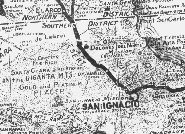
This is part of one of the maps in my collection... It is one of the oldest 'road maps' of Baja.
THREE QUESTIONS:
Does any Nomad care to guess at the year it was made? How many times do you see the word 'unexplored' on it? What is wrong with one of the missions
shown?
PS Neal Johns is disqualified from answering  (not only does he have this map,
but he probably drew it!) (not only does he have this map,
but he probably drew it!)
[Edited on 11-10-2008 by David K]
|
|
|
CaboRon
Ultra Nomad
Posts: 3401
Registered: 3-24-2007
Location: The Valley of the Moon
Member Is Offline
Mood: Peacefull
|
|
1978
|
|
|
Udo
Elite Nomad
Posts: 6364
Registered: 4-26-2008
Location: Black Hills, SD/Ensenada/San Felipe
Member Is Offline
Mood: TEQUILA!
|
|
1959.
Unexplored appears only once.
The Dolores Del Norte mission ruins should be farther East.
Udo
Youth is wasted on the young!
|
|
|
David K
Honored Nomad
Posts: 65546
Registered: 8-30-2002
Location: San Diego County
Member Is Offline
Mood: Have Baja Fever
|
|
Hint: In 1978, the highway was already built and didn't go through El Arco. That solid heavy line indicates the main road and not a paved road.
Udo, try again on all three!
|
|
|
toneart
Ultra Nomad
Posts: 4901
Registered: 7-23-2006
Member Is Offline
Mood: Skeptical
|
|
Just a blind shot:
1974.
Regarding mission, wouldn't Delores del Norte be north of the state line?
|
|
|
cristobal
Nomad
Posts: 194
Registered: 12-16-2003
Location: california
Member Is Offline
|
|
I'll say ....1940
Gertrudis is farther SOUTH
I see two ... UNEXPLORED ...
   
[Edited on 11-8-2008 by cristobal]
|
|
|
cristobal
Nomad
Posts: 194
Registered: 12-16-2003
Location: california
Member Is Offline
|
|
Let me try again ... 1920
Santa Gertrudis is in BAJA SUR
I still just see TWO unexplored ...
Santa Gertrudis used to be called ...
Dolores Del Norte
|
|
|
woody with a view
PITA Nomad
Posts: 15940
Registered: 11-8-2004
Location: Looking at the Coronado Islands
Member Is Offline
Mood: Everchangin'
|
|
3 unexplored, but who's counting?
|
|
|
David K
Honored Nomad
Posts: 65546
Registered: 8-30-2002
Location: San Diego County
Member Is Offline
Mood: Have Baja Fever
|
|
You guys are getting better!
There are 3 missions shown on that map: Santa Gertrudis, Dolores del Norte, and San Ignacio. Another mission is just off the map, but part of the name
'Guadalupe' is seen at the bottom.
Cristobal is correct on one item: Santa Gertrudis was initially to be called Dolores del Norte! But, since Jesuit records were not fully understood by
some writers... When they saw the name 'Dolores' mentioned and on the 1757 map, north of San Ignacio, it was assumed to be another mission besides
Santa Gertrudis.
The visita ruins of San Pablo have been mistaken to be the mission of Dolores del Norte by some authors and even INAH!
On this map, both San Pablo and Dolores del Norte are shown... but the Dolores del Norte shown, is an error... No such site (seperate from San Pablo
or Santa Gertrudis) exists. This error was repeated on many maps, including the older Automobile Club of So. Calif. Baja folding map and the Mike
McMahan wall maps.
Great to see you here, cristobal!
As for the 'Unexplored', Woody wins (as I saw it in three places, too).
The year... well... one of you was really close!
|
|
|
redmesa
Senior Nomad
Posts: 580
Registered: 3-12-2008
Location: Van Isle and Bahia Asuncion
Member Is Offline
|
|
I'll play. My uncle lost his silver mine to the revolution in the thirties and I see on this map that the placer mines are still marked...so I guess
hmmm 1932?
|
|
|
cristobal
Nomad
Posts: 194
Registered: 12-16-2003
Location: california
Member Is Offline
|
|
1922
|
|
|
toneart
Ultra Nomad
Posts: 4901
Registered: 7-23-2006
Member Is Offline
Mood: Skeptical
|
|
| Quote: | Originally posted by David K
You guys are getting better!
There are 3 missions shown on that map: Santa Gertrudis, Dolores del Norte, and San Ignacio. Another mission is just off the map, but part of the name
'Guadalupe' is seen at the bottom.
Cristobal is correct on one item: Santa Gertrudis was initially to be called Dolores del Norte! But, since Jesuit records were not fully understood by
some writers... When they saw the name 'Dolores' mentioned and on the 1757 map, north of San Ignacio, it was assumed to be another mission besides
Santa Gertrudis.
The visita ruins of San Pablo have been mistaken to be the mission of Dolores del Norte by some authors and even INAH!
On this map, both San Pablo and Dolores del Norte are shown... but the Dolores del Norte shown, is an error... No such site (seperate from San Pablo
or Santa Gertrudis) exists. This error was repeated on many maps, including the older Automobile Club of So. Calif. Baja folding map and the Mike
McMahan wall maps.
Great to see you here, cristobal!
As for the 'Unexplored', Woody wins (as I saw it in three places, too).
The year... well... one of you was really close! |
David,
Was I so far off that you didn't acknowledge my try?
|
|
|
David K
Honored Nomad
Posts: 65546
Registered: 8-30-2002
Location: San Diego County
Member Is Offline
Mood: Have Baja Fever
|
|
| Quote: | Originally posted by toneart
Just a blind shot:
1974.
Regarding mission, wouldn't Delores del Norte be north of the state line? |
"David,
Was I so far off that you didn't acknowledge my try?"
Thanks for participating toneart... I felt it was fair to let those with correct answers know and to provide more hints as the game progressed. The
year on the map will be revealed tomorrow, one of the guesses was off by just one year (as I said before)... at least that is what I recall the year
of that map was... It is rolled up in a tube, and I haven't looked it over for acouple years!
As for your guesses:
1974 was after the new highway was built. The heavy black line on this map was the main transpeninsular road. It was a dirt track, not graded, and
went through El Arco. Guerrero Negro town was still many years from existing when this map was made. However, when the new highway was built in 1973,
Guerrero Negro was more important than El Arco so the highway passed near it and El Arco got a paper thin paved side road which soon disitigrated.
There was never a physical mission called Dolores del Norte, only in the Jesuit records as a proposed name for the next mission north of San Ignacio.
When funds were finally available for that mission, a new name (Santa Gertrudis) was used. The visita of San Pablo was erroneously called Dolores del
Norte by some authors and INAH... On this map, San Pablo, Santa Gertrudis and Dolores all are shown seperately... There was no 'state line' when a
mission named Dolores del Norte was proposed... that was even before there was a country of Mexico... The peninsula was 'California' and the land to
the north of the peninsula was later called 'Alta California'. Things sure got switched around!
For more on Dolores del Norte, see http://vivabaja.com/1757
This is great for learning a bit about the fascinating and mysterious history of Baja, the original California!
[Edited on 11-10-2008 by David K]
|
|
|
toneart
Ultra Nomad
Posts: 4901
Registered: 7-23-2006
Member Is Offline
Mood: Skeptical
|
|
David,
Very interesting!
I erroneously assumed the thick black line was the paved hwy, new in 1973. I also assumed that the map was crudely drawn by an amateur (the Neal Johns
reference threw me off in 1974.
I'll look forward to the correct answer. Don't give it away. Make them/us work for it.
Tony
|
|
|
David K
Honored Nomad
Posts: 65546
Registered: 8-30-2002
Location: San Diego County
Member Is Offline
Mood: Have Baja Fever
|
|
| Quote: | Originally posted by toneart
David,
Very interesting!
I erroneously assumed the thick black line was the paved hwy, new in 1973. I also assumed that the map was crudely drawn by an amateur (the Neal Johns
reference threw me off in 1974.
I'll look forward to the correct answer. Don't give it away. Make them/us work for it.
Tony |
You bet... no problema... (see my hint post right above your 10:03 am guess)
Thanks for playing Tony... and I thought your name was 'Art' and played music, all along! (tone- art)!  
|
|
|
toneart
Ultra Nomad
Posts: 4901
Registered: 7-23-2006
Member Is Offline
Mood: Skeptical
|
|
1958

|
|
|
David K
Honored Nomad
Posts: 65546
Registered: 8-30-2002
Location: San Diego County
Member Is Offline
Mood: Have Baja Fever
|
|
Okay Tony... it was Cristobal who was the closest... the map was made in 1941 and is very detailed with descriptions, a road log, history, etc. Like a
Baja guidebook on a map!
I will try and scan more of it... stay tuned!
|
|
|
David K
Honored Nomad
Posts: 65546
Registered: 8-30-2002
Location: San Diego County
Member Is Offline
Mood: Have Baja Fever
|
|
The south end of Baja, 1941

|
|
|
Bob H
Elite Nomad
Posts: 5867
Registered: 8-19-2003
Location: San Diego
Member Is Offline
|
|
David, this is a very cool thread.
Thanks,
Bob H
|
|
|
David K
Honored Nomad
Posts: 65546
Registered: 8-30-2002
Location: San Diego County
Member Is Offline
Mood: Have Baja Fever
|
|
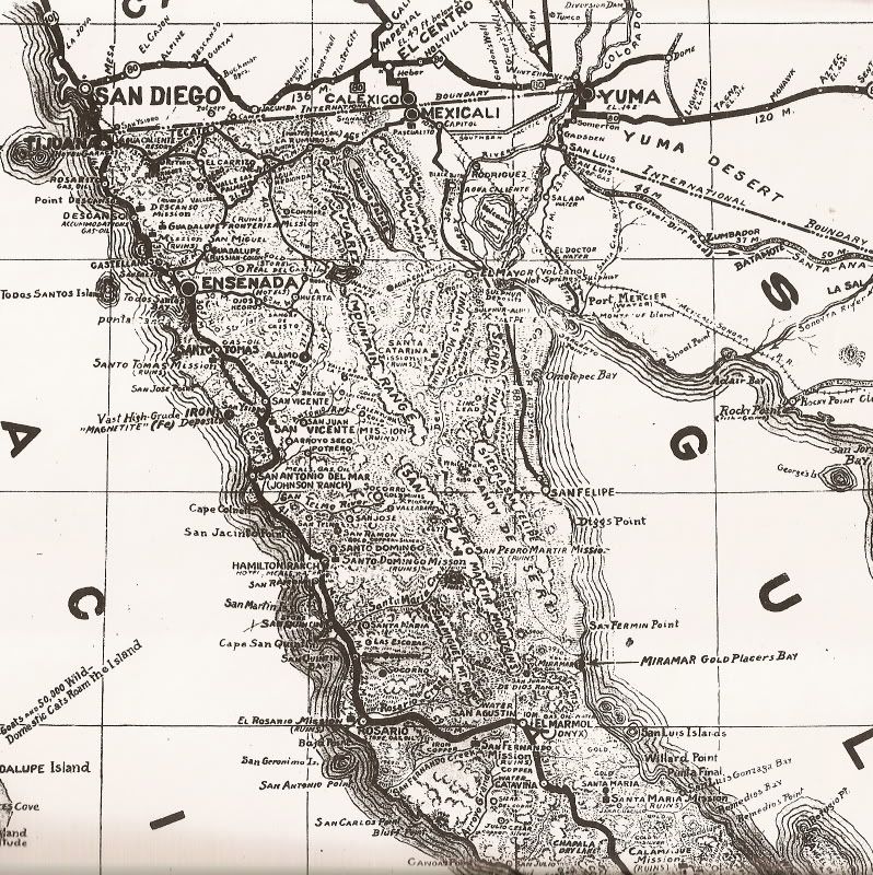
Thanks Bob... Here is the north end of 1941 Baja... then it's time to watch some FOOTBALL!
|
|
|
| Pages:
1
2 |