| Pages:
1
2 |
BajaGringo
Ultra Nomad

Posts: 3922
Registered: 8-24-2006
Location: La Chorera
Member Is Offline
Mood: Let's have a BBQ!
|
|
OK, I'll play. Bring on another map!
|
|
|
David K
Honored Nomad
Posts: 65549
Registered: 8-30-2002
Location: San Diego County
Member Is Offline
Mood: Have Baja Fever
|
|
After the Charges beat KC!
|
|
|
Skipjack Joe
Elite Nomad
Posts: 8092
Registered: 7-12-2004
Location: Bahia Asuncion
Member Is Offline
|
|
I'd put this map somewhere between 1920 and 1940. I had a baja map around 1960 (spelled out the game available for hunters) and it was considerably
more advanced than this one.
|
|
|
David K
Honored Nomad
Posts: 65549
Registered: 8-30-2002
Location: San Diego County
Member Is Offline
Mood: Have Baja Fever
|
|
| Quote: | Originally posted by David K
Okay Tony... it was Cristobal who was the closest... the map was made in 1941 and is very detailed with descriptions, a road log, history, etc. Like a
Baja guidebook on a map!
I will try and scan more of it... stay tuned! |
1941
Here is the central section:

|
|
|
David K
Honored Nomad
Posts: 65549
Registered: 8-30-2002
Location: San Diego County
Member Is Offline
Mood: Have Baja Fever
|
|
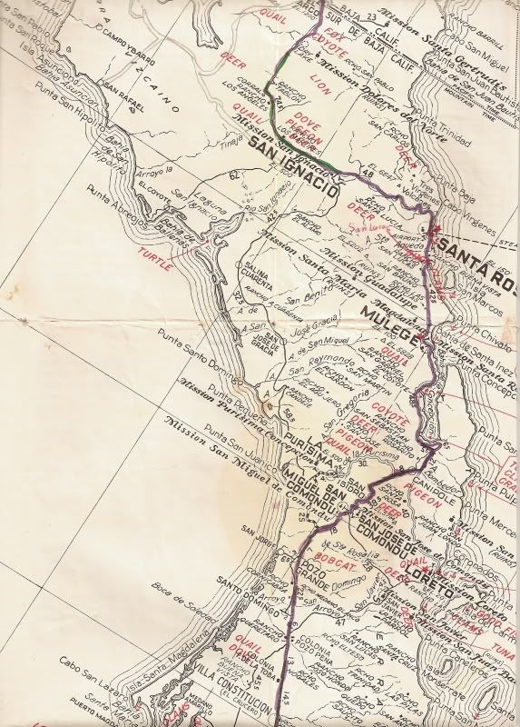
Because the area just north of Bahia de los Angeles is fuzzy, here is a closer look at the section from El Rosario to El Arco (the south part of Baja
Norte):

|
|
|
David K
Honored Nomad
Posts: 65549
Registered: 8-30-2002
Location: San Diego County
Member Is Offline
Mood: Have Baja Fever
|
|
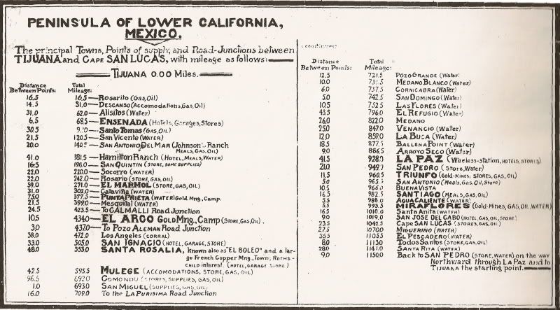
Here is the 1941 road log from that map:
|
|
|
David K
Honored Nomad
Posts: 65549
Registered: 8-30-2002
Location: San Diego County
Member Is Offline
Mood: Have Baja Fever
|
|
| Quote: | Originally posted by Skipjack Joe
I'd put this map somewhere between 1920 and 1940. I had a baja map around 1960 (spelled out the game available for hunters) and it was considerably
more advanced than this one. |
You are describing the old Automobile Club map of the mid 1960's
It did copy some features off this 1941 map, including showing a mission of Dolores del Norte (that isn't there)...
Here's a couple of parts of it:
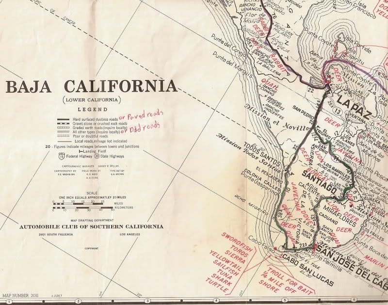
After our 1966 trip to the tip of Baja, I (age 8-9) marked our route... the only pavement in Baja Sur then was for a hundred miles north of La Paz and
10 miles south of La Paz.
[Edited on 11-10-2008 by David K]
|
|
|
Udo
Elite Nomad
Posts: 6364
Registered: 4-26-2008
Location: Black Hills, SD/Ensenada/San Felipe
Member Is Offline
Mood: TEQUILA!
|
|
Our Chargers, held off the charge from KC!
Udo
Youth is wasted on the young!
|
|
|
surfer jim
Super Nomad
Posts: 1891
Registered: 8-29-2003
Location: high desert
Member Is Offline
|
|
Love these maps.....
Side note to northern portion map at end of page 1.....Years ago I was camping at CUATRO CASAS (few miles south of Colonet Point) and was talking to a
son of INEZ ( he was the owner of the "4 houses").......remember him telling me the "main" road from Ensenada used to pass by their location on its
way south....looking at the map shows it doing just that before it gets to Hamilton Ranch to the south.......
Also...anybody know anything about the IRON deposit located between Santo Thomas and Colonet.....looks to be on/near the beach?
|
|
|
David K
Honored Nomad
Posts: 65549
Registered: 8-30-2002
Location: San Diego County
Member Is Offline
Mood: Have Baja Fever
|
|
| Quote: | Originally posted by surfer jim
Love these maps.....
Side note to northern portion map at end of page 1.....Years ago I was camping at CUATRO CASAS (few miles south of Colonet Point) and was talking to a
son of INEZ ( he was the owner of the "4 houses").......remember him telling me the "main" road from Ensenada used to pass by their location on its
way south....looking at the map shows it doing just that before it gets to Hamilton Ranch to the south.......
Also...anybody know anything about the IRON deposit located between Santo Thomas and Colonet.....looks to be on/near the beach?
|
Jim... here is the 1927 Auto Club map... as you can see the first main road hugged the coast, as you were told!
Shall I post the other two in this thread?
[Edited on 11-11-2008 by David K]
|
|
|
Jack Swords
Super Nomad
Posts: 1097
Registered: 8-30-2002
Location: Nipomo, CA/La Paz, BCS
Member Is Offline
|
|
David...did you notice on the south portion of the old AAA map the "Mission el Novillo" at San Pedro? Wonder how it got labeled as such? You have
the photo before it fell down a couple of years ago. I know INAH had been out to the site, but looked like a small chapel to me. It is on Rancho
Novillo dating back to that era. Up above the chapel on the Trinchera range is the estancia el Zalate. Need to go back!
|
|
|
David K
Honored Nomad
Posts: 65549
Registered: 8-30-2002
Location: San Diego County
Member Is Offline
Mood: Have Baja Fever
|
|
| Quote: | Originally posted by Jack Swords
David...did you notice on the south portion of the old AAA map the "Mission el Novillo" at San Pedro? Wonder how it got labeled as such? You have
the photo before it fell down a couple of years ago. I know INAH had been out to the site, but looked like a small chapel to me. It is on Rancho
Novillo dating back to that era. Up above the chapel on the Trinchera range is the estancia el Zalate. Need to go back! |
Yes Jack... I was wondering when you would say something!
Here is your photo of the 'Mission' of El Novillo:

Did you have any photos from last time in La Paz to add to your web page? http://vivabaja.com/swords
|
|
|
BajaNuts
Super Nomad
Posts: 1085
Registered: 5-11-2008
Location: eastern WA, the DRY side
Member Is Offline
Mood: no worry, no hurry....it's all good!
|
|
Very Fun! I'd love to see progressive maps of a certain area if those that have them would like to share them. Pick an area and the show the oldest
map, a newer one, and the latest one.
Or more contests are fun too! thanks for sharing >>>>>
|
|
|
surfer jim
Super Nomad
Posts: 1891
Registered: 8-29-2003
Location: high desert
Member Is Offline
|
|
Thanks for the detail.....guess it makes sense as the area is very flat....also looks like a "barge" was available to cross the river at Colonet
point...
|
|
|
jodiego
Nomad
Posts: 319
Registered: 2-16-2007
Location: San Diego
Member Is Offline
Mood: ever hopeful
|
|
| Quote: | Originally posted by David K
Here is the 1941 road log from that map:
|
.
Cape San Lucas.....stores, gas, oil. My how times have changed.
|
|
|
David K
Honored Nomad
Posts: 65549
Registered: 8-30-2002
Location: San Diego County
Member Is Offline
Mood: Have Baja Fever
|
|
jodiego, when I first went to (Cabo) San Lucas, it was 1966 and it was a small fish canery town with a pier. There was one tourist hotel, the Hacienda
and visitors mostly arrived by private plane landing on the mud flats behind the hotel. That is where the harbor is today! My next visit was in 1974,
and the place was totally changed... The Finisterra and Solmar had been built, a harbor was being dredged, a ferry landing built for the Puerto
Vallarta ferry line... oh, and a paved highway all the way to Tijuana!
|
|
|
David K
Honored Nomad
Posts: 65549
Registered: 8-30-2002
Location: San Diego County
Member Is Offline
Mood: Have Baja Fever
|
|
OK Nomads... I have rescanned the 1941 map and also scanned my 1919 map (from 1905/06 suryeys) , and a 1905 mines and roads maps... I also have a
differnt 1919 map of Northern Baja and a 1930 map...
Please go to the Baja Nomad Historic Interest and Literatur forum to see them! >>> http://forums.bajanomad.com/forumdisplay.php?fid=24
[Edited on 11-12-2008 by David K]
|
|
|
| Pages:
1
2 |


