| Pages:
1
2 |
David K
Honored Nomad

Posts: 65549
Registered: 8-30-2002
Location: San Diego County
Member Is Offline
Mood: Have Baja Fever
|
|
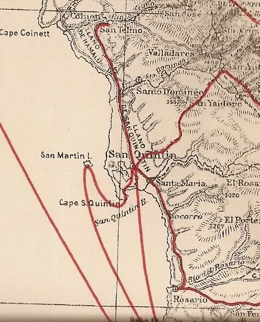
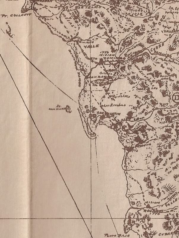
MAPS showing San Quintin, over the years
1888...
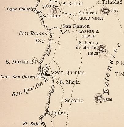
1905 Mines & Roads...
1919...
1919 Goldbaum Map...
1927...
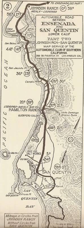
1930...
1941...
1962...
Please let me know if there is an area of Baja you would like to see on these old maps, up close!
|
|
|
BajaGringo
Ultra Nomad
Posts: 3922
Registered: 8-24-2006
Location: La Chorera
Member Is Offline
Mood: Let's have a BBQ!
|
|
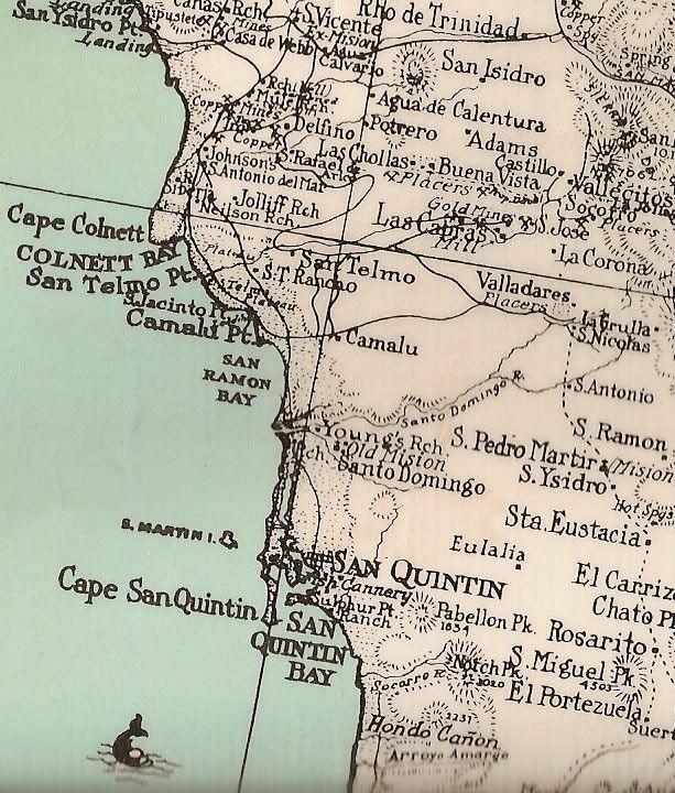
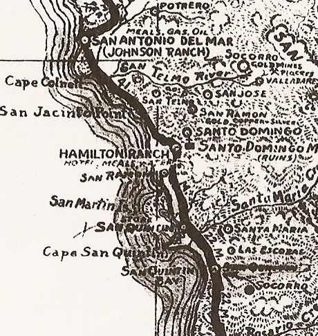
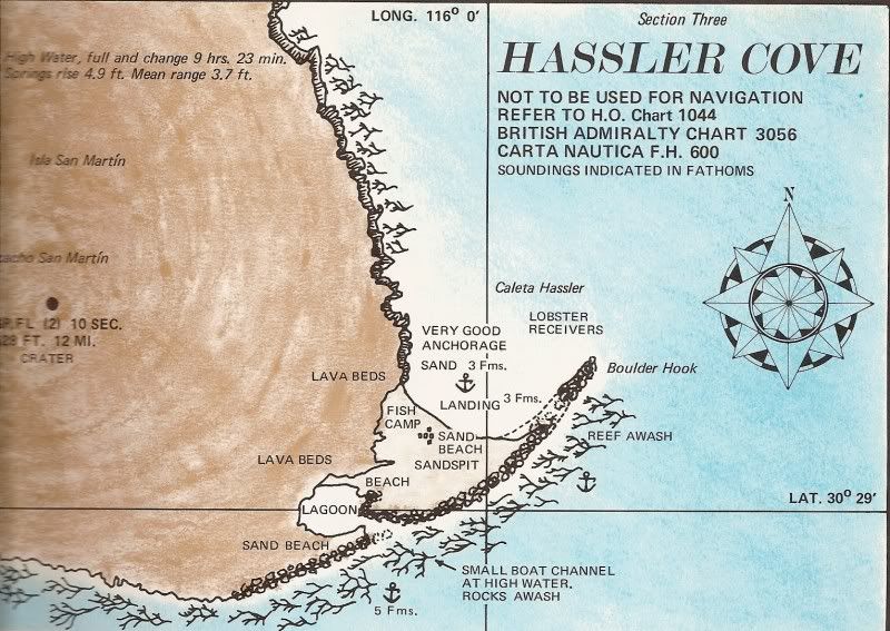
Looking on one of the maps I see they labeled the cove in front of San Martin island as "Hassler Cove". Will do some investigating on that...
These are Ggeat David - thanks!!!
|
|
|
David K
Honored Nomad
Posts: 65549
Registered: 8-30-2002
Location: San Diego County
Member Is Offline
Mood: Have Baja Fever
|
|
| Quote: | Originally posted by BajaGringo
Looking on one of the maps I see they labeled the cove in front of San Martin island as "Hassler Cove". Will do some investigating on that...
These are Ggeat David - thanks!!! |
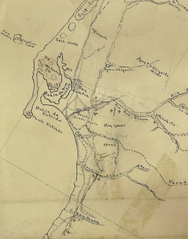
Here's some more on Hassler Cove:

|
|
|
BajaGringo
Ultra Nomad
Posts: 3922
Registered: 8-24-2006
Location: La Chorera
Member Is Offline
Mood: Let's have a BBQ!
|
|
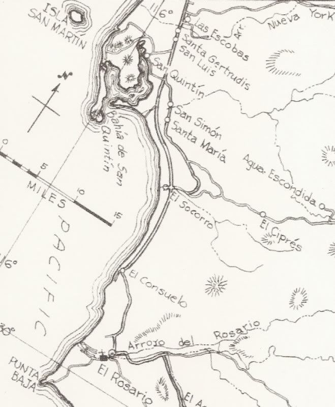
David, do you have more on the island and especially more of the second map? It sits right in front of where I am building...
|
|
|
David K
Honored Nomad
Posts: 65549
Registered: 8-30-2002
Location: San Diego County
Member Is Offline
Mood: Have Baja Fever
|
|
| Quote: | Originally posted by BajaGringo
David, do you have more on the island and especially more of the second map? It sits right in front of where I am building... |
That is pretty much all of that map... just a tiny bit was cut off on the left... The edge of the map is just left of the word Picacho (San Martin),
and you can see that only Pic of Picacho are missing.
The above two images are from the 1971 Baja Sea Guide.
More on Isla San Martin can be found in 'The Baja Adventure Book' by Walt Peterson... still sold with new reprints in the bookstores or here on Baja
Nomad Tienda, etc.
|
|
|
TMW
Select Nomad
Posts: 10659
Registered: 9-1-2003
Location: Bakersfield, CA
Member Is Offline
|
|
Where was the Hamilton Ranch hotel? From the 1941 map it looks like it was where hwy1 is today west of Santo Domingo. But either on here or in one of
the books I was reading there was a story about some auther who was there recently and it was more of an abandoned place not near the hwy.
|
|
|
BajaGringo
Ultra Nomad
Posts: 3922
Registered: 8-24-2006
Location: La Chorera
Member Is Offline
Mood: Let's have a BBQ!
|
|
I took a road trip on the old road recently with a local who grew up in the area. He told me that there was a stop called Hamilton Ranch along the
coast. It had a restaurant, rooms for overnight guests and gas. The Hamilton Ranch itself is still in operation several miles to the east of the old
stop and about a mile east of the current paved highway 1.
Today very little remains at all of the old stop.
If you look at the 1927 and 1941 maps you will see that the road there seems to have been re-routed east...
[Edited on 12-2-2008 by BajaGringo]
|
|
|
TonyC
Nomad
Posts: 421
Registered: 1-25-2008
Member Is Offline
|
|
San QuEntin
Thank you David. Very cool maps. 1888, and 1927 San Quintin spelled with a E was correct. 
[Edited on 12-3-2008 by TonyC]
|
|
|
David K
Honored Nomad
Posts: 65549
Registered: 8-30-2002
Location: San Diego County
Member Is Offline
Mood: Have Baja Fever
|
|
Colnett is also the correct spelling of the Englishman the cape was named after... but the Mexicans liked their version COLONET better! 
TW, the Hamilton Guest Ranch and airstrip is east of the highway near the hills... When you drive along Arroyo Santo Domingo to see the mission, the
Hamilton Ranch (HR) can be seen on the south side if the big arroyo.
I think showing it close to the ocean is an error... The Hamilton Ranch was a hide-a-way for the Hollywood stars to have their parties far from the
press's cameras... Erle Stanley Gardner used it as a stop over often in the 60's.
|
|
|
BajaGringo
Ultra Nomad
Posts: 3922
Registered: 8-24-2006
Location: La Chorera
Member Is Offline
Mood: Let's have a BBQ!
|
|
David - I was told by those who grew up in the area that the coastal stop was referred to as Hamilton Ranch. At one time there was a bus that made
the trip down the coast and that is where you would get off if you were heading out to the ranch...
|
|
|
David K
Honored Nomad
Posts: 65549
Registered: 8-30-2002
Location: San Diego County
Member Is Offline
Mood: Have Baja Fever
|
|
The 'Hamilton Ranch Bus Stop'... sure that sounds about right.
Have you seen the remains of the Hamilton Ranch motel cabins... big trees over them I recall from photos? Gardner really liked it there... the famous
Hattie Hamilton Ranch, he called it...operated by Margo Cesena (in 1966).
|
|
|
BajaGringo
Ultra Nomad
Posts: 3922
Registered: 8-24-2006
Location: La Chorera
Member Is Offline
Mood: Let's have a BBQ!
|
|
I haven't made it over to check those out yet David but will our next time. I will be going up the road to check out the old mission and as I recall
that road runs right next to the old ranch...
|
|
|
BajaGeoff
Super Nomad
Posts: 1727
Registered: 1-11-2006
Location: San Diego and Campo Lopez
Member Is Offline
Mood: Heading To Baja!!!
|
|
Great stuff David! Always fun to see old maps and how they evolve over the years
|
|
|
David K
Honored Nomad
Posts: 65549
Registered: 8-30-2002
Location: San Diego County
Member Is Offline
Mood: Have Baja Fever
|
|
Thanks Geoff!
BajaGringo, here's the 1962 map close up... The Hamilton Ranch was 3 miles from the main road, east of Colonia Guerrero, near the edge of the Santo
Domingo riverbed.

|
|
|
David K
Honored Nomad
Posts: 65549
Registered: 8-30-2002
Location: San Diego County
Member Is Offline
Mood: Have Baja Fever
|
|
Hamilton Ranch in one of these tree areas:
Hamilton Ranch area
|
|
|
Gaucho
Nomad
Posts: 405
Registered: 11-7-2008
Location: Laguna Beach/East Cape
Member Is Offline
Mood: Bohemia por favor...
|
|
Hi David,
Can you show an area of the lower east cape say from Los Frailles to Los Zacatitos?
Thanks
|
|
|
David K
Honored Nomad
Posts: 65549
Registered: 8-30-2002
Location: San Diego County
Member Is Offline
Mood: Have Baja Fever
|
|
| Quote: | Originally posted by Gaucho
Hi David,
Can you show an area of the lower east cape say from Los Frailles to Los Zacatitos?
Thanks |
Be happy to... look for it soon/ now as a new thread (post) in this forum!
HERE THEY ARE: http://forums.bajanomad.com/viewthread.php?tid=35763
[Edited on 12-10-2008 by David K]
|
|
|
BajaGringo
Ultra Nomad
Posts: 3922
Registered: 8-24-2006
Location: La Chorera
Member Is Offline
Mood: Let's have a BBQ!
|
|
Curiosity got the best of me and I made a trip out to see San Martin Island. Here is view of the mainland west of San Quintin, taken from the island.
The area where we are building is located just to the right/south of the cantiles, below the largest volcano/cinder cone.

|
|
|
Gaucho
Nomad
Posts: 405
Registered: 11-7-2008
Location: Laguna Beach/East Cape
Member Is Offline
Mood: Bohemia por favor...
|
|
BajaGringo,
What a great spot to build. How is the diving around there? It looks like the vis around San Martin is pretty good.
|
|
|
BajaGringo
Ultra Nomad
Posts: 3922
Registered: 8-24-2006
Location: La Chorera
Member Is Offline
Mood: Let's have a BBQ!
|
|
The visibility is incredible. On the east side of the island you can see every detail of the ocean floor below at 20' like it was your backyard pool.
I am taking my goggles and fins next time...
|
|
|
| Pages:
1
2 |


