| Pages:
1
2
3 |
David K
Honored Nomad

Posts: 65590
Registered: 8-30-2002
Location: San Diego County
Member Is Offline
Mood: Have Baja Fever
|
|
I just did Ken!
|
|
|
Steve&Debby
Nomad
Posts: 335
Registered: 12-18-2007
Location: Colusa,California/ Percebu
Member Is Offline
|
|
Ken,
Great video,Johnson Valley is on my list of places to go.Have you ever run the Hammers?I have seen video of the Hammers they look like they would be
very tough.Do you have any video of the Hammers?
David,thanks for the information.I thought it would be alot farhter to go to San Felipe then to the Mission.We will probably have to try the Mission
run In December when we go down looking for some property.Unless I can make it in November when Ken's group goes through.
|
|
|
Ken Cooke
Elite Nomad
Posts: 8971
Registered: 2-9-2004
Location: Riverside, CA
Member Is Offline
Mood: Pole Line Road postponed due to injury
|
|
| Quote: | Originally posted by Steve& ebby ebby
Ken,
Great video,Johnson Valley is on my list of places to go.Have you ever run the Hammers?I have seen video of the Hammers they look like they would be
very tough.Do you have any video of the Hammers? |
Johnson Valley might be converted into a military bombing range, so you need to visit there quickly, as my Baja buddies are doing at the moment. 
I haven't run the Hammers, but there is video on YouTube. Bullfrog is fairly tough, but with the right spotting, almost anyone can make it through.
The only thing comparable in Baja would be Jacume (or Smuggler's Cyn) just outside of Tecate. In the U.S., there is Jacumba which is the opposite
side of the border from Jacume. Very fun place, IMO.
|
|
|
Steve&Debby
Nomad
Posts: 335
Registered: 12-18-2007
Location: Colusa,California/ Percebu
Member Is Offline
|
|
Ken,
Do you have any video or pictures of the places out side Tecate?
|
|
|
Ken Cooke
Elite Nomad
Posts: 8971
Registered: 2-9-2004
Location: Riverside, CA
Member Is Offline
Mood: Pole Line Road postponed due to injury
|
|
| Quote: | Originally posted by Steve&ebby
Ken,
Do you have any video or pictures of the places out side Tecate? |
http://www.justruns.com/gallery2/v/Run+Photos/070508/


|
|
|
David K
Honored Nomad
Posts: 65590
Registered: 8-30-2002
Location: San Diego County
Member Is Offline
Mood: Have Baja Fever
|
|
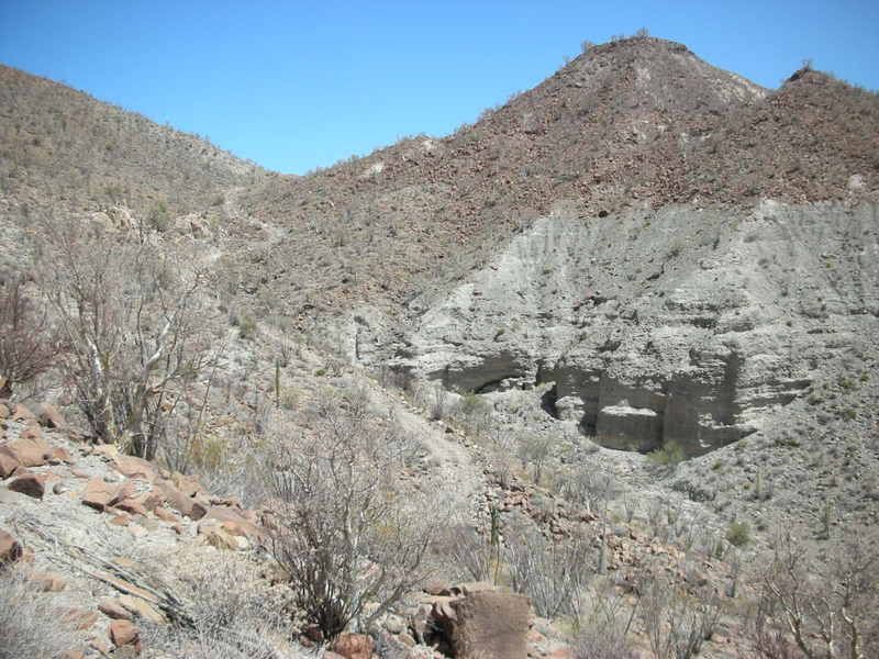
Steve and Ken...
... I was going through my photos and found this one that shows the last part of the bulldozed road, climbing up to end on the ridge by the
petroglyphs.
This is taken from the El Camino Real which climbs up the steep slope, northwest from the road...
|
|
|
David K
Honored Nomad
Posts: 65590
Registered: 8-30-2002
Location: San Diego County
Member Is Offline
Mood: Have Baja Fever
|
|
Here's looking the other direction, towards Arroyo Santa Maria about where tha Camino Real meets the bulldozed road... That's TheSquarecircle heading
back towards the arroyo... This is about 1.5 miles from Mision Santa Maria...
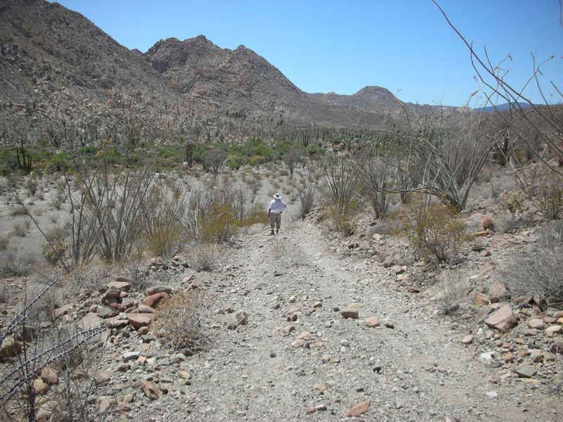
[Edited on 2-13-2009 by David K]
|
|
|
Steve&Debby
Nomad
Posts: 335
Registered: 12-18-2007
Location: Colusa,California/ Percebu
Member Is Offline
|
|
David,
Is this past the Mission or before it?
|
|
|
David K
Honored Nomad
Posts: 65590
Registered: 8-30-2002
Location: San Diego County
Member Is Offline
Mood: Have Baja Fever
|
|
Steve... that is the bulldozed / end of the road, past the mission... about 2 miles.
The ECR takes off up the steep hill on your left at 1.5 miles... Rocks get so big, stock 4X4s need to park a bit past the ECR.
To get to the ECR and bulldozed grade:
Turn left out of the sandy arroyo (hidden by youing palm) at 1.3 mile from the mission. If you stay in the arroyo you will come to the dead end in the
palms and rocks 1/4 mile ahead... Please review all the previous posts, photos, etc.
The misson is 14.3-14.5 miles from Rancho Santa Ynez. The road continues past the mission then drops down a very steep grade into the sandy arroyo at
Mile 1.0. Nice camping if you turn left in the arroyo and go to the oasis pond.
|
|
|
Steve&Debby
Nomad
Posts: 335
Registered: 12-18-2007
Location: Colusa,California/ Percebu
Member Is Offline
|
|
Thanks,David and Ken
I will probaly forget all the great information that you and Ken have given to me.I can't wait until I can get back down there.We are going to try and
go down to the San Felipe area to look for a house or lot buy around Easter.
|
|
|
David K
Honored Nomad
Posts: 65590
Registered: 8-30-2002
Location: San Diego County
Member Is Offline
Mood: Have Baja Fever
|
|
10-4... You can print out the pages on Nomad (click on 'Printable Version) and put them in a binder and take with you!
Also see my new post 'See El Camino Real: Mision Santa Maria to San Borja, from space' I jus added this morning for more views of the area east and
south from Santa Maria...
As for your plane question I saw... there is an open airport (dirt strip) at El Vergel, (Km. 35) south of San Felipe... That one you may check in on
as far as buying a home in the area.
Next airstrip is at Coloradito about 10 more miles south, but it may not be open... then Puertecitos (is open).
Between Puetecitos and Gonzaga are/ were strips at El Huerfanito and Punta Bufeo, but either of them may now be closed...
San Felipe is an International airport and you can check into Mexico there after leaving U.S. airspace. All other pilot questions, I refer you to the
many Baja Nomad pilots (Skeet, Capt. Mike, Beercan, Fishbuck, steekers, etc.).
Joining the Baja Bush Pilots is recommended... You now must join them to see their forums... lots of info and airport photos... and get 'Airports of
Mexico'. The book 'Fly Baja!' is great... color airport photos, easy to use size... but several years old, now... and many of the runways listed have
been ditched by the army in the anti-drug program, since drug runners use remote strips.
|
|
|
Steve&Debby
Nomad
Posts: 335
Registered: 12-18-2007
Location: Colusa,California/ Percebu
Member Is Offline
|
|
Thanks again David,you are a wealth af information on Baja.We have 4 lots up in snow country in Northern California,we are building a cabin on one of
them and hope to sell the cabin and get some property in Baja.Then we will get serious about the plane.
|
|
|
steekers
Nomad
Posts: 257
Registered: 12-4-2007
Member Is Offline
|
|
aerials of Santa Maria
I know David K has some aerial of Santa Maria and the canyons close by.
Any other Nomads have some good aerials?
As part of my Easter break, I am planning to fly into several airstrips in that area. While I am airborne, I will try and get some pics of the
canyons.
|
|
|
David K
Honored Nomad
Posts: 65590
Registered: 8-30-2002
Location: San Diego County
Member Is Offline
Mood: Have Baja Fever
|
|
| Quote: | Originally posted by steekers
I know David K has some aerial of Santa Maria and the canyons close by.
Any other Nomads have some good aerials?
As part of my Easter break, I am planning to fly into several airstrips in that area. While I am airborne, I will try and get some pics of the
canyons. |
Just a mile inside the canyon on the Gonzaga Bay side... where pools of water begin to be seen:
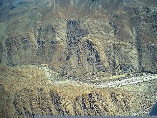
At the east end of the canyon, looking out to Punta Final:
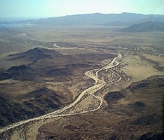
The end of the bulldozed road, 2 miles east of Mision Santa Maria:

|
|
|
Ken Cooke
Elite Nomad
Posts: 8971
Registered: 2-9-2004
Location: Riverside, CA
Member Is Offline
Mood: Pole Line Road postponed due to injury
|
|
Thanks for the photos, David. They lend a great perspective of the terrain.
|
|
|
TMW
Select Nomad
Posts: 10659
Registered: 9-1-2003
Location: Bakersfield, CA
Member Is Offline
|
|
| Quote: | Originally posted by steekers
I know David K has some aerial of Santa Maria and the canyons close by.
Any other Nomads have some good aerials?
As part of my Easter break, I am planning to fly into several airstrips in that area. While I am airborne, I will try and get some pics of the
canyons. |
Make sure the airstrip is not cut. The Mexican government has been cutting a lot of the dirt strips to prevent drug runners from landing.
|
|
|
David K
Honored Nomad
Posts: 65590
Registered: 8-30-2002
Location: San Diego County
Member Is Offline
Mood: Have Baja Fever
|
|
The old El Marmol airport has been ditched... however, on GoogleEarth... go north about 5 miles and see a runway at the end of a road... We drove out
there and saw it... after visiting El Volcan http://vivabaja.com/marmol
See this new post of those airstrips: http://forums.bajanomad.com/viewthread.php?tid=37821
[Edited on 3-24-2009 by David K]
|
|
|
David K
Honored Nomad
Posts: 65590
Registered: 8-30-2002
Location: San Diego County
Member Is Offline
Mood: Have Baja Fever
|
|
Bumping this one to help someone find it who emailed me asking about the hike to Mision Santa Maria and the canyon pools.
|
|
|
| Pages:
1
2
3 |


