David K
Honored Nomad

Posts: 65549
Registered: 8-30-2002
Location: San Diego County
Member Is Offline
Mood: Have Baja Fever
|
|
1967: L.A. Bay trip report ...
This article originally was posted on Amigos de Baja... it gives a pretty good look at the way it was driving in Baja then... and how much Baja meant
to me as a kid, as well!
---------------------------------------------------------
All these wonderful Bahia de los Angeles stories have me thinking back when I was almost ten years old, in the summer of '67 (my 'wonder years'). My
parents and I had been traveling/four wheeling in Baja for two years and all of us were totally entranced by the rugged and beautiful peninsula.
The previous summer (1966) we made the great journey from Tijuana to Cabo San Lucas (took two weeks, with 800 miles on dirt). We didn't detour to L.A.
Bay then, saving it for next year!
Our route to Bahia was to go down from Mexicali & San Felipe. Even though the 'toughest' road in Baja was this way (Puertecitos to Gonzaga), that was
better than going through the dust bowl at Laguna Chapala on the main transpeninsular road, which we experienced the previous year. That talcum powder
fine silt, one had to plow through before the dry lakebed, was the worst part of the 1000+ mile trip!
The 'Gonzaga Grades' (as we called them) south of Puertecitos were a great challenge, even with low range four wheel drive... Today's graded dirt road
people think is bad is a super highway compared to the original road over the volcanic ridges. Parts of it can be seen from the present graded road on
opposing canyon walls.
In 1967, San Felipe's main street was dirt and a devastating chubasco would (soon after our trip) do terrible damage. We stocked up on bolillos at the
bakery and headed south. The road was graded to Puertecitos and stayed inland from the coast passing through the sulfur mine valley.
Puertecitos was then a small resort settlement with a cafe, motel rooms, airstrip, and some wonderful albeit stinky hot springs at the water's edge.
It was here, in 1965, patrons informed my dad that this was the 'end of the road'. My dad (that year) made it to Gonzaga Bay, anyway...towing a tent
trailer! A determined dentist and a Jeep Wagoneer is a combination NOT to be underestimated...LOL!
Leaving Puertecitos we engaged 4WD Low Range and crawled the Jeep over each of the six extremely steep volcanic staircases ('Gonzaga Grades' my folks
called them) that ended at El Huerfanito. A small cafe was built there, near the shore across from the Little Orphan island (El Huerfanito). Many
children appeared and my parents had brought hard candies (dulces) for them... much appreciated!
The road alternated between flat and small grades as we continued on. The next campo was 'Okie Landing', a sport fishing camp with some palapas and an
ice house built in a cave.
Finally, Bahia San Luis Gonzaga came into view. The first time we came here, was in '65 and stayed near the campo now called Alfonsina's... back then
I don't recall the official name, if it was different.
From Gonzaga we headed south through the boulders of Las Arrastras and water filled Calamajue Canyon to El Crucero on the transpeninsular main road.
The main roads then were just two deep parallel ruts in sand or rock terrain. You could almost let go of the steering wheel and the ruts would steer
the Jeep for you! In a few miles we turned off the main Baja road and headed for L.A. Bay.
At Desengano we stopped to examine the several adobe buildings from this 1930's gold mine. Several more miles pass and just like today, the first
view of the 'Bay of Angels' was breathtaking!
The town of L.A. Bay was only about 100 people who mostly worked for Papa Diaz or hunted turtles... Casa Diaz was THE place, the ONLY place for
tourists in 1967!
Casa Diaz was operated by 'Papa' (Antero) and Cruz Diaz. Now, the problem was Mrs. Diaz did not appreciate being called 'mama' by anyone but her own
children. However, where there is a 'papa' then there must be a 'mama', right? This issue was documented in many publications of the time. In more
recent times I heard Cruz relented and accepted the name 'Mama Diaz' with a smile!
Cruz was a famous for her turtle steaks, as she ran the kitchen at Casa Diaz. Pilots would make great detours in flight plans should an opportunity
for a meal prepared by Senora Diaz arise! Most customers at Casa Diaz were pilots and their passengers. The closest paved road was just north of
Colonet, 280 miles away. Jeep and motorcycle clients were rare.
The L.A. Bay airstrip's south end was at Casa Diaz, a collection of cinder block groups of cabins, where pilots would taxi their planes up to and park
in front of their room. Much like autos at a motor lodge.
Legendary Baja pilot, Francisco Munoz, operated a small airline called 'Baja Air Service' that flew from Tijuana to L.A. Bay, Mulege, and Puerto
Vallarta... an airline ahead of its time. My dad flew with Munoz over Baja in the co-pilot's seat, that year!
Casa Diaz may have been the first time anyone showered in solar heated water, another innovation in Baja. The only trick was to shower in the
afternoon, because without a day's sunlight, any other time would be less than ideal water temperature!
In the summer, it was way too warm at night to sleep in the rooms. So, every room had cots on the outside for sleeping in the open... that was great!
About ten o'clock, Papa would shut off his generator (the town's only source of electricity), after a couple of warning brown outs, to give you time
to light lanterns. Then a billion stars would grab your attention. No finer sleep at any hotel could be had then that system at Casa Diaz...under the
stars!
Papa Diaz had a big yacht anchored off shore. He took groups fishing on it. The yacht was called the 'San Agustin', I believe. If there was an
emergency, Papa would go to his yacht and use the HAM radio onboard. The U.S. Coast Guard could fly a helicopter down, if needed to rescue an injured
person.
The kids at L.A. Bay had an interesting toy. It was a kind of a Baja version of a cap gun. The toy was the invention of Dick Daggett (Jr.), who was
the town mechanic. Several families in Baja have English last names. Dick's father jumped ship in the 1890's, hid in a cave until the ship left and
stayed in Baja. More on the Daggetts in another article... Anyway, using discarded spark plugs, a large nail, and a string, theses 'cap gun toys' were
made. The ceramic removed, hollowed out spark plug core was where a wooden match was inserted and twisted, leaving the sulfurous tip behind. The nail
was then inserted. A loop of string attached the nail to the spark plug, and then holding the loop one would slam the head of the nail against a wall.
The point of the nail ignited the match head, and BANG!!! It was quite effective. We considered marketing the product!
One other family was brave enough to drive into L.A. Bay that summer. It was the Anderson family of Valley Center. Their bodies and vehicle showed
clearly they came south from Ensenada as the Laguna Chapala dust was all over them! They were in a Land Rover with two boys a couple years older than
my 9 1/2 years of age. I had a Briggs and Stratton powered mini bike and the two Anderson boys were very interested in it. They had a room at Casa
Diaz at first, but then moved out to the sand point to camp (where the light house is now). My dad drove us out to party with them one day, on the
sand point. They were quite surprised that we had ice and my dad could whip up some ice cold adult drinks!
The Anderson's note in Diaz' logbook read: "We came over in a Land Rover. The road was rough, but the Rover is tough... We whaled our tails!"
Some seven years later, I took a world history class in high school. The teacher would mention Baja California, he had a Land Rover... yep, that's
right, talk about a small world! I started to describe that trip of '67... it was really shocking how we ended up re-meeting. He specially remembered
my dad's icy c-cktails! I think I got an A in Terry Anderson's world history class! Viva Baja!
That was quite a trip, 35 years ago... and very fresh in my mind. Getting there was only HALF the adventure!
The return trip abruptly changed, just a mile or two from Casa Diaz. For reasons I won't describe, my dad decided not to return at that moment! My mom
was already 'Baja Proven' and didn't need any man to drive us back... So, she and I continued north. We got to the old mill ruins at the edge of
Calamajue Canyon, where we spent the night.
The next day, just a few miles north, we ran out of gas in the Wagoneer? or something stalled us. My mom was not worried, as we were aware of a Baja
tour 4WD Carryall and Nissan Patrol support vehicle somewhere behind us. My mom set up our bridge table and prepared slices of ice-cold watermelon to
serve our rescuers! Soon, the 4WD 'bus' arrived and out came the passengers (old ladies mostly). Their air conditioning was on the fritz... and it was
well over 100?! One of the tour passengers took my mom aside, and begged her to take her as a passenger, offering large sums of money, even! I guess
this early Baja tour company was less than prepared for the toils of the land. My mom declined preferring the uncomplicated status quo. Watermelon was
a hit, we got some gas or whatever was needed and headed for Alfonsina's. Alfonsina's had a few rooms for rent back in those days, so there we stayed
the second night out.
Back at Casa Diaz, my dad waited for Captain Munoz to return for a flight out... this is when my dad got to be co-pilot of Baja Air Service!
My dad hopped on Capt. Munoz' plane on its southbound leg to Mulege and Puerto Vallarta. I think Munoz gave my dad a tour of Puerto Vallarta before
the return flight. Anyway, on the return flight north, Francisco Munoz invited my dad to sit up front, in the co-pilots chair. Concerned over my mom's
decision to drive north over the dreaded 'Gonzaga Grades', Captain Munoz deviated the normal route to Tijuana and flew up the gulf coast to try and
spot my mom and I.
Mom and I headed towards Puertecitos in the Wagoneer. We pulled off to look at a water hole, 'Agua de Mezquitito'. The area was thick with quail.
Climbing over the grades, we came upon a Mexican supply truck stalled near the summit. We stopped to offer assistance, and the driver quickly placed
rocks behind our Jeep's tires, should we roll back to certain death! All along the steep grades between Puertecitos and El Huerfanito were crosses and
wrecked cars and trucks in the canyons below. Brake failures, 2WDs losing traction, and simply mis-steering on the narrow trail were the likely cause
of those tragedies.
The completion of Highway One, in Dec. '73 changed traffic greatly to Gonzaga Bay. No longer was any maintenance performed south of Puertecitos, as
all commercial traffic came in from the south after '73. The new graded road (south of Puertecitos) was blasted through in 1985-86.
Well, mom and I made it to Puertecitos and rented a room for the night. That was when I first enjoyed the famous sulfur hot springs at the water's
edge. Timing is critical to enjoy the pools that are totally covered at high tide and too hot if low tide has kept the sea water away too long. Yes,
you will smell like a rotten egg, but your aches and pains of the harsh road will be gone!
We were never spotted from the air and made it back safely. In the end, both my mom and dad had interesting stories to compare, and I had gained some
new great memories of Baja in the Golden Years! Thank you Ed and Lynn for giving me Baja Fever
[Edited on 11-10-2004 by David K]
|
|
|
Mike Humfreville
Super Nomad
Posts: 1148
Registered: 8-26-2003
Member Is Offline
|
|
Good Stuff David
We were all having lunch at the northernmost Grosso ranch in Laguna Chapala a while back and I was talking with the daughter of Sr. Grosso and asked
when the newer cutoff, through Chapala to the east coast road, had been put through, allowing us to no longer get bogged down in the Calamajue trek.
She told me that the road to Gonzaga Bay had originally been across the dry lake. She said that the Calamajue road had been put through later and for
a while the Chapala road was not used.
The first time I personally traveled the east coast route was about 1969 and the road, going north, left Hwy 1 at El Crusero, about 20 miles north of
the Bahia de Los Angeles junction. There was an old and very pink ranch there with a small water well and I shared a meal with the family. The
Chapala road was nowhere to be seen until many years later (maybe around 1980??) when it was "re-opened" according to Mrs. Grosso.
The Chapala route, as many of us know, is a relatively good road. The old road through the Calamajue canyon and stream that pretty much ends (or
starts, depending on your direction) at Calamajue ruins, is 17 miles of beauty unique to Baja but it's a tough one.
|
|
|
David K
Honored Nomad
Posts: 65549
Registered: 8-30-2002
Location: San Diego County
Member Is Offline
Mood: Have Baja Fever
|
|
Mike, grab your Gerhard & Gulick 'Lower Ca Guidebook'. Check the edition date (1970, 67, 64, 62, 58, or 56). The later four editions all had the same
'62 maps. Look at the map 7. If you don't have the 'Baja Bible' handy, then go to my web site and on the home page is a link to Gulick's 1962 maps
(pdf)... works real cool, you can zoom in on any of them.
You will see in '62 there were roads from both Rancho Chapala and via Calamajue canyon to Gonzaga. They joined near Las Arrastras, with a cross-over
road just south (where Coco lives today).
The information I have says that Arturo Grosso accepted the governor's challenge and with dynamite, built the first road to San Felipe from his Rancho
Chapala, winning the prize of 50,000 pesos or some such number. This was in the early '50's.
The section from Chapala to today's Coco's Corner was so rough most traffic used the Calamajue canyon route until the graded road was put in (over
Grosso's road) and on to Puerto Calamajue, in the early 1980's.
I have been in the Calamajue canyon 'water road' in '67, '74, '75, '79, and '02. There's a photo of my Subaru in the canyon in 1979 on my Album web
site.
A really neat place!
|
|
|
Bob H
Elite Nomad
Posts: 5867
Registered: 8-19-2003
Location: San Diego
Member Is Offline
|
|
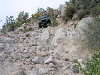
Gonzaga Grades
Possibly this was part of the "Gonzaga Grades" or maybe "Tres Maria" section. What's left of it anyway. Looks harsh, huh? Bob H
The SAME boiling water that softens the potato hardens the egg. It's about what you are made of NOT the circumstance.
|
|
|
Barry A.
Select Nomad
Posts: 10007
Registered: 11-30-2003
Location: Redding, Northern CA
Member Is Offline
Mood: optimistic
|
|
Bob H-----that is almost exactly what it looked like when in use, and I remember that particular stretch. I went over it twice, once in l958 and again
in 1959, the first time in a WW-II army ambulance, and the second time in a VW bus. It was hairy, and the bus actually did better than the 4x4
ambulance. It was so steep that the ambulance ran out of low-end power often. The bus, due to its amazing suspension, could be powered up the grades
at a pretty good clip and thus we were able to just sorta bull ourway thru the bad stretches. David is so correct---there were many wrecks down in the
side canyons. The first time we went thru in the ambulance we had a friend in a regular military jeep along with us. He panicked on one of the steep
pitches, started spinning their tires, slipped backwards and rolled the jeep. They were only cut up and bruized, and the jeep had only minor damage,
but they turned around in disgust and got the heck out of there. They were so lucky that they did not go over the side. They were really shook up.
We continued on our way but finally gave it up near the last of the 6 grades as the ambulance was beginning to fall apart---clutch going out, and
stuff. Back we went to Puerto Citos. The next year we made it all the way to Gonzaga in the VW bus, no real problems except being stuck in the sand
dunes behind south Gonzaga Bay for a day and a half, but that is another story. Without ample supplies of Bacardi we probably would never had made
it. Those were truly the "golden days" of Baja, as David K says. The new road is a pussy-cat!! Barry A.
|
|
|
David K
Honored Nomad
Posts: 65549
Registered: 8-30-2002
Location: San Diego County
Member Is Offline
Mood: Have Baja Fever
|
|
Yes Bob, that is the top of one.. In fact there was a time before that cut was made that that grade was even steeper. Erle Stanley Gardner called it
the Point of the Picture of Death because of a religious pray booth picture. The supply trucks would stop and pray they made it over the grades... It
was THAT dangerous! The three Marias is somebody's name for the same area. I think there were at least 6 bad grades. Cliff Cross illustrates them with
numbers in his book. Later I will scan his map and post it here.
Barry, awesome story! After '73 they got much worse as all traffic came in from the new highway and didn't use that road anymore. My last time was in
'79... VERY BAD!
|
|
|
Mike Humfreville
Super Nomad
Posts: 1148
Registered: 8-26-2003
Member Is Offline
|
|
I made the trip a number of times in the late '60's - early '70's. I always felt like I had really accomplished something until I ran into a couple
driving some small 2WD sedan at the top of the worst grade. Wow.
I don't know how many of us have taken the old road (1960's vintage) between Bahia de Los Angeles and San Francisquito. That was a nice road, winding
through elevated plateaus and overlooking the Sea of Cortez from time to time, but there was one MAJOR bad place as you climbed out of the wash going
south and nearing the plateau on which San Francisquito is situated. It was composed of 12" rocks and damned near vertical in places. I was driving
my TLC in 4WD low-low and barely made it up. Then I had to turn around and come back down for my pals in a 2WD pickup and tow/winch them to the top.
That was a 500 yard stretch, but was as bad in that short drive as the San Felipe - Gonzaga road was long.
|
|
|
Mike Humfreville
Super Nomad
Posts: 1148
Registered: 8-26-2003
Member Is Offline
|
|
"were tough..."?? "OLD"??? Whats that old stuff all about???? Hell, I was there the last time Tres Virgenes erupted. Some of those cave paintings
were started by yours truly. They were originally mildly erotic. I have since discovered boxed wines and forgotton what erotic was all about anyway.
Good thread. I know that many of us made that same trip.
|
|
|
David K
Honored Nomad
Posts: 65549
Registered: 8-30-2002
Location: San Diego County
Member Is Offline
Mood: Have Baja Fever
|
|
Cliff Cross' 1970 Map of the Gonzaga Grades
Here is a close up of the grades south of Puertecitos on Cross' map
|
|
|
Mexray
Super Nomad
Posts: 1016
Registered: 8-30-2002
Location: California Delta
Member Is Offline
Mood: Baja Time
|
|
Wow, how I like a good Baja story...
...it's got all the right stuff...danger, breath taking scenery, new friends, mystery, Baja breakdowns, and of course, Ice cold drinks!
Thanks David...
According to my clock...anytime is \'BAJA TIME\' & as Jimmy Buffett says,
\"It doesn\'t use numbers or moving hands It always just says now...\"
|
|
|
PabloS
Nomad
Posts: 187
Registered: 4-8-2003
Location: North central AZ
Member Is Offline
|
|
We used to travel Tres Marias in our dune buggy, late 70's

Always a thrill 
|
|
|
David K
Honored Nomad
Posts: 65549
Registered: 8-30-2002
Location: San Diego County
Member Is Offline
Mood: Have Baja Fever
|
|
You got it Pablo! Those were the days! I hope no Nomad ever complains about how bad today's road is south of Puertecitos, now that they have some
perspective!
Thanks Stephen for the nice words!
|
|
|
Barry A.
Select Nomad
Posts: 10007
Registered: 11-30-2003
Location: Redding, Northern CA
Member Is Offline
Mood: optimistic
|
|
David is right---the road got worse in the '70's
My God, Pablo I cannot believe how bad the road got after I went over it in the late '50's. That is horrible----I suspect that only a dune buggy or a
tricked out rock climber could get over it then. I don't think that any of us thought we were particularily "tough" in those days----it was all just
a fantastic adventure! I remember when the road was still being used commercially there were individuals that lived along the 6 grades in rock
windbreaks. They maintained the road by hand. We all gave them donations, and the truckers did too. It was their only income, as far as I know. At
the top of several grades were shrines where you gave thanks to the Lord for your success, if you had any, or for your life if your rig went over the
side.
As for being ancient now----well, that is a relevant term----I sure do not remember seeing Tres Virgines erupt, as Mike claims, but they may have been
still warm to the touch. The caves that Mike refers to were virgin when I saw them--no grafitti at all, but they were handy for shacking up in, so
maybe that is what Mike is referring to, and he just had to express himself by painting the murals. He has always been more artistic than I.
Thanks David for the Cliff Cross map---I too have that book. It is a hoot!
I have not ever seen the road to Mission Santa Maria de Los Angeles, but from David K's pictures I suspect that it is even worse than the Tres Marias.
Want to try that one, one of these days. Barry A.
|
|
|
David K
Honored Nomad
Posts: 65549
Registered: 8-30-2002
Location: San Diego County
Member Is Offline
Mood: Have Baja Fever
|
|
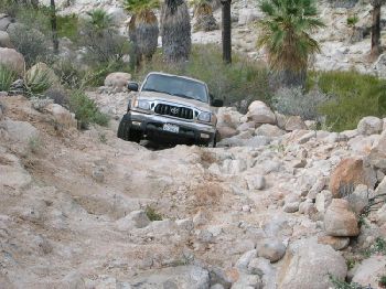
You mean this???
The 'Widowmaker' on the road to Santa Maria!
|
|
|
David K
Honored Nomad
Posts: 65549
Registered: 8-30-2002
Location: San Diego County
Member Is Offline
Mood: Have Baja Fever
|
|
Going down wasn't so bad... It is when you leave Mision Santa Maria and have to climb back up the Widowmaker that gets your heart pounding!
|
|
|
|


