| Pages:
1
2 |
Bajatripper
Ultra Nomad

Posts: 3152
Registered: 3-20-2010
Member Is Offline
|
|
A deep hole at Laguna Chapala
I don't find this hole interesting enough to start a thread on it, but a fellow Nomad did and asked that I post it.
A little background
In the 1940s-60s, my stepfather did field work in many then-remote regions of Baja. On one of his trips into the Vizcaino Desert in the 1940s, he came
across an American geologist who said he was working for Pemex, doing exploratory work for the Mexican oil company. Among the things they did was
drill test wells (of course).
In 1963, my family camped a couple of weeks on the southwestern shore of Laguna Seca Chapala while my stepfather did some investigating in the area.
On an outing not too far from our camp, my mother Bajalera stumbled on what seemed to her at the time to be a bottomless hole in the dry lake floor.
It likely isn't a ranch well, since the only ranch that I'm aware of in the "olden days," Arturo Grosso's (Anita [Mama] Espinoza's brother) Rancho
Laguna Chapala, was on the north shore of the "lake."
After discussing it with her husband, it was theorized that it was probably one of those wells drilled in the 1940s, just left uncovered for any old
cow to fall into.
Over the years, we had poked around the area looking for the hole Bajalera remembers, mostly to make her happy. We never located it. That is, until
our most recent trip north. We meandered our way out to the lake as darkness set in, looking for a suitable place to camp. We found a promising spot,
which I scouted in the moonlight, flashlight in hand. A mound of dirt caught my attention and I walked around it a bit before setting up camp nearby.
It seemed to me that the mound had to be man-made. The next morning, my wife found the hole from which the mound had been made. It's probably the same
hole Bajalera found in 1963, since we were but 50-60 yards from the old campsite.
On a trip to the cave painting region around Rancho Santa Marta north of San Ignacio, I came upon a similar, very deep hole right next to the road
before it enters the narrow canyon. There is more than one way to Santa Marta, so it is possible to get to the historic ranch and not pass by the
hole. But if you do see it (it's on the right side of the road), be careful. That hole makes my legs go weak.
For the record, that geologist long ago supposedly told my stepfather that the Vizcaino Desert is rich in oil.
Anyway, here are a couple of pictures of the hole at Laguna Chapala. For you, David.
The "discoverer" posing by her find.

I apologize for the poor angle, the photo doesn't do it justice. My wife refused to hold my hand while she leaned out to snap a better photo.

[Edited on 1-19-2012 by Bajatripper]
There most certainly is but one side to every story: the TRUTH. Variations of it are nothing but lies.
|
|
|
mooose29
Nomad
Posts: 201
Registered: 10-1-2008
Location: Encinitas/Punta Chivato, Rancho Partera
Member Is Offline
Mood: All Smiles
|
|
It would be interesting to know just how deep the hole is, any guesses out there?
|
|
|
redhilltown
Super Nomad
Posts: 1130
Registered: 1-24-2009
Location: Long Beach, CA
Member Is Offline
|
|
"makes my legs go weak"....man, you got that right!!!!!!! You don't get many mistakes with these types of mines/holes...I hate em! Interesting
report!
|
|
|
surfer jim
Super Nomad
Posts: 1891
Registered: 8-29-2003
Location: high desert
Member Is Offline
|
|
Narco tunnel entrance....?
|
|
|
mtgoat666
Platinum Nomad
Posts: 21055
Registered: 9-16-2006
Location: San Diego
Member Is Offline
Mood: Hot n spicy
|
|
| Quote: | Originally posted by Bajatripper
A deep hole at Laguna Chapala |
the hole diameter seems a bit too large to be an oil exploration well... given large diameter, perhaps was a exploratory mining excavation? or could
have been someones attempt at a hand dug water well
|
|
|
Pompano
Elite Nomad
Posts: 8194
Registered: 11-14-2004
Location: Bay of Conception and Up North
Member Is Offline
Mood: Optimistic
|
|
My guesses are:
A hand dug water well...or maybe a combo geological boring/archaeological dig (there are many in the Lake Chapala region). Both could have been done
with a windlass, although at great risk of a cave-in with no shoring. Geological boring would be looking for sediment layering, thus the vertical
shaft. A wild shot, though. Water searchers, most likely
Around 1976-77 Manuel Diaz dug a 90ft hole looking for water that myself and Blackjack found by water-witching the area on his property. He used a
windlass to pull up the excavated dirt...no shoring..nada...looks pretty much like this photo. A very risky business.
The water supply he found was insufficient for his use...and the hole remains there today...hopefully still covered.
[Edited on 1-20-2012 by Pompano]
I do what the voices in my tackle box tell me.
|
|
|
David K
Honored Nomad
Posts: 65549
Registered: 8-30-2002
Location: San Diego County
Member Is Offline
Mood: Have Baja Fever
|
|
Thank you Steve!
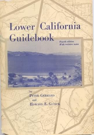
As for the Vizcaino oil explorations, from the Lower Californina Guidebook:
Pg. 130) A wide, hard-surfaced road leaves Guerrero Negro in an easterly direction.
5.3 miles (from Guerrero Negro): The "coastal route" followed here branches to the right. This is the bulldozed road constructed by Petroleos
Mexicanos ('Pemex'), the government oil monopoly, about 1959 when exploring for oil in this area.
Pg. 132, (35.2 miles from Guerrero Negro) ... Going right on this road takes one to its end at the abandoned Pemex camp, 9.2 miles.
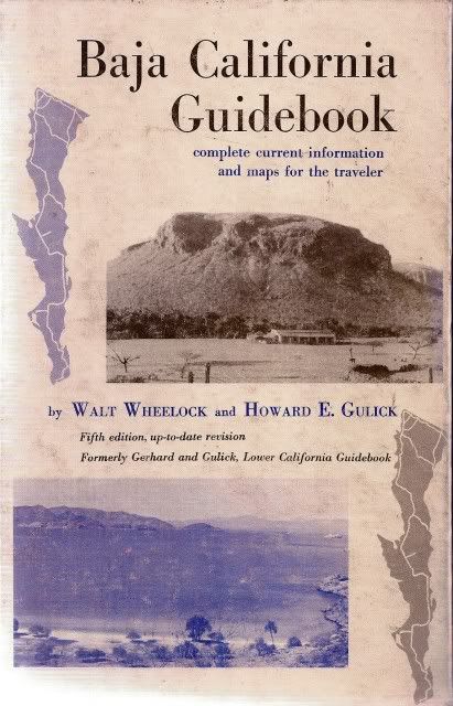
(The Lower California Guidebook by Gerhard & Gulick is a fanatastic look at Baja as it was in the 1950's and 1960's. An updated version in 1975
& 1980 by Walt Wheelock and Howard Gulick includes the new paved roads of the time along with much the same from older guide.)
|
|
|
willardguy
Elite Nomad
Posts: 6451
Registered: 9-19-2009
Member Is Offline
|
|
thanks david, just ordered the book.looks fun
|
|
|
Bajatripper
Ultra Nomad
Posts: 3152
Registered: 3-20-2010
Member Is Offline
|
|
Having read the comments, and actually "thinking" about it, one thing's for sure, I'm no Texan. You are are absolutely right, there's no way that
could be an exploratory oil well. Even non-Texans have seen those in movies many times over.
Thinking about it further, mining wouldn't make much sense, in the sense that you'd have to deal with who knows how many feet of unstable silt that
has piled up in that basin since erosion started its magical work before reaching any mineral deposits. It seems likely that if mining the silt were
the objective, they'd do "open pit" mining, not deep perforation.
Archaeology is also definitely out. I've seen them at work, and this isn't how they do things.
So I'm in agreement with those who say it was likely a local effort to find water. It is located in the area of the basin where fluids tend to
collect, but still has a little protection from some nearby dunes, a better ranch site than the old Rancho Chapala site.
Thanks for your contributions, all of you. I learned.
[Edited on 1-25-2012 by Bajatripper]
There most certainly is but one side to every story: the TRUTH. Variations of it are nothing but lies.
|
|
|
Bajatripper
Ultra Nomad
Posts: 3152
Registered: 3-20-2010
Member Is Offline
|
|
Thanks for the info on the updated version of G&G, David. I didn't know of its existence. I'll be sure to track on down, gotta have it.
There most certainly is but one side to every story: the TRUTH. Variations of it are nothing but lies.
|
|
|
Bajatripper
Ultra Nomad
Posts: 3152
Registered: 3-20-2010
Member Is Offline
|
|
| Quote: | Originally posted by mooose29
It would be interesting to know just how deep the hole is, any guesses out there? |
If it's any help (as I'm sure it is for those who have a good command of physics), I started counting as a rock cleared the entrance and got to "1001,
1002, 1" when the rock hit bottom with a thud.
It's been a few years so I don't remember by how much, but the hole on the way to Santa Marta was much more impressively deep. Those rocks slapped
around for a while before finding bottom
There most certainly is but one side to every story: the TRUTH. Variations of it are nothing but lies.
|
|
|
David K
Honored Nomad
Posts: 65549
Registered: 8-30-2002
Location: San Diego County
Member Is Offline
Mood: Have Baja Fever
|
|
| Quote: | Originally posted by Bajatripper
Thanks for the info on the updated version of G&G, David. I didn't know of its existence. I'll be sure to track on down, gotta have it.
|
Sure thing Steve... I got to meet Walt Wheelock in 1984 and he had already started talking about a newer (but smaller) guidebook from his La Siesta
Press called 'Baja Road Log' c1987. The Arthur H. Clark Company (the Guidebbok publisher) was closing shop.
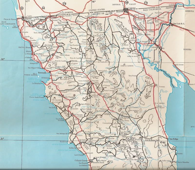
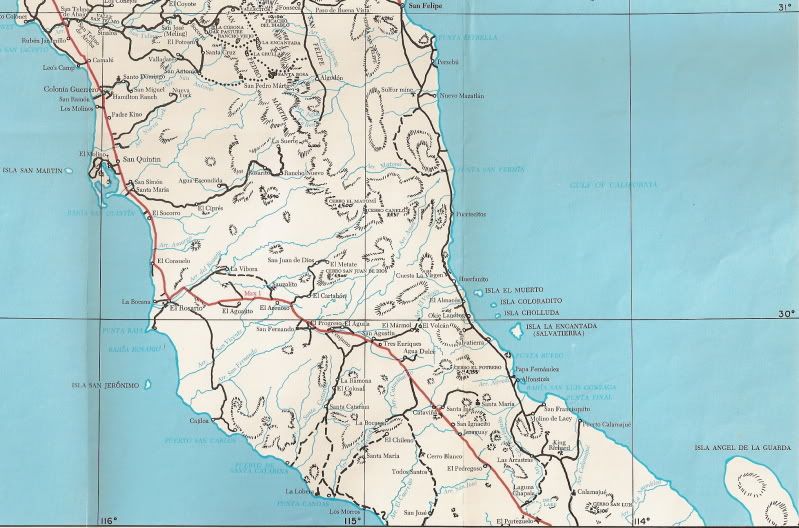
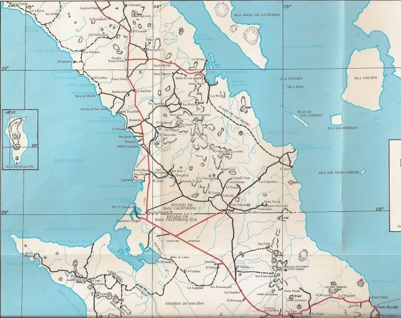
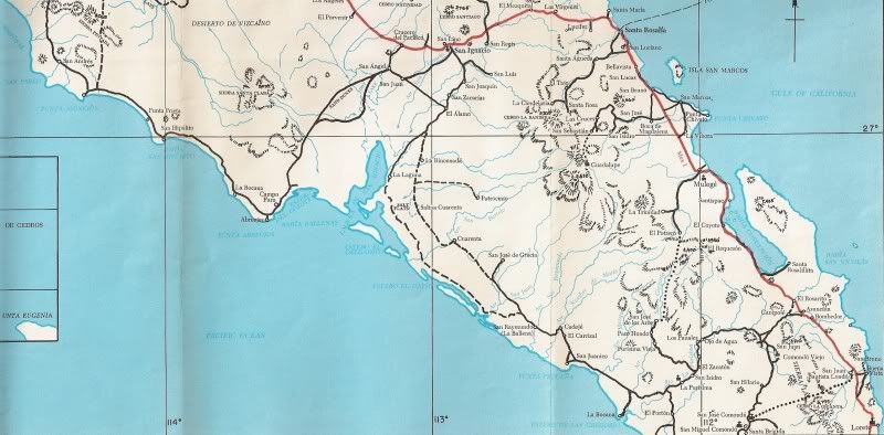
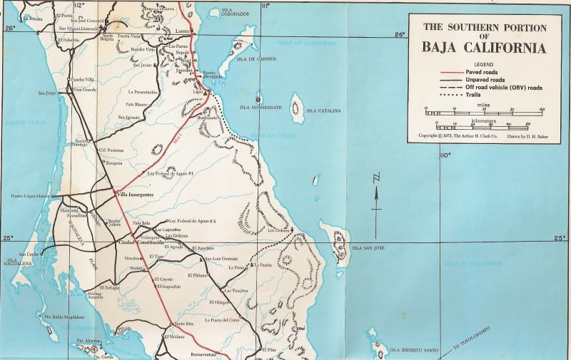
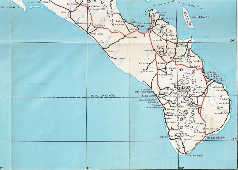
In the Baja California Guidebook (1975), instead of the sectional road maps as before, there is a pocket containing three folding maps... Not as
detailed, but it was one of the first accurate maps showing the true location of Hwy. 1... Have a look:
|
|
|
David K
Honored Nomad
Posts: 65549
Registered: 8-30-2002
Location: San Diego County
Member Is Offline
Mood: Have Baja Fever
|
|
Here is Walt's 1987 Baja Road Log:

|
|
|
J.P.
Super Nomad
Posts: 1673
Registered: 7-8-2010
Location: Punta Banda
Member Is Offline
Mood: Easy Does It
|
|
| Quote: | Originally posted by Bajatripper
Having read the comments, and actually "thinking" about it, one thing's for sure, I'm no Texan. You are are absolutely right, there's no way that
could be an exploratory oil well. Even non-Texans have seen those in movies many times over.
Thinking about it further, mining wouldn't make much sense, in the sense that you'd have to deal with who knows how many feet of unstable silt that
has piled up in that basin since erosion started it's magical work before reaching any mineral deposits. It seems likely that if mining the silt were
the objective, they'd do "open pit" mining, not deep perforation.
Archaeology is also definitely out. I've seen them at work, and this isn't how they do things.
So I'm in agreement with those who say it was likely a local effort to find water. It is located in the area of the basin where fluids tend to
collect, but still has a little protection from some nearby dunes, a better ranch site than the old Rancho Chapala site.
Thanks for your contributions, all of you. I learned. |
Having grown up in West Texas and worked in the oil fields in west Tx and the gulf of Mexico area,that hole has nothing to do with the oilfield , I
do agree it is probably a hand dug water well .
|
|
|
Vince
Nomad
Posts: 448
Registered: 10-17-2006
Location: Coronado
Member Is Offline
|
|
I'm glad I didn't fall into that hole when I drove across dry lake Chapala in about 1970. The silt was so fine that I had to keep the windshield
washers going on the VW van and the air filter plugged up. That was where the road took you then.
|
|
|
David K
Honored Nomad
Posts: 65549
Registered: 8-30-2002
Location: San Diego County
Member Is Offline
Mood: Have Baja Fever
|
|
| Quote: | Originally posted by Vince
I'm glad I didn't fall into that hole when I drove across dry lake Chapala in about 1970. The silt was so fine that I had to keep the windshield
washers going on the VW van and the air filter plugged up. That was where the road took you then. |
Even in 1973, before the highway was paved... the detour along the base of the new road went through the famous Chapala dust (silt)!:
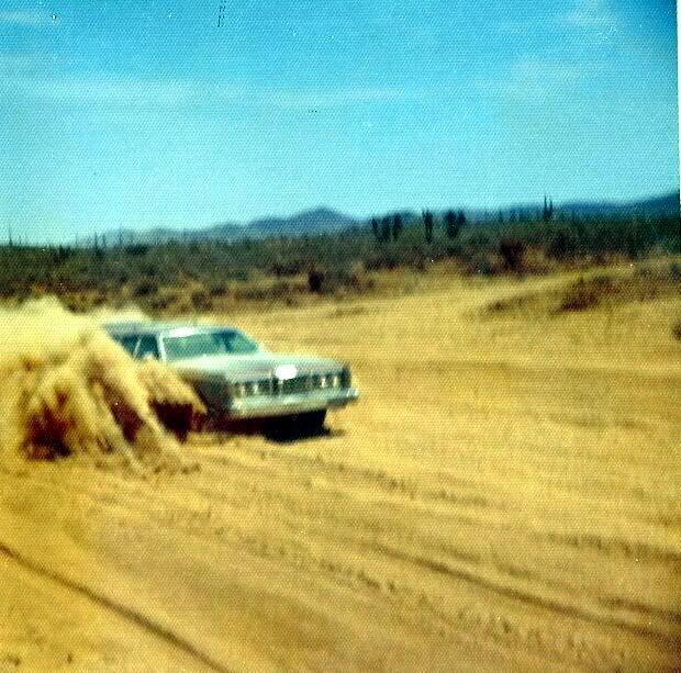
We had been through Laguna Chapala originally on our 1966 trip to the tip, and all trips south after that were made on the gulf road (yes, Gonzaga's
grades were easier to deal with than Chapala's dust)! In 1973, my dad traded his 4WD for that Ford LTD Wagon... We heard the pavement was almost done
(in June, '73) so we took a chance the street wagon could handle what little remained of the old road for a trip to Loreto!
We were surprised that pavement ended so soon after El Rosario (near the Mision San Fernando road/ El Progreso) and we were off the new roadbed and
onto the old Baja 1000 road in 26 miles, by Agua Dulce... and on the old road all the way to the Chapala valley (50 miles) where we met road crews
coming north. Pavement began again in sections around Punta Prieta, but wasn't solid until about Villa Jesus Maria.
[Edited on 1-19-2012 by David K]
|
|
|
willardguy
Elite Nomad
Posts: 6451
Registered: 9-19-2009
Member Is Offline
|
|
so how did the LTD wagon do?
|
|
|
David K
Honored Nomad
Posts: 65549
Registered: 8-30-2002
Location: San Diego County
Member Is Offline
Mood: Have Baja Fever
|
|
| Quote: | Originally posted by willardguy
so how did the LTD wagon do? |
Fine, once we dumped all the dust out of the air filter!
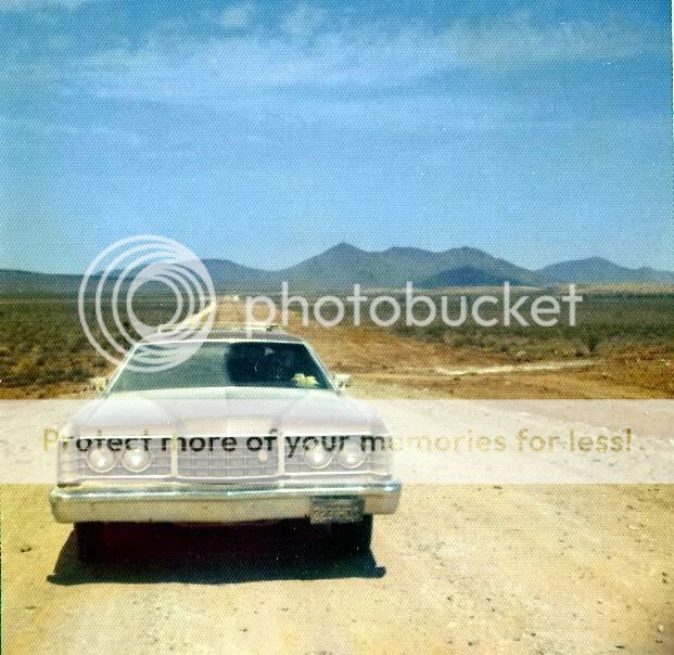
Here is my dad and I at the pass south side of the Chapala valley, congratulating each other on making it through the Chapala dust bowl!:
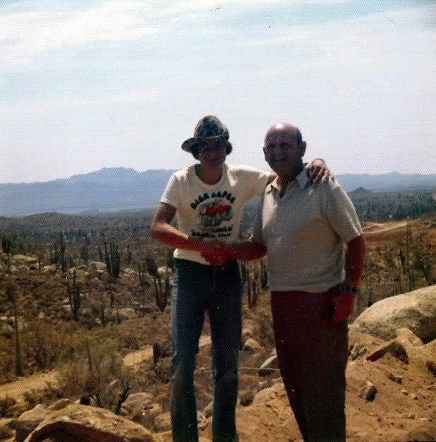
Skinny me at 15, with Dick Cepek Baja Proven shirt on (I would meet Dave Deal who did that cartoon 28 years later).
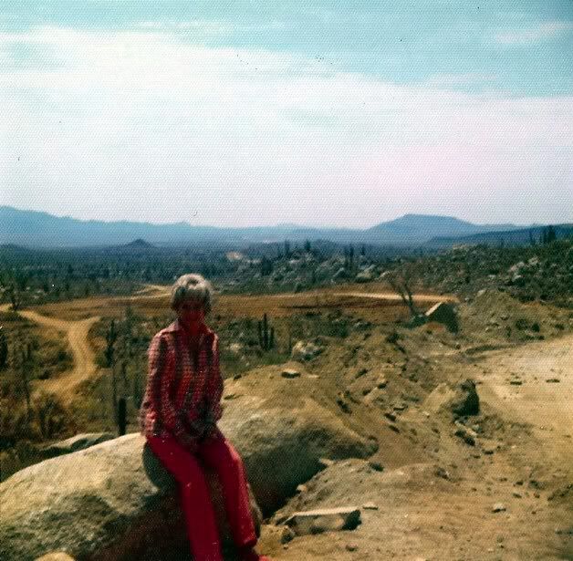
Here's my mom... you can see Hwy. 1 under construction heading south towards El Crucero & Punta Prieta:
[Edited on 1-20-2012 by David K]
|
|
|
willardguy
Elite Nomad
Posts: 6451
Registered: 9-19-2009
Member Is Offline
|
|
hey! me and your dad go to the same barber
|
|
|
David K
Honored Nomad
Posts: 65549
Registered: 8-30-2002
Location: San Diego County
Member Is Offline
Mood: Have Baja Fever
|
|
He never got a discount either!
|
|
|
| Pages:
1
2 |


