David K
Honored Nomad

Posts: 65549
Registered: 8-30-2002
Location: San Diego County
Member Is Offline
Mood: Have Baja Fever
|
|
Baja, on Planet Earth (NASA PHOTO)
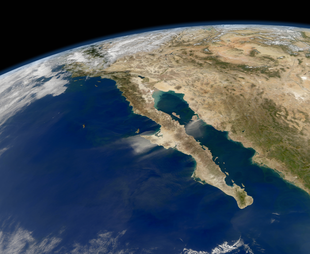
Taken from the AQUA satellite.
Here's the story from Gary Robbins of the U-T San Diego:
This image from the Aqua satellite shows dust being blown out to sea by powerful northeast winds. NASA NASA's Aqua satellite orbits Earth 14.5 times
a day, silently studying precipitation, evaporation and the water cycle as it loops around the planet. The satellite has photographed Baja California
many times. But this image, taken in November, is especially good, capturing the roughly 1,100 mile stretch from Tijuana to Cabo San Lucas. Baja looks
almost uninhabited in this photo, even though it has about 3.2 million people, slightly more than San Diego County.
Some regions of Baja have a Mediterranean climate. Other areas are desert. They're arid. But wind can blow hard throughout Baja. Here, you see dust
being blown from the mainland, across the Sea of Cortez, across Baja and out to sea. The winds shot out of the northeast, much like the Santa Anas do
in Southern California.
Aqua satellite NASA In releasing the image, NASA said, "The Ocean Color Team at NASA Goddard processes images like this to help assess the presence of
sediment and plankton in the sea. Dust storms interfere with that processing, as the sandy aerosols block much of the incoming sunlight and the
outgoing, reflected light.
"Dust storms can disturb human activity on land, but once they blow out over the Gulf of California and Pacific Ocean, they help fertilize the waters
with nutrients that promote phytoplankton blooms. In winter, the waters around Baja are often full of whales, as the largest creatures in the sea
often eat the smallest plankton."
[Edited on 1-21-2012 by David K]
|
|
|
mcfez
Elite Nomad
Posts: 8678
Registered: 12-2-2009
Location: aka BN yankeeirishman
Member Is Offline
|
|
I think I can see Shell Island...............:-)
That's a GREAT shot David!
Old people are like the old cars, made of some tough stuff. May show a little rust, but good as gold on the inside.
|
|
|
Ateo
Elite Nomad
Posts: 5955
Registered: 7-18-2011
Member Is Offline
|
|
cool info from Gary at the UT too!
|
|
|
Barry A.
Select Nomad
Posts: 10007
Registered: 11-30-2003
Location: Redding, Northern CA
Member Is Offline
Mood: optimistic
|
|
Wow, the "delta mud" from the Colorado river almost reaches Bahia San Luis Gonzaga!!!! (light green waters equal shallow water) That's a lot of
sediment, much of it from the Grand Canyon, I am thinking.
Barry
|
|
|
Udo
Elite Nomad
Posts: 6364
Registered: 4-26-2008
Location: Black Hills, SD/Ensenada/San Felipe
Member Is Offline
Mood: TEQUILA!
|
|
Thanks for sharing the information, DK...love the photo.
Udo
Youth is wasted on the young!
|
|
|
goldhuntress
Senior Nomad
Posts: 663
Registered: 1-28-2010
Member Is Offline
|
|
This shot was posted before http://forums.bajanomad.com/viewthread.php?tid=57362#pid6847... If you go there and click on the highlighted words there is a map in motion of
the sand blowing, kinda cool.
|
|
|
David K
Honored Nomad
Posts: 65549
Registered: 8-30-2002
Location: San Diego County
Member Is Offline
Mood: Have Baja Fever
|
|
Thanks gold..., I didn't see that one... I often don't open links but prefer to see the image already opened... it would seem other Nomads also
missed it earlier. It is a great photo worth repeating perhaps. What I like is that you see the curve of the earth's globe and Baja right below.
According to astronauts (I read years ago), the Baja peninsula is the most recognizable feature on Planet Earth!
|
|
|
bacquito
Super Nomad
Posts: 1615
Registered: 3-6-2007
Member Is Offline
Mood: jubilado
|
|
Interesting, thanks
bacquito
|
|
|
bajalearner
Senior Nomad
Posts: 670
Registered: 8-24-2010
Location: Tijuana
Member Is Offline
Mood: in search of more
|
|
It appears the land (peninsula) on the west coast of Baja, under the blowing sand, may have been formed by many thousands of years of this wind
condition.
|
|
|