| Pages:
1
2
3
4
..
9 |
Fernweh
Nomad

Posts: 444
Registered: 2-24-2011
Location: Centenario, BCS
Member Is Offline
|
|
I have to donate some ranch work at the Tres Virgenes area first - later part of April.
Then I could meet up in Loreto on the 30th, or already be camping at the beach in Aqua Verde by the palapa.
Stay for the night (or more), climb out the next morning and drive to Timbabichi for another camp out. My final destination is La Paz via the east
coast or Hwy 1 route.
Who likes to join and what are your plans/suggestions?
Karl
|
|
|
TMW
Select Nomad
Posts: 10659
Registered: 9-1-2003
Location: Bakersfield, CA
Member Is Offline
|
|
That would work for me.
|
|
|
Bajatripper
Ultra Nomad
Posts: 3152
Registered: 3-20-2010
Member Is Offline
|
|
At this point, works for us.
There most certainly is but one side to every story: the TRUTH. Variations of it are nothing but lies.
|
|
|
XRPhlang
Nomad
Posts: 111
Registered: 10-12-2007
Location: Central Coast
Member Is Offline
Mood: Taco me.
|
|
I wanna go.
|
|
|
TMW
Select Nomad
Posts: 10659
Registered: 9-1-2003
Location: Bakersfield, CA
Member Is Offline
|
|
Phil how you doin? This should be an exciting trip to places we've never been to. I'll probably stop by Mexicali on Sat. April 28th for the NORRA Tech
and contingency. Then head south to San Felipe and on to Cocos to watch the race go by on Sunday the 29th. Then head south to Loreto or Agua Verde to
meet up. Nothing firm yet until we all agree when and where to meet as we get closer.
|
|
|
XRPhlang
Nomad
Posts: 111
Registered: 10-12-2007
Location: Central Coast
Member Is Offline
Mood: Taco me.
|
|
I'm ready already. I'll hold a week open between 28th and Cinco de Mayo. Maybe I'll bring my bike and do side trips from Aqua Verde. What about a
trip out to mission Delores?
|
|
|
dtbushpilot
Ultra Nomad
Posts: 3297
Registered: 1-11-2007
Location: Buena Vista BCS
Member Is Offline
Mood: Tranquilo
|
|
Tom and Phil, looking forward to seeing you both and comparing stories about what you guys did with your share of the padre gold from the "lost
mission" adventure. I'll bring a picture of the new boat I bought.....sweeeet.....
"Life is tough".....It's even tougher if you're stupid.....
|
|
|
David K
Honored Nomad
Posts: 65549
Registered: 8-30-2002
Location: San Diego County
Member Is Offline
Mood: Have Baja Fever
|
|
| Quote: | Originally posted by XRPhlang
I'm ready already. I'll hold a week open between 28th and Cinco de Mayo. Maybe I'll bring my bike and do side trips from Aqua Verde. What about a
trip out to mission Delores? |
Wow, 10 months we have missed you here!!! Not since the Santa Isabel search in El Vocan... Hi XR!!
Did you think you could get out of writing a trip report (as DT has so far, too)??
Seriously, glad to see you alive and kicking amigo... and it is LOS DOLORES mission   
|
|
|
Hook
Elite Nomad
Posts: 9013
Registered: 3-13-2004
Location: Sonora
Member Is Offline
Mood: Inquisitive
|
|
Well, that should keep him away for another 10 months, David...........
|
|
|
XRPhlang
Nomad
Posts: 111
Registered: 10-12-2007
Location: Central Coast
Member Is Offline
Mood: Taco me.
|
|
Sorry about not writing a trip report. With all that gold we found, I figured it better to lay low for a while.
DT- I can haul your bike then you can drive your boat down to Aqua Verde.
DK- Don't listen to them. You're one of the reasons I like Baja Nomad. How 'bout some Los Dolores info.
|
|
|
TMW
Select Nomad
Posts: 10659
Registered: 9-1-2003
Location: Bakersfield, CA
Member Is Offline
|
|
There may be more gold to be found on the east coast of Baja Sur and we are the right group to find it.
|
|
|
motoged
Elite Nomad
Posts: 6481
Registered: 7-31-2006
Location: Kamloops, BC
Member Is Offline
Mood: Gettin' Better
|
|
DT's new boat...
David isn't sure if he will bring the new boat....or his older one????
Older boat with private skipper:

Newer boat (more power and cargo capacity):

 
Don't believe everything you think....
|
|
|
dtbushpilot
Ultra Nomad
Posts: 3297
Registered: 1-11-2007
Location: Buena Vista BCS
Member Is Offline
Mood: Tranquilo
|
|
"Life is tough".....It's even tougher if you're stupid.....
|
|
|
motoged
Elite Nomad
Posts: 6481
Registered: 7-31-2006
Location: Kamloops, BC
Member Is Offline
Mood: Gettin' Better
|
|
(Doing the Grand Canyon loop April 20 for a week...)
Don't believe everything you think....
|
|
|
David K
Honored Nomad
Posts: 65549
Registered: 8-30-2002
Location: San Diego County
Member Is Offline
Mood: Have Baja Fever
|
|
| Quote: | Originally posted by XRPhlang
Sorry about not writing a trip report. With all that gold we found, I figured it better to lay low for a while.
DT- I can haul your bike then you can drive your boat down to Aqua Verde.
DK- Don't listen to them. You're one of the reasons I like Baja Nomad. How 'bout some Los Dolores info. |
Thanks for that... and sure... be happy to!
Mision Nuestra Señora de los Dolores Apate was founded in 1721 on the gulf coast between Loreto and La Paz when the mission at Ligui (closer to
Loreto) was abandoned. Shortly after it was founded, the mission was moved a couple miles inland, in a canyon with good water supply. In 1741 the
mission was moved over 15 miles southwest to a visita of Dolores named 'La Pasion'. Some authors have called La Pasion a separate mission, but it was
still Los Dolores at its third and final location.
From my Baja Missions web page:
Originally established close to the gulf coast, Dolores was soon moved to this spot about 3 miles west. *In 1741, a third move was made to the Dolores
visita of La Pasion in the region called Chilla (see below).
Los Dolores is often called 'Dolores del Sur' because the Jesuits planned for a future mission of 'Dolores del Norte' (see Santa Gertrudis).
Photo taken from the ridgetop west of the mission.
This mission and San Pedro Martir are the only two not accessed by an automobile road.
GPS: 25°03'19.0" 110°53'03.3"
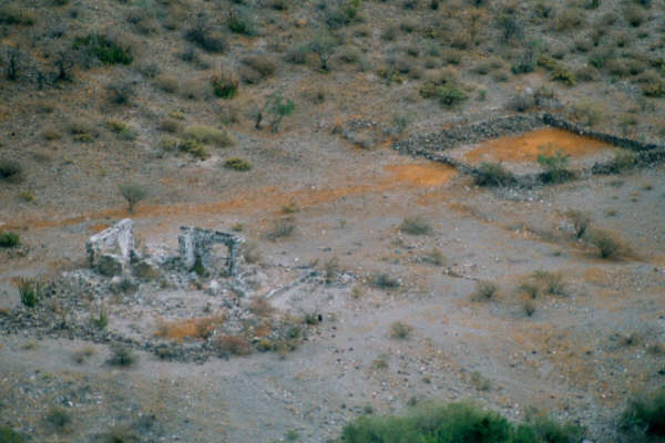
Jack Swords photo c
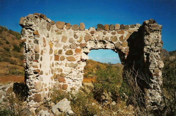
Close up photo of Los Dolores Apate by Kevin Clough in 1998
--------------------------------------------------------------------------------
Nuestra Señora de los Dolores Chilla 1741-1768
The final move for the mission of Los Dolores was over 15 miles to the southwest, in the region called Chilla by the Indians. This mission location
was usually called 'La Pasion', the name of the visita that was here. Some books list a seperate mission of 'La Pasion' instead of this being the
final location for Los Dolores. GPS: 24°53'14.4" 111°01'49.8"

Jack Swords photo c
In 1949, a Marquis McDonald photo:

------------------------------------------------------------------------------
The road to the coast just south of Los Dolores passes right by La Pasion. Another Dolores visita the became a seperate mission is San Luis Gonzaga,
not far from La Pasion.
Great stuff... enjoy your visit and take photos!
|
|
|
elfbrewery
Nomad
Posts: 350
Registered: 12-25-2006
Member Is Offline
|
|
I just looked at a couple possible trails that go out to Timbabiche via Google Earth. It seems that just east of El Manglito (?), where Google Earth
gives up on a road, you fall off the plateau. 40% grades?? Is this correct?
|
|
|
TMW
Select Nomad
Posts: 10659
Registered: 9-1-2003
Location: Bakersfield, CA
Member Is Offline
|
|
On Google Earth I don't see El Manglito. On GE the place called Tiguana is called Tijuana on the almanac. Probably a misprint in the one or the other.
Anyway I can follow the road all the way but there are some places along the wash that thr trail is not visible until you go further. I usuing a down
loaded version of Google Earth not the on line version.
|
|
|
Skeet/Loreto
Ultra Nomad
Posts: 4709
Registered: 9-2-2003
Member Is Offline
|
|
TW. If you use the Top Rim Road down be very careful and do it with two Vehicles and lots of SnakeBite Kits.
Up on the Rim and down about 50 feet along that Rim is some of the Best Rattlesnakes. And they are Thick.
Have a good Trip!
Skeet
|
|
|
elfbrewery
Nomad
Posts: 350
Registered: 12-25-2006
Member Is Offline
|
|
TW, with offline GE, are you able to flatten out your view so that you can look at the plateau from the east side and not just from overhead? You will
see what I mean about the drop. I have to correct what I said before. I drew a path for each of two roads I could see coming over that area and the
"slope" is over 40% (looking at vertical profile of the path). I'm not sure if GE means %slope or %grade, but slope can be measured in degrees. 40
degree slope is actual 84% grade. Nevertheless, it's twice as steep as the steep drive coming out of AV towards Constitucion.
I may be mistaken, but I believe I'm looking at the correct area.
Hope I'm wrong.
|
|
|
Fernweh
Nomad
Posts: 444
Registered: 2-24-2011
Location: Centenario, BCS
Member Is Offline
|
|
The drive out of AV is not that steep at all, a few quiet tight turns but otherwise no problems using the high 4x4 gear.
We always can send the guy with the most schnake bit kits out first to check the grade.....
Does everybody knows the AV playa with the palapa?
The access off the main dirt road is easily missed, I shall get the coordinates posted if that nice beach/camping spot is accepted as out meeting
point.
Karl
|
|
|
| Pages:
1
2
3
4
..
9 |


