| Pages:
1
2 |
TLBaja79
Nomad

Posts: 270
Registered: 10-17-2013
Member Is Offline
|
|
Camping Bahia Conception - Remote Camping
I'm planning a trip in March. Unfortunately its so far away but gives me plenty of time to plan and the weather should be just right.
I've been out of the Baja Camping mix for about 10 years but am getting back into it. From other trips in the last few years I've seen lots of
changes, so wondering about this area.
We plan to go camp in Conception Bay on the Penninsula part. Does anybody on here have information about camping out there?
I'm familiar with Baja dirt roads and camping Baja, but don't know that area at all. Just been a couple miles off the road a the south end of
Conception Bay, past the flats, but thats as far as I've been.
I have a 4x4 truck. We are looking forward to finding 'our own' beach for a few days. Is that possible out there? I'd imagine not many people are
out that way? Maybe just a fish camp or 2?
Any information you may have would be appreciated.
|
|
|
Pompano
Elite Nomad
Posts: 8194
Registered: 11-14-2004
Location: Bay of Conception and Up North
Member Is Offline
Mood: Optimistic
|
|
I've been out there several times since 1973. Used to go deer hunting with some locals. The peninsula is easily reached and explored with your 4X4.
There's a few fish camps scattered along it's bayside shores and also on the Cortez side. These are supplied with the fish camp guy's own 4X4's and
of course, their pangas.
The route is clearly marked, (mostly just follow the shoreline) but don't expect it to be smooth all the way. Recent storms will have had their
affect on the road's condition, but you know that already. I've driven a 25ft Minnie Winnie most of the way...and on other trips got stuck in my
CJ-5....it all depends on the washouts.
You can make it all the way to the last beach..Playa Domingo (Sunday Beach). Has a fish camp at one end and great sandy beaches in a semi-sheltered
bay. Good shelling and beachcombing..especially after a good northerly.
There are several things to see...Painted Canyon (rock drawings and old camp middens to explore), a couple older ranches (Baja Patty's Rcho Margarita
for one), it's important to get permission to cross any fences or gates first.
Then you can cross over at the end to see the old manganese mine on the Cortez side. We used to camp there and explore some mine shafts...watch out
for snakes. Good shore fishing from the mine and around that shoreline area...also snorkeling and langosta.
A word of warning...take a handheld VHF, sat phone, or ? to reach help if needed. It is very much deserted over there, with a little drug activity
over the years, some rare Army patrols, and now and then some unsavory characters we've met over the years.
March weather should be good. Take plenty of water..and have fun.
I do what the voices in my tackle box tell me.
|
|
|
bajabuddha
Banned
Posts: 4024
Registered: 4-12-2013
Location: Baja New Mexico
Member Is Offline
Mood: Always cranky unless medicated
|
|
You won't find many 'beaches' along the east shore, have boated the length of it... however, about 1/2 way up the bay there's a very prominent point
that juts out into the bay, the south (leeward) side of it is sheltered and has a very nice beach, and great shore-rishing there too. From the point
north is a good trench that drops off to 60-90', but the li'l cove is fairly shallow. Watch for rays if you go wading/swimming.
There's also an abandoned runway out on the point, and lots of good beach-combig to the north. Just keep your vehicle and 'stuff' in sight.
Farther north is a working fish camp almost to the north point, and around it are lots of rocky ledges probably great for snorkeling.
A word of caution; do not try to even cross the south flats if it's rained in the last week or so, even w/ 4x4 you'll wish you hadn't. If there's
standing water, don't go through it unless there's fresh tire tracks that have. There's a 2nd access road about a mile south that 'gully-wumps'
across the low hills, slower going, but better than sinking to your axles.
I don't have a BUCKET LIST, but I do have a F***- IT LIST a mile long!
86 - 45*
|
|
|
David K
Honored Nomad
Posts: 65589
Registered: 8-30-2002
Location: San Diego County
Member Is Offline
Mood: Have Baja Fever
|
|
The Concepcion Peninsula has been a mystery to many. It intrigued Erle Stanley Gardner when nobody could tell him what was over there. So he went! In
1966, using J.W. Black's custom made off road vehicles and air support from Capt. Muñoz, whom they built a runway for over there.
In Jim Hunter's 1977 guide, 'Offbeat Baja' one finds the first detailed road log. In 1996, the Higginbotham's also logged the road on the other side
of Concepcion Bay in their guide 'Backroad Baja'.
The auto club finally drove the road and added it to their Baja maps:
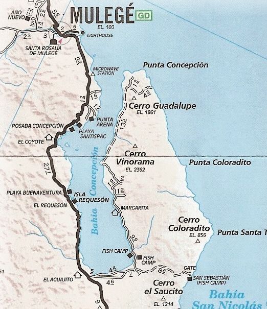
The 1993 Baja Almanac, map book, Map #37:
|
|
|
Pompano
Elite Nomad
Posts: 8194
Registered: 11-14-2004
Location: Bay of Conception and Up North
Member Is Offline
Mood: Optimistic
|
|
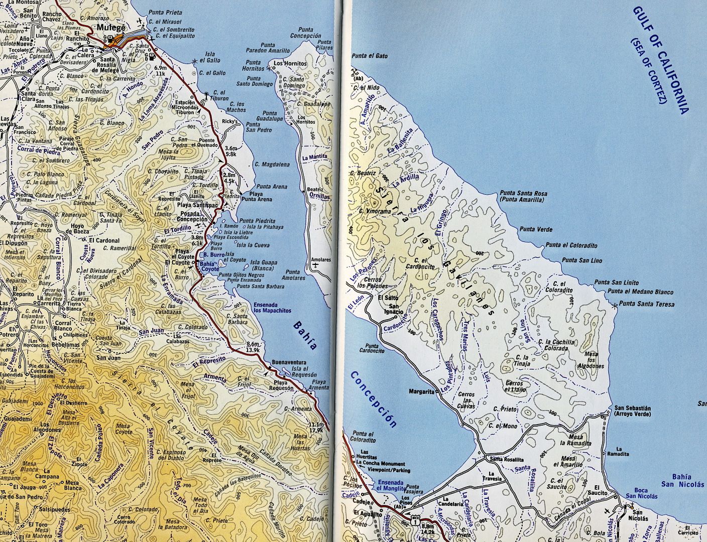
The peninsula has never been much of a mystery to people who live here. It's been very popular over the years and a few hundred people lived at the
mine back in the day. The two fish camps shown at the bottom of the photo are long gone. Others are scattered up the bayside of the peninsula...some
go dormant for years, then come back when it's time to rape some more marine-life. Some trails are not shown..like the one around the tip and back
to the mine.
I think I have a project in mind. A photo trip around the BOC peninsula? Might be of some use to today's new adventurers.
[Edited on 12-24-2013 by Pompano]

I do what the voices in my tackle box tell me.
|
|
|
David K
Honored Nomad
Posts: 65589
Registered: 8-30-2002
Location: San Diego County
Member Is Offline
Mood: Have Baja Fever
|
|
Yes indeed Roger... and since the manganese mine was active during WWII or there-abouts, I wonder why Erle hadn't been informed? There was no mention
of it in the 1956-1964 Lower California Guidebook, so maybe that was his only source for data on it?
|
|
|
Pompano
Elite Nomad
Posts: 8194
Registered: 11-14-2004
Location: Bay of Conception and Up North
Member Is Offline
Mood: Optimistic
|
|
Well, I'm kinda busy at the moment filleting steelhead (on a good day!), but I reckon I can dig through my morgue & put together a photo map for
TLBaja79 before he heads out there on his March trip.
Always fun to take another trip in Baja!
I do what the voices in my tackle box tell me.
|
|
|
Vince
Nomad
Posts: 448
Registered: 10-17-2006
Location: Coronado
Member Is Offline
|
|
This October I was exploring the east coast of Conception bay and totally enjoyed it. I was in my 16 foot Boston Whaler and spent most of the day
trolling and observing. It was very quiet, no people, no fish camps, only Frigate birds and Sierra fish. It seemed like it was back in the early
1960's when I first went over there. It was pristine and wonderful. I looked for the old ranch that we found in the early '60's, but it was long
gone. It was abandoned even back then. You should enjoy camping there.
|
|
|
Mula
Super Nomad
Posts: 1665
Registered: 8-16-2011
Location: San Nicolas y Lopez Mateos
Member Is Offline
|
|
We usually go to the Peninsula for 3 or 4 days every May. Take 4 wheelies, skiffs and go out in the Pickups. No fish camps, very quiet and serene
except for the trucks on the Mex 1 across the water at night.
|
|
|
Pompano
Elite Nomad
Posts: 8194
Registered: 11-14-2004
Location: Bay of Conception and Up North
Member Is Offline
Mood: Optimistic
|
|
Characters gone from the scene today. Anyone remember Corana Dave? He lived out near the point in a ramshackle palapa for a few years. Yvonne was
his companion. They had some times!
And of course, Baja Patty at her horse ranch was a real Baja lover and much loved by others. Her place had/has good water.
I do what the voices in my tackle box tell me.
|
|
|
KurtG
Super Nomad
Posts: 1211
Registered: 1-27-2004
Location: California Central Coast
Member Is Offline
Mood: Press On Regardless!!
|
|
| Quote: | Originally posted by Pompano
Characters gone from the scene today. Anyone remember Corana Dave? He lived out near the point in a ramshackle palapa for a few years. Yvonne was
his companion. They had some times!
And of course, Baja Patty at her horse ranch was a real Baja lover and much loved by others. Her place had/has good water. |
I do remember Corona Dave and hearing him on the VHF inquiring what day it was. Seemed he would lose a few from time to time.
|
|
|
Bob and Susan
Elite Nomad
Posts: 8813
Registered: 8-20-2003
Location: Mulege BCS on the BAY
Member Is Offline
Mood: Full Time Residents
|
|
the part across the bay is really green...
our little boat has been going over to
Playa Domingo (Sunday Beach)
over here...we call it "jingle beach"
there is a fish camp near but not much action
we see cars on the "tracks" once in a while
but hardly ever
i'd take a boat over if it was me...take a few minutes to cross
"sharky" made a run to the tip a few years ago with his dog
and photographed it
some "bikers" rented a panga a few years ago and floated over for the "ride" to loreto...wow...they were loud
there is nothing over there so have a plan for emergencys

|
|
|
monoloco
Elite Nomad
Posts: 6667
Registered: 7-13-2009
Location: Pescadero BCS
Member Is Offline
|
|
In Nov-Dec 1993 I spent 3 weeks camped out with friends at Punta Amolares. Took over the fish camp palapas which were abandoned at the time. We had
great windsurfing, kayak fishing, and awesome hiking and climbing in the mountains of the peninsula. I remember there were some gringos who had a
pretty nice rancho right on the water near to where Baja Patty had lived. I haven't been back since and have often wondered what happened to their
place.
"The future ain't what it used to be"
|
|
|
Bob and Susan
Elite Nomad
Posts: 8813
Registered: 8-20-2003
Location: Mulege BCS on the BAY
Member Is Offline
Mood: Full Time Residents
|
|
we think there is water there...
no one wants to hike up the hill

|
|
|
Casey67
Junior Nomad
Posts: 75
Registered: 4-4-2009
Location: Bahia Concepcion
Member Is Offline
Mood: Baja Hot
|
|
The prominent point halfway down is a decent place to camp. It's essentially straight across from Burro/Coyote beaches. You might be able to work out
an arrangement with Juan Carlos to bring you extra water/supplies on his pontoon boat since he's over near there often for fishing and clamming.
You'll find him at his JC's Restaurante el Burro on the highway across from the entrance to Burro beach.
Near the tip on the inside has a bit of a beach looking area I've yet to explore or camp. It's a possibility but not sure about the road there.
The road gets messed up by big rains but within 6 months it's usually fixed up to passable, at least in a 4x4. Rain usually only comes in the fall, so
by March you should be good. The people that come and go from the fish camps and ranches over there make sure of having a way in and out. I don't know
if they go all the way to the tip but usually the road to half way is driveable in a regular pickup once they've cleaned it up.
I don't know if this has changed, but historically it is NOT recommended to leave a vehicle parked alone anywhere near the south entrance section of
the peninsula road because of thievery.
Good luck on your trip. I'm at JC's or Bertha's store (km107 Coyote area) sometimes, so maybe we'll bump into each other.
A rose by any other name is still just rice
|
|
|
David K
Honored Nomad
Posts: 65589
Registered: 8-30-2002
Location: San Diego County
Member Is Offline
Mood: Have Baja Fever
|
|
Photos (Pompano's and other's) of the Manganese mine ('Gavilan') and other spots on the Concepcion peninsula have been posted on Nomad:
http://forums.bajanomad.com/viewthread.php?tid=55285
http://forums.bajanomad.com/viewthread.php?tid=51392
Here is something I posted in 2011:
| Quote: | Originally posted by rockman
There are several references to the Gavilan mine which produced manganese (not magnesium) for the US war effort during WWII. At that time, more than
6,000 people worked at the mine. It was operated by a Mexican subsidiary of the Homestake Mining Co. Lessened post-war demand diminished the
output, and the mine closed when a hurricane devistated much of the infrastucture in 1946. Although many of the foundations and concrete floors still
survive, all of the equipment was salvaged and moved to other operations. The ore consisted of veins of pyrolusite, traces of which can still be
picked up. There are great campsites, but the drive from the west side of the peninsula to the east can be quite challenging. High clearance is
mandatory.
Best References:
Baja Explorer magazine (Later called Baja Life), Nov-Dec, 1991. Article by Bob Vinton.
Manganese on Punta Concepcion, by James Noble, Calif Inst of Tech, in Economic Geology, v45#8, Dec, 1950. |
Here is the magazine cover, followed by the 4 pages of the article by Baja Bob (Bicycle Bob) Vinton!
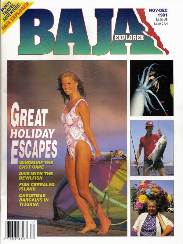

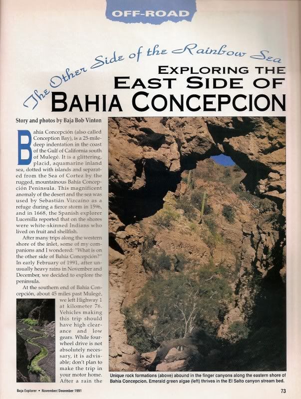

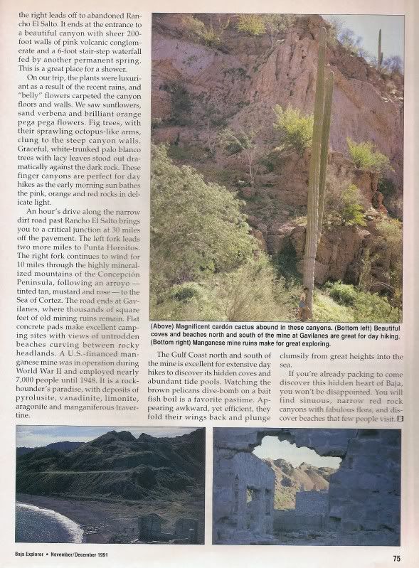
The Baja Explorer Magazine was one of the great creations of Landon Crumpton, who also published the Baja Atlas and Baja Almanac Map Books.
|
|
|
TLBaja79
Nomad
Posts: 270
Registered: 10-17-2013
Member Is Offline
|
|
Nomads are the best.
Thank you all for the input. Talk about a great source of information on Everything Baja!
I'm familiar with Baja Camping in the middle of nowhere. Would you guys say there is more of a concern now for safety (personal? or always theft)
than in the past. Removed from Baja camping for 10 years, I know a lot has changed. Or taking the usual precautions the norm for then and now?
I could see fishermen taking advantage of a truck/camp with nobody tending to it out on the Conception Penninsula, its almost like I'm getting the
feel that its flat out dangerous in that area? Or is petty theft the latest and greatest for them?
Probably opening up a can of worms but I'm always interested.
|
|
|
Bob and Susan
Elite Nomad
Posts: 8813
Registered: 8-20-2003
Location: Mulege BCS on the BAY
Member Is Offline
Mood: Full Time Residents
|
|
davidk is talking about leaving your stuff at the south end of the bay and leaving...
this is probably NOT a good idea...its like leaving it on the highway...
not a good idea
the Conception Penninsula is empty...no one there...EMPTY...
there is no support unless you set it up in advance
if no one is there its safe
very few go there unless they take a boat
|
|
|
chuckie
Elite Nomad
Posts: 6082
Registered: 2-20-2012
Location: Kansas Prairies
Member Is Offline
Mood: Weary
|
|
We do the jingle beach and mine areas a couple of times a year, by boat. Have been all the way to the mine in a 4wd truck a couple of times but not
recently. Fascinating area..we were talking about doing it again, just the other day....
|
|
|
Pescador
Ultra Nomad
Posts: 3587
Registered: 10-17-2002
Location: Baja California Sur
Member Is Offline
|
|
When we run the peninsula, we do it on quads and it is a long one day trip. We leave our vehicle or vehicles at Punta Las Tasajeras where there are
some houses and fishermen who catch and process sting rays. We pay them a few bucks and it is much safer. IF you want to lose all your stuff, park
in the old campground area and everything will be gone within a half-hour. They will break windows, pry open trunks, everything and they do stuff
very quickly.
The peninsula road is like being in a different part of Baja as the flora and fauna is different from the other side of the bay. It is a great place
to explore.
Last time there were three people camping at one of the old fish camps and they were from University at Mexico City and doing a study on the Catarina
Scallops. They had a good crop growing and it was fun to see how they swim by opening and closing their shells. The military has been very active in
that area, especially where the road takes off to San Sebastian.
|
|
|
| Pages:
1
2 |