| Pages:
1
..
8
9
10
11
12
..
23 |
Debra
Super Nomad

Posts: 2101
Registered: 10-31-2002
Location: Port Orchard Wa./Bahia de Los Angeles BC
Member Is Offline
|
|
elbeau, I didn't read all 8 pages here, but, I can assure you that DK is sincere in his love and trustworthyness of all things Baja, having traveled
with him many times over the last 10yrs. in his search for the "Lost Mission" I have first had experience being totted all over the desert, that I
think I deserve to be in on this hunt............howsabout it David? I'll be heading down on the first and in Baja for a couple of months. Can I
come?
Mean people suck!
|
|
|
elbeau
Nomad
Posts: 256
Registered: 3-2-2011
Location: Austin, TX
Member Is Offline
|
|
| Quote: | Originally posted by Debra
elbeau, I didn't read all 8 pages here, but, I can assure you that DK is sincere in his love and trustworthyness of all things Baja, having traveled
with him many times over the last 10yrs. in his search for the "Lost Mission" I have first had experience being totted all over the desert, that I
think I deserve to be in on this hunt............howsabout it David? I'll be heading down on the first and in Baja for a couple of months. Can I
come? |
At this point, it's up for grabs for anybody to go. TW made a visit to the arroyo a couple weeks ago, but not all the way to the so-called mission
site. It sounds like there's interest in another trip towards the end of April. If you can go sooner, go for it! I'd love to hear what you find.
|
|
|
Debra
Super Nomad
Posts: 2101
Registered: 10-31-2002
Location: Port Orchard Wa./Bahia de Los Angeles BC
Member Is Offline
|
|
Thank you, but, being the 56yr. old Grand-MA with a broken back attained in Punta Cabras on an Baja trip with friends in Aug. 2001, my ideas of solo
into the desert are long gone....... however, be assured anyone that may want to take up this adventure, my rig is totally desert proof, have many
parts that you might need also, and I cook! And I have room for a couple of passengers.
As I said, I'll be down somewhere around the 1'st, please keep me in mind if a outing is planned, Thanks
Mean people suck!
|
|
|
David K
Honored Nomad
Posts: 65549
Registered: 8-30-2002
Location: San Diego County
Member Is Offline
Mood: Have Baja Fever
|
|
Hi Debra (aka 'travelpearl'),
I was right on this and have talked to elbeau on the phone, as well.
Having searched for (and finally found*) one of the 'lost Baja missions... I am very supportive of desert exploration.
I just wanted elbeau to not be let down if the blured satellite images were not the arches, fountains and stairways he sees in them. Do go back and
look throught the previous pages... You will see that TW went there... maybe he didn't climb up the cliffs to stand on the spot... but he was in the
arroyo at the base of the target.
There is much yet to be discovered in Baja... or re-discooved!
(* with the help of a Nomad also using Google Earth who spotted the wall I was seeking.)
|
|
|
TMW
Select Nomad
Posts: 10659
Registered: 9-1-2003
Location: Bakersfield, CA
Member Is Offline
|
|
elbeau I would like you to mark out on Googler Earth exactly what you want us to photograph. I mean like the exact corrdinate spots. That way we can
use the GPS and take pictures of that exact location. My assumption is that we would go to the location where pictures 16-20 were taken and climb up
above. If time permits we can move further down the wash area maybe from the area above and see whats there. From the west side high above maybe even
see the corral area. We need to allow about 4 hours to go in and come out, 2 each way.
|
|
|
wilderone
Ultra Nomad
Posts: 3906
Registered: 2-9-2004
Member Is Offline
|
|
"...a broken back attained in Punta Cabras on an Baja trip with friends in Aug. 2001 ..."
That sounds like an interesting story. Details? (maybe another thread so as not to hijack)
|
|
|
David K
Honored Nomad
Posts: 65549
Registered: 8-30-2002
Location: San Diego County
Member Is Offline
Mood: Have Baja Fever
|
|
| Quote: | Originally posted by wilderone
"...a broken back attained in Punta Cabras on an Baja trip with friends in Aug. 2001 ..."
That sounds like an interesting story. Details? (maybe another thread so as not to hijack) |
Overly discussed on Amigos de Baja after it happened... It was an accident on a quad and friends helped each other. Lot's of us were there including
4baja, Dern, Fishin' Rich, Desert Bull, my son and daughter and her friend. Photos and some details of what happened on that trip: http://vivabaja.com/cabras
[Edited on 3-23-2011 by David K]
|
|
|
edm1
Senior Nomad
Posts: 568
Registered: 8-23-2006
Location: Oak Hills, Ca
Member Is Offline
|
|
Very interesting thread. I will be following this.
|
|
|
Bajatripper
Ultra Nomad
Posts: 3152
Registered: 3-20-2010
Member Is Offline
|
|
| Quote: | Originally posted by edm1
Very interesting thread. I will be following this. |
Hey, Art, long time, no posting (that I've seen, at least). Hope things are going well for you and your unstoppable rig. When you making it down this
way?
|
|
|
elbeau
Nomad
Posts: 256
Registered: 3-2-2011
Location: Austin, TX
Member Is Offline
|
|
| Quote: | Originally posted by TW
elbeau I would like you to mark out on Googler Earth exactly what you want us to photograph. I mean like the exact corrdinate spots. That way we can
use the GPS and take pictures of that exact location. My assumption is that we would go to the location where pictures 16-20 were taken and climb up
above. If time permits we can move further down the wash area maybe from the area above and see whats there. From the west side high above maybe even
see the corral area. We need to allow about 4 hours to go in and come out, 2 each way. |
TW, I've had a couple of busy days but I'll get this put together for you. sorry for the delay.
|
|
|
TMW
Select Nomad
Posts: 10659
Registered: 9-1-2003
Location: Bakersfield, CA
Member Is Offline
|
|
No problem. We're not going down until near the end of April. I have a new digital camera and I can now take thousands of pictures.
|
|
|
David K
Honored Nomad
Posts: 65549
Registered: 8-30-2002
Location: San Diego County
Member Is Offline
Mood: Have Baja Fever
|
|
Erle Stanley Gardner connection...
On Feb. 4, 2004 TW posted this:
Lost Mission Santa Ysabel
In Earl Stanley Gardner's book Hovering Over Baja, near the end he shows a picture and talks about the lost mission Santa Ysabel. The ruins in the
picture are somewhere between LA Bay and Catavina. Has anyone been there? Or dodes anyone know of the exact location shown in the picture? Has it been
linked to the missions?
==========================================================
I responded with this:
Uncle Erle was a great mystery novelist. The Santa Ysabel mission legend was well known in the 1950's and 60's when Erle did most of his Baja
exploring. Everyone was looking for something out of place, man made, etc. That adobe building in Hovering Over Baja was in fact an old pre-automobile
age rancho, not a Spanish ruin, I was told.
So, where is it? The book gives a few clues from the DC-3. But, where is the DC-3, you ask?
The DC-3 plane wreck that the chapter starts out talking about is on Cerro la Gobernadora (just northeast of El Crucero). GPS at the wreck is:
29º17.33'/ 114º06.57'
Thanks to Amigo-Nomad BillB, who climbed the peak and to the wreck and sent me the GPS and photos...
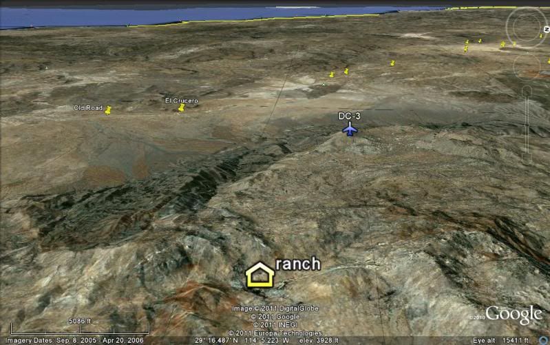
Erle writes he spotted a trail near the wreck and they followed it for several miles until the adobe was discovered. That region is the headwaters of
Arroyo Salsipuedes and La Asamblea. The new Rancho San Luis (29º16.72'/ 114º02.80') is back in there, behind a locked gate on a road that leaves Hwy.
1 where the old L.A. Bay road junction is, about 8 miles north of the new L.A. Bay hwy. junction.
Just to see the old grave tombs Erle mentions is worth an investigation! They sound like the tombs at Rancho Santa Ana, southwest of San Borja.
Bajataco has a great photo of those in his web site.
Choral Pepper searched for Santa Isabel near Puertecitos where the 1757 Jesuit map lists a waterhole (aguaje) of Santa Isabel. The lost Santa Clara
mission, near Punta Abreojos (listed as San Juan Bautista in 1757) is a better candidate for a lost mission. The ruins discovered in 1966, I have been
trying to re-find, is listed as Santa Maria Magdalena on that map, south of L.A. Bay.
======================================================
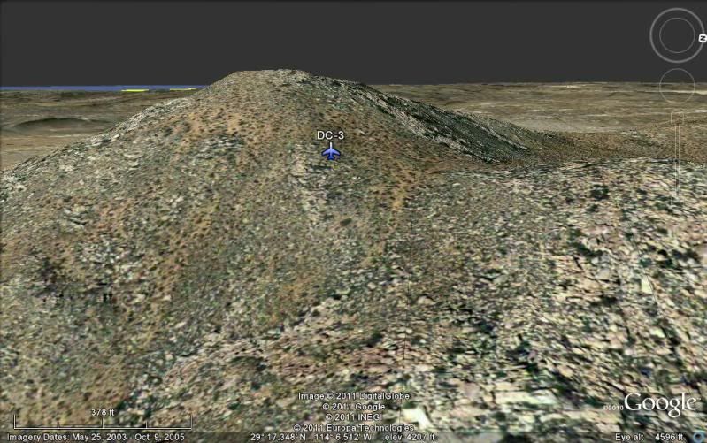
Here is Google Earth look at the DC-3 site (plane symbol):
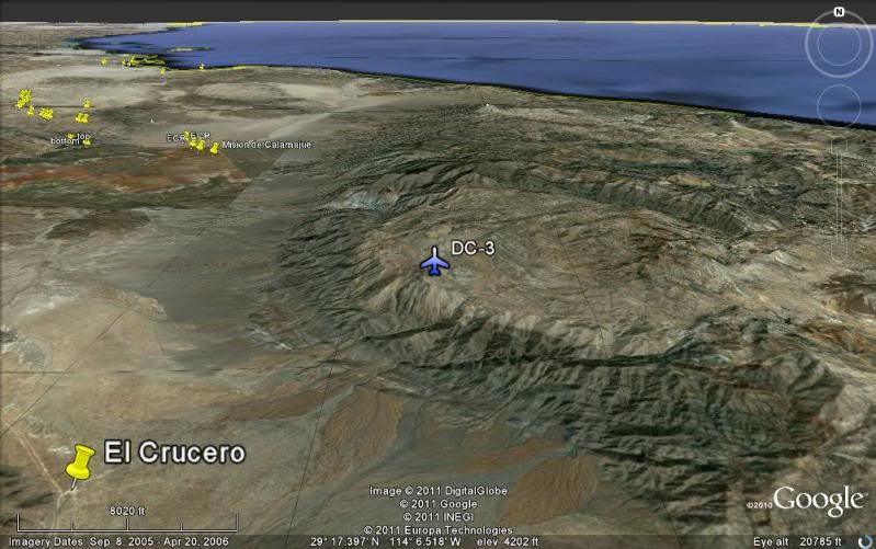
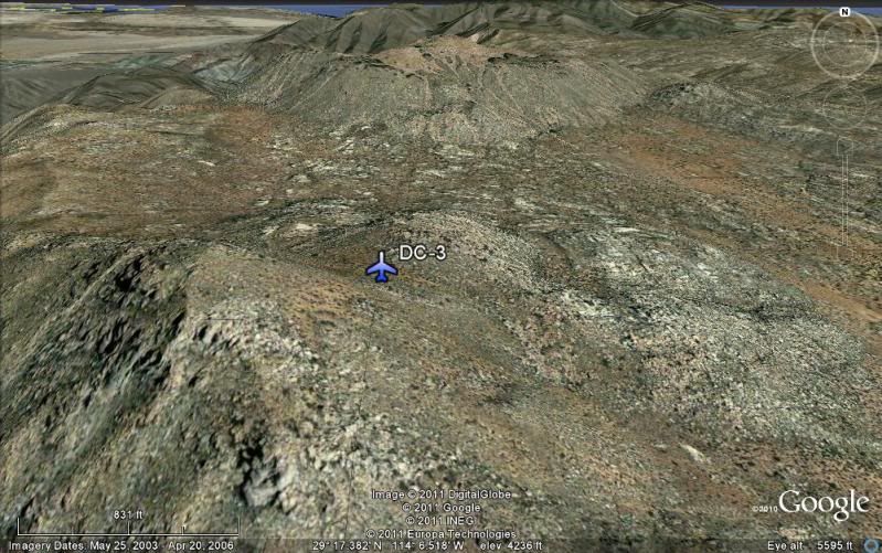
View West:
|
|
|
BAJACAT
Ultra Nomad
Posts: 2902
Registered: 11-21-2005
Location: NATIONAL CITY, CA
Member Is Offline
|
|
| Quote: | Originally posted by elbeau
| Quote: | Originally posted by BAJACAT
...I have been to El Volcan site, that to me is a very spooky place I drove all the way to the bend down stream, like a said very spooky
place...[Edited on 3-20-2011 by BAJACAT] |
I'm wondering what you mean by "spooky". I haven't heard it described that way before and it sounds like a good story. Please tell 
|
On my firts trip to the onyx school site,we went to the Volcano site, as you start to go down to the canyon
it feels and looks like this is a place that you are not supposse to be in. In the arroyo past the road to la Olvidada mine we drove down stream as
far as we could, we wonder around and it felt like if somebody was watching you no sound no signs of animal activity it was earie felling, but maybe
it was only me.A long time ago somebody mention that they camp on a death zone in Baja...also no animal activity or noise of any kind.
HERE IS THE LINK FOR THAT STORY http://forums.bajanomad.com/viewthread.php?tid=23493#pid2137...
[Edited on 3-26-2011 by BAJACAT]
BAJA IS WHAT YOU WANTED TO BE, FUN,DANGEROUS,INCREDIBLE, REMOTE, EXOTIC..JUST GO AND HAVE FUN.....
|
|
|
TMW
Select Nomad
Posts: 10659
Registered: 9-1-2003
Location: Bakersfield, CA
Member Is Offline
|
|
We camped just south of Miraflores on a side road coming from Mission Santa Gertrudis and it was the same way. No wind, no animals, no bugs, no birds,
no noise of any kind the whole time we camped. We packed up and when we got back to the main road everything was normal, wind, bugs, birds, animals
etc. This was about 2002 or 03. I know the spot and have wanted to go back but never did.
|
|
|
BAJACAT
Ultra Nomad
Posts: 2902
Registered: 11-21-2005
Location: NATIONAL CITY, CA
Member Is Offline
|
|
TW. it was you the one that told the story about the Death ZOne!
things are looking good on my part to do the SMM ride and later on to the Volcano site....
BAJA IS WHAT YOU WANTED TO BE, FUN,DANGEROUS,INCREDIBLE, REMOTE, EXOTIC..JUST GO AND HAVE FUN.....
|
|
|
elbeau
Nomad
Posts: 256
Registered: 3-2-2011
Location: Austin, TX
Member Is Offline
|
|
| Quote: | Originally posted by TW
No problem. We're not going down until near the end of April. I have a new digital camera and I can now take thousands of pictures.
|
Here you go:
Recommended Photos KML File
I drew a possible path for you to take, but obviously it matters much more that the photos get taken then how you get there. I'm sure once you're on
the ground you'll find that I inadvertently drew the line right over a 100' cliff or something. Please don't follow my lines off of cliffs.
The photo angles that are blue are ones I think are important to understand the site. The angles in yellow are really just stuff I'm curious about
and can't make heads or tails of.
Also, I put some other placemarks in the file hoping that you or a future traveler might be able to shed some light on some other features in the
arroyo area.
This should keep that new camera of yours busy 
I'd love it if you set the camera resolution all the way up to your highest setting that you mentioned in the thread when you bought the camera. You
can never have enough pixels 
|
|
|
wilderone
Ultra Nomad
Posts: 3906
Registered: 2-9-2004
Member Is Offline
|
|
Can you "save to" something other than a KML file? Can't open.
|
|
|
David K
Honored Nomad
Posts: 65549
Registered: 8-30-2002
Location: San Diego County
Member Is Offline
Mood: Have Baja Fever
|
|
| Quote: | Originally posted by wilderone
Can you "save to" something other than a KML file? Can't open. |
I can't open either... never have been able to... I get a pop up that asks what program to use to open it, and don't know what works... Google isn't
one, I have looked...???
|
|
|
bufeo
Senior Nomad
Posts: 793
Registered: 11-16-2003
Location: Santa Fe New Mexico
Member Is Offline
|
|
I don't have a suggestion for any difficulties in opening elbeau's link. It opens for me in Google Earth®. The "path" is marked with
pushpins.
Allen R
On edit: Unless I'm missing something here????
[Edited on 3-29-2011 by bufeo]
|
|
|
elbeau
Nomad
Posts: 256
Registered: 3-2-2011
Location: Austin, TX
Member Is Offline
|
|
| Quote: | Originally posted by David K
| Quote: | Originally posted by wilderone
Can you "save to" something other than a KML file? Can't open. |
I can't open either... never have been able to... I get a pop up that asks what program to use to open it, and don't know what works... Google isn't
one, I have looked...??? |
Weird. I really don't know why it does work on some computers but not on others. I just tried opening it from a completely different computer and
operating system than the one I made it on and it recognized it just fine and it opened.
Try right-clicking the KML file link and then choose to save the file to your file system (In windows I think the menu option says "Save Target" or
something like that). Then, open up Google Earth and using Google Earth's "File" menu, choose "Open" and select the file you saved. If it works,
then the problem is simply that you don't have the .kml extension associated with Google Earth. If it doesn't work, then the problem is that Google
Earth really can't read the file. This might happen if your Google Earth installation is not the current version, or it might happen if there's
something wrong with my file itself.
Please let me know. I'd like this to work for people.
Thx.
(edited for grammar)
[Edited on 3-29-2011 by elbeau]
|
|
|
| Pages:
1
..
8
9
10
11
12
..
23 |