| Pages:
1
..
9
10
11
12
13
..
23 |
elbeau
Nomad
 
Posts: 256
Registered: 3-2-2011
Location: Austin, TX
Member Is Offline
|
|
| Quote: | Originally posted by bufeo
The "path" is marked with pushpins. |
Just to be clear, there are a few push pins, but those aren't the path. They're just some questions I have about the area and some of them aren't
even really along the way you guys are planning on going on this trip. In fact, some of them may be able to be answered by you guys already.
The "path" is marked as a white line with directional arrows. The path is about 4.65 miles long if I remember right. Along the path you will see
"camera" icons which each have a blue or yellow bubble coming from the camera lense. These represent photos that I hope can be taken. The camera is
placed at the spot were I would like you to stand and the blue or yellow bubble shows both the direction and scope of the target I am hoping you can
photograph from that spot. (of course, if it turns out that my exact camera position is behind a huge rock, please don't take a picture of the rock
 Once you're there I'm sure you will be able to find the most reasonable place
to take those photos from. The blue bubbles are photos that I think are critical to putting this matter to rest. The yellow bubbles are kind of
"nice-to-have" photos of features I would like to understand, but which are explaining geological features rather than archaeological features or are
things I just can't make much sense of from the satellite images. Once you're there I'm sure you will be able to find the most reasonable place
to take those photos from. The blue bubbles are photos that I think are critical to putting this matter to rest. The yellow bubbles are kind of
"nice-to-have" photos of features I would like to understand, but which are explaining geological features rather than archaeological features or are
things I just can't make much sense of from the satellite images.
Thanks.
|
|
|
David K
Honored Nomad
        
Posts: 65425
Registered: 8-30-2002
Location: San Diego County
Member Is Offline
Mood: Have Baja Fever
|
|
| Quote: | Originally posted by elbeau
| Quote: | Originally posted by David K
| Quote: | Originally posted by wilderone
Can you "save to" something other than a KML file? Can't open. |
I can't open either... never have been able to... I get a pop up that asks what program to use to open it, and don't know what works... Google isn't
one, I have looked...??? |
Weird. I really don't know why it does work on some computers but not on others. I just tried opening it from a completely different computer and
operating system than the one I made it on and it recognized it just fine and it opened.
Try right-clicking the KML file link and then choose to save the file to your file system (In windows I think the menu option says "Save Target" or
something like that). Then, open up Google Earth and using Google Earth's "File" menu, choose "Open" and select the file you saved. If it works,
then the problem is simply that you don't have the .kml extension associated with Google Earth. If it doesn't work, then the problem is that Google
Earth really can't read the file. This might happen if your Google Earth installation is not the current version, or it might happen if there's
something wrong with my file itself.
Please let me know. I'd like this to work for people.
Thx.
(edited for grammar)
[Edited on 3-29-2011 by elbeau] |
That worked! Thanks...
|
|
|
David K
Honored Nomad
        
Posts: 65425
Registered: 8-30-2002
Location: San Diego County
Member Is Offline
Mood: Have Baja Fever
|
|
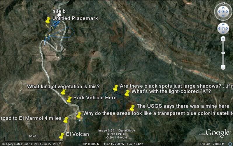
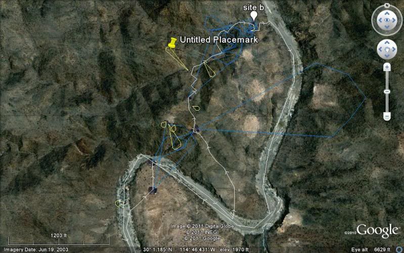
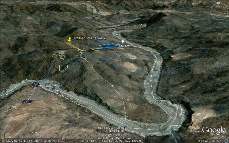
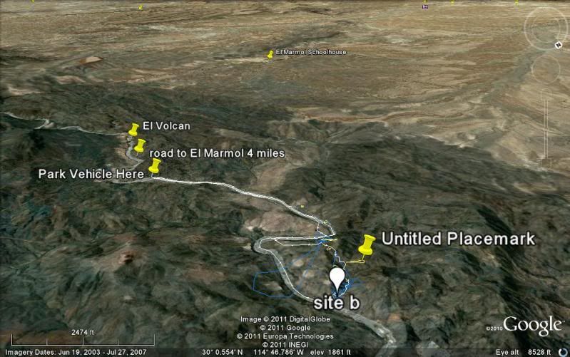
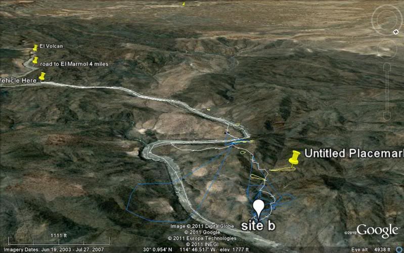
Okay, here are 5 images with elbeau's track and markings... The white balloon site b marker is mine at the spot where elbeau sees the lost mission.
The first three images are with north at the top, and the last two are southward, towards the El Marmol schoolhouse (yellow pin in distance):
[Edited on 3-29-2011 by David K]
|
|
|
David K
Honored Nomad
        
Posts: 65425
Registered: 8-30-2002
Location: San Diego County
Member Is Offline
Mood: Have Baja Fever
|
|
elbeau, what is the yellow pin (untitled placemark) above the lost mission indicating?
|
|
|
elbeau
Nomad
 
Posts: 256
Registered: 3-2-2011
Location: Austin, TX
Member Is Offline
|
|
| Quote: | Originally posted by David K
elbeau, what is the yellow pin (untitled placemark) above the lost mission indicating? |
Oops. That pin is labeling the trail that Tom and I believe goes through the site.
|
|
|
TMW
Select Nomad
      
Posts: 10659
Registered: 9-1-2003
Location: Bakersfield, CA
Member Is Offline
|
|
OK, I'll set my camera on high Res. I think Bajacat has a digital camera too so we should get lots of pictures. I'll bring a happy snappy for backup
too. It took us 2 hours to get to the corral area with a few stops going in. So we'll need to start early so as to get a full day in the area. By the
way we could only get around the first bend to the first large vegitation area due to rocks in the wash. This is closest to where the road from El
Marmol mkeets the wash.
|
|
|
elbeau
Nomad
 
Posts: 256
Registered: 3-2-2011
Location: Austin, TX
Member Is Offline
|
|
I might have found a way to pull together enough money for my wife and I to join you on the trip. That doesn't mean I've convinced her to go  and I'd have to arrange for a relative to fly to town to watch my kids while we're
gone, so it's not a done deal, but I'd like to try to come if you don't mind some more company. and I'd have to arrange for a relative to fly to town to watch my kids while we're
gone, so it's not a done deal, but I'd like to try to come if you don't mind some more company.
I'm not sure who all is going on the trip yet, and I don't know what dates everybody is going. If someone's going to be driving down from San Diego
the day before and coming back the day after and if you have some room and want to split gas money, please let me know. I'm thinking of taking an
early morning flight into SD, renting a vehicle, then driving to the site one day, hiking in and out the next day, the driving back to SD the
following day and flying home. It'd be a quick trip, but I sure would like to make it work.
Also, I'm having a hard time finding glowing reports on how safe it is for a consummate gringo who can barely pronounce the menu at Taco Bell to
travel outside tourist destinations in Mexico, including Baja. I'm sure a lot of you will have a lot of different opinions about this, but seriously,
I've got four kids and I don't want to be stupid and mess up their lives just so I could go for a day hike in Baja. Honestly, is it risky?
TW, how much of a difference would it make to rent ATV's for that terrain?
|
|
|
TMW
Select Nomad
      
Posts: 10659
Registered: 9-1-2003
Location: Bakersfield, CA
Member Is Offline
|
|
I think an ATV would make it most of the way. Close to the site there are rocks that may be a problem.
As to safety many things are said both ways with those that love Baja it's great and I know people that will never come down. It's really a matter of
to each their own. The language is really not a problem since many Mexicans that deal with Americans speak enough english that you would feel OK. I'm
talking about hotels, resturants and gas stations mostly. It is better to have a simple dictionary that allows you to translate some words so you can
better communicate. I am not fluent in spanish but I know enough words that I get by. My real problem is that when they talk it sounds like a machine
gun and I can't make out anything. I travel thru out Baja by my self often and I get along fine. I do stay away from the border as much as possible
and cross it during the day. I usually don't travel at night, at least not long after dark.
My plans right now are to come down with my brother on April 25th to meet Ken Cooke on the 26th and help him thru the mine road run that a little
further down Baja. Ken was then going to LA Bay for the 27th and return to Catavina and do the mission Santa Maria run on the 28th. Bajacat and I were
going there too. This is not set in stone yet and if Ken doesn't do the mine run I'll come down later for the mission run.
We should have the dates pretty much fixed in the next week or two.
|
|
|
elbeau
Nomad
 
Posts: 256
Registered: 3-2-2011
Location: Austin, TX
Member Is Offline
|
|
That sounds good. Thanks for the info. I'll see if it looks reasonable to do from my end and let you know.
|
|
|
David K
Honored Nomad
        
Posts: 65425
Registered: 8-30-2002
Location: San Diego County
Member Is Offline
Mood: Have Baja Fever
|
|
If my business ever gets going before then, I will come on down... Too much fun not to!
El Marmol is about 2 hours drive from El Rosario... or 7 hours drive from the border. Arroyo el Volcan is 4.0 miles from El Marmol (take right fork,
2.0 miles from El Marmol)... That left fork at mile 2.0 goes around the top of the arroyo drainage... the peninsular divide... above the lost mission
site to a mine dig... Another left branch off of it goes to a ditched drug runner's runway (actually there are two you can see on Google Earth). Drove
out to it in 2006 looking for a route to the gulf (this is near the Bill Nichols trail).
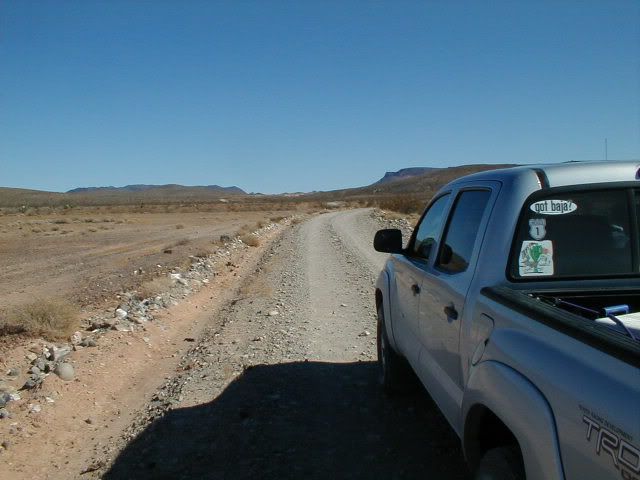
The 9 mile road to El Marmol from Hwy. 1 is fast and easy:
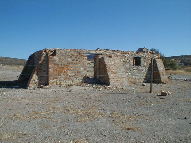
The onyx schoolhouse ruin is the only building remaining in this ghost town that closed up in 1958:
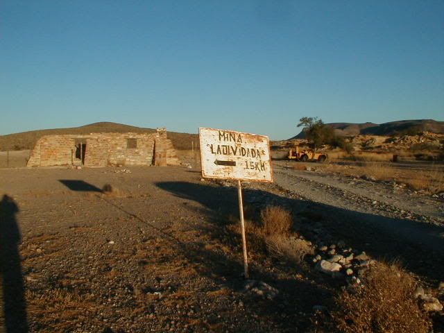
There may be a sign pointing the road that forks left, just before the schoolhouse:
This is the fork at Mile 2.0 from the schoolhouse, right to drop down, down, down to El Volcan and on to La Olvidada or left to dead ends at prospects
and ditched airplane runways:
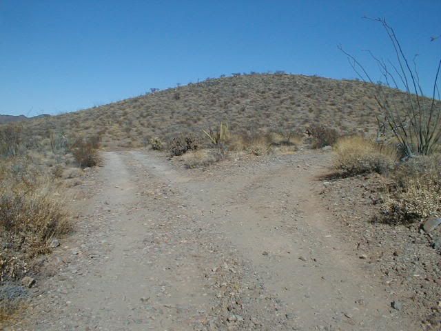
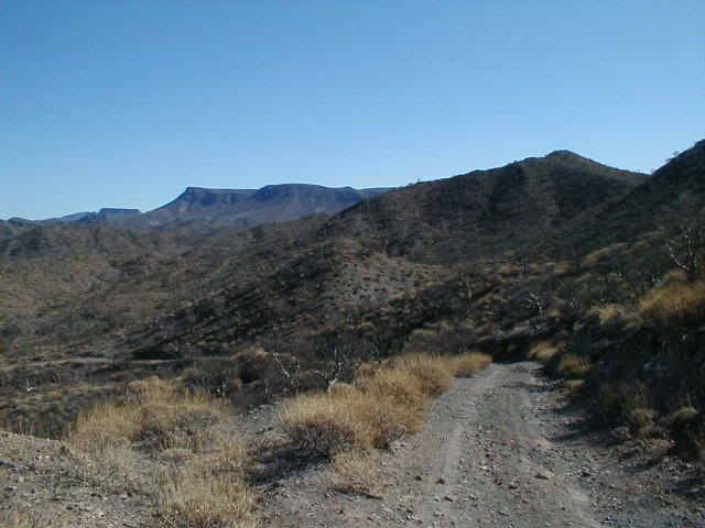
The long downgrade to El Volcan wash:
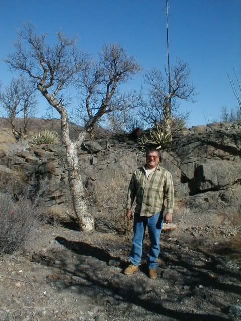
Lot's of Elephant trees grow here:
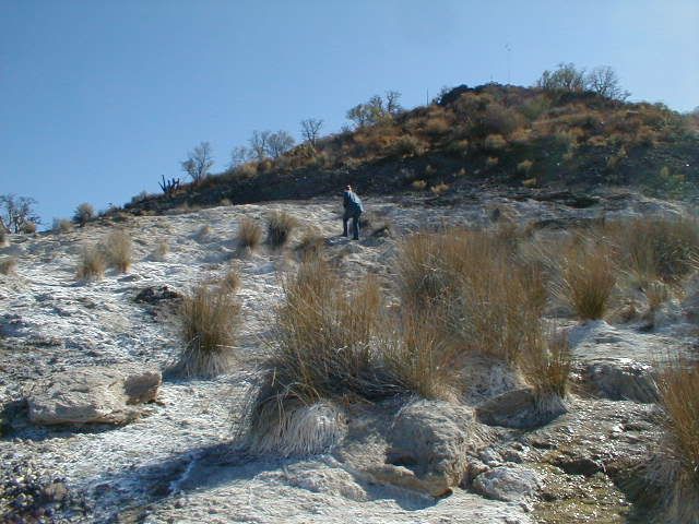
This is the white slope next to the road you come to if you cross the wash and head about 1/4 mile beyond:
To see El Volcan... turn right in the wash and go about 1/2 mile (you may be able to drive about half that in the wash)... the onyx dome (geyser) is
on the right side of the arroyo, against the cliff... Here's me standing on top:
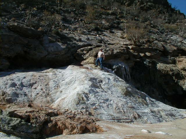
The Lost Santa Isabel Mission mystery site is to the LEFT in the arroyo where the El Marmol road crosses it.
[Edited on 3-29-2011 by David K]
|
|
|
TMW
Select Nomad
      
Posts: 10659
Registered: 9-1-2003
Location: Bakersfield, CA
Member Is Offline
|
|
When we were there last month someone had graded the road from El Marmol to the wash and maybe further but we didn't go past the wash. Maybe someone
is working a mine back there.
|
|
|
bryanmckenzie
Senior Nomad
  
Posts: 561
Registered: 9-23-2009
Location: 400 Km from Mexico Beach, Florida
Member Is Offline
Mood: Hot & humid --- not hot & dry.
|
|
Opening KML's & KMZ's
Don't open from the Internet/forum/thread.
Save the file to your hard drive.
The locate the file, right-click and "open with" Google Earth.
A KML is nothing more than a text file. If you change KML in the file name to TXT, you can actually open it with notepad. Of course, that does you no
good other than for editing.
I've had the same problem in the past posting/attaching.
| Quote: | Originally posted by bufeo
I don't have a suggestion for any difficulties in opening elbeau's link. It opens for me in Google Earth®. The "path" is marked with
pushpins.
Allen R
On edit: Unless I'm missing something here????
[Edited on 3-29-2011 by bufeo] |
|
|
|
bryanmckenzie
Senior Nomad
  
Posts: 561
Registered: 9-23-2009
Location: 400 Km from Mexico Beach, Florida
Member Is Offline
Mood: Hot & humid --- not hot & dry.
|
|
DOA. I'm not a believer
WOW! What a thread. I hate I'm 4 weeks late getting into it. But I patiently followed along anyway. What a way to kill an afternoon. I'm kind
of glad I didn't see this earlier because I'd probably be weighing in everyday with my skepticism. I suspect that if you posted this same theory over
on the GE BBS Forums you'd get the same feedback I'm about to provide.
I am a Google Earth afficiando and consider myself pretty good at interpretation (BajaLou would probably vouch for the quality &
integrity of some of my past work over at GE BBS) --- the KML file and GE imagery disclose NOTHING to me to indicate man-made features. No need to
ground-truth this at all. Or by wasting airplane fuel. TW et al, if you do go down, please read this post completely & count me in for the
trip (just for the adventure). Much of this long thread is completely missing some of the most obvious.
Now it's time to weigh in with my observations and the obvious:
I am a licensed civil/environmental engineer with a concentration in water resources and fluvial geomorphology (how water courses behave). Wind, also
being a fluid, can behave similar to water. I am NOT an archeologist. I just play one on TV.
"Geomorphology is the scientific study of landforms and the processes that shape them. Geomorphologists seek to
understand why landscapes look the way they do, to understand landform history and dynamics, and to predict future changes through a combination of
field observation, physical experiment, and numerical modeling." Ref.: GEOMORPHOLOGY
Scour and deposition with each rainfall/drainage event are natural occurences of water courses and floodplains; as are rock slides and land slides.
In Google Earth, I see absolutely NO EVIDENCE of man-made activity.
Ancient cultures built arched viaducts to carry water. They had a purpose. Arches are inherently stable by virtue of GRAVITY ... on a FLAT PLANE (they
work in COMPRESSION only). How does one build an arch on the side of a hill? A sloping surface? And for what
purpose? Resources, especially time and water were/are scarce. in a place like Baja. Everything that was man-made had a purpose.
What purpose would these arches-on-hillsides serve? Simply Google "stone arch" & select "images."
To the best of my knowledge, David K or Jack S help me out here, the mission structures and buildings were always built on flat
ground (see above lecture about gravity). None of your placemarks are on a large level area for structures or gardening. And they certainly
should NOT be in drainage courses. I'm pretty sure the good Friars were smart enough to know that.
Water courses, intermittent and perennial, always create "drops" or "dams" as was speculated. This is a natural erosion feature that is technically
called a "head cut" and migrates upstream until it hits bedrock ... think Niagra Falls, which until it was stabilized with concrete and steel migrated
many miles upstream to its present position. Again, no field trip or flyover needed for that.
The new post with the "two breasts" as MTgoat666 calls them is simply a hydraulic feature of the stream bed; most likely a bedrock
outcrop. Sandy beds move around and this arroyo clearly carries a braided stream at different times and locations. Water simply takes the path of
least resistance for a particular flow rate and slope and, voila, bed features are exposed and subsequently re-covered up. And the cycle repeats ...
think of a sandy beach over bedrock cobbles --- depending on tides, season, current and wave action --- the bedrock may or may not be exposed.
"There is much more water in the arroyo than previously thought" --- Since when is rainfall or streamflow
constant? It fluctuates 100% of the time. Besides, it's March right now; rainy season.
As to your remarks about discoloration, all images have some flaws: discoloration, streaks, glare, even color adjustments, depending on who took the
photo and for what purpose. The GE BBS Forums have extensive information on this. More importantly, since this is a mining region, we have different soils and materials. Each
leave their own marks and colors as the soils erode and underlying minerals beneath are exposed. It's kinda like why the mines are located here in the
first place.
No need to ground truth what are obviously gullies. I came to that conclusion long before coming to the point in this thread & the trip report
& seeing the ground photographs. All your "stairs" are in valleys/gullies, none on ridge lines or dry areas.
A walking path? A statue? Ornate tower? Decorated cave entrance (as opposed to undecorated)? You're kidding
me, right? At this resolution (I'm also a land surveyor with photogrammetry expertise), you'd be hard pressed to see much
detail. For what's worth, this photo is from Digital Globe (satellite --- not a 3000' level aerial surveying aircraft flyover) dated
18 June 2003. Click this image & turn on "more, DG Coverage" in Google Earth.
I cannot see evidence of a single structure or man-made object, with or without a shadow. Sorry, Elbeau, this KML (while well-made)
is simply the product of an over-active imagination or a ruse on the rest of us. Sorry to be blunt, but there was never anything here after the
initial post. In my book, this theory was DOA. I just calls 'em as I sees 'em. No hard feelings, I hope.
However, the previous trip would have been a fun one for me anyway. And if our intrepid road crew wants additional "staff" for the late
April trip, count me in. I'll go for the adventure because I love all of Baja's nooks & crannies.
[Edited on 2011-3-30 by bryanmckenzie]
[Edited on 2011-3-30 by bryanmckenzie]
|
|
|
bajalou
Ultra Nomad
    
Posts: 4459
Registered: 3-11-2004
Location: South of the broder
Member Is Offline
|
|
I think I'll try to get down for this search also. Maybe bring my quad to put around on.
I couldn't find anything there either, but exploring is it's own reward.
[Edited on 3-30-2011 by bajalou]
No Bad Days
\"Never argue with an idiot. People watching may not be able to tell the difference\"
\"The trouble with doing nothing is - how do I know when I\'m done?\"
Nomad Baja Interactive map
And in the San Felipe area - check out Valle Chico area |
|
|
mtgoat666
Platinum Nomad
       
Posts: 20494
Registered: 9-16-2006
Location: San Diego
Member Is Online
Mood: Hot n spicy
|
|
| Quote: | Originally posted by bryanmckenzie
The new post with the "two breasts" as MTgoat666 calls them is simply a hyraulic feature of the stream bed; most likely a bedrock
outcrop.
blah, blah, bla... |
well, my observation of breasts was just a joke inserted into the conversation between foolish treasure hunters (i see breasts everywhere).
didn't read your whole treatise, but you really should let the fools chase gold - keeps them off the internet and gives them some exercise!
|
|
|
bryanmckenzie
Senior Nomad
  
Posts: 561
Registered: 9-23-2009
Location: 400 Km from Mexico Beach, Florida
Member Is Offline
Mood: Hot & humid --- not hot & dry.
|
|
And I liked your joke. I, too, saw boobies.
Wow, you just called one of my writings a treatise. Thanks. I'm going to sleep well tonight. 
| Quote: | Originally posted by mtgoat666
| Quote: | Originally posted by bryanmckenzie
The new post with the "two breasts" as MTgoat666 calls them is simply a hyraulic feature of the stream bed; most likely a bedrock
outcrop.
blah, blah, bla... |
well, my observation of breasts was just a joke inserted into the conversation between foolish treasure hunters (i see breasts everywhere).
didn't read your whole treatise, but you really should let the fools chase gold - keeps them off the internet and gives them some exercise!
|
[Edited on 2011-3-30 by bryanmckenzie]
âTravel is fatal to prejudice, bigotry, and narrow-mindedness.â
-Mark Twain
Samuel Langhorne Clemens (November 30, 1835 â April 21, 1910)
|
|
|
elbeau
Nomad
 
Posts: 256
Registered: 3-2-2011
Location: Austin, TX
Member Is Offline
|
|
Hey Bryan, I know you took a couple of digs at me, but truthfully I'm glad to have you in the conversation even if you are a bit late 
You've covered a lot of ground, and most of what you've said is probably accurate, but let me make a few corrections:
First, you said:
| Quote: | | "All your "stairs" are in valleys/gullies, none on ridge lines or dry areas.A walking path? A statue? Ornate
tower? Decorated cave entrance (as opposed to undecorated)? You're kidding me, right? |
I know you read the whole post in one afternoon so I wouldn't expect you to remember every little phrase I wrote, so let me remind you of what I said
in the same remark where I released the KML file you're referencing:
| Quote: | | Some features are easier to see than others, and a couple of them (ie: the statue) is admittedly a stretch |
(pardon my poor grammer, but I didn't feel it proper to correct myself when quoting myself)
As far as the arches are concerned, you are correct that I can't explain why they would be where I say they appear to be. What I've said about the
arches is that I see them in the imagery and they certainly don't look anything like something 18th century missionaries would build, so if they do
exist, they may be quite old. On the other hand, DK has made a strong case that what we're looking at may simply be old mining implements. The point
is that we don't know if they even exist, only that they appear to exist in the images.
Like I said, I can't explain why they would exist going up a hill, I can't explain why they would exist if they were "only" decorative...which I've
never claimed, I would think that someone with your expertise would notice that when ancient structures slowly deteriorate, their arches are often the
last part of the old structure that is left standing. Your questions about the arches are proper questions to ask and certainly deserve an answer
that I can't give, in fact you may be completely correct in your logic and argument, but you're trying to rule out the possibility of their existence
using the same images that I'm using to argue for their existence and the only additional evidence you site is that we should "Simply Google "stone
arch" & select "images.""
so...I did:


Like I said, I like your questions about the arch, they are constructive to this conversation and have a logical basis, but I'll also bet that you'll
agree that ancient unknown civilizations can surprise us. Imagine yourself discovering Easter Island before anyone knew who built those magnificent
statues. Also imagine for a minute that this terrible, barren, water-starved peninsula you're looking at is right across the Gulf of California from
civilizations like the Aztecs and hasn't received NEARLY the archaeological attention as the mainland.
I probably do have an overactive imagination. I'll readily admit that, but I would hope that after reading this thread you could rule out the idea
that this is just a ruse. I might be crazy , but I'm not malicious. , but I'm not malicious.
C'mon, admit it, it's worthy of a day hike and a few good photos. I've ALWAYS said I could be wrong, and I even ADMITTED I WAS WRONG after Tom and
Bill's first trip report, before I got to review the photos. Like yourself, I'm trying to make it on this trip too, just for the adventure of it if
nothing else.
Welcome to the conversation. I'm glad to have someone with good expertise with GE chiming in. If these features really can be disproven from the
images we have or others you can produce, you will find me ready to accept that result, but we're not there yet.
I'd take up your argument about the water and the rainy season, but I'm just too tired. maybe tomorrow.
[Edited on 3-30-2011 by BajaNomad]
[Edited on 3-30-2011 by elbeau]
|
|
|
David K
Honored Nomad
        
Posts: 65425
Registered: 8-30-2002
Location: San Diego County
Member Is Offline
Mood: Have Baja Fever
|
|
Thanks for the great scientific explantation Bryan... I am happy that elbeau joined Nomad and shared his quest with us... Adventure is a good thing. I
had the pleasure of talking with elbeau over the phone after TW phoned me from San Felipe...
I also agree with you that the terrain at El Volcan is pretty twisted and can create weird shadows... that there no way is any structure at the
site... or that it would remain a secret with so many prospectors covering those hillsides the past 100+ years. El Marmol was a 'large' town (by Baja
standards up to 1958) and that whole region was well explored. Burro trips to see El Volcan were common too.
While it may not have been a typical mission, Santa Isabel (as the legend states) was more of a secret repository for the Jesuit treasures... so it
didn't need to resemble the typical mission. However, there never was any time to build anything more than a simple room or a cave, with any brief
time they had between learning of the king's orders and them being carried out.
In fact, the removal orders of the Jesuit priests was in a sealed secret envelope, not opened until that last moment before soldiers were sent to
fetch the padres.
Finally, there never was the time and energy to collect treasures or mine gold by the Jesuits or their Indians... they barely could feed themselves,
so all energy went into food production.
So, as with other 'lost missions' in Baja we have searched for, the treasure is just finding a site where men have built something... hundreds of
years ago... even if it is just a wall or the Camino Real trail... that is a thrill well worth the voyage and effort!
More on 'lost missions', here:
http://vivabaja.com/1757
http://vivabaja.com/109
|
|
|
elbeau
Nomad
 
Posts: 256
Registered: 3-2-2011
Location: Austin, TX
Member Is Offline
|
|
...yawn...stretch...grumble...sigh...ok, I'm awake now...let's cover a few more items from your post Bryan.
| Quote: | | I suspect that if you posted this same theory over on the GE BBS Forums you'd get the same feedback I'm about to provide. |
I agree. We should post this theory to the GE BBS and get opinions from people who have more experience than me interpreting GE imagery. As we get
feedback though, I would really like to make sure that the feedback makes it into this nomad thread because whether or not you agree with my
imagination, this thread is the single best resource you can find on the internet describing the Arroyo El Volcan AKA: Zamora Canyon AKA: Arroyo El
Tule. The area really is poorly documented online, and no matter what this investigation does or doesn't turn up, we should make sure the thread
documents it well.
Now, on to more of the substance of what you said:
| Quote: | | To the best of my knowledge, David K or Jack S help me out here, the mission structures and buildings were always built on flat
ground (see above lecture about gravity). None of your placemarks are on a large level area for structures or gardening. And they certainly
should NOT be in drainage courses. I'm pretty sure the good Friars were smart enough to know that. |
I have already addressed the substance of this statement a few times:
| Quote: | | I'm not saying this is a Jesuit mission, only that it is a possible source of the -legends- of a "Lost Mission of Santa Isabel". It doesn't have to
actually be a Jesuit mission in order to generate the stories. |
I also posed this question when I first opened the images and KML files up for everyone to see in this thread:
| Quote: | The site looks cool, but there are two elusive questions:
1. Why would the Jesuits (or whoever) built a "secret mission" so elegantly? |
The fact is, there are stories out there of lost "missions" and buried treasures. Personally, I REALLY don't think there's much of a chance of
finding any treasure whether it ever existed or not...but not only is it fun to look into these stories, but who know what we might find along the
way.
To address your statement about the mission being built on level areas away from drainage courses, well, that's a double-edged sword, because when
you're dealing with the legends of the "lost mission" you often run into versions of the story that describe some kind of landslide that both
destroyed (or partially destroyed) the so-called mission, and which covers the entrance to the cave or mine containing the Jesuit "Treasure".
...and...
Regardless of whether or not you think you see man-made structures in my photos, do you see the landslide?

Again, I know the landslide argument cuts both ways...it agrees with the legends, but choosing a location vulnerable to a landslide disagrees with the
foresight the "friars" should have had (unless, of course, they built it for the purpose of being burried...hehe...don't you love arguing against
legends that are not restricted to reason or facts?). But, on the other hand, I'm not exactly arguing that these so-called structures were built by
friars.
|
|
|
elbeau
Nomad
 
Posts: 256
Registered: 3-2-2011
Location: Austin, TX
Member Is Offline
|
|
And now, on to my rebuttal to your doubts about the water. You said:
| Quote: | | Since when is rainfall or streamflow constant? It fluctuates 100% of the time. Besides,
it's March right now; rainy season. |
Well...Since when is rainfall or streamflow constant? I never said it was. What I said is that we have reports of water pooled around rocks with
green vegetation growing around it, and we haven't found any studies about the water table in the area. So, let's look at what we DO know. We know
for a fact that right inside this same drainage, just a few short miles away, is El Volcan. El Volcan is a fresh-water geyser and from everything DK
and others have posted, we have every reason to believe that not only does this geyser spout large amounts of soda-water every month or so, but that
around the geyser are significantly-sized standing pools of water that do not dry up, whether or not it's rainy season. Perhaps there's evidence to
contradict this, but nobody has presented anything about El Volcan except that you always find standing pools of water, including one that "doesn't
seem to have a bottom".
We also know that both now and in the past large mammals, including big horn sheep, live around the arroyo. It's safe to say that those animals are
drinking --something-- and since the two closest water sources seem to be the spring near the coast 12 miles away and El Volcan. The stories I've
found of the big horn sheep and the antelope do not center around the geyser, so I'll ask you, where are they getting their drinking water?
The answer to this is that the evidence we have so far points to the idea of a high water table in the arroyo. Now, that's not an opened and shut
case, but it's hardly been refuted by anything you have presented.
Honestly, it really confuses me how both you and DK think that the water argument has been made to such a point that you can use it as evidence
against the possibility of an ancient culture in the arroyo area. Although DK readily points out that the Jesuits never mention a "Santa Isabel
Mission" in their writings, it wasn't until late in this post that he passingly mentioned that they did record a mention of a Santa Isabel source of
water.
My argument for this being a source of water might logically lead you to ask why nobody lives there now or in the recent past. That would be a good
question, but it would also be one you could as about the Santa Maria mission. In the end, anecdotal arguments about "why would someone do something
or not do something?" may lead you in a general direction of thought, but it is not evidence, and so far the evidence points towards the idea that
although the arroyo isn't exactly the Colorado River, it may not be as dry as previously assumed either.
edited because quoting Bryan's whole remark just took up too much room 
[Edited on 3-30-2011 by elbeau]
|
|
|
| Pages:
1
..
9
10
11
12
13
..
23 |
|

