| Pages:
1
..
10
11
12
13
14
..
23 |
elbeau
Nomad

Posts: 256
Registered: 3-2-2011
Location: Austin, TX
Member Is Offline
|
|
I have put a request for more professional eyes to look at this on the GE BBS at the following link:
Lost Civilization, Lost Mission, or Brain Damage?
|
|
|
TMW
Select Nomad
Posts: 10659
Registered: 9-1-2003
Location: Bakersfield, CA
Member Is Offline
|
|
Wouldn't water in El Volcan be like a series of ponds? Trapped in the sand by the rocks under the sand. We did see several places where there was
water near and around rocks. Several spots where there is green vegitation.
|
|
|
David K
Honored Nomad
Posts: 65549
Registered: 8-30-2002
Location: San Diego County
Member Is Offline
Mood: Have Baja Fever
|
|
I thought I was clear about Aguaje Santa Isabel from the start? See the web page I made about 8 years ago: http://vivabaja.com/1757
It was Choral Pepper who believed that being the only 'Santa Isabel' mentioned on a Jesuit map, surely the lost mission would be near there, so it
could be found when the time came that the Jesuits were allowed to return to California.
Since someone in the 1800's made up the legend, perhaps they used that name having seen the old map... I don't know, but I do know that there was
never any money allocated for any mission of Santa Isabel, never any mention of it on a list (as there was for San Juan Bautista/Santa Clara and Santa
Maria Magdalena).
|
|
|
elbeau
Nomad
Posts: 256
Registered: 3-2-2011
Location: Austin, TX
Member Is Offline
|
|
| Quote: | Originally posted by David K
I thought I was clear about Aguaje Santa Isabel from the start? See the web page I made about 8 years ago: http://vivabaja.com/1757
It was Choral Pepper who believed that being the only 'Santa Isabel' mentioned on a Jesuit map, surely the lost mission would be near there, so it
could be found when the time came that the Jesuits were allowed to return to California.
Since someone in the 1800's made up the legend, perhaps they used that name having seen the old map... I don't know, but I do know that there was
never any money allocated for any mission of Santa Isabel, never any mention of it on a list (as there was for San Juan Bautista/Santa Clara and Santa
Maria Magdalena). |
Perhaps I misspoke. I have a hard time remembering everything that has or hasn't been said too. If so, I apologize, and thank you for the history.
edited for spelling
[Edited on 3-30-2011 by elbeau]
|
|
|
David K
Honored Nomad
Posts: 65549
Registered: 8-30-2002
Location: San Diego County
Member Is Offline
Mood: Have Baja Fever
|
|
Repost from 10-31-04
Another chapter form Choral Pepper's last (unpublished) book: 'Baja: Missions, Mysteries, Myths'
--------------------------------------------------------------------------------------
LOST MISSION TREASURE LEGENDS
Like the confusion that surrounds most lost treasure legends, so goes Baja's two legendary lost mission treasures? Santa Isabel and Santa Clara. In
Northern Baja, and across the Gulf in Sonora, time has embroidered them into the fiber of a single legend. But in Southern Baja, where Jesuits once
reigned, old-timers gather around their fires to tell of the lost Santa Clara treasure. It is understandable that the two legendary missions should
have become enmeshed into a tale of one. Both were built by priests; both were designed as a cache for mission treasure at times when the priesthood
anticipated political trouble with the ruling forces; both were constructed in remote areas.
However, the differences are as great as the similarities.
There is no confusion over the approximate location of the Santa Clara Mission, which we shall explore later. It lies not on the desert side of the
San Pedro Martir mountains of Baja where the Santa Isabel is believed to be lost, but is located on the Pacific side of the Baja California peninsula.
It was not built by the Dominicans who were responsible for the legendary lost Santa Isabel on the Gulf of California side of the San Pedro Martir,
but was hastily constructed in 1767 from an unfinished Jesuit mission that was begun, and then abandoned a decade earlier.
American explorer/writer Arthur North, who made a lengthy trek by foot and mule throughout Baja California in 1904, ascribes Santa Isabel to the
Dominicans, believing that when they were ordered to 'unroof the missions and depart' they collected 'jewels, treasures and sacred ornaments' from the
older missions as well as from their own and hid them in a new foundation. In the southern half of the peninsula, North was told many times by
Mexicans of the lost Santa Clara Mission, but in the northern regions, he heard only of the Santa Isabel. It was his idea that the legends had become
one in the telling.
To further compound confusion, a third mission treasure called El Maldecion de Isabel, or 'Isabel's Curse, is told in Sonora and does involve the
Jesuit Order. According to that tradition, several Jesuit missionaries along the western coast of mainland Mexico gathered up their gold from dozens
of churches and impressed fifty Yaqui Indians to act as stevedores to carry the treasure to a small ship at a hidden port.
The treasure was taken aboard there and, with a contingent of loyal Yaquis, the ship sailed north. When the voyagers arrived at their unknown
destination, either across the Gulf to Baja or en route to what is now Arizona, two priests met the ship to supervise the unloading of the treasure
and its conveyance overland to an adobe mission secreted aside a steep cliff. After installing the treasure in the mission, the priest put a curse
upon anyone who told of the sanctuary and directed the superstitious Indians to unsettled the earth above the small mission to cover it. The padres
then sailed back to from wherever they had come. Shortly thereafter, the Jesuit Order was expelled from Spanish America.
Considering facts as we known them today, it is easier to build a case for the Jesuit's lost Santa Clara Mission in southern Baja than it is for the
lost Santa Isabel Mission of the Dominicans, in spite of evidence that the Dominicans collected a few treasures too. Fur traders and whalers from
England, France, Russia, and America who anchored in the quiet waters of lower California's Pacific harbors often traded rich cargoes for otter skins,
hides, mission beef, grain, fruit, and oil brought to them by Indian slaves of the Dominican priests. Sometimes the exchange was made in gold coin.
Further, it has been reported that while mission buildings were neglected, these errant missionaries dispatched Indian woman and children to gather
'gilt stones' while male Indians were forced to dig shafts in mountainsides and work smelters on mission grounds.
After taking over from the Franciscans in 1773, the Dominicans assumed responsibility for the existing missions left in the south and added nine
[actually seven] more in the north. The Indian population, which had become all but entirely decimated in the southern part of the peninsula due to
disease, did not fare any better under the administrations of the first hard-working Dominicans. This, along with loneliness and the hardships of
living in an inhospitable land, apparently weakened the moral fiber of the missionaries who served during the Order's final years. Albeit unjustly,
their errors reflect upon the Dominicans? total history.
In 1829, an order from Mexico decreed the expulsion of all Spaniards in Mexico. Many of the Dominican missionaries in Baja were Spanish. Most of them
refused to take an oath of allegiance to the new Mexican government. Then, barely four years later, the Secularization Act forbade priests to collect
fees for baptisms, burials, and other services and gave the mission churches and lands to parishioners. With no means of income left to them, the
missionaries were told by their Order to 'unroof the missions and depart.'
By this time so many had already departed that there were hardly enough left to propose a mission repository, let alone build one. A Dominican priest
at Loreto had been removed because of a scandal involving his housekeeper. A superior of the missions had been exiled for misconduct and rebellious
natives had murdered several Dominican priests. Others had already retired to mainland Mexico or their homeland.
By the middle of the nineteenth century, the native population of Baja California could no longer support a mission chain. This, and a change in the
Mexican government, was responsible for a series of events that by 1855 brought a complete collapse of the mission system in Lower California.
Following the departure of the remainder upon jurisdictional direction, only one, Father Gabriel Gonzales, is known to have returned, and that was in
order to be with the twelve children he reportedly had sired. This was the final blow to the Dominicans? legacy.
Many adventurers have searched the upper gulf coast regions of the peninsula looking for a lost Santa Isabel Mission, the author among them. We have
searched by boat, helicopter, plane, foot, mule, sand buggy and four-wheel-drive vehicle. So far, not one of us has produced a shred of evidence.
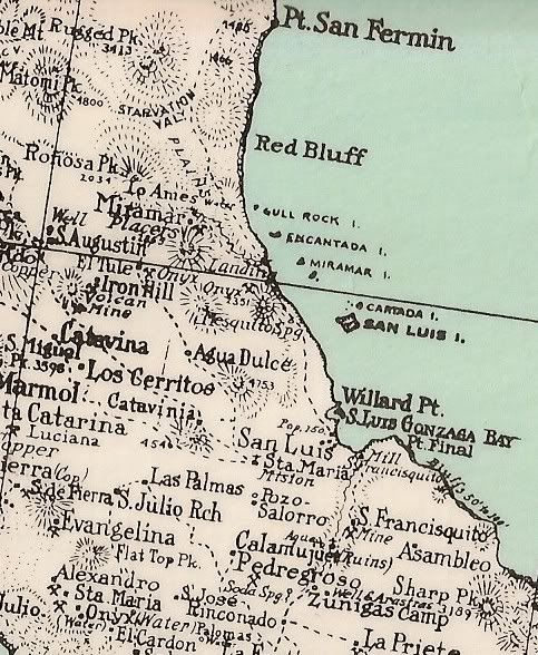
Perhaps the best clue is one garnered from an old Jesuit map. Dated 1757, the Venegas map identifies a point on the Gulf named 'Aguage Santa Isabel.'
Aguage, translated, means 'a place where ships go for water [more accurately a waterhole].' The Jesuit map further mentions an area south of the San
Pedro Martir range, below the present port of San Felipe, which it identifies as 'the Sierra Santa Isabel.'
If the Dominican priests actually did choose to hide treasures in a land they would be departing, it is conceivable that the hiding place would be one
that future members of their Order could identify by a recognizable name. Santa Isabel on Baja was located directly opposite the rich missions in
Sonora on the Mexican mainland shore of the Gulf of California, thus conveniently situated for the gathering of riches from both the Dominican's own
as well as those of former Jesuit Baja California missions. At that time the Peninsula was still virtually unmapped and the Venegas map was in common
use.
To further confirm this possibility, my exploration team compared the shoreline of a modern map with that of the ancient one and found that Agauge
Santa Isabel on the old map matches the shoreline of Bahia San Luis Gonzaga on modern maps (now a popular fishing port). A deep arroyo extending
inland in a southwesterly direction from the south end of Gonzaga Bay toward 'Cerro Isabella,' as identified on modern maps, would be a tempting place
to begin a search for the Santa Isabel Mission stash, if such ever existed.
So now let's consider the Santa Clara lost mission legend.
To early visitors who crossed Baja's Vizcaino Desert, the change today is astonishing. Land that used to wallow in dust now blooms with vigor. Like
Southern California's Imperial Valley, fed by the All American Canal from the Colorado River, all the incredibly rich soil of Baja's parched Vizcaino
Desert needed was water to bring it alive. Mexico's government found a solution in the late 1960's when it pioneered a drip irrigation system
utilizing 'fossil water.' Many thousands of years old, the water is not from recent rains, but rather is water percolated into the substrata during
an age when water was plentiful, possibly before the last Ice Age. Once gone, however, it cannot be replaced. Tests indicate sufficient reserves for
the future with conservation. Living fences along the highway prove the richness of the soil, their posts having taken root to sprout decorative,
leafy tops.
Dauntless explorers in four-wheel-drive vehicles have struggled through Vizcaino's deep sands to the beach of Malarrimo, where oblique currents have
heaped centuries of maritime refuse into dunes. Others have inhaled the dust of the Sierra Pintada, or scaled the rugged cliffs west of San Ignacio,
or risked their boats against the rocky shore of Cedros Island, but only a few of us have flown low above the jagged red rocks that torture the clay
mantle that holds the Santa Clara range in place, drawn there by the legend of the Santa Clara's mission treasure.
There are two reasons for this. One is that it lies in the most formidable, uninhabitable area of the peninsula. The other is that the legend of the
lost Santa Clara Mission in relatively unknown. As previously related, time has confused with the Santa Isabel lost mission legend on the Gulf Coast.
Conversely, Santa Clara is on the Pacific side of the peninsula. It is believed to have been hastily constructed in 1767 from an unfinished Jesuit
mission that had been begun a decade earlier near gold mines once worked by mission Indians in the Sierra Pintadas.
But let us start at the beginning of the Jesuit story.
In 1697, two Jesuit missionaries and sixteen soldiers arrived at Loreto to institute a mission system that would last over a period of seventy years.
By the time of their expulsion, fifteen Jesuit priests and one lay brother had died and were buried in Baja California, while exactly that same number
left the peninsula. Although their expulsion was intended to come as a surprise, the royal decree to banish Jesuits from the Spanish empire was read
in Mexico City on June 24, 1767, but not executed until five months later when Captain Gaspar de Portola entered the port of San Bernabe at the very
tip of the peninsula to initiate seizures. Even taking into account the slowness of communications in that day, it is hard to believe that the
powerful Jesuits would not have maintained spies both in the courts of Spain and Mexico City who could have sent a timely warning. Tension with the
Crown had seethed for a number of years over rumors that the Jesuits forced Indian labor to exploit mines and pearl fisheries, thus depriving the
Crown of its Royal Fifth.
Further evidence of Jesuit foreknowledge was observed by the King?s visitor general Jose de Galvez, who noted that the Jesuits destroyed certain
mission records and that the missionaries had not purchased their customary supplies in the period previous to the expulsion. The Franciscans, who
replaced the Jesuits, had already taken measures to fill their places and administer their estates before sailing from the mainland to assume their
new stations.
According to legend, when forewarned in advance of King Carlos' edict to expel them, the Society of Jesus sent orders from Rome to safeguard the
Order's treasures in a secret mission in the most inaccessible spot possible until such time as representatives of the Order could return and ensure
its proper use in the name of the Jesuits. Treasures estimated to be worth up to $8 million included hoards of pearls, silver, gold, and personal
wealth. Accordingly, the Jesuits secreted their treasures in a remote unfinished mission, blocked its entrance with a landslide, planted cacti in the
trail leading to it, and destroyed any sign of its presence. Indian converts who labored to accomplish this end were either killed or sworn to silence
with a perpetual curse of violent death upon betrayal.
Members of the Jesuit Order emphatically deny the actual existence of treasure to this day. While modern Jesuit apologists apparently consider it
unattractive for their eighteenth-century brethren to have garnered wealth, those of the time took pride in the beauty and richness of their missions.
So did the patrons who subsidized the holy fathers in order to insure for themselves a final benediction. The Marquis de Villapuente, possessor of
broad estates in Tamaulipas on the East Coast of Mexico, contributed tens of thousands of pesos to the fund, which, along with other contributions,
yielded a substantial income from investments in large haciendas and plantations. At that time, there was questionable propriety in the death of a
Catholic of means who neglected to remember the missions in his will.
And yet when the Franciscans took over, where were the 'golden chalices, sacred vessels of gold, precious vestments, golden altars, images adorned
with pearls' and other ecclesiastical paraphernalia described by the Jesuit Father Baegert while he was in charge one of the missions there? It seems
odd that the treasury inherited by the Franciscans was relatively bare. Nevertheless, a few published inventories of mission goods turned over by the
Jesuits to the newly arrived Franciscans do exist. All churchly appointments described in those inventories were made of silver.
With only five months warning, the Jesuits would have had to work fast to send runners over the length of the mission chain to arrange a treasure
cache, but by utilizing a known location in a central region, it could have been accomplished.
Santa Clara had already been explored and pegged for a mission. According to Fernando Ocaranza's Cronicas y Relaciones del Occidente de Mexico, a
missionary from San Ignacio recommended the founding of a new mission there in 1737 in response to a request from the friendly Walimea tribe in the
area. In another reference, Venegas reported that the project was discussed in an official Jesuit report dated 1745 in order to Christianize wild
Indians in the western area of the peninsula so none would be at their backs while they continued the mission chain to the north. A map in this same
volume shows a mission located in the Santa Clara region called San Juan Bautista, while another Jesuit map dated 1757 notes a projected mission of
that name in the Santa Claras. Mission San Juan Bautista is indeed a lost mission. If a secret Jesuit mission cache existed in the Santa Clara
Mountains, Mission San Juan Bautista is it. Although listed as last among the sixteen missions reported in 1745 by the Jesuit fathers in Baja
California, it was ignored on the mission inventory inherited by the Franciscans.
A requisite to a Jesuit treasure cache would be a location to which the Order could return later by sea, undetected from populated areas. Explorations
of the Pacific Coast had been instituted by the Order as early as 1721 when Father Juan de Ugarte equipped an expedition to find a port for the
Philippine galleon. His full report was in the hands of the Jesuits, with maps and explanations of three suitable Pacific harbors with sufficient
timber and fresh water. One of these was convenient to the Santa Claras.
In 1745 the Father Provincial ordered a report describing the status of mission stations. It was stated in this document that the mission at San
Ignacio, directly east of the Santa Clara range, supported eight mission stations radiating from distances of three to eleven leagues from San
Ignacio. In which direction they lay was not indicated, but the two most distant were Santa Marta at eleven leagues and Santa Lucia close to the
foothills of the Santa Claras. Considering the unusual friendliness of the Walimea Indians in this region, together with its proximity to a good port
on the Pacific coast, it is possible that the Jesuits used the visita they had started there for temporary shelter while they hastily constructed a
cache for treasure (which they referred to as the Santa Clara Mission to their unsuspecting Indian helpers). A further advantage to a mission cache
located in this area, and one that may have been well known to the Jesuits, is that it lay in a region rich with gold.
It is known that by 1765 the Jesuits had visited the sharp peaks of the Santa Clara Mountains. Padre Sigismundo Taraval, for one, had drunk from the
waters at San Angel as well as those of Ojo de Liebre while en route, heedless of the 'red insects' in the latter, and had continued on to the coast
eventually reaching Cedros Island.
The Santa Clara region consists of a confusing mountain mass. Eons ago, when the Vizcaino Desert was submerged by the sea, two adjacent ranges formed
part of a long group of islands of which Cedros, Natividad, and San Benito are the existing representatives. In time, the two adjacent ranges acquired
different names, one Santa Clara, the other Sierra Pintada.
In a 1907 map, Arthur North lumps them together under 'Sierra Pintada.' However, miners in the 1900s differentiated between them, albeit like the
natives, indiscriminately. Written accounts and maps of this isolated area are relatively scarce, with the mapmaker's information varying with the
tradition of his informant. At one place, only a narrow pass separates the two ranges. Unfortunately, early perpetrators of the legend of the Santa
Clara mission failed to consider which name modern geographers would give to which range.
The Santa Clara range has not been exploited, but in the 1890s a National Academy of Science expedition led by Edward Goldman made a brief side trip
into it to search for antelope. At San Angel, where Padre Nicolas Tamaral had found water, Goldman found a deserted ranch. In a shallow arroyo beside
springs that gave abundant water, they found date palms and other plants which made it a pleasant place to camp. Could these palms have been planted
to shade the missionaries while their Indians worked secret mines?
Water in the Pintada range is also scarce. There are only two known sources. One is presently a small ranch close to the north of the range, San Jose
de Castro. The other is San Andres, a ranch and old mining camp just south of the Sierra Pintada. A legend that the Indians had collected ?gilt
stones? for the priests in this area is what led to the gold discovery there in 1893, which lasted for ten years and produced $75,000 in placer gold.
There are still rich placers in the vicinity, but its extreme isolation put an end to mining long ago.
During the gold rush to the Pintadas, miners concentrated on the western slope, ignoring the eastern slope and the side of the pass now designated as
the Santa Clara. An old trail from San Ignacio via San Angel is visible from the air through this pass, however. The most promising search would be
one working both ends to the middle, launched from the pass that divides this single range with two interchangeable names.
It is unlikely that the Santa Clara Mission would consist of more than a rock shelter with thick walls and a deep foundation for securing and
protecting the treasure. Only the subtle clues of proximity to water and stone chippings left by Indian workers would say to an astute treasure
seeker, 'Dig here!'
For me personally, treasure hunting is not an end itself. Whether or not the vast riches of lost missions ever existed in fact is unimportant. What
is important is how they stimulate our interest in Baja California history today. Having had the thrill of discovering two lost mission sites now
officially recognized and first identified in my earlier Baja California book and in Desert magazine, the challenge of proving true the old Santa
Clara legend remains a project for future historians.
--------------------------------------------------------------------------------------
For more on Choral Pepper: http://choralpepper.com
|
|
|
wilderone
Ultra Nomad
Posts: 3906
Registered: 2-9-2004
Member Is Offline
|
|
"...remain a secret with so many prospectors covering those hillsides the past 100+ years"
The Great Murals were a "secret" for 1000s of years. The miners would not have cared about any old stone walls or would not have done anything about
them if one did decide to do any intellectual analysis regarding their origins.
The standing pools to the right of the El Volcan junction, about 1/4 mi. down the arroyo, come from numerous seeps in the cliffs - I've seen them. I
pumped this water through my Sweetwater filter and it was still too mineralized to drink. There are bubbling underground springs in the new onyx hill
and in some of the standing pools - I've seen them. The water table would not make much difference to people or animals living here - I doubt there
was much drilling for water of any sort. However, there may be have been much water collection and storage. This arroyo is simply a water course
created by sporadic rainstorms (found all over Baja); there would be resultant fresh water-filled tinajas for some weeks afterward for animals. I
would opine that the people who inhabited this area did so for hunting the sheep and other animals who came for the water source; the mineral pools
would also offer some means of hygiene, and possibly certain plants grew here and nowhere else.
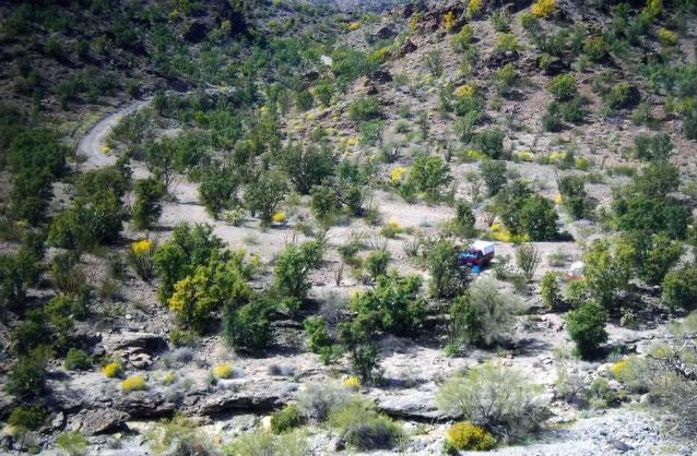
From these photos I could see where a Google image might produce an illusion of turrets or arches or steps in places, given the numerous rock outcrops
and fracturing of the rock cliffs (at the junction and immediately to the right of the junction):
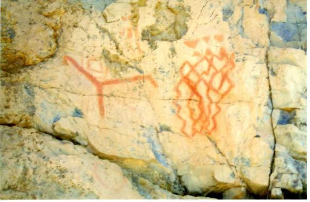
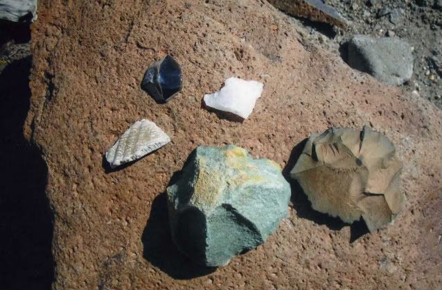
For sure, there were people here:

I hope the recent grading has improved erosion like this:
|
|
|
elbeau
Nomad
Posts: 256
Registered: 3-2-2011
Location: Austin, TX
Member Is Offline
|
|
| Quote: | Originally posted by wilderone
From these photos I could see where a Google image might produce an illusion of turrets or arches or steps in places, given the numerous rock outcrops
and fracturing of the rock cliffs (at the junction and immediately to the right of the junction) |
Those are great photos wilderone! thanks.
I would have to agree that from that first photo especially, it is likely that outcroppings as rich in color and texture as these could trick our eyes
into seeing things that aren't there. I really do love that first photo. Even if this and other evidence finally produces the answer that this is
just a geologic phenomenon, I still find the geology intriguing enough that I would like to put all this together and document it. With your
permission I would like to add your photos to the Google Earth overlay I made of Tom and Bill's arroyo trip.
|
|
|
jimgrms
Senior Nomad
Posts: 664
Registered: 9-30-2005
Location: oceanside ca
Member Is Offline
Mood: its always good
|
|
are you the guy who was raising funds in San Felipe to float your,, styrafoam raft to china ?
|
|
|
wilderone
Ultra Nomad
Posts: 3906
Registered: 2-9-2004
Member Is Offline
|
|
"I would like to add your photos to the Google Earth overlay
Sure.
|
|
|
David K
Honored Nomad
Posts: 65549
Registered: 8-30-2002
Location: San Diego County
Member Is Offline
Mood: Have Baja Fever
|
|
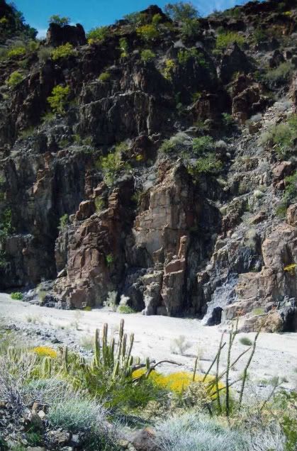
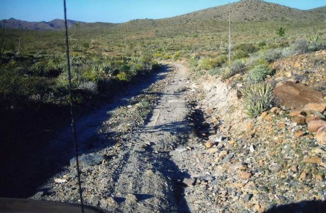
Nice photos Wilderone... glad you shared the rock art too... Arroyo el Volcan is highly interesting to be sure...
For those of you with the Baja Almanac or topo maps, this is mis-named as Arroyo Zamora on them... and another arroyo just south carries the name El
Volcan (in error).
On maps made about 100 years ago by American prospectors, the arroyo was given the name 'Tule Wash'.
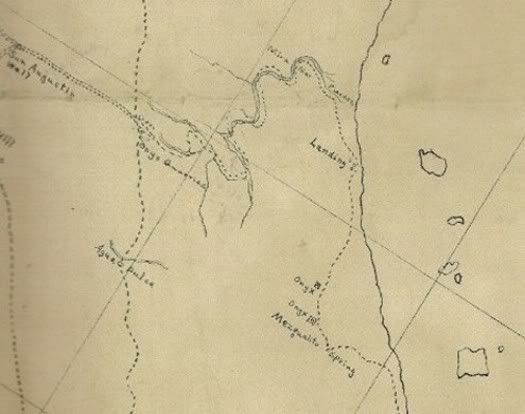
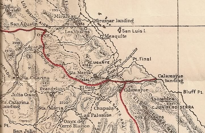
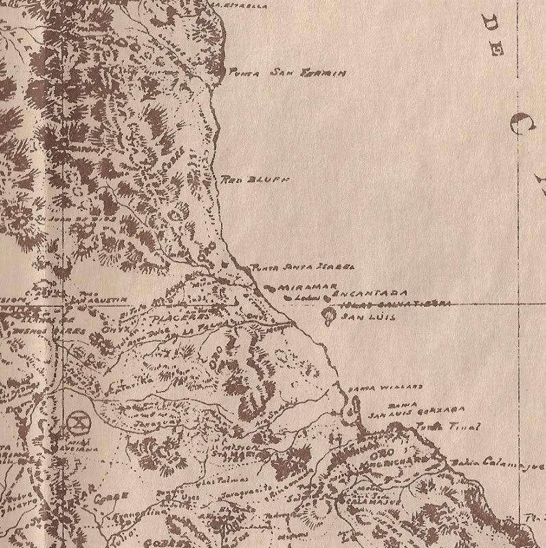
Note that El Volcan was a regular trail route from 'onyx' (El Marmol) to the gulf:
1905:
1905-1919:
1919:
1930:
[Edited on 3-30-2011 by David K]
|
|
|
elbeau
Nomad
Posts: 256
Registered: 3-2-2011
Location: Austin, TX
Member Is Offline
|
|
I think I understand the "mission site" much better after viewing it some more today. I'm working on posting a major revision of what I see at the
site, so please hold onto that skepticism until I get this done. It will take some real explaining on my part, and I assure you, you will find a
target-rich environment for skepticism, but once the site is visited, I think this will play out much better than my previous posts.
|
|
|
mtgoat666
Platinum Nomad
Posts: 21061
Registered: 9-16-2006
Location: San Diego
Member Is Online
Mood: Hot n spicy
|
|
| Quote: | Originally posted by David K
...a secret repository for the Jesuit treasures...
...a simple room or a cave,... |
the legend dreams on!
|
|
|
TMW
Select Nomad
Posts: 10659
Registered: 9-1-2003
Location: Bakersfield, CA
Member Is Offline
|
|
That would have been a very difficult trip. From the maps I see they were out of the wash several times. I've been down the wash about a mile further
than our site and there is maybe a 30 foot angle drop with large boulders. That route they took must have been one heck of a route to go over. Is
there any written info on the route?
|
|
|
David K
Honored Nomad
Posts: 65549
Registered: 8-30-2002
Location: San Diego County
Member Is Offline
Mood: Have Baja Fever
|
|
Right... it parallels the wash, but seems to be above it rather than in it except where it crosses it. No story about it in my books, I looked!
|
|
|
elbeau
Nomad
Posts: 256
Registered: 3-2-2011
Location: Austin, TX
Member Is Offline
|
|
Those shadowy sections uphill from my proposed "mission site" have always defied any logic I ever tried to apply to them. The best I could guess is
that it was either a North West facing slope, like all the other shadowy areas you see in GE, but the drainage and shadows just didn't ever come
together for that. I also thought that it might be thick vegetation of some kind, but that never looked right either. But today I think I started to
understand them.
It's hard to try to reconstruct the details of this, but only because the event would have been pretty destructive...but here's the basic idea:

And here's a VERY, VERY, VERY, VERY imprecise, rough guess to help you see what I'm thinking happened at some point:

|
|
|
David K
Honored Nomad
Posts: 65549
Registered: 8-30-2002
Location: San Diego County
Member Is Offline
Mood: Have Baja Fever
|
|
| Quote: | Originally posted by elbeau
Those shadowy sections uphill from my proposed "mission site" have always defied any logic I ever tried to apply to them. The best I could guess is
that it was either a North West facing slope, like all the other shadowy areas you see in GE, but the drainage and shadows just didn't ever come
together for that. I also thought that it might be thick vegetation of some kind, but that never looked right either. But today I think I started to
understand them.
It's hard to try to reconstruct the details of this, but only because the event would have been pretty destructive...but here's the basic idea:
And here's a VERY, VERY, VERY, VERY imprecise, rough guess to help you see what I'm thinking happened at some point:
|
Good evening Elbeau... did you have a chance to read Choral Pepper's chapter I reposted just above?
She would have loved to be here now and fan the excitement that the mysteries and myths of Baja's lost Santa Isabel mission give, that you have
brought back to life on Nomad.
Another historic mystery that was the subject of great study and writings of another 'Baja person'... my late amigo Dave Deal.
Dave was a Baja racer, pilot, and world famous cartoonist... His last famous work was for the Pixar film 'Cars' in which he created nearly all the
characters for. Dave passed away not long ago, but before he did his studies on the final resting spot for Noah's Ark were well documented on one of
his web sites.
Dave's use of the satellite images of landslides totally reminds me of your images above... Enjoy Dave Deal's explanations and illustrations here and
the linked web pages: http://www.noahsark-naxuan.com/1.htm
|
|
|
elbeau
Nomad
Posts: 256
Registered: 3-2-2011
Location: Austin, TX
Member Is Offline
|
|
| Quote: | Originally posted by David K
| Quote: | Originally posted by elbeau
Those shadowy sections uphill from my proposed "mission site" have always defied any logic I ever tried to apply to them. The best I could guess is
that it was either a North West facing slope, like all the other shadowy areas you see in GE, but the drainage and shadows just didn't ever come
together for that. I also thought that it might be thick vegetation of some kind, but that never looked right either. But today I think I started to
understand them.
It's hard to try to reconstruct the details of this, but only because the event would have been pretty destructive...but here's the basic idea:
And here's a VERY, VERY, VERY, VERY imprecise, rough guess to help you see what I'm thinking happened at some point:
|
Good evening Elbeau... did you have a chance to read Choral Pepper's chapter I reposted just above?
She would have loved to be here now and fan the excitement that the mysteries and myths of Baja's lost Santa Isabel mission give, that you have
brought back to life on Nomad.
Another historic mystery that was the subject of great study and writings of another 'Baja person'... my late amigo Dave Deal.
Dave was a Baja racer, pilot, and world famous cartoonist... His last famous work was for the Pixar film 'Cars' in which he created nearly all the
characters for. Dave passed away not long ago, but before he did his studies on the final resting spot for Noah's Ark were well documented on one of
his web sites.
Dave's use of the satellite images of landslides totally reminds me of your images above... Enjoy Dave Deal's explanations and illustrations here and
the linked web pages: http://www.noahsark-naxuan.com/1.htm |
Yes, yesterday I read all the way through Choral Pepper's chapter that you posted. I love it! It's not hard to find one version of a legend or
another version of a legend, but having her kind of put them all together and give her experienced interpretation and summary of them is really good
reading. It tends to bring the stories together and ground them in more reality and I like that.
I also read through much of Dave's Noah's Ark research. That's a fun read too. Those stones that they're calling anchors in the photos appear to
have some writings on them. Do you know if anybody has any ideas about what they say?
|
|
|
David K
Honored Nomad
Posts: 65549
Registered: 8-30-2002
Location: San Diego County
Member Is Offline
Mood: Have Baja Fever
|
|
No, I don't know what is written on the anchor stones (it may have been added after 'Noah' used them)... However, I did hear that geologist confirm
the stones did not come from where Noah built the ark, but from nearby mountains to where they now are. Of course, all is in dispute... as much
history always will be as no one was alive still from when it happened!
|
|
|
wilderone
Ultra Nomad
Posts: 3906
Registered: 2-9-2004
Member Is Offline
|
|
Originally posted by David K
...a secret repository for the Jesuit treasures...
...a simple room or a cave,...
In one of Erle Gardner's books he tells of coming across a prospector in Baja on one of his trips who approached Gardner and asked for funding to
excavate a cave which he discovered, and which he believed contained lost Jesuit treasure. The cave, he explained had suffered a landslide and the
entrance was blocked. Gardner was skeptical and declined to finance the venture. At some point later, Gardner received in the mail a photograph of
some of the treasure - no other communication or details.
Given the volatile geographic elements and seismographic (sp?) capability of the El Volcan area, I think landslide evidence must be considered.
|
|
|
Jack Swords
Super Nomad
Posts: 1097
Registered: 8-30-2002
Location: Nipomo, CA/La Paz, BCS
Member Is Offline
|
|
Just to keerp this thread current: Here is another explanation about the Lost Mission Isabel (ysabel) from Greg Niemann's book Baja Legends. If I
didn't have our annual trip to Death Valley and W. Nevada ghost town/4X4 trip planned for the end of April, I'd be there. Success or no, I love that
area having hiked all over, down the arroyo, found remnants of an old plane crash, absorbed the history.
http://books.google.com/books?id=35WQOduN1F4C&pg=PA35&am...
|
|
|
| Pages:
1
..
10
11
12
13
14
..
23 |
|


