| Pages:
1
..
11
12
13
14
15
..
23 |
David K
Honored Nomad

Posts: 65549
Registered: 8-30-2002
Location: San Diego County
Member Is Offline
Mood: Have Baja Fever
|
|
| Quote: | Originally posted by wilderone
Originally posted by David K
...a secret repository for the Jesuit treasures...
...a simple room or a cave,...
In one of Erle Gardner's books he tells of coming across a prospector in Baja on one of his trips who approached Gardner and asked for funding to
excavate a cave which he discovered, and which he believed contained lost Jesuit treasure. The cave, he explained had suffered a landslide and the
entrance was blocked. Gardner was skeptical and declined to finance the venture. At some point later, Gardner received in the mail a photograph of
some of the treasure - no other communication or details.
Given the volatile geographic elements and seismographic (sp?) capability of the El Volcan area, I think landslide evidence must be considered.
|
The person with the lost mine who wanted Gardner to buy into was Jesus Flores:
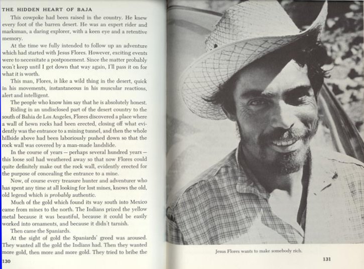
Jesus Flores who has a secret (lost) mine, has an entire chapter in Gardner's book. In 2001, he was our guide searching for the lost mission (www.vivabaja.com/van1). Both are still lost!
(At the time, I didn't realize it was the same person who guided Gardner, 40 years earlier!)
Since I made the web page of my 2002 trip, the lost mission was found... but I hadn't heard about the lost mine being found.
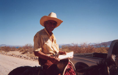
Here is Jesus in 2002, riding past Camp Gecko:

I naturally asked him to autograph his photo in my copy of Gardner's book (which I brought with me, just in case):
(Baja is just a great big adventure and wonderful experience!)  
|
|
|
elbeau
Nomad
Posts: 256
Registered: 3-2-2011
Location: Austin, TX
Member Is Offline
|
|
| Quote: | Originally posted by Jack Swords
Just to keerp this thread current: Here is another explanation about the Lost Mission Isabel (ysabel) from Greg Niemann's book Baja Legends. If I
didn't have our annual trip to Death Valley and W. Nevada ghost town/4X4 trip planned for the end of April, I'd be there. Success or no, I love that
area having hiked all over, down the arroyo, found remnants of an old plane crash, absorbed the history.
http://books.google.com/books?id=35WQOduN1F4C&pg=PA35&am... |
I'd love to know the areas you've hiked and explored and hear your details and impressions of the area. Also, do you have any photos from your trip?
Where was the old plane crash?
|
|
|
mtgoat666
Platinum Nomad
Posts: 21063
Registered: 9-16-2006
Location: San Diego
Member Is Offline
Mood: Hot n spicy
|
|
if such truly existed, he could have dug it out by hand in the 40 years you speak of.
it is either gone or was never there.
i encourage you to go for it, explore away!
but take a bottle of water, we don't want you getting any more delirious than you already are!
|
|
|
David K
Honored Nomad
Posts: 65549
Registered: 8-30-2002
Location: San Diego County
Member Is Offline
Mood: Have Baja Fever
|
|
| Quote: | Originally posted by elbeau
| Quote: | Originally posted by Jack Swords
Just to keerp this thread current: Here is another explanation about the Lost Mission Isabel (ysabel) from Greg Niemann's book Baja Legends. If I
didn't have our annual trip to Death Valley and W. Nevada ghost town/4X4 trip planned for the end of April, I'd be there. Success or no, I love that
area having hiked all over, down the arroyo, found remnants of an old plane crash, absorbed the history.
http://books.google.com/books?id=35WQOduN1F4C&pg=PA35&am... |
I'd love to know the areas you've hiked and explored and hear your details and impressions of the area. Also, do you have any photos from your trip?
Where was the old plane crash? |
I have hosted many of Jacks photos on my site for 10 years... He recently sent me more I need to have added. Enjoy them (originally many seperate
pages, but are linked together now: http://vivabaja.com/swords
|
|
|
elbeau
Nomad
Posts: 256
Registered: 3-2-2011
Location: Austin, TX
Member Is Offline
|
|
| Quote: | Originally posted by David K
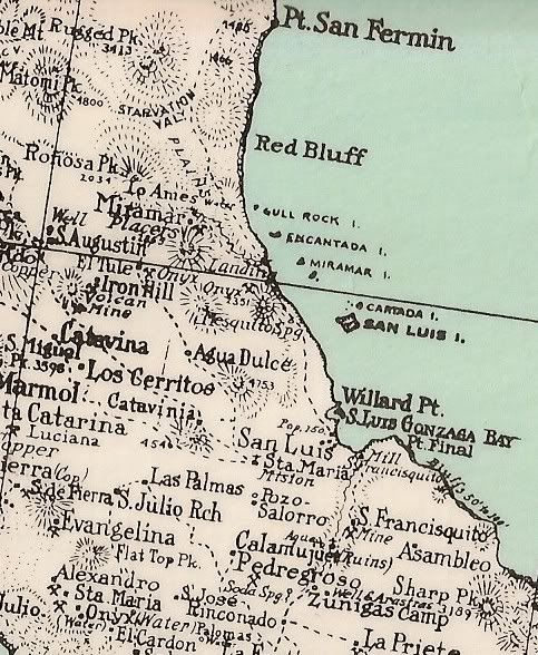
Nice photos Wilderone... glad you shared the rock art too... Arroyo el Volcan is highly interesting to be sure...
For those of you with the Baja Almanac or topo maps, this is mis-named as Arroyo Zamora on them... and another arroyo just south carries the name El
Volcan (in error).
On maps made about 100 years ago by American prospectors, the arroyo was given the name 'Tule Wash'.
Note that El Volcan was a regular trail route from 'onyx' (El Marmol) to the gulf:
1905:
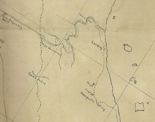
|
You've got to give credit to the accuracy of whoever made that map. It lined up with three onyx quarries and the chain of islands fantastically.
This gives you a great idea of exactly where the old "El Tule" trail went. Even those of you who are following this thread who think I'm crazy
because of the Santa Isabel thing must admit that doing a trip down that old trail is a worthy adventure someday.
DK, I haven't heard anything about those two onyx quarries on the East side of the range. How well are they known?
KML File

|
|
|
elbeau
Nomad
Posts: 256
Registered: 3-2-2011
Location: Austin, TX
Member Is Offline
|
|
Also, a lot of features of that map match up well, but not the shoreline. It's only been 106 years, does the Eastern Baja shoreline change that
rapidly? Or is the map or my alignment of it wrong?
|
|
|
bryanmckenzie
Senior Nomad
Posts: 561
Registered: 9-23-2009
Location: 400 Km from Mexico Beach, Florida
Member Is Offline
Mood: Hot & humid --- not hot & dry.
|
|
Rebuttal to Elbeau's Rebuttal to my rebuttal
Apologies for the silence. I've been away for 2 days on personal matters & am just now getting back into the fray. Me thinks I'm going to put many
Nomads to sleep with my continued 'lecture series.' So if you're no longer interested, I take no offense.
Thanks David; not withstanding that this is apparently a NOT remote area and that miners, Nomads, ATV's and many people have passed
through this arroyo for more than a century ... I'd actually enjoy a day trip out here, poking around for the first time and sending postcards back to
the family. And mostly meeting my fellow Nomads, many whom I've not yet met.
"I would really like to make sure that the feedback makes it into this nomad thread" ... http://bbs.keyhole.com/ubb/ubbthreads.php?ubb=showthreaded&a...
"I REALLY don't think there's much of a chance of finding any treasure whether it ever existed or not...but not only is it fun to look into these
stories, but who know what we might find along the way." ... AGREED
"I can't explain why they would exist going up a hill" ... of course you can't ... those arches CANNOT exist in the first place, much less
exist beyond everything else. The arch pictures demonstrate this; arches come in all shapes and sizes --- BUT each footing MUST be at the same
elevation (horizontal ground). Here, let's go back to square one --- "one downside is that an arch pushes outward at
the base, and this needs to be restrained in some way, either with heavy sides and friction or angled cuts into bedrock or similar."
Hence, if one end is higher than the other, the higher end blows the lower end out; ref.: http://en.wikipedia.org/wiki/Arch#Technical_aspects
"you're trying to rule out the possibility of their existence" ... they never existed, they could not have been constructed, or is there an
anti-gravity machine I'm not aware of; ref.: http://en.wikipedia.org/wiki/Arch#Technical_aspects
"your questions about the arch, they are constructive to this conversation and have a logical basis, but I'll also bet that you'll agree that
ancient unknown civilizations can surprise us." ... yes, they understood gravity; ref.: http://en.wikipedia.org/wiki/Arch#Technical_aspects
"it's worthy of a day hike and a few good photos" ... AGREED, I said I'd go for the sunshine and adventure
"do you see the landslide?" ... no, I see erosion/gullies on either side of your arrow
"it really confuses me how both you and DK think that the water argument has been made to such a point that you can use it as evidence against the
possibility of an ancient culture in the arroyo area." ... very simple Elbeau --- look at every other mission site; the good friars chose
locations (sometimes moved once, or even twice) that had CONTINUAL water, SURFACE water or GROUND water that could have been just a few feet below the
surface. HOW DID THEY KNOW? Look for mature vegetation. Trees, palm oasis, whatever. Ref.: Mulege, San Ignacio, La Paz, El Rosario, etc., all situated
in arroyos that indicated to them that this was a location with a reliable fresh water source. If I'm going to grow food, conquer savages and flush my
toilet, I need water. So I looks for where trees and shrubs are growing naturally.
"it may not be as dry as previously assumed either" ... see above & this from Wilderone ... "This arroyo is simply a water course created
by sporadic rainstorms (found all over Baja)" ... for the entire post
if water sources were here, they were (are) intermittent, not perennial.
"Finally, there never was the time and energy to collect treasures or mine gold by the Jesuits or their Indians... they barely could feed
themselves, so all energy went into food production." ... thanks David; I make the point not because I'm the expert, but take a
read from THE expert in Jared Diamond's book "Collapse: How Societies Choose to Fail or Succeed" which covers this topic in glorious detail.
Back to tunnels in the earth from a camera on a satellite at 20,000 miles above the earth in geo-synchronous orbit --- yes, I know the CIA
et al can read license plates from up there if they want to, but this is us civies using commercial products for dummies --- but if you
can see a cave or tunnel ... what can I say, that logic on these images is right up there with my buddy the Road Runner (and I love him) you're going
to need a wee bit o' dynamite to make that a reality ... 
Lastly Elbeau, the question remains --- that no one yet has asked (unless I missed it) --- how is it that
you arrived at these particular coordinates at this tiny geographic location??? And then postulated this theory? I'm not even sure
after several Margaritas that I'm using those words correctly.
Good night. Im pooped. And my head hurts.
[Edited on 2011-4-1 by bryanmckenzie]
âTravel is fatal to prejudice, bigotry, and narrow-mindedness.â
-Mark Twain
Samuel Langhorne Clemens (November 30, 1835 â April 21, 1910)
|
|
|
David K
Honored Nomad
Posts: 65549
Registered: 8-30-2002
Location: San Diego County
Member Is Offline
Mood: Have Baja Fever
|
|
What fun this is!
elbeau, I recommend getting a copy of the Lower California Guidebook by Gulick and Gerhard... last printing was 1970 (1967 edition) or the 1962
edition (or 1964 printing of it).
The spring 'Agua del Mezquitito' is on the 1905 map, as well as being in one of the lost mission stories.
In the 1980 book Rockhounding in Baja by W.R.C. Shedenhelm (La Siesta Press) on page 29: ... 33 miles south of Puertecitos, there is yet another
deposit of calcite onyx in a canyon called "Tule Arroyo."
In the 1970 guidebook 'Baja California Mexico' by Cliff Cross on page 80: 33 (miles from Puertecitos, 4 from Okie Landing): Onyx mine on the hillside,
to right.
Here is Cliff's map:
(Agua del Mezquitito is 2.4 miles south of Okie Landing)
Lower California Guidebook map:
----------------------------------------------------------------------
Bryan... good to have you scientific eye here!
[Edited on 4-1-2011 by David K]
|
|
|
David K
Honored Nomad
Posts: 65549
Registered: 8-30-2002
Location: San Diego County
Member Is Offline
Mood: Have Baja Fever
|
|
| Quote: | Originally posted by elbeau
Also, a lot of features of that map match up well, but not the shoreline. It's only been 106 years, does the Eastern Baja shoreline change that
rapidly? Or is the map or my alignment of it wrong? |
It was a hand drawn map... I would read nothing into the shoreline location being off...
|
|
|
David K
Honored Nomad
Posts: 65549
Registered: 8-30-2002
Location: San Diego County
Member Is Offline
Mood: Have Baja Fever
|
|
Onyx/ Soda Springs
There are a few soda springs in Baja where onyx is being made... most are between Puertecitos and Gonzaga Bay. El Marmol is only a dozen miles west of
the gulf shore, as the crow flies.
There is a huge soda spring overlooking Gonzaga Bay and there was even some pieces of onyx laying about at the site. My son and I went there in 2002:
It took a few tries to find it (it can be seen from the beach, but that is a few miles away).
Hiking up the right arroyo, the lower end of the field looks like a glacier... only that isn't ice!:
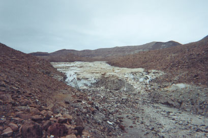
Up further the spring deposit is giant, view west:
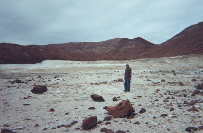
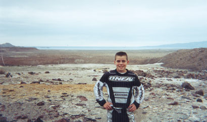
My son, 13 then with the sea in the distance, view east:
Baja is filled with magic places like this!
(if you find the onyx springs, please avoid walking on the crystal layers... also requested by a fellow Nomad to not post the GPS online.)
|
|
|
elbeau
Nomad
Posts: 256
Registered: 3-2-2011
Location: Austin, TX
Member Is Offline
|
|
| Quote: | Originally posted by David K
... also requested by a fellow Nomad to not post the GPS online. |
Removed from KML
|
|
|
mtgoat666
Platinum Nomad
Posts: 21063
Registered: 9-16-2006
Location: San Diego
Member Is Offline
Mood: Hot n spicy
|
|
| Quote: | Originally posted by David K
There are a few soda springs in Baja where onyx is being made... most are between Puertecitos and Gonzaga Bay. El Marmol is only a dozen miles west of
the gulf shore, as the crow flies.
(if you find the onyx springs, please avoid walking on the crystal layers... also requested by a fellow Nomad to not post the GPS online.)
|
DK:
you keep calling it onyx. then you say soda springs. which is it? onyx is silica (quartz). some people misuse the term onyx and apply the term to
carbonates. i have not been to your onyx locations, so wonder which is it? silicates or carbonates?
fyi, neither mineral deposit is particularly rare, so don't know why you care about keeping it secret.
|
|
|
elbeau
Nomad
Posts: 256
Registered: 3-2-2011
Location: Austin, TX
Member Is Offline
|
|
| Quote: | Originally posted by bryanmckenzie
not withstanding that this is apparently a NOT remote area and that miners, Nomads, ATV's and many people have passed through this arroyo for more
than a century ... |
That's what people keep saying, but other than Tom and Bill's trip a few weeks ago, can you come up with any photos showing the hillsides up from the
arroyo? David continues to be very helpful by both teaching us the known history of the arroyo and providing images, quotes, maps, etc. They are
fascinating, but truthfully, do they show evidence of anybody actually being closer to this site than the El Volcan site? Apparently a few Nomads
have driven down the arroyo on MC's trying to find a route to the Sea of Cortez, but they say they were unsuccessful and that they never went on the
hillsides above the arroyo. My impression of what David had said about El Tule was that it was the old mining road that you are referring to, and it
could have been an old route of some sort, but the maps David provided above do not show the trail going within a few miles of the site. It may not
be terribly remote, and it may have had plenty of human traffic, but that's one thing I've been trying to search for and document and I'm coming up
blank with any evidence of anybody ever having come within sight of the site. Do you have anything to present to back up your assertion that people
have been to that site? If so, PLEASE present it. I've been searching for it and blanket statements like "somebody would have found it" may sound
compelling, but it should be backed up with something. Now, I doubt the site has "never" been visited. There are and have been several mines in the
area. It's logical that someone's been there, but if you're going to accuse me of over-speculation, please don't find yourself guilty of the same.
Like I said before, it's great to have you in the conversation, but please don't assume that I won't expect you to back up what you're claiming to
have disproven.
...I'm not sure where you're going with that one, nobody has responded and the GE BBS post has been relegated to the forum containing mostly alien
conspiracies. It was YOUR suggestion, and I quickly saw the value it could offer and followed through...is there something I'm missing here?
| Quote: | | "I can't explain why they would exist going up a hill" ... of course you can't ... those arches CANNOT exist in the first place, much less
exist beyond everything else. The arch pictures demonstrate this; arches come in all shapes and sizes --- BUT each footing MUST be at the same
elevation (horizontal ground). Here, let's go back to square one --- "one downside is that an arch pushes outward at
the base, and this needs to be restrained in some way, either with heavy sides and friction or angled cuts into bedrock or similar."
Hence, if one end is higher than the other, the higher end blows the lower end out; ref.: http://en.wikipedia.org/wiki/Arch#Technical_aspects |
The thing I see as a possible arch DOES have heavy sides and is on what I think is a small leveling on the hillside. The photo Tom took that I think
shows the top of the "arch" structure (or whatever it is) appears to show the top of it as being level with gravity, not the hillside. Assuming the
sides and bottom follow suit, I don't see how your arguments apply yet.
I also wish that you hadn't skipped over many of your original arguments against the arches. The photos I posted showed clearly that arches can have
purposes beyond being load-bearing and that they are one of the most likely features of a structure to remain standing. Your a civil engineer, I
think you know that's true.
| Quote: | | "do you see the landslide?" ... no, I see erosion/gullies on either side of your arrow |
OK, you see one thing, I see another. I'm fine with that. It's why I'm looking forward to better photos of the site.
| Quote: | | look at every other mission site; the good friars chose locations (sometimes moved once, or even twice) that had CONTINUAL water, SURFACE water or
GROUND water that could have been just a few feet below the surface..."it may not be as dry as previously assumed either" ... see above &
this from Wilderone ... "This arroyo is simply a water course created by sporadic rainstorms (found all over Baja)" ... for the entire post
if water
sources were here, they were (are) intermittent, not perennial. |
Perhaps you missed the converstion about El Volcan? It's just upstream from the site, according to several nomads it is a constant source of water
year-round. I'd like to know the effects of drinking such mineralized water would have on people, but there is water within walking distance of the
site at least. That's an established fact.
| Quote: | | "Finally, there never was the time and energy to collect treasures or mine gold by the Jesuits or their Indians... they barely could feed
themselves, so all energy went into food production." ... thanks David; I make the point not because I'm the expert, but take a
read from THE expert in Jared Diamond's book "Collapse: How Societies Choose to Fail or Succeed" which covers this topic in glorious detail. |
OK, no biggie. I'm not thinking there's buried treasure either. Moot point.
| Quote: | | Back to tunnels in the earth from a camera on a satellite at 20,000 miles above the earth in geo-synchronous orbit --- yes, I know the CIA
et al can read license plates from up there if they want to, but this is us civies using commercial products for dummies --- but if you
can see a cave or tunnel ... |
Like I said explicitly in the beginning, originally and quoted in my response to you, I knew I was really stretching it on those little features. Did
you read my response?
| Quote: | | Lastly Elbeau, the question remains --- that no one yet has asked (unless I missed it) --- how is it that
you arrived at these particular coordinates at this tiny geographic location??? And then postulated this theory? |
It's been asked and answered, but I'll say it again. I love Geology and I sell a great geology iPhone app. This area of green in the middle of the
Sonoran desert caught my attention a while back, then when I ran into a "lost mission" story, I thought of this place. Upon reading the article I
reference in "The Californian", my mind immediately went back to that odd-colored mountain range near the eastern coast which had that leveled-off
looking field I've called the "stone corral" in this post. I googled a little more and came across the magazine article that DK posted on page 1 of
this thread where he drew the "12-mile line" and so I looked around where it went and saw some terrain I couldn't understand. It looked man-made, but
didn't make out what it was without several hours of staring at it from different angles and making a few drawings. At that point I DID think I had
found a real mission, but upon studying the surrounding terrain in GE, I came upon the arches and knew that those certainly weren't mission-area
structures. I spent the next few weeks trying to research the "Zamora Canyon" area, but I was using the modern mis-label of the site and didn't learn
much, except for the fact that there was hardly ANY online documentation of that whole canyon area. Very few photos, and all of those were of El
Marmol, El Volcan, or the Olividada mine. I stared at the blue-colored arroyo a lot and came up with a theory for water conservation. I then tried
contacting educators and industry professionals, with very little results. Only one guy would even hear me out, and he's still fascinated with the
idea as far as I know, but he can't do anything without someone getting some on-the-ground photos to back up what I see.
...so...I joined BajaNomad.com and the rest is history.
In any case, we can speculate back and forth and rebut our rebuttals to our rebuttals all day long and still disagree without more evidence. I
welcome the constructive nature of your arguments, but I'd rather not turn this into a tit-for-tat ego fest like most threads tend to digress into.
Once again I'll say it:
It's either there or it's not. I can't talk it into existence and you can't talk it out of existence. Evidence and documentation is the most helpful
thing I am looking for folks such as yourself to provide.
|
|
|
David K
Honored Nomad
Posts: 65549
Registered: 8-30-2002
Location: San Diego County
Member Is Offline
Mood: Have Baja Fever
|
|
| Quote: | Originally posted by mtgoat666
| Quote: | Originally posted by David K
There are a few soda springs in Baja where onyx is being made... most are between Puertecitos and Gonzaga Bay. El Marmol is only a dozen miles west of
the gulf shore, as the crow flies.
(if you find the onyx springs, please avoid walking on the crystal layers... also requested by a fellow Nomad to not post the GPS online.)
|
DK:
you keep calling it onyx. then you say soda springs. which is it? onyx is silica (quartz). some people misuse the term onyx and apply the term to
carbonates. i have not been to your onyx locations, so wonder which is it? silicates or carbonates?
fyi, neither mineral deposit is particularly rare, so don't know why you care about keeping it secret. |
1) Soda springs flow water charged with a gas that cause it to bubble at the surface. The minerals in this water are what form onyz or marble or
limestone, depending on the form the crystals take on. Because this is one of the worlds largest onyx zones, I (and other authors) assume that today's
soda springs are depositing layers that will become tomorrow's onyx beds. So, we use the terms soda springs and onyx springs because of what they are.
2) From 'The Forgotten Peninsula' by Joseph Wood Krutch c1961:
"This particular kind of stone the geologists prefer to call "onyx-marble" to distinguish it from the agatelike material also called onyx. Like marble
it is essentially a water-deposited limestone but it differs from ordinary marble as much as marble differs from limestone. Limestone is soft; marble
is hard. Onyx is so much harder than either that it takes a high polish; it is very resistant to stain and is often banded with brown, green, or
(exceptionally) with rose-red; yet there is very little chemical difference amongst the three and all are formed in much the same way.
Lime is slightly soluble in water, rather readily so if the water has been acidified by the absorbtion of carbon dioxide gas. When lime laden water
deposits its burden, either because it has evaporated or because it has lost its acidity by discharge of gas, you get a deposit of one sort or
another; limestone, marble, or onyx, depending upon the form assumed by the crystals. ...
Each of these conditions is fulfilled at the springs near El Marmol but obviously the required conditions are so critical that marble, onyx and soft
limestome are all present in different layers. The color banding is the result of various impurities- mostly iron and manganese for the buff, brown,
and mahogany, probably organic material for the green.
The largest of the now active springs, hardly two feet across, seems to be boiling like those one sees in Yellowstone Park, but the bubbles are gas,
not steam, and the water is quite cold. Here and there about it are smaller springs and a few cones of quite soft material built up by still others no
longer flowing. ... Natives call this spot El Volcan..."
3) ", so don't know why you care about keeping it secret.":
>>>... also requested by a fellow Nomad to not post the GPS online<<<
Out of respect for what was aked of me. Despite what some have said, if given a GPS or shown a site by another Nomad,... and asked to not publish it
here or in a book, I honor such requests.
|
|
|
elbeau
Nomad
Posts: 256
Registered: 3-2-2011
Location: Austin, TX
Member Is Offline
|
|
| Quote: | Originally posted by David K
Nice photos Wilderone... glad you shared the rock art too... Arroyo el Volcan is highly interesting to be sure...
For those of you with the Baja Almanac or topo maps, this is mis-named as Arroyo Zamora on them... and another arroyo just south carries the name El
Volcan (in error).
On maps made about 100 years ago by American prospectors, the arroyo was given the name 'Tule Wash'.
Note that El Volcan was a regular trail route from 'onyx' (El Marmol) to the gulf:
1930:
[Edited on 3-30-2011 by David K] |
Here's the 1930 map overlaid as good as I can figure. The coastline has two points anchored correctly, but a lot wrong in-between, but El Marmol and
Santa Maria and other sites line up well, so I think our arroyo is pretty well represented by this map positioning. Again, it's impressive how
accurately these maps were drawn when you consider they were done by hand.
KML File

|
|
|
David K
Honored Nomad
Posts: 65549
Registered: 8-30-2002
Location: San Diego County
Member Is Offline
Mood: Have Baja Fever
|
|
COOL!
I sure like the way you do the overlays of old maps with satellite images... I think I know how to do it, but I have so much stuff going on when I am
online, I am not ready to try.
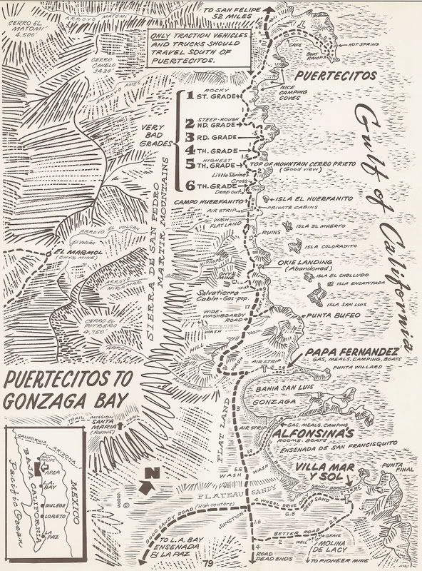
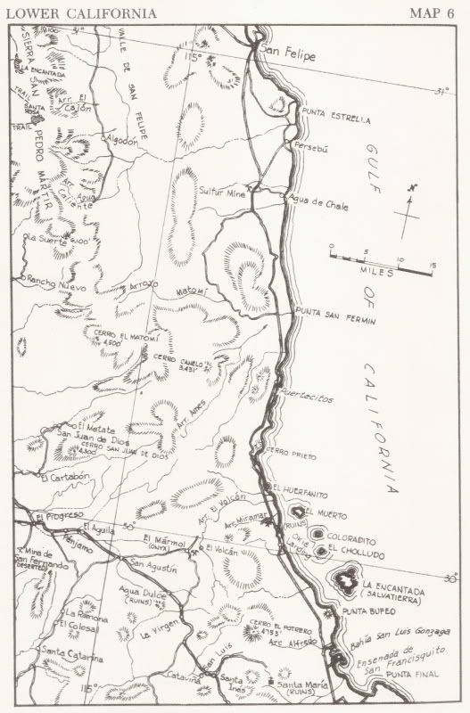
Can you do an overlay of Howard Gulick's map (1962 Lower California Guidebook Map 6) with satellite image, please?
|
|
|
elbeau
Nomad
Posts: 256
Registered: 3-2-2011
Location: Austin, TX
Member Is Offline
|
|
| Quote: | Originally posted by David K
COOL!
I sure like the way you do the overlays of old maps with satellite images... I think I know how to do it, but I have so much stuff going on when I am
online, I am not ready to try.
Can you do an overlay of Howard Gulick's map (1962 Lower California Guidebook Map 6) with satellite image, please? |
Here you go:
KML File

|
|
|
David K
Honored Nomad
Posts: 65549
Registered: 8-30-2002
Location: San Diego County
Member Is Offline
Mood: Have Baja Fever
|
|
Thanks... do you add the color enhancement or is that brown tone the way Google shows how the Earth looks from that elevation?
|
|
|
elbeau
Nomad
Posts: 256
Registered: 3-2-2011
Location: Austin, TX
Member Is Offline
|
|
| Quote: | Originally posted by David K
Thanks... do you add the color enhancement or is that brown tone the way Google shows how the Earth looks from that elevation?
|
I take some steps to enhance the markings on the map and to delete all the other pixels then I overlay the photo in GE and reduce the overlay's
opacity so that you can see through the markings a little and still make out the terrain beneath them. I don't/can't change the color tone of GE
itself.
Each image is different, but for this one I:
*increased gamma by 400%. This thickened up all the black lines, but also added some unwanted color.
*desaturated all the color out of the image.
*ran the image through a noise reduction filter.
*performed a light Gaussian blur.
*selected the background pixels by doing a color range selection then deleted them.
*saved it in PNG format, which preserves pixel transparency(jpg will not work).
*uploaded the photo to my server.
*added the image overlay in GE and set the overlay opacity to about 60% or so this allowed the "brown" you mentioned to bleed through the markings.
*manipulated the overlay around until the most features fit.
|
|
|
David K
Honored Nomad
Posts: 65549
Registered: 8-30-2002
Location: San Diego County
Member Is Offline
Mood: Have Baja Fever
|
|
Wow... If you don't mind, I will just ask you to make overlay maps...
okay? If you don't mind, I will just ask you to make overlay maps...
okay?
Have a nice Saturday!
|
|
|
| Pages:
1
..
11
12
13
14
15
..
23 |
|


