| Pages:
1
..
12
13
14
15
16
..
23 |
TMW
Select Nomad

Posts: 10659
Registered: 9-1-2003
Location: Bakersfield, CA
Member Is Offline
|
|
I just finished reading Baja's Hidden Gold by Herman Hill. Herman had an interesting take on what happened to the treasure etc from the missions.
Chapter 30 was interesting, maybe we should talk to Juan at the rancho and get our metal detectors out.
|
|
|
David K
Honored Nomad
Posts: 65549
Registered: 8-30-2002
Location: San Diego County
Member Is Offline
Mood: Have Baja Fever
|
|
| Quote: | Originally posted by TW
I just finished reading Baja's Hidden Gold by Herman Hill. Herman had an interesting take on what happened to the treasure etc from the missions.
Chapter 30 was interesting, maybe we should talk to Juan at the rancho and get our metal detectors out. |


|
|
|
woody with a view
PITA Nomad
Posts: 15940
Registered: 11-8-2004
Location: Looking at the Coronado Islands
Member Is Offline
Mood: Everchangin'
|
|
| Quote: | Originally posted by David K
| Quote: | Originally posted by TW
I just finished reading Baja's Hidden Gold by Herman Hill. Herman had an interesting take on what happened to the treasure etc from the missions.
Chapter 30 was interesting, maybe we should talk to Juan at the rancho and get our metal detectors out. |
|
without having read that book, let me tell you a story.
this story took place +/- 20 years ago and was told by the matriarch of the ejido where we go to be alone. she said that americans would come in
trucks and they built a "casita" in the middle of nowhere. she said there was plenty of good [places to build the casita, but these guys basically
made their own road out of a goat trail.
these gringos would come and go over the course of 4-5 months, always bringing more materials and keeping to themselves. one day it was noticed that
they had not been seen in some time and one day, some of the men made their way back into the middle of nowhere to see what was up. they were
surprised to find only a big hole in the ground surrounded by 4 basic walls and a roof. no furniture, just a big hole.......
true story, as far as i know.
|
|
|
TMW
Select Nomad
Posts: 10659
Registered: 9-1-2003
Location: Bakersfield, CA
Member Is Offline
|
|
Woody, I think you would enjoy the book. An easy read with some interesting stories.
|
|
|
elbeau
Nomad
Posts: 256
Registered: 3-2-2011
Location: Austin, TX
Member Is Offline
|
|
I think it's appropriate at this point to make sure I don't digress into being intellectually dishonest. I've made a lot of arguments pushing the
idea that some features of this arroyo area might be man made and might be ancient, and while I still believe there's a good enough case for those
arguments to warrant another photo-taking trip, my arguments also have the tendency to over-sensationalize these ideas to a point where it looks like
there's no more critical thinking involved.
So, for the sake of being straightforward, instead of pushing my ideas in this post, I'm going to take a step back and show you what I think is
"probably" there, rather than what "might" be there. Each argument falls in a different place on the scale of probability, so I'll try to explain
each.
First, my biggest blunder...the really awesome fountain structure from my original post is really probably nothing more than me using the wrong camera
angle and not understanding the shadows, and not being conservative enough in my thinking. Here's what I see these days:

Here's the raw image:

The "reservoir" I originally identified uphill from there still has a lot of explaining to do before I'll understand the high water marks, but I
believe I can rule out the small features that made me say I thought I had a case for a man-made dam. This doesn't mean that I don't think there was
standing water there, because I still do, but I see no evidence now that I can use to say it was intentionally made into a reservoir:

Here's the raw image:

Several features at my "mission site" still look man-made to me, but it is very possible that DK's suggestion that they may turn out to be old mine
workings is a definite possibility...but not the only possibility 
I still see structures that may have sloughed off from an area uphill that seems to defy both a geological and an archaeological explanation to me. I
REALLY would like to settle my mind on these features and I am REALLY looking forward to seeing what turns up from the April trip (which it is looking
more and more unlikely for me to attend).
Here's what I currently see:

Here's the raw image:


The corral still seems to have been purposefully cleared to me, but quite possibly for placer mining...although this is just as speculative as other
conclusions:

The arch feature is still quite intriguing to me, although there's a possibility that it's a trick of the eye as follows:

Here's the raw image:

I still think it looks more like an arch than a trick of the eye, especially given the photo that Tom and Bill took, but I have to admit that there
are rock formations in Wilderone's photo that could explain that even if there is a standing formation right there, it may be natural with funny
shadows, it may be natural with vegetation in front of it, or it may be natural with a hole cut through it. I look forward to learning more about it.
Anyways, I'm sure this post will provoke several I-told-you-so's, but my goal in this post is not to "be right", it's to understand these features and
the area and whether or not it turns up something really cool, I'll still be glad I had this long-distance vicarious adventure. Thanks to all!
|
|
|
Cypress
Elite Nomad
Posts: 7641
Registered: 3-12-2006
Location: on the bayou
Member Is Offline
Mood: undecided
|
|
Jee
|
|
|
bajalou
Ultra Nomad
Posts: 4459
Registered: 3-11-2004
Location: South of the broder
Member Is Offline
|
|
Now all of you GoogleEarth experts correct me if I'm misinformed, but Google Earth does NOT give you actual images from different angles as it tilts
etc. It just projects the scent by resizing for distance etc. The shadows are from the different angles to the sun, not camera angles. The actual
image is flat.
Now if that is true, it is just stretching shadows and colors that makes it appear to let you "see" features.
No Bad Days
\"Never argue with an idiot. People watching may not be able to tell the difference\"
\"The trouble with doing nothing is - how do I know when I\'m done?\"
Nomad Baja Interactive map
And in the San Felipe area - check out Valle Chico area |
|
|
elbeau
Nomad
Posts: 256
Registered: 3-2-2011
Location: Austin, TX
Member Is Offline
|
|
| Quote: | Originally posted by bajalou
Now all of you GoogleEarth experts correct me if I'm misinformed, but Google Earth does NOT give you actual images from different angles as it tilts
etc. It just projects the scent by resizing for distance etc. The shadows are from the different angles to the sun, not camera angles. The actual
image is flat.
Now if that is true, it is just stretching shadows and colors that makes it appear to let you "see" features. |
That's a good question, and a vital question to understand if you want to interpret GE images. There are several major things contributing to the
images you see in GE:
1. GE does NOT contain 3-diminutional raster images. It displays 2-dimentional photos just like your own digital camera would take, except they are
taken from several thousand miles away with a really good telephoto lens. Ideally, each image would be taken from directly above the target but it is
not reasonable to change the satellite's trajectory for each photo, so the satellite usually takes each photo from a gentle angle, which means that as
GE allows you to view a target from any angle, it usually adds some distortion of small-scale surface features. So, how do we know what "small-scale"
means? Well, that depends on the "resolution" of the photo. It has been suggested on this thread that a satellite 20,000 feet above the earth can't
be relied upon for determining surface features, but that is only half the equation. It's the combination of the satellit's altitude and the power of
it's telephoto lense that determines the resolution of the final photo. My understanding is that this arroyo is photographed at 1-meter resolution,
which means that each pixel in the original satellite image is a sample of the general color emitted by 1-square-meter of earth's surface.
2. GE purposefully modifies the pixels in the original satellite image to try to fudge the resolution to make it better. This is a good thing
generally, but is a known cause of small-scale distortion. Basically, you can take a digital image and enlarge it by a power of two or more, then run
it through algorithms that try to guess what smaller-scale colors were combined to make the original 1-meter pixel and then it invents pixels for
those results. This generally gives good results and tends produce images that simulate resolutions better than the original 1- meter photo, but has
the inherit ability to invent the wrong pixel.
3. GE stitches all these separate photos together, and they don't always line up easily, so it often has to guess what overlapping or missing pixels
should look like. This stitching together produces distortion at small scales.
4. GE uses space shuttle 30-meter resolution STRM topography data to stretch the 2-dimensional satellite images into 3-dimensional views of the
world. This stretches the images very substantially in many cases.
5. GE adds shadows to the images based on the topographic data...not based on the time of day the image was taken. This means that the original photo
will have dark 1-meter resolution pixels because of real shadows that existed when the photo was snapped, then GE will darken pixels based on 30-meter
resolution topo data to simulate times of the day. This looks good from a distance, but messes things up when you zoom in.
So, how can you tell if you're viewing a real feature compared to an accidental anomaly? Just view a nearby feature you know you can count on, like
the El Marmol schoolhouse, then don't zoom in too much more than that in other places. This was clearly my mistake with the smaller features I thought
I coud discern originally, but it tends to substantiate some of the other features I've pointed out.
|
|
|
woody with a view
PITA Nomad
Posts: 15940
Registered: 11-8-2004
Location: Looking at the Coronado Islands
Member Is Offline
Mood: Everchangin'
|
|
elbow, get off the couch and get out there. i tell my wife, "this road ends at the beach, just past THAT hill." she has asked me to define WHICH hill
i mean, dozens of times......
she ALWAYS thinks i'm lying..... until the beach presents itself. then, she looks back and i can hear the wheels grinding while i minimize how long
it'll take to get back.
who are you, and what is your motive?
|
|
|
woody with a view
PITA Nomad
Posts: 15940
Registered: 11-8-2004
Location: Looking at the Coronado Islands
Member Is Offline
Mood: Everchangin'
|
|
FWIW, i only see scrub brush, and natural features.....
|
|
|
elbeau
Nomad
Posts: 256
Registered: 3-2-2011
Location: Austin, TX
Member Is Offline
|
|
Here's the El Marmol Schoolhouse looking straight down to compare to other features at exactly the same camera altitude and compass angle, giving us
an idea of size in comparison to the size of a known feature nearby.
First, a ground photo of the schoolhouse:
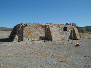
Then the overhead photos:


|
|
|
David K
Honored Nomad
Posts: 65549
Registered: 8-30-2002
Location: San Diego County
Member Is Offline
Mood: Have Baja Fever
|
|
>>> edit, the images you just posted (above)... the last one is at El Volcan, the onyx dome/ geyser... and there are big pools of water on
both sides of it.
elbeau, there are a LOT of minerals there in addition to the huge lime deposit (onyx, marble, limestone) that goes for a dozen miles.
Where that deposit is exposed by erosion of the newer volcanic overlay, then the white rock/stain can be seen (in dozens of places) at the source and
deposited downstream during rains.
The other odd shapes are mostly lava flows where they have been cut through by arroyos/ gullies. Then there are some really big elephant trees and
cardons in there, too.
I hope you can find a way to come to California to see for yourself... but when we get back there through TW's camera, mine, or other's... it should
lay to rest your anxiousness.
While there are mines and mine claims (test holes) all over this region, I don't see them at the Santa Isabel site... They are all reached by road or
very near a road and are obvious on Google Earth.
One of my favorite Baja mine tunnels you can see on Google Earth is the San Juan mine, near the top of the mountain southwest of Las Flores (south of
L.A. Bay). There is an open pit mine northeast of Mision San Borja, serviced by a road heading east, just a couple miles north of San Borja,in the
next valley. This is new since I was in that valley in 2001 looking at a petroglyph site.
[Edited on 4-3-2011 by David K]
|
|
|
elbeau
Nomad
Posts: 256
Registered: 3-2-2011
Location: Austin, TX
Member Is Offline
|
|
| Quote: | Originally posted by woody with a view
elbow, get off the couch and get out there...who are you, and what is your motive? |
Yeah, I know...don't I wish.
If you're terribly interested in who I am, just read the thread, it's been asked and answered over and over...including two days ago.
|
|
|
elbeau
Nomad
Posts: 256
Registered: 3-2-2011
Location: Austin, TX
Member Is Offline
|
|
| Quote: | Originally posted by woody with a view
FWIW, i only see scrub brush, and natural features..... |
Yeah, and you're probably right...but what's the worst that can come of this? We've already produced the best documentation available online for the
area. The worst that happens here is that I'm wrong about all the archaeology and this thread turns into a resource on how NOT to interpret GE
imagery and it becomes a resource for anybody wanting to understand or visit the area and it becomes a resource on the history of this area of Baja.
Those are three VERY appropriate uses of a BajaNomad threas...wouldn't you agree?
And for what it's worth, people may mock dreamers, but I'd rather be a dreamer anyways 
|
|
|
TMW
Select Nomad
Posts: 10659
Registered: 9-1-2003
Location: Bakersfield, CA
Member Is Offline
|
|
elbeau you really should find a way to join us in the exploration of the site. It will put your mind at rest once and for all. Woody should join us
too. If we find something good, if not we have at least answered many questions. I also hope DK can join us. This time my brother Bill will be with
me, not the same Bill as before, and we are both retired and can spend as much time as necessary to satisfy our imaginations. Beside I would like to
open the road to La Olividada if the washout isn't too bad.
|
|
|
elbeau
Nomad
Posts: 256
Registered: 3-2-2011
Location: Austin, TX
Member Is Offline
|
|
| Quote: | Originally posted by TW
elbeau you really should find a way to join us in the exploration of the site. It will put your mind at rest once and for all. Woody should join us
too. If we find something good, if not we have at least answered many questions. I also hope DK can join us. This time my brother Bill will be with
me, not the same Bill as before, and we are both retired and can spend as much time as necessary to satisfy our imaginations. Beside I would like to
open the road to La Olividada if the washout isn't too bad. |
Yeah, I've promoted this to a point that it's ridiculous if I don't come, but I really doubt I can. I've talked this thread to death at this point,
and I'll continue to post stuff if it adds to what we know of the area, but I've got to admit that doing little more than debating the same points
with different people on this thread each week is getting a little old and obsessive-looking. Let's just see what turns up and whenever I can get
things together for a trip I'll come to the site myself even if the debate is already laid to rest before then. I've caught a little of the "Baja bug"
and I'm sure I'll make it down there before too long.
|
|
|
David K
Honored Nomad
Posts: 65549
Registered: 8-30-2002
Location: San Diego County
Member Is Offline
Mood: Have Baja Fever
|
|
| Quote: | Originally posted by TW
elbeau you really should find a way to join us in the exploration of the site. It will put your mind at rest once and for all. Woody should join us
too. If we find something good, if not we have at least answered many questions. I also hope DK can join us. This time my brother Bill will be with
me, not the same Bill as before, and we are both retired and can spend as much time as necessary to satisfy our imaginations. Beside I would like to
open the road to La Olividada if the washout isn't too bad. |
Do you have a firm date for the El Volcan expedition Tom?
|
|
|
David K
Honored Nomad
Posts: 65549
Registered: 8-30-2002
Location: San Diego County
Member Is Offline
Mood: Have Baja Fever
|
|
| Quote: | Originally posted by elbeau
| Quote: | Originally posted by TW
elbeau you really should find a way to join us in the exploration of the site. It will put your mind at rest once and for all. Woody should join us
too. If we find something good, if not we have at least answered many questions. I also hope DK can join us. This time my brother Bill will be with
me, not the same Bill as before, and we are both retired and can spend as much time as necessary to satisfy our imaginations. Beside I would like to
open the road to La Olividada if the washout isn't too bad. |
Yeah, I've promoted this to a point that it's ridiculous if I don't come, but I really doubt I can. I've talked this thread to death at this point,
and I'll continue to post stuff if it adds to what we know of the area, but I've got to admit that doing little more than debating the same points
with different people on this thread each week is getting a little old and obsessive-looking. Let's just see what turns up and whenever I can get
things together for a trip I'll come to the site myself even if the debate is already laid to rest before then. I've caught a little of the "Baja bug"
and I'm sure I'll make it down there before too long. |
It's okay with me (and many more) to keep right on with this fun stuff, IMO. If anybody doesn't like it, they can read other threads, afterall.
I would far rather come to Nomad to read about a Baja lost mission, or an adventure, or just look at some satellite images and wonder a bit, then most
anything else.. this is fun!
|
|
|
TMW
Select Nomad
Posts: 10659
Registered: 9-1-2003
Location: Bakersfield, CA
Member Is Offline
|
|
David it looks like Friday April 29 to the wash and camp over night then get an early start Saturday morning.
I'm working around Ken Cooke and his Jeep group. They will be at Gonzaga Bay on Monday the 25th, then meet me at the Turquesa Mine on Tuesday the 26th
to do the mine run. Then they are going to LA Bay. They will be at Catavina on the 28th to run into Mission Santa Maria. Bajacat and I will join them.
We will come out on the 29th and Bajacat and I are heading to El Marmol and the wash. I've asked Ken to join us too but I don't know if his schedule
will allow it. I also suggested he might skip the mine run and hit LA Bay a day early and the mission a day early and then join us at the wash to
explore. That would mean getting to the wash on Thursday the 28th a day earlier. Not sure how that might affect Bajacat.
We'll work it all out somehow.
|
|
|
bryanmckenzie
Senior Nomad
Posts: 561
Registered: 9-23-2009
Location: 400 Km from Mexico Beach, Florida
Member Is Offline
Mood: Hot & humid --- not hot & dry.
|
|
"...nobody has responded and the GE BBS post has been relegated to the forum containing mostly alien conspiracies. It was YOUR suggestion, and I
quickly saw the value it could offer and followed through...is there something I'm missing here?"
Yes. Several things.
(1) Take out the words "lost civilization." Even with that you had 96 views, 0 responses, because ...
(2) You didn't attach the KML at GE BBS. You're asking people to change to another forum, then have to find the KML of page 3 which is daunting.
(3) Which forum did you post to originally? Do you know which moderator moved it? I know many of them and can maybe have it moved to the unmoderated
PEOPLE & CULTURES or HISTORY forum.
|
|
|
| Pages:
1
..
12
13
14
15
16
..
23 |


