| Pages:
1
2
3
4
..
6 |
cupcake
Senior Nomad

Posts: 847
Registered: 4-23-2024
Member Is Offline
|
|
Quote: Originally posted by David K  | | Quote: Originally posted by cupcake | Thanks PaulW.
I just downloaded the Garmin 22X Owner's Manual, and I will be reading through it as I familiarize myself with the device.
The critical thing for me, was to be able to take a GPS reading of locations along the way, and this seems easy enough to do. I was pleasantly
surprised to see that each GPS location reading, or waypoint, that my device takes, also has an elevation in feet. I wasn't expecting that, as I was
told that this model has no altimeter. Maybe the device calculates elevation in a different manner? In any even, the elevations it has given thus far
have been accurate. |
Yes, it uses the distance to the satellites and the distance from them to sea level to calculate your elevation. It is pretty accurate and no need for
barametic pressure adjustment. |
Thanks David. I was at REI today and was advised of the same. Apparently, this 22X device uses a multi-band system, which makes it more reliable in
canyons, or other areas where high, sheer, rock formations can render a single-band system unit less reliable. This is discussed at a Garmin website:
https://www.garmin.com/en-US/blog/outdoor/why-multi-band-qa-...
|
|
|
David K
Honored Nomad
Posts: 65581
Registered: 8-30-2002
Location: San Diego County
Member Is Offline
Mood: Have Baja Fever
|
|
I have owned two Garmin eTrex models and recorded many waypoints when I was traveling in the early 2000s. They are all on this webpage at VivaBaja.com
and now I have included the GPX file (and a KMZ link) should you wish to download them: https://vivabaja.com/gps/
|
|
|
cupcake
Senior Nomad
Posts: 847
Registered: 4-23-2024
Member Is Offline
|
|
| Quote: Originally posted by 4x4abc | | Quote: Originally posted by PaulW | Cupcake
Using a Garmin etrex 22x:
you can import a GPX file to a Garmin eTrex 22x by transferring the file to the device's GPX folder
How to get a gpx file
1) Have some one send you the file
2) Make your own file
a) Go to Google Earth and use “add a path” and make the track
b) The save the file as a kml file
c) Go to the web and convert it to a gpx file
d) follow instructions on the first line above.
Many trails and roads are clearly visible on Google Earth for you to make a path from.
Once you make the path it will contain all the track points on your gps you want. |
I'll be happy to provide the entire track
plus whatever waypoints you like
I hate Garmin products, but now you are stuck with it
I would highly recommend to spend as much time as possible on Google Earth (desktop version) and follow the trail.
There are long sections where the trail has been washed away. Since those sections often are not used by locals or animals - there is no path to
follow. It will be bushwhacking until you pick up the established trail again.
I would highly recommend to mark those points where the trail disappears and comes back up again. Otherwise you might be bushwhacking parallel to the
trail unnecessarily.
I'll be happy to mark those in/out points for you.
Then you transfer them into your GPS.
They won't do you any good on the paper map.
I have done this section with locals guides.
It is fun and relatively easy.
But you could also get lost at a heartbeat.
if you do the trail alone - get an inReach device. The cheapest one will do.
[Edited on 10-20-2024 by 4x4abc] |
Thanks Harald.
Yes, please pass along this information. I might not get up to speed to use it properly, but I should at least give it a shot.
Thanks also for your words of wisdom!
There is a good chance I will try to go with a guide or vaquero. The thought of not having to carry all my water, food, and gear is rather appealing.
[Edited on 10-22-2024 by cupcake]
|
|
|
cupcake
Senior Nomad
Posts: 847
Registered: 4-23-2024
Member Is Offline
|
|
| Quote: Originally posted by David K | I have owned two Garmin eTrex models and recorded many waypoints when I was traveling in the early 2000s. They are all on this webpage at VivaBaja.com
and now I have included the GPX file (and a KMZ link) should you wish to download them: https://vivabaja.com/gps/
|
Thanks David.
I will certainly have a look at your linked information. As with everyone, I am limited by what I can get my head around.
|
|
|
David K
Honored Nomad
Posts: 65581
Registered: 8-30-2002
Location: San Diego County
Member Is Offline
Mood: Have Baja Fever
|
|
Oh, I get it! "So much Baja... so little time!"
|
|
|
4x4abc
Ultra Nomad
Posts: 4456
Registered: 4-24-2009
Location: La Paz, BCS
Member Is Offline
Mood: happy - always
|
|
Kevin, help me understand your waypoints
almost all are way off the trail
Harald Pietschmann
|
|
|
PaulW
Ultra Nomad
Posts: 3113
Registered: 5-21-2013
Member Is Offline
|
|
Some GPS info
Now days Garmin is using a modern GPS module with 12 channels
This is good because you will have the accuracy that will accurately translate to topo maps.
The Etrex does not create tracks with track points but will create all the waypoints you want and you travel along.
Since you want to travel the ECR you must have a GPX track loaded into your Trex. The reason for this is if all you have are waypoints loaded then you
will surely get immediately get lost. Even with a loaded GPX track if the creator of the track did no use accurate track points. it will still be an
issue.
When I get a track from someone I always view it on an internet viewer to see how far the track points are for each other.
Example a track created by an Inreach can be as accurate a a 5 second track point interval. My Lowrance can also be that accurate. It even has the
option of distance between track points which is what I use and the result is a much bigger file.
One other note about GPS elevation. Accuracy is highly dependent on how many satellites are viewed by the GPS. Thus in a canyon with steep walls (like
Diablo ) the accuracy is very bad. And even the coordinates are inaccurate and will not match the topo map.
|
|
|
cupcake
Senior Nomad
Posts: 847
Registered: 4-23-2024
Member Is Offline
|
|
Harald, You cared enough to check, thank you. I just spot checked a few of my map waypoints and found they are as I intended. I used the Caltopo
website:
https://caltopo.com/map.html#ll=28.03475,-113.11094&z=14...
I was not too concerned about having my waypoints right on the ECR, and being off by 500 feet or so was ok with me; just being near enough to use for
navigation was what I wanted. When you say they are "way off" what kind of distances are you meaning?
My approach to this, because of the nature of my experience, is that my reading of the topo map and the actual terrain when I am on the ground, is the
most important, then compass direction, then GPS coordinates. So, for instance, if I think I see where I am on the map (the surrounding ground
features match my map), and direction of travel looks right (compass), and then the given GPS waypoint on my map is within 500 feet of what my GPS
device reads on the ground, then I am satisfied that this is my location, or nearly so. I would make any corrections to my GPS map waypoints in the
field, as I move.
Now, if you were to tell me that my waypoints are off by a mile, then that would alarm me.
I have no history of using GPS for navigation, so perhaps I will become more concerned with pinpoint GPS accuracy as I work with the technology.
|
|
|
cupcake
Senior Nomad
Posts: 847
Registered: 4-23-2024
Member Is Offline
|
|
David, I have no doubt that I can become competent in using my GPS device, but the question is how quickly can I do that. I suspect not before I go on
my first trip with the device. When I am out on the trail and tired, I don't want to be trying to use something that I am not rock solid with for
navigation. The consequences of failure are too serious. I need to be doing things that I have done for years, that are instinctive to me. I feel
confident I can take accurate GPS readings along the way, as I am doing that easily now. But beyond that, I will see what I can do.
|
|
|
4x4abc
Ultra Nomad
Posts: 4456
Registered: 4-24-2009
Location: La Paz, BCS
Member Is Offline
Mood: happy - always
|
|
| Quote: Originally posted by cupcake |
Harald, You cared enough to check, thank you. I just spot checked a few of my map waypoints and found they are as I intended. I used the Caltopo
website:
https://caltopo.com/map.html#ll=28.03475,-113.11094&z=14...
I was not too concerned about having my waypoints right on the ECR, and being off by 500 feet or so was ok with me; just being near enough to use for
navigation was what I wanted. When you say they are "way off" what kind of distances are you meaning?
My approach to this, because of the nature of my experience, is that my reading of the topo map and the actual terrain when I am on the ground, is the
most important, then compass direction, then GPS coordinates. So, for instance, if I think I see where I am on the map (the surrounding ground
features match my map), and direction of travel looks right (compass), and then the given GPS waypoint on my map is within 500 feet of what my GPS
device reads on the ground, then I am satisfied that this is my location, or nearly so. I would make any corrections to my GPS map waypoints in the
field, as I move.
Now, if you were to tell me that my waypoints are off by a mile, then that would alarm me.
I have no history of using GPS for navigation, so perhaps I will become more concerned with pinpoint GPS accuracy as I work with the technology.
|
only one of the waypoints was on the trail.
You WILL get lost if the waypoints are not on the trail
even though this is an easy section of the trail - it is not that easy
28.04123, -113.10245 260ft off
28.00683, -113.13309 380ft off
27.97242, -113.13892 350ft off
27.93876, -113.12124 340ft off
27.91161, -113.12450 on trail
27.89507, -113.04159 488ft off
27.83437, -113.02683 on trail
27.82875, -113.00486 225ft off
27.81281, -112.97238 640ft off
27.80947, -112.96108 100ft off
starting at 27.745832°, -112.902059° you'll be on a real, recent road until Santa Marta - so no danger there.
[Edited on 10-20-2024 by 4x4abc]
Harald Pietschmann
|
|
|
cupcake
Senior Nomad
Posts: 847
Registered: 4-23-2024
Member Is Offline
|
|
| Quote: Originally posted by PaulW | Some GPS info
Now days Garmin is using a modern GPS module with 12 channels
This is good because you will have the accuracy that will accurately translate to topo maps.
The Etrex does not create tracks with track points but will create all the waypoints you want and you travel along.
Since you want to travel the ECR you must have a GPX track loaded into your Trex. The reason for this is if all you have are waypoints loaded then you
will surely get immediately get lost. Even with a loaded GPX track if the creator of the track did no use accurate track points. it will still be an
issue.
When I get a track from someone I always view it on an internet viewer to see how far the track points are for each other.
Example a track created by an Inreach can be as accurate a a 5 second track point interval. My Lowrance can also be that accurate. It even has the
option of distance between track points which is what I use and the result is a much bigger file.
One other note about GPS elevation. Accuracy is highly dependent on how many satellites are viewed by the GPS. Thus in a canyon with steep walls (like
Diablo ) the accuracy is very bad. And even the coordinates are inaccurate and will not match the topo map. |
Thanks Paul. I downloaded my device owner's manual yesterday and see that it discusses loading files to the device. I'm not sure if I will need to
install a memory card for this, or if there is space for such a file as the device comes from the manufacturer. I guess I will find out when I get
around to connecting the device to a computer.
[Edited on 10-20-2024 by cupcake]
|
|
|
4x4abc
Ultra Nomad
Posts: 4456
Registered: 4-24-2009
Location: La Paz, BCS
Member Is Offline
Mood: happy - always
|
|
for safest travel, you want to be ON the trail!
any bushwhacking will add exhausting hours to your travel
read fatboy's struggle to find his way!
Harald Pietschmann
|
|
|
cupcake
Senior Nomad
Posts: 847
Registered: 4-23-2024
Member Is Offline
|
|
| Quote: Originally posted by 4x4abc | for safest travel, you want to be ON the trail!
any bushwhacking will add exhausting hours to your travel
read fatboy's struggle to find his way! |
Are there not points where possibly the exact trail is overgrown with thorny plants, and by moving off the trail you might have an easier go of it?
I imagine a possible scenario where a hiker might wander back and forth across an old and not much used trail, picking the easiest way, but not losing
'contact' with the original route.
|
|
|
cupcake
Senior Nomad
Posts: 847
Registered: 4-23-2024
Member Is Offline
|
|
| Quote: Originally posted by 4x4abc | | Quote: Originally posted by cupcake |
Harald, You cared enough to check, thank you. I just spot checked a few of my map waypoints and found they are as I intended. I used the Caltopo
website:
https://caltopo.com/map.html#ll=28.03475,-113.11094&z=14...
I was not too concerned about having my waypoints right on the ECR, and being off by 500 feet or so was ok with me; just being near enough to use for
navigation was what I wanted. When you say they are "way off" what kind of distances are you meaning?
My approach to this, because of the nature of my experience, is that my reading of the topo map and the actual terrain when I am on the ground, is the
most important, then compass direction, then GPS coordinates. So, for instance, if I think I see where I am on the map (the surrounding ground
features match my map), and direction of travel looks right (compass), and then the given GPS waypoint on my map is within 500 feet of what my GPS
device reads on the ground, then I am satisfied that this is my location, or nearly so. I would make any corrections to my GPS map waypoints in the
field, as I move.
Now, if you were to tell me that my waypoints are off by a mile, then that would alarm me.
I have no history of using GPS for navigation, so perhaps I will become more concerned with pinpoint GPS accuracy as I work with the technology.
|
only one of the waypoints was on the trail.
You WILL get lost if the waypoints are not on the trail
even though this is an easy section of the trail - it is not that easy
28.04123, -113.10245 260ft off
28.00683, -113.13309 380ft off
27.97242, -113.13892 350ft off
27.93876, -113.12124 340ft off
27.91161, -113.12450 on trail
27.89507, -113.04159 488ft off
27.83437, -113.02683 on trail
27.82875, -113.00486 225ft off
27.81281, -112.97238 640ft off
27.80947, -112.96108 100ft off
starting at 27.745832°, -112.902059° you'll be on a real, recent road until Santa Marta - so no danger there.
[Edited on 10-20-2024 by 4x4abc] |
Thanks for this list of coordinates to verify. I am relieved to see that most are under 500 feet "off trail". I just checked the first coordinate on
this list against the Caltopo website. That coordinate looks to me to be exactly on one of the trails leading out of Mission Santa Gertrudis. There
are a number of trails leading out of Santa Gertrudis (in the area in question), taking any of them will get you on the way to Las Juntas. Now, maybe
that is not the exact ECR that I have marked, I don't know, but I don't see myself getting lost by using that waypoint. That is, as long as the
Caltopo website is accurate. Please do check the Caltopo website...move the mouse cursor to the exact location that I show the waypoint on my topo
map...if you agree that the Caltopo reading for that point is accurate, then I see no problem (with that one waypoint).
[Edited on 10-20-2024 by cupcake]
|
|
|
4x4abc
Ultra Nomad
Posts: 4456
Registered: 4-24-2009
Location: La Paz, BCS
Member Is Offline
Mood: happy - always
|
|
| Quote: Originally posted by cupcake |
Are there not points where possibly the exact trail is overgrown with thorny plants, and by moving off the trail you might have an easier go of it?
I imagine a possible scenario where a hiker might wander back and forth across an old and not much used trail, picking the easiest way, but not losing
'contact' with the original route.
|
ideally you can follow animal tracks on and of the trail for easiest travel
but there are many stretches where animal have no interest in going where you want to go - they might lead you way off.
below is a good example - the well established trail (about 11 ft) has been washed away and all you have is the animal track of about 2.5 ft

Harald Pietschmann
|
|
|
cupcake
Senior Nomad
Posts: 847
Registered: 4-23-2024
Member Is Offline
|
|
| Quote: Originally posted by 4x4abc | | Quote: Originally posted by cupcake |
Are there not points where possibly the exact trail is overgrown with thorny plants, and by moving off the trail you might have an easier go of it?
I imagine a possible scenario where a hiker might wander back and forth across an old and not much used trail, picking the easiest way, but not losing
'contact' with the original route.
|
ideally you can follow animal tracks on and of the trail for easiest travel
but there are many stretches where animal have no interest in going where you want to go - they might lead you way off.
below is a good example - the well established trail (about 11 ft) has been washed away and all you have is the animal track of about 2.5 ft
|
If you know the direction of travel you want (compass), an animal track should not lead you astray. If an animal track starts to deviate from your
desired direction of travel, you should know it pretty quick. I carry a small directional compass on a necklace, so I can spot check my direction of
travel as often as I like.
My approach to this is that I should be ready to reach my desired destinations along the ECR route by what at times might amount to cross country
travel. Being off trail by 250 feet doesn't seem like a problem, as long as I know where I am.
[Edited on 10-20-2024 by cupcake]
|
|
|
David K
Honored Nomad
Posts: 65581
Registered: 8-30-2002
Location: San Diego County
Member Is Offline
Mood: Have Baja Fever
|
|
So much fun living vicariously with your hike!
Thank you.
OK, so now some ECR chat:
I presume you read Harry Crosby's details on the ECR... Road Building in Antigua California: https://sandiegohistory.org/journal/1977/january/bajaroad/
and Mapping ECR: https://sandiegohistory.org/journal/1977/january/bajamapping...
That all was over 50 years ago when researched and later written. Modern ECR mapping hikers (who endevour to locate true Jesuit routes vs more modern
ranch and cattle trails) are Kevin and Genevieve of www.CaminoRealBaja.com
Kevin is very easy to communicate with and open-minded to new discoveries. They began this project over 20 years ago, hiking and mapping sections
during their holidays.
One note from their site:
Many waypoints have a lowercase letter next to the section letter (i.e., Fd58*). The second letter indicates that this is actually a trail option that
is true ECR. There are many of these, and it is good to remember that El Camino Real is really a web of trails that usually converge at the
various missions.
Personal note:
Sadly, I have only hiked a few small sections of the trail... But, between those in-field experinces and reading so much about it, the trail takes the
most logical and easiest route. Obviously, it went to water souces between the missions, as well. The Natives (no doubt) guided the padres and may
have had trails already. However, the Jesuit mission trail (as far as Santa María) was constructed as straight as possible to shorten travel times
and switchbacks were built when the terrain was steep, with straight runs as much as the land would allow.
So, as you run out of visible trail (due to brush growth or flash flood/ erosion) try to just take the most logical route the terrain allows, going
the direction intended. The trail will magically reappear and you will wonder why the missing sections did not show. Well, it has been 300 years or
more for the part south of San Ignacio and well over 200 years for the rest!
Because the Jesuits were removed just a few years after the founding of San Borja, most of the typical Jesuit road/trail ends there and beyond was not
much more than what loks like a cattle trail today. There are some exceptions, but the Franciscans and Dominicans were not the engineers that the
Jesuits were.
When hiking the trail west of Gonzaga Bay, if we lost signs of it, by looking uphill and westbound, we found it again a short distance away.
Now, thanks to the Benchmark Maps digital download, which shows Kevin & Genevieve's track of ECR (Loreto to El Rosario), you can see your position
relative to their track. Now, the scale is not so grand that you can always be precise with their track, at least you will soon see if you are headed
the wrong way. The digital map loads onto a smart phone or tablet, using GPS and not cell towers to locate you anywhere in Baja... and is under $20.
The Avenza Map App you use for it is free: https://store.avenza.com/products/baja-california-atlas-land...
Here is a screenshot of the Benchmark map, on my phone, with the ECR Trail. The bullseye is over the auto road to Mission Santa María. You can save
your tracks, as you see the ones I made here, on the two routes (going and coming) to compare.
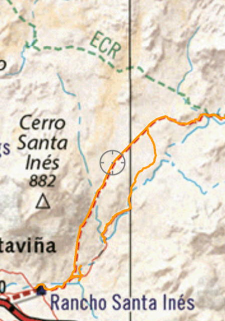
You can't beat this kind of assistance for the price and simplicity.
GOOD LUCK!
|
|
|
cupcake
Senior Nomad
Posts: 847
Registered: 4-23-2024
Member Is Offline
|
|
From David's post above^^
"So, as you run out of visible trail (due to brush growth or flash flood/ erosion) try to just take the most logical route the terrain allows, going
the direction intended. The trail will magically reappear and you will wonder why the missing sections did not show. Well, it has been 300 years or
more for the part south of San Ignacio and well over 200 years for the rest!"
Yes, that is how I envision it (haven't been there yet). If I do this as a solo trekker, I will be on a 'water clock'. I would take three one-gallon
jugs, and I would know where I want to be at given points of my water supply being depleted. Also, very important to be able to 'go back' (i.e. there
are good water sources at Santa Gertrudis and Las Juntas). If I am not going according to 'water schedule', it means what I am doing is not working
and I need to go back.
[Edited on 10-20-2024 by cupcake]
|
|
|
David K
Honored Nomad
Posts: 65581
Registered: 8-30-2002
Location: San Diego County
Member Is Offline
Mood: Have Baja Fever
|
|
Yes, I hope Fatboy chimes in, too!
|
|
|
cupcake
Senior Nomad
Posts: 847
Registered: 4-23-2024
Member Is Offline
|
|
Harald,
I can see the logic in having the waypoints exactly on the trail, so I am changing my waypoints. It is not difficult or time consuming, but I am
limited in the number of free edits I get with the online PDF editors. When I finish, I will send you the PDF sheets and post them here. I will likely
eventually add compass directions as well, but I might do this by hand on the printed maps.
[Edited on 10-21-2024 by cupcake]
|
|
|
| Pages:
1
2
3
4
..
6 |
|


