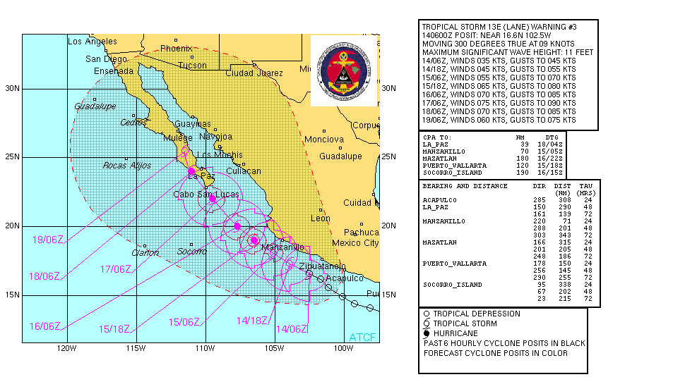
| Pages:
1
2
3
4
..
6 |
bajajudy
Elite Nomad
     
Posts: 6886
Registered: 10-4-2004
Location: San Jose del Cabo,BCS
Member Is Offline
|
|
Can you say.....grab your shorts

So far this one is mild compared to John but who knows what tomorrow will bring

|
|
|
TMW
Select Nomad
      
Posts: 10659
Registered: 9-1-2003
Location: Bakersfield, CA
Member Is Offline
|
|
It only needs to unload rain in the mountains to be bad. Everyone be carefull.
|
|
|
QuePasaBaja
Nomad
 
Posts: 179
Registered: 9-7-2006
Location: Rosarito Beach
Member Is Offline
|
|
Ask the admin to change the title of this thread, I got in here by clicking the wrong wone. I read then name , and thought that you wanted someone by
the name of Lane.
Some may not know the name of the storm yet
Have a Baja Day
QuePasaBaja
|
|
|
ElGato
Junior Nomad

Posts: 36
Registered: 12-23-2005
Location: Santa Cruz, Ca.
Member Is Offline
Mood: Virile
|
|
"LANE" headed for Baja
 New storm Lane headed for Baja. Expected to become hurricane later today or
tomorrow. Projected to hit Los Cabos on Sunday New storm Lane headed for Baja. Expected to become hurricane later today or
tomorrow. Projected to hit Los Cabos on Sunday
Baja Joe  |
|
|
BajaNews
Super Moderator
      
Posts: 1439
Registered: 12-11-2005
Member Is Offline
|
|
TROPICAL STORM LANE INTERMEDIATE ADVISORY NUMBER 4A
NWS TPC/NATIONAL HURRICANE CENTER MIAMI FL EP132006
1100 AM PDT THU SEP 14 2006
...LANE GETTING BETTER ORGANIZED AS IT CONTINUES
WEST-NORTHWESTWARD...
A TROPICAL STORM WARNING AND A HURRICANE WATCH REMAIN IN EFFECT FOR
THE PACIFIC COAST OF MEXICO FROM WEST OF MANZANILLO TO CABO
CORRIENTES. A HURRICANE WATCH MEANS THAT HURRICANE CONDITIONS ARE
POSSIBLE WITHIN THE WATCH AREA...GENERALLY WITHIN 36 HOURS.
A TROPICAL STORM WARNING REMAINS IN EFFECT FOR THE PACIFIC COAST OF
MEXICO FROM TECPAN DE GALEANA TO MANZANILLO. A TROPICAL STORM
WARNING MEANS THAT TROPICAL STORM CONDITIONS ARE EXPECTED WITHIN
THE WARNING AREA WITHIN THE NEXT 24 HOURS.
INTERESTS IN SOUTHERN BAJA CALIFORNIA AND ELSEWHERE ALONG THE COAST
OF NORTHWESTERN MEXICO SHOULD MONITOR THE PROGRESS OF LANE.
FOR STORM INFORMATION SPECIFIC TO YOUR AREA...INCLUDING POSSIBLE
INLAND WATCHES AND WARNINGS...PLEASE MONITOR PRODUCTS ISSUED
BY YOUR LOCAL WEATHER OFFICE.
AT 1100 AM PDT...1800Z...THE CENTER OF TROPICAL STORM LANE WAS
LOCATED NEAR LATITUDE 17.8 NORTH...LONGITUDE 104.8 WEST OR ABOUT 95
MILES...150 KM...SOUTH OF MANZANILLO MEXICO AND ABOUT 485 MILES...
780 KM...SOUTHEAST OF CABO SAN LUCAS MEXICO.
LANE IS MOVING TOWARD THE WEST-NORTHWEST NEAR 13 MPH...20 KM/HR. A
GRADUAL TURN TOWARD THE NORTHWEST AT A SLOWER FORWARD SPEED IS
EXPECTED DURING THE NEXT 24 HOURS. THIS MOTION SHOULD KEEP THE
CENTER OF LANE OFFSHORE OF THE WESTERN COAST OF MEXICO TODAY AND
TONIGHT. HOWEVER...TROPICAL STORM CONDITIONS WILL CONTINUE TO
SPREAD ACROSS THE WARNING AREA TODAY.
MAXIMUM SUSTAINED WINDS ARE NEAR 45 MPH...75 KM/HR...WITH HIGHER
GUSTS. STRENGTHENING IS FORECAST DURING THE NEXT 24 HOURS...AND
LAND COULD BECOME A HURRICANE ON FRIDAY.
TROPICAL STORM FORCE WINDS EXTEND OUTWARD UP TO 140 MILES...220 KM
FROM THE CENTER.
ESTIMATED MINIMUM CENTRAL PRESSURE IS 999 MB...29.50 INCHES.
TOTAL RAINFALL ACCUMULATIONS OF 3 TO 6 INCHES ARE EXPECTED ALONG THE
WEST-CENTRAL COAST OF MEXICO...WITH ISOLATED MAXIMUM RAINFALL
AMOUNTS OF 10 INCHES POSSIBLE OVER THE COASTAL MOUNTAINS. THESE
RAINS COULD CAUSE LIFE-THREATENING FLASH FLOODS AND MUDSLIDES.
REPEATING THE 1100 AM PDT POSITION...17.8 N...104.8 W. MOVEMENT
TOWARD...WEST-NORTHWEST NEAR 13 MPH. MAXIMUM SUSTAINED WINDS...45
MPH. MINIMUM CENTRAL PRESSURE...999 MB.
|
|
|
BajaNews
Super Moderator
      
Posts: 1439
Registered: 12-11-2005
Member Is Offline
|
|
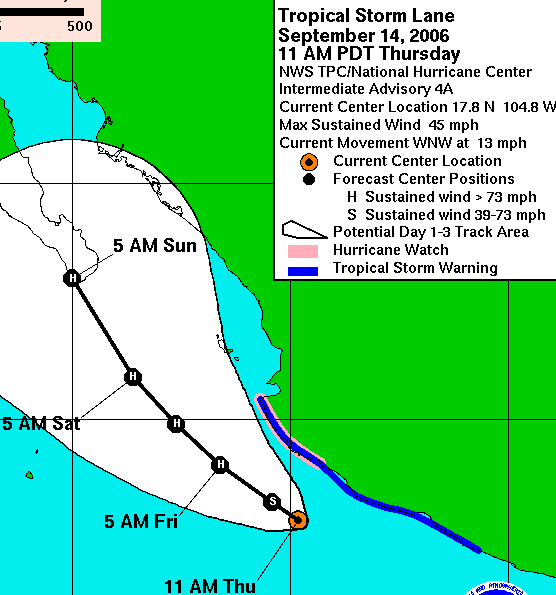
As of 11am Thursday:

|
|
|
cat127
Junior Nomad

Posts: 50
Registered: 7-23-2006
Location: Hawaii
Member Is Offline
|
|
Hey WHY YOU GUYS IN BAJA TAKING ALL OUR STORMS????
Havent had but one little Dibble of storm this whole season cuz they moved up not left.... building boom is slowing down here so send a storm our way!
LOL!
Fate Smiles as Destiny laughs!
|
|
|
Bruce R Leech
Elite Nomad
     
Posts: 6796
Registered: 9-20-2004
Location: Ensenada formerly Mulege
Member Is Offline
Mood: A lot cooler than Mulege
|
|
| Quote: | Originally posted by cat127
Hey WHY YOU GUYS IN BAJA TAKING ALL OUR STORMS????
Havent had but one little Dibble of storm this whole season cuz they moved up not left.... building boom is slowing down here so send a storm our way!
LOL! |
be careful of what you ask for . 
you can have the rest of the storms this season
Bruce R Leech
Ensenada
 |
|
|
BajaNews
Super Moderator
      
Posts: 1439
Registered: 12-11-2005
Member Is Offline
|
|
Tropical Storm Lane heads toward Baja
http://www.chron.com/disp/story.mpl/ap/world/4186974.html
MEXICO CITY Tropical Storm Lane lashed Mexico's Pacific Coast with winds and rain Thursday, flooding streets in Acapulco before setting on a course
to hit the hurricane-battered tip of the Baja California peninsula...
...Lane dumped rain and whipped up waves in Acapulco, where authorities closed the port to small boats. Streets were covered in up to 16 inches of
water _ including the beachside Costera Miguel Aleman, which runs past many of the resort's luxury hotels.
There was also some flooding at the Acapulco airport, although service was not interrupted.
Forecasters warned up to 10 inches of rain were possible.
The storm was following the same path as Hurricane John, which raked Mexico's Pacific Coast early this month before slamming into Baja California,
killing five people.
|
|
|
Al G
Ultra Nomad
    
Posts: 2647
Registered: 12-19-2004
Location: Todos Santos/Full time for now...
Member Is Offline
Mood: Wondering what is next???
|
|
http://www.wunderground.com/tropical/tracking/ep200613_model...
What a dramatic change from yesterday.
GFDL has is ripping the mainland coast now.
Albert G
Remember, if you haven\'t got a smile on your face and laughter in your heart, then you are just a sour old fart!....
The most precious thing we have is life, yet it has absolutely no trade-in value.
|
|
|
Hook
Elite Nomad
     
Posts: 9011
Registered: 3-13-2004
Location: Sonora
Member Is Offline
Mood: Inquisitive
|
|
| Quote: | Originally posted by BajaNews
http://www.chron.com/disp/story.mpl/ap/world/4186974.html
MEXICO CITY Tropical Storm Lane lashed Mexico's Pacific Coast with winds and rain Thursday, flooding streets in Acapulco before setting on a course
to hit the hurricane-battered tip of the Baja California peninsula...
...Lane dumped rain and whipped up waves in Acapulco, where authorities closed the port to small boats. Streets were covered in up to 16 inches of
water _ including the beachside Costera Miguel Aleman, which runs past many of the resort's luxury hotels.
There was also some flooding at the Acapulco airport, although service was not interrupted.
Forecasters warned up to 10 inches of rain were possible.
The storm was following the same path as Hurricane John, which raked Mexico's Pacific Coast early this month before slamming into Baja California,
killing five people. |
Outside of Mr. Clarke, who and where were the other four confirmed fatalities from John.
|
|
|
DianaT
Select Nomad
      
Posts: 10020
Registered: 12-17-2004
Member Is Offline
|
|
CNN article saying five killed by Hurricane John
Still hoping Lane changes directions and heads west.
[Edited on 9-14-2006 by jdtrotter]
|
|
|
Sharksbaja
Elite Nomad
     
Posts: 5814
Registered: 9-7-2004
Location: Newport, Mulege B.C.S.
Member Is Offline
|
|
note the band of moisture flowing east into the storm.
Looks like Los Cabos will get it this time. Pray for Baja.
13-E Visible loop
DON\'T SQUINT! Give yer eyes a break!
Try holding down [control] key and toggle the [+ and -] keys
Viva Mulege!
Nomads\' Sunsets
|
|
|
Bruce R Leech
Elite Nomad
     
Posts: 6796
Registered: 9-20-2004
Location: Ensenada formerly Mulege
Member Is Offline
Mood: A lot cooler than Mulege
|
|
scary
Bruce R Leech
Ensenada
 |
|
|
BajaNews
Super Moderator
      
Posts: 1439
Registered: 12-11-2005
Member Is Offline
|
|
Infrared Loop - as of 1pm today (Thursday):

|
|
|
Johnny
Junior Nomad

Posts: 36
Registered: 9-4-2006
Location: San Diego
Member Is Offline
Mood: concerned
|
|
Anyone who can get word to the remote areas please do so now.
Below is the 2pm update from nhc.noaa.gov. Viva Baja.
000
WTPZ33 KNHC 142040
TCPEP3
BULLETIN
TROPICAL STORM LANE ADVISORY NUMBER 5
NWS TPC/NATIONAL HURRICANE CENTER MIAMI FL EP132006
200 PM PDT THU SEP 14 2006
...LANE STRENGTHENS...EXPECTED TO BECOME A HURRICANE...
AT 2 PM PDT...2100 UTC...THE GOVERNMENT OF MEXICO HAS ADJUSTED THE
TROPICAL STORM WARNING...WHICH NOW EXTENDS FROM LAZARO Card##AS TO
EL ROBLITO...AND INCLUDES THE ISLAS MARIAS.
AT 2 PM PDT...THE GOVERNMENT OF MEXICO HAS ISSUED A HURRICANE WATCH
FOR THE ISLAS MARIAS. A HURRICANE WATCH REMAINS IN EFFECT FROM
MANZANILLO TO CABO CORREIENTES. A HURRICANE WATCH MEANS THAT
HURRICANE CONDITIONS ARE POSSIBLE WITHIN THE WATCH AREA...GENERALLY
WITHIN 36 HOURS.
INTERESTS IN SOUTHERN BAJA CALIFORNIA AND ELSEWHERE ALONG THE COAST
OF NORTHWESTERN MEXICO SHOULD MONITOR THE PROGRESS OF LANE.
FOR STORM INFORMATION SPECIFIC TO YOUR AREA...INCLUDING POSSIBLE
INLAND WATCHES AND WARNINGS...PLEASE MONITOR PRODUCTS ISSUED
BY YOUR LOCAL WEATHER OFFICE.
AT 200 PM PDT...2100Z...THE CENTER OF TROPICAL STORM LANE WAS
LOCATED NEAR LATITUDE 17.9 NORTH...LONGITUDE 105.2 WEST OR ABOUT 95
MILES...155 KM...SOUTHWEST OF MANZANILLO MEXICO AND ABOUT 460 MILES
...740 KM...SOUTHEAST OF CABO SAN LUCAS MEXICO.
LANE IS MOVING TOWARD THE WEST-NORTHWEST NEAR 14 MPH...22 KM/HR. A
TURN TO THE NORTHWEST WITH A DECREASE IN FORWARD SPEED IS EXPECTED
OVER THE NEXT 24 HOURS. ON THE FORECAST TRACK...THE CENTER OF LANE
WOULD REMAIN OFF THE COAST OF MEXICO TONIGHT. HOWEVER...TROPICAL
STORM CONDITIONS WILL CONTINUE TO AFFECT PORTIONS OF THE WARNING
AREA TONIGHT.
MAXIMUM SUSTAINED WINDS HAVE INCREASED AND ARE NOW NEAR 60 MPH...95
KM/HR...WITH HIGHER GUSTS. ADDITIONAL STRENGTHENING IS EXPECTED AND
LANE IS FORECAST TO REACH HURRICANE STRENGTH DURING THE NEXT 12 TO
24 HOURS.
TROPICAL STORM FORCE WINDS EXTEND OUTWARD UP TO 140 MILES...220 KM
FROM THE CENTER.
ESTIMATED MINIMUM CENTRAL PRESSURE IS 997 MB...29.44 INCHES.
RAINFALL ACCUMULATIONS OF 2 TO 4 INCHES...WITH ISOLATED HIGHER
AMOUNTS OF 5 INCHES OVER THE COASTAL MOUNTAINS...CAN BE EXPECTED IN
ASSOCIATION WITH LANE. THESE RAINS COULD CAUSE LIFE-THREATENING
FLASH FLOODS AND MUD SLIDES.
REPEATING THE 200 PM PDT POSITION...17.9 N...105.2 W. MOVEMENT
TOWARD...WEST-NORTHWEST NEAR 14 MPH. MAXIMUM SUSTAINED WINDS...60
MPH. MINIMUM CENTRAL PRESSURE...997 MB.
AN INTERMEDIATE ADVISORY WILL BE ISSUED BY THE NATIONAL HURRICANE
CENTER AT 500 PM PDT FOLLOWED BY THE NEXT COMPLETE ADVISORY AT 800
PM PDT.
$$
FORECASTER FRANKLIN
|
|
|
BajaNews
Super Moderator
      
Posts: 1439
Registered: 12-11-2005
Member Is Offline
|
|
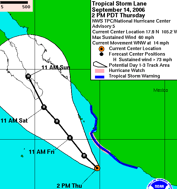
3-day predicted path & wind speed, as of 2pm Thursday:

|
|
|
Bruce R Leech
Elite Nomad
     
Posts: 6796
Registered: 9-20-2004
Location: Ensenada formerly Mulege
Member Is Offline
Mood: A lot cooler than Mulege
|
|
it is starting to look more and more like John allover again
Bruce R Leech
Ensenada
 |
|
|
bajarich
Nomad
 
Posts: 464
Registered: 1-13-2005
Member Is Offline
|
|
It reminds me of Marty comming right on the heals of Ignacio--only worse!
|
|
|
Shimmer
Junior Nomad

Posts: 69
Registered: 11-29-2005
Location: Todos Santo BCS
Member Is Offline
Mood: In the Question
|
|
Here is the latest 8 pm update... Baja Sur in Hurricane Watch
000
WTPZ33 KNHC 150243
TCPEP3
BULLETIN
TROPICAL STORM LANE ADVISORY NUMBER 6
NWS TPC/NATIONAL HURRICANE CENTER MIAMI FL EP132006
800 PM PDT THU SEP 14 2006
...LANE GETTING BETTER ORGANIZED...EXPECTED TO BECOME A HURRICANE...
AT 800 PM PDT...THE GOVERNMENT OF MEXICO HAS ISSUED A HURRICANE
WATCH AND A TROPICAL STORM WARNING ALONG THE COAST OF THE BAJA
CALIFORNIA PENINSULA FROM BUENA VISTA SOUTHWARD ALONG THE EAST
COAST...AND FROM AGUA BLANCA SOUTHWARD ALONG THE WEST COAST. A
HURRICANE WATCH MEANS THAT HURRICANE CONDITIONS ARE POSSIBLE WITHIN
THE WATCH AREA...GENERALLY WITHIN 36 HOURS. A TROPICAL STORM
WARNING MEANS THAT TROPICAL STORM CONDITIONS ARE EXPECTED WITHIN
THE WARNING AREA WITHIN THE NEXT 24 HOURS.
A TROPICAL STORM WARNING IS IN EFFECT FROM LAZARO Card##AS NORTHWARD
TO EL ROBLITO...INCLUDING THE ISLAS MARIAS.
A HURRICANE WATCH REMAINS IN EFFECT FOR THE ISLAS MARIAS. A
HURRICANE WATCH IS ALSO REMAINS IN EFFECT FROM MANZANILLO NORTHWARD
TO CABO CORRIENTES.
INTERESTS IN SOUTHERN BAJA CALIFORNIA AND ELSEWHERE ALONG THE COAST
OF NORTHWESTERN MEXICO SHOULD MONITOR THE PROGRESS OF LANE.
FOR STORM INFORMATION SPECIFIC TO YOUR AREA...INCLUDING POSSIBLE
INLAND WATCHES AND WARNINGS...PLEASE MONITOR PRODUCTS ISSUED
BY YOUR LOCAL WEATHER OFFICE.
AT 800 PM PDT...0300Z...THE CENTER OF TROPICAL STORM LANE WAS
LOCATED NEAR LATITUDE 18.4 NORTH...LONGITUDE 105.3 WEST OR ABOUT 75
MILES...125 KM...WEST-SOUTHWEST OF MANZANILLO MEXICO AND ABOUT 430
MILES...690 KM...SOUTHEAST OF CABO SAN LUCAS MEXICO.
LANE IS MOVING TOWARD THE NORTHWEST NEAR 6 MPH...9 KM/HR. A
TURN TO THE NORTHWEST WITH A DECREASE IN FORWARD SPEED IS EXPECTED
OVER THE NEXT 24 HOURS. ON THE FORECAST TRACK...THE CENTER OF LANE
WOULD REMAIN OFF THE COAST OF MEXICO TONIGHT. HOWEVER...TROPICAL
STORM CONDITIONS WILL CONTINUE TO AFFECT PORTIONS OF THE WARNING
AREA TONIGHT.
MAXIMUM SUSTAINED WINDS ARE NEAR 60 MPH...95 KM/HR...WITH HIGHER
GUSTS. ADDITIONAL STRENGTHENING IS EXPECTED AND LANE IS FORECAST TO
REACH HURRICANE STRENGTH DURING THE NEXT 12 TO 24 HOURS.
TROPICAL STORM FORCE WINDS EXTEND OUTWARD UP TO 140 MILES...220 KM
FROM THE CENTER.
ESTIMATED MINIMUM CENTRAL PRESSURE IS 997 MB...29.44 INCHES.
TOTAL RAINFALL ACCUMULATIONS OF 2 TO 4 INCHES ARE EXPECTED ALONG THE
WEST CENTRAL COAST OF MEXICO...WITH ISOLATED MAXIMUM AMOUNTS OF 6
INCHES POSSIBLE OVER THE COASTAL MOUNTAINS. THIS RAINFALL COULD
CAUSE LIFE-THREATENING FLASH FLOODS AND MUDSLIDES.
REPEATING THE 800 PM PDT POSITION...18.4 N...105.3 W. MOVEMENT
TOWARD...NORTHWEST NEAR 6 MPH. MAXIMUM SUSTAINED WINDS...60 MPH.
MINIMUM CENTRAL PRESSURE...997 MB.
AN INTERMEDIATE ADVISORY WILL BE ISSUED BY THE NATIONAL HURRICANE
CENTER AT 1100 PM PDT FOLLOWED BY THE NEXT COMPLETE ADVISORY AT 200
AM PDT.
$$
|
|
|
| Pages:
1
2
3
4
..
6 |

