| Pages:
1
2 |
Barry A.
Select Nomad
      
Posts: 10007
Registered: 11-30-2003
Location: Redding, Northern CA
Member Is Offline
Mood: optimistic
|
|
David------are we sure that is the "road" that E.S.Gardner and crew took???? or is it just assumed???? I sorta got the impression that they were
just winging it, making "roads" as they went. (??)
-------in other words----did that "old" road really exist in the ' 60's AS IS SHOWN on the Almanac map?
(what a great mystery to be solved-----finding those "walls" in the old photos. )
Barry
|
|
|
David K
Honored Nomad
        
Posts: 65437
Registered: 8-30-2002
Location: San Diego County
Member Is Offline
Mood: Have Baja Fever
|
|
Yup... I have seen the photos and been to the same places... It is real cool to be in the same spot as great ones before you! Probably why I love the
El Camino Real so much... Just to walk in the same place as the great ones of the past!
The Feb., 1966 Gardner convey went to LAS FLORES, LAS ANIMAS, THE MYSTERY WALL ('Lost Mission' Site), EL BARRIL.
There are photos in Off the Beaten Track in Baja of a difficult arroyo crossing that took the team quite a while to open up... That spot is Arroyo El
Alambrado crossing, east of Valle la Bocana.
There was some auto track, but not on a map in '66 to Los Paredones (Jesus Flores' ranch) and on south to La Bocana (misnamed San Pedro in the
Almanac)... From La Bocana east, they searched for both the Gulfo Camino Real or an old mine prospect road coming into the area from El Barril or El
Arco.
I can see the old Camino Real or ? right by the current road, just east of La Bocana on Google Earth/ Wikimapia.org...
Great fun!
|
|
|
David K
Honored Nomad
        
Posts: 65437
Registered: 8-30-2002
Location: San Diego County
Member Is Offline
Mood: Have Baja Fever
|
|
Here's where the Gulfo Camino Real nears the current road, just a couple miles east of La Bocana (San Pedro)... north on top:
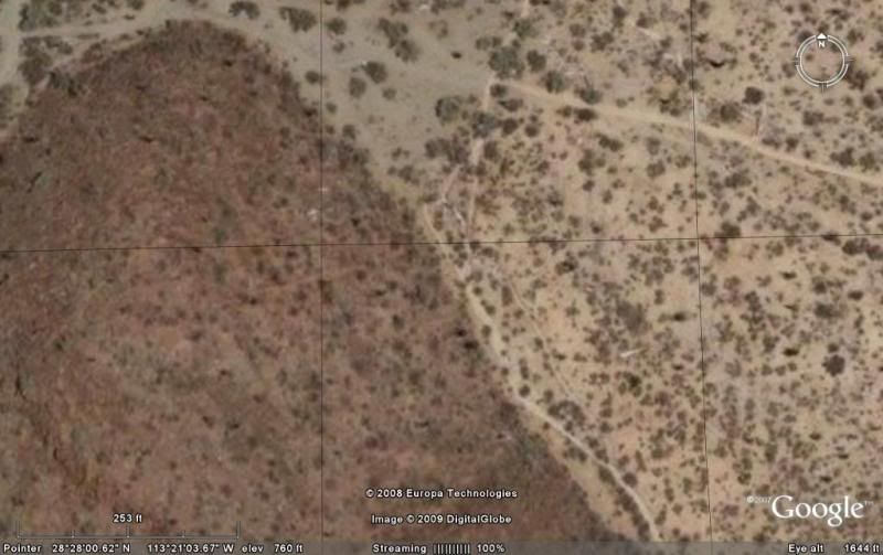
The auto road is going from left to right along the top and tha Camino Real is coming in along the side of that hill heading north-west. You can see
typical Camino Real road sign of parallel lines of rocks on each side of the trail. This point is easy to find as the auto road touches the base of
that hill, only here.
[Edited on 12-22-2008 by David K]
|
|
|
David K
Honored Nomad
        
Posts: 65437
Registered: 8-30-2002
Location: San Diego County
Member Is Offline
Mood: Have Baja Fever
|
|
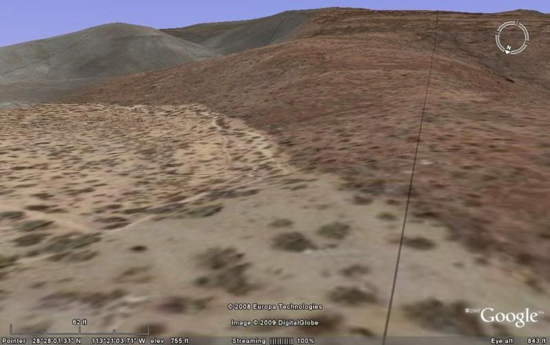
Here is looking southeast, at an angle, right down the Camino Real, along the base of that hill... the auto road is at the bottom of the image...
|
|
|
David K
Honored Nomad
        
Posts: 65437
Registered: 8-30-2002
Location: San Diego County
Member Is Offline
Mood: Have Baja Fever
|
|
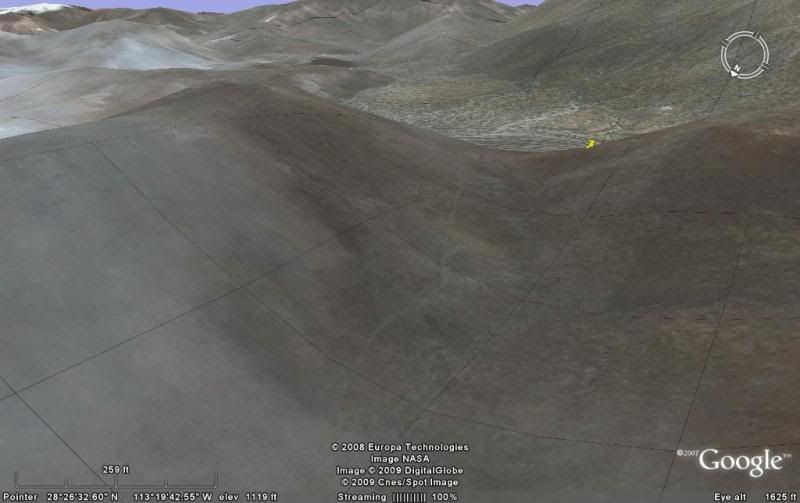
A bit further south of the old trail, where it climbs a low ridge and then drops into the arroyo that contains the tinaja of Santa Maria... that we
visited on search #1 and #3...
|
|
|
Barry A.
Select Nomad
      
Posts: 10007
Registered: 11-30-2003
Location: Redding, Northern CA
Member Is Offline
Mood: optimistic
|
|
Oh wow------that is incredible! You can actually see the trail going over that volcanic (?) hill---------it is amazing what this new technology
reveals--------I now see what you mean when you say, "we will find the "site" soon". I would like to go down there and just poke around until I find
it-----I have the time. (my wife might not care for the idea, tho) 
Seems to me that just tracking/hiking the historic Camino from south to north in this area you would eventually find the site-----who knows what else
you would find. Do you know if anybody has done this?
Barry
|
|
|
David K
Honored Nomad
        
Posts: 65437
Registered: 8-30-2002
Location: San Diego County
Member Is Offline
Mood: Have Baja Fever
|
|
Harry Crosby on the Camino Real used by Serra... not sure if he also traversed the Gulfo Camino (east branch) shown here... Arthur North did around
1905 for his 'Camp and Camino in Lower California'... He even mentions the Tinaja de Santa Maria.
Here is Harry's map of the El Camino Real routes between Santa Gertrudis and San Borja... note on the east branch 'Santa Maria' and 'La Bocana'...

parallel solid (west branch) or dashed (east branch) lines indicate visual Jesuit road constrution. The single solid or dashed lines indicate approx.
route.
[Edited on 12-22-2008 by David K]
|
|
|
David K
Honored Nomad
        
Posts: 65437
Registered: 8-30-2002
Location: San Diego County
Member Is Offline
Mood: Have Baja Fever
|
|
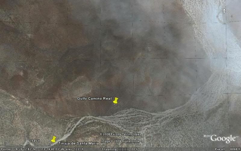
TINAJA SANTA MARIA
Here is the satellite view from just south of Tinaja Santa Maria, north at top... the other dart is on the trail coming over the hill down to the
arroyo with the tinaja. This is the other side of the hill shown in the above image that Barry replied to.
Next is a photo I took at the tinaja... see my son on his motor bike. The tinaja is in the gravel at the base of the rocks in the background.

The end of the 'road'. This water hole served travelers on the Gulfo Camino between Santa Gertrudis and San Borja. GPS is N28°26.07'/ W113°19.99' (map
datum NAD27). Cerro la Sandia is in the distance. This is the same peak seen south from L.A. Bay.
[Edited on 12-22-2008 by David K]
|
|
|
David K
Honored Nomad
        
Posts: 65437
Registered: 8-30-2002
Location: San Diego County
Member Is Offline
Mood: Have Baja Fever
|
|
Map close up
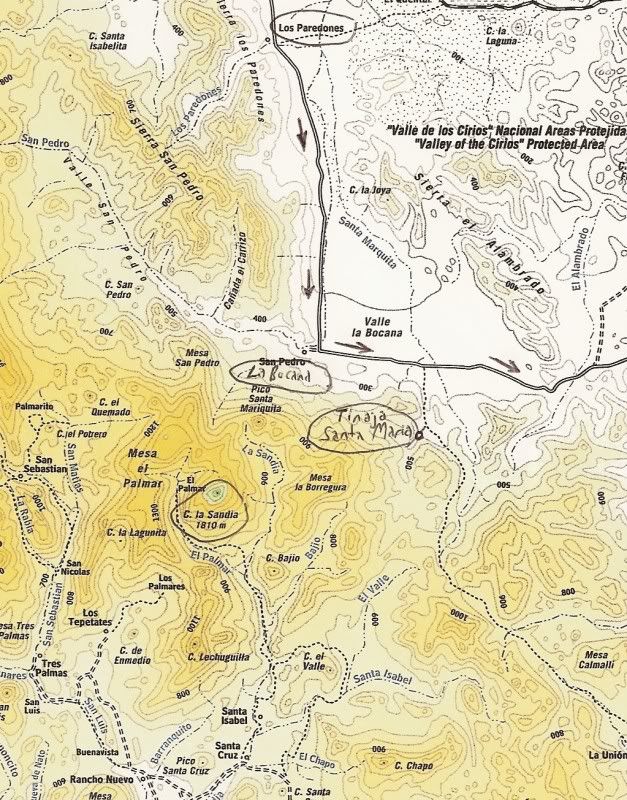
Even this modern map shows part of the Camino Real near Tinaja Santa Maria...
This location for our first 'Lost Mission' hunt was picked by Jesus Flores who was also a guide for Erle Stanley Gardner... We were so lucky to have
him guide us, as well! Doc (Abraham) of Camp Gecko made the arrangement for Jesus to show us... We did show him the Choral Pepper photos of what we
wanted to see... However, he may have heard the name SANTA MARIA MAGDALENA mentioned along with this wall... and assumed 'Santa Maria' is where we
wanted to go.
Here is Jesus at the Las Flores graveyard talking about his old friend Dick Daggett...

Here, on my next trip south, Jesus was riding by Camp Gecko and I asked him to autograph his photo in the 1961 Gardner book 'Hidden Heart of Baja'...

Jesus, over 40 years earlier in Erle Stanley Gardner's book:

Do you want to go into this area and see the Tinaja Santa Maria?:
GPS DIRECTIONS: L.A. BAY & SOUTH (map datum: WGS 84)
Casa Diaz, Bahia de los Angeles: N28°56.77' W113°33.55'
Camp Gecko, south of town: N28°54.05' W113°31.73'
Las Flores (jail house): N28°49.10' W113°31.77'
Jcn. with old road south: N28°40.77' W113°25.45'
Arroyo to Las Venecas: N28°39.40' W113°25.86'
Road to Paredones, Jesus' ranch: N28°36.81' W113°24.59'
Road ahead to La Bocana & San Pedro, turn sharp left (east): N28°28.40' W113°23.47'
We turn right, off road here: N28°28.01' W113°20.46' and head up the wide arroyo.
Tinaja de Santa Maria: N28°26.09' W113°20.02'
[Edited on 12-22-2008 by David K]
|
|
|
David K
Honored Nomad
        
Posts: 65437
Registered: 8-30-2002
Location: San Diego County
Member Is Offline
Mood: Have Baja Fever
|
|
Many of you knew or have read Tom Miller... author of The Baja Book, Baja Book II, Baja Book III, fishing books and Western Outdoor News Baja column.
In all three editions of Tom's 'The Baja Book', he gave credit to the site discovered by the Gardner crew and recognized as a possible mission site by
Choral Pepper in her book...
Here's the mission site mentioned in Tom's book (close up of the site paragraph is below):
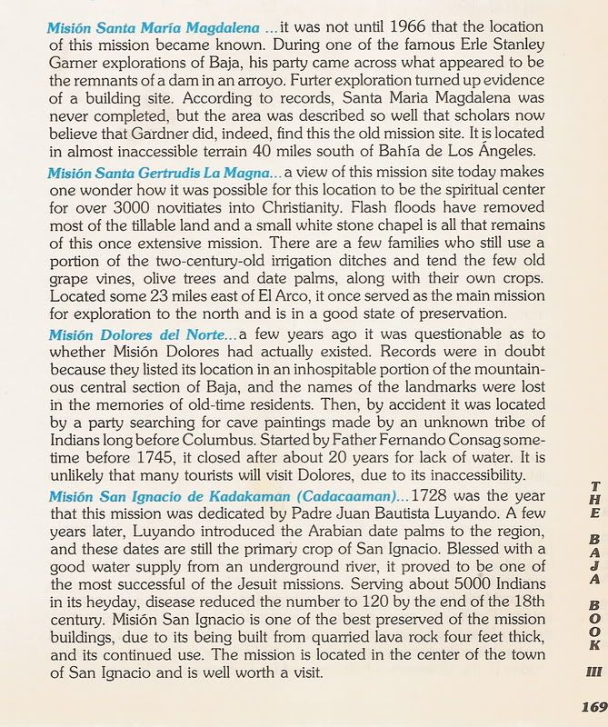

40 miles from Bahia de los Angeles... almost inaccessible terrain... almost???
One more time, the only known photographs taken at the discovery (from Desert Magazine, July, 1966):
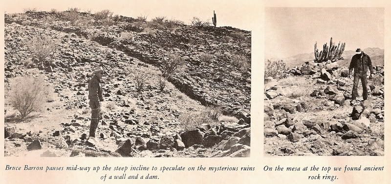
Armed with some new information a good Nomad has shared with me... perhaps one more search is in order!
|
|
|
Barry A.
Select Nomad
      
Posts: 10007
Registered: 11-30-2003
Location: Redding, Northern CA
Member Is Offline
Mood: optimistic
|
|
David-------I have a copy of that Desert Mag July 1966, and also Miller's book--------I think I will be doing a little homework tonight, or tomorrow
on that "lost mission" site. 
Great stuff!!! You have really piqued my interest------.
Barry
|
|
|
David K
Honored Nomad
        
Posts: 65437
Registered: 8-30-2002
Location: San Diego County
Member Is Offline
Mood: Have Baja Fever
|
|
Baja Angel and I are leaving in the morning... Baja Lou's turkey fiesta, a visit with BajaRob & Connie, then SOUTH we go! South some "40
inaccessible miles", that is! Choral Pepper always hoped to inspire people to explore the desert... and she did a great job!
It will be great fun to photograph the same wall as did Choral Pepper almost 43 years ago!!!
Of course, you know I have searched 6 times before... 40 miles south, beginning in 2001 with a bunch of us Amigos de Baja, now Baja Nomads. Included
in that first search were Mike Humfreville, Neal Johns, El Camote, Paulina, Desert Rat, David Eidell and a few more.
I hope to have a great report and share the glory with a fellow Baja Nomad who has given me a tip that seems real promissing!
In fact, if it wasn't for the tip... we would just take it easy on the beach for 4 days at Bahia Santa Maria/ Shell Island! The things that Baja Nomad
does to spur me on a new adventure!!!
Wish us success!
|
|
|
BAJACAT
Ultra Nomad
    
Posts: 2902
Registered: 11-21-2005
Location: NATIONAL CITY, CA
Member Is Offline
|
|
Good for it DK, msome day you will find it, I know..
|
|
|
David K
Honored Nomad
        
Posts: 65437
Registered: 8-30-2002
Location: San Diego County
Member Is Offline
Mood: Have Baja Fever
|
|
Thanks you José... Feliz Año Nuvo!!!
|
|
|
Barry A.
Select Nomad
      
Posts: 10007
Registered: 11-30-2003
Location: Redding, Northern CA
Member Is Offline
Mood: optimistic
|
|
As a preliminary answer------there are "sleeping circles" all over Baja CA. and southern CA deserts, and many can be observed in Anza-Borrego Desert
State Park, east of San Diego. There are some beautiful ones around Bahia de Los Angeles, easily reached from various places along the bay.
Barry
|
|
|
David K
Honored Nomad
        
Posts: 65437
Registered: 8-30-2002
Location: San Diego County
Member Is Offline
Mood: Have Baja Fever
|
|
| Quote: | Originally posted by BAJACAT
Good for it DK, msome day you will find it, I know.. |
That day came on Jan. 2, 2009... see the photos starting here: http://forums.bajanomad.com/viewthread.php?tid=36243
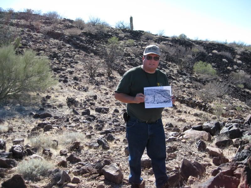
[Edited on 1-6-2009 by David K]
[Edited on 8-28-2017 by David K]
|
|
|
Barry A.
Select Nomad
      
Posts: 10007
Registered: 11-30-2003
Location: Redding, Northern CA
Member Is Offline
Mood: optimistic
|
|
Bump-------to get the related posts together in "today's posts"
|
|
|
David K
Honored Nomad
        
Posts: 65437
Registered: 8-30-2002
Location: San Diego County
Member Is Offline
Mood: Have Baja Fever
|
|
New web page showing Choral Pepper's photos of 1966 and mine of 2009 at the same place!: http://vivabaja.com/109
|
|
|
David K
Honored Nomad
        
Posts: 65437
Registered: 8-30-2002
Location: San Diego County
Member Is Offline
Mood: Have Baja Fever
|
|
Baja is just full of great adventures! Do some reading and then get into the desert and explore! This was just over 4 years ago and one of the best
trips, finding something that meant so much to Choral Pepper and something I had wanted to see for most of my life.
|
|
|
| Pages:
1
2 |

